BlockBefore
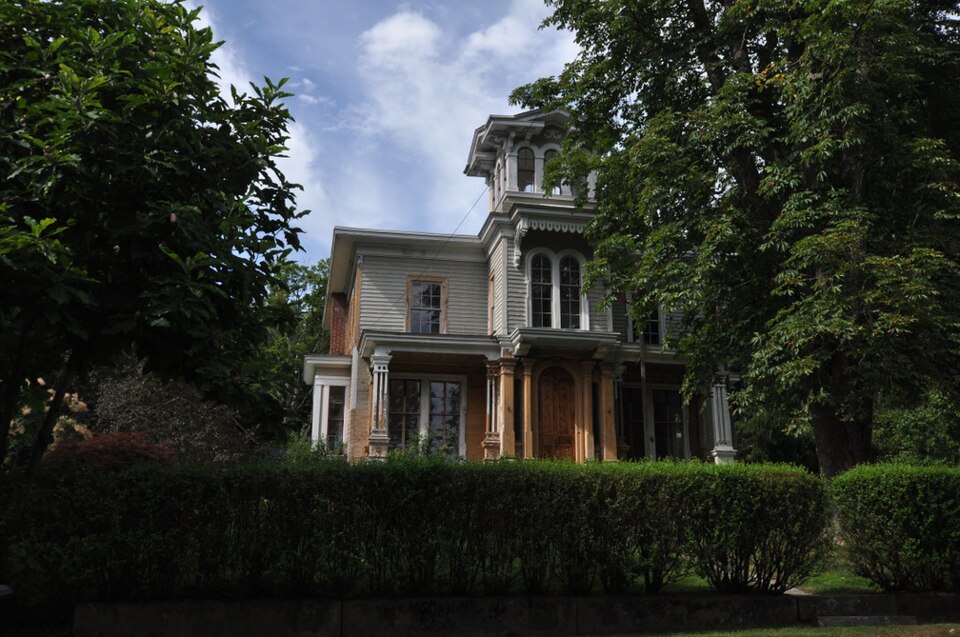
Photograph of Frederick S. Sanford House
Photograph by Magicpiano, CC BY-SA 3.0. Via Wikimedia Commons.

Frederick S. Sanford House

Listed on the National Register of Historic Places in 1989.

From the record

“Sanford House is a historic house on Hat Shop Hill Road in Bridgewater, Connecticut. Probably built in the early 19th century, it was extensively altered later in that century, achieving an exterior Italianate form that is the finest in the town, and an interior exhibiting various stages of alteration.”

Wikipedia article Frederick S. Sanford House, CC BY-SA 4.0.

One of 166 National Register listings published here for Litchfield County · listed in 1989 · category: Building.

Sources: the Wikipedia article · the case file at the National Archives · the National Register database, National Park Service
The listing

  • What is counted as historic. The nomination lists 1 building as contributing to the listing.
  • Listed as. Sanford, Frederick S., House - the National Register files a house under its owner's surname.
  • Address. Hat Shop Hill, Bridgewater, 06752
  • When was it listed? January 1989
  • Category. building
  • Town. Bridgewater town
  • Architectural style. Greek Revival architecture, Gothic Revival
  • National Register reference number. 88003230 - the number the National Park Service assigned this property when it was listed, and the key its nomination file is catalogued under at the National Archives.

The ground it stands on

6,682 words

The chapter on Bridgewater Town in History of Litchfield County, Connecticut, published 1881 names Bridgewater. This is what it says, exactly as the scans read.

The first ecclesiastical society in Bridgewater was organized in the year. 1803. Up to that year it was a part of the first society in New Milford. At the session of the General Assembly in said year action was taken upon the petition of Truman Minor et al., to be set off as a district society, on " account of the inconveniences which thej' sutt'er by continuing a part of the New Milford Society." The petition bears date " April 30, 1803," and was granted. The limits of the society, as specified in the act of the Legislature, were the same as those of the present town of Bridgewater. Those seem to have been based originally upon what - as to its northern boundary - was known as the " established military lines in said Neck" (probably the limit of a company of the militia.)

Passage source: History of Litchfield County, Connecticut, published 1881.

Mr. Keeler represented the town of New Milford in the Legislature of 1856, when Bridgewater was incorporated as a separate town. He was elected for the express purpose of securing the act of incorporation, and after much laborious effort the desired object was accomplished, as we have before stated. He also represented Bridgewater in the Legislature of 1879. He held a magistrate's commission for many years ; was for several years in succession a selectman ; has also been assessor and member of the board of relief, and has, in fact, filled nearly all the town ofiices. He has ever been generous, and personally active in urging and sustaining every measure promotive of the public welfare. Every scheme for the moral, religious, educational, and general welfare of the community has found in him an ardent and persevering friend. He has long been a communicant and prominent parishioner of St. Mark's Protestant Episcopal Church, and his name, wherever known, is a synonym for integrity and worth.

Passage source: History of Litchfield County, Connecticut, published 1881.

Machine-read from a century-old scan, so expect the errors a machine makes: misspelled names, dropped words, stray characters.

Read the whole chapter on Bridgewater Town - 6,682 words on its settlement, mills, schools and churches.

Fires near this property

140 since 1992

Regional context, not property-specific evidence. The federal wildfire occurrence database lists 140 fires within 5 miles of Frederick S. Sanford House between 1992 and 2020, burning about 165 acres in total. None started naturally. 11 were recorded as arson. Distance is straight-line from the map coordinates, so a fire counted here may appear on a neighbouring settlement's page as well.

Reported cause Fires
Missing data/not specified/undetermined68
Debris and open burning20
Recreation and ceremony16
Arson/incendiarism11
Misuse of fire by a minor10
Railroad operations and maintenance6
Equipment and vehicle use4
Smoking3
Fireworks1
Other causes1

The most recent of them, most recent first, with the day each was reported and the service that recorded it.

DateCause SizeReported by Name on the report
22 September 2010Missing data/not specified/undeterminedunder an acreConnecticut Division of Forestrynot named
19 September 2012Missing data/not specified/undeterminedunder an acreConnecticut Division of ForestryBRIDGEWATER
12 September 2020Missing data/not specified/undeterminedunder an acreConnecticut Division of ForestryTOWN LINE ROAD
11 September 1995Smoking2.0 acresConnecticut Division of Forestrynot named
9 August 2006Missing data/not specified/undetermined1.0 acresConnecticut Division of Forestrynot named
6 August 1994Recreation and ceremonyunder an acreConnecticut Division of Forestrynot named
4 August 2020Missing data/not specified/undetermined1.0 acresConnecticut Division of Forestry55 ROCKY HILL ROAD
31 August 2010Missing data/not specified/undeterminedunder an acreConnecticut Division of Forestrynot named

Every fire recorded in Litchfield County

Mines and quarries near this property

10 of 33 shown

Regional context, not property-specific evidence. The federal mineral resources record lists 33 workings within 5 miles of Frederick S. Sanford House: 28 past producers, 3 producers, 2 occurrences. 3 still produce. What was taken out: Sand and Gravel, Construction, Garnet, Iron, Stone, Dimension. Distance is straight-line from the map coordinates, so a quarry counted here may appear on a neighbouring settlement's page as well.

Where SiteCommodity StatusRecorded
Brookfield MineLeadPast Producer
Dolomitic Marble Rock Quarries No. Fk-001Limestone, GeneralPast ProducerUnknown
E. Paul Kovacs Crushed Rock Products QuarryStone, Crushed/BrokenProducer1963
Limestone QuarryLimestone, DimensionPast Producer
Rockside Granite Gneiss QuarryGranitePast Producer
Roxbury Iron MineIron, Copper, Silver, LeadPast ProducerVein Quartz In Fault Zone
Roxbury Iron MineIron, SilverPast ProducerVein
Roxbury MineSilica, ZincPast Producer
Judds Bridge Kyanite ProspectsKyaniteOccurrenceMetamorphic
Mine Hill Quartz Quarry No. Fj-012QuartzPast Producer

Every working recorded in Litchfield County

Map coverage status

No historic map-sheet match is published for this property yet. That does not mean no map exists. This record needs a coordinate-quality review before it can be joined to a sheet boundary. Browse the county's mapped places while that work is pending.

Listed places nearby

6 within 8 miles

Other National Register properties close enough to walk or drive between, ordered by distance from this one. Both positions come from the same geocoding pass that matched these properties to their map sheets.

Photograph PropertyDistance Listed
Bridgewater Center Historic District0.3 miles2000
Lover's Leap Bridge1.8 miles1976
J. S. Halpine Tobacco Warehouse3.2 miles1982
Merritt Beach & Son Building3.5 miles1992
Wildman, E. A., & Co. Tobacco Warehouse3.5 miles1988
Housatonic Railroad Station3.5 miles1984

Sources for this property

National Archives recordThe nomination case file for reference 88003230 in Record Group 79.
Wikipedia articleCommunity-written account of this property, licensed CC BY-SA.
Litchfield CountyAll 166 listed properties in this county.

Provenance

  • Listing record. National Park Service National Register of Historic Places, listed-properties dataset, current to 2026-05-22.
  • Map join. Address geocoded through the United States Census geocoder, then tested against the published boundary of every sheet in the USGS Historical Topographic Map Collection.
  • How this page is made. Listing fields come from federal records; map-sheet coverage is a labelled coordinate-to-boundary calculation, not a source-field claim.
  • Wildfire. Short, Karen C. 2022. Spatial wildfire occurrence data for the United States, 1992-2020 [FPA_FOD_20221014]. 6th Edition. Fort Collins, CO: Forest Service Research Data Archive. https://doi.org/10.2737/RDS-2013-0009.6 Collected with United States Government funding and usable without additional permissions or fees.
  • Mines and quarries. USGS Mineral Resources Data System (MRDS) https://mrdata.usgs.gov/mrds/ A work of the United States government, no copyright under 17 U.S.C. 105.