BlockBefore
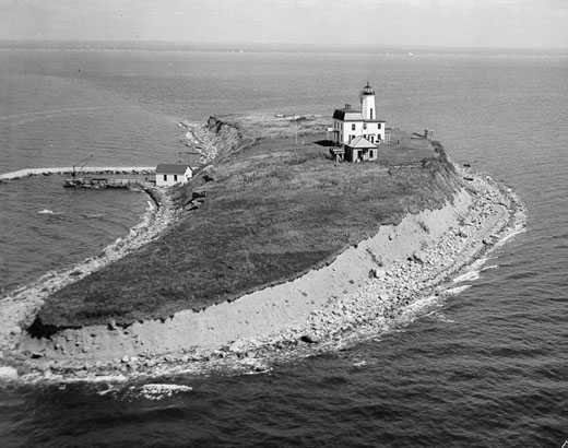
Photograph of Falkner Island Light
Photograph by Unknown, Public domain. Via Wikimedia Commons.

Falkner's Island Lighthouse

Built in 1802. Listed on the National Register of Historic Places in 1990.

From the record

“Falkner Island Light, also known as the Faulkner Island Lighthouse, is a lighthouse in Connecticut, United States, on Falkner Island which is off Guilford Harbor on Long Island Sound. The lighthouse was constructed in 1802 and commissioned by President Thomas Jefferson.”

Wikipedia article Falkner Island Light, CC BY-SA 4.0.

One of 272 National Register listings published here for New Haven County · listed in 1990 · category: Structure · built in 1802, by Abisha Woodward.

Sources: the Wikipedia article · the case file at the National Archives · the National Register database, National Park Service

The listing

  • What is counted as historic. The nomination lists 1 structure as contributing to the listing.
  • Address. Long Island Sound, 5 mi. S of Guilford, Guilford
  • When was it listed? May 1990
  • Category. structure
  • Also known as. Operating Lighthouses in Connecticut MPS
  • When was it built? 1802
  • Architect. Abisha Woodward
  • National Register reference number. 89001467 - the number the National Park Service assigned this property when it was listed, and the key its nomination file is catalogued under at the National Archives.

Mines and quarries near this property

2 within 5 miles

Regional context, not property-specific evidence. The federal mineral resources record lists 2 workings within 5 miles of Falkner's Island Lighthouse: 2 past producers. None of them still produces. What was taken out: Stone, Dimension, Granite. Distance is straight-line from the map coordinates, so a quarry counted here may appear on a neighbouring settlement's page as well.

Where SiteCommodity StatusRecorded
Sachem Head Granite Gneiss Rock QuarryStone, DimensionPast Producer1893
Sacher Hill Sachem Head ? QuarryGranitePast Producer

Every working recorded in New Haven County

Storms near this property

16 since 1998

Regional context, not property-specific evidence. The National Weather Service names Guilford, the town this property stands in, in 16 storm reports between 1998 and 2025: 12 thunderstorm wind, 1 hail, 1 flood, 1 lightning. No death or injury is recorded in these reports. Each account below is quoted exactly as the forecast office filed it, from the NOAA Storm Events Database, and each date opens the federal record of that event.

WhenEvent Place namedHarm What the report says
July 2009Thunderstorm WindGuilford$12,500Numerous trees were reported down in Guilford, including one which fell on a car.
June 2021Thunderstorm WindGuilford$10,000Multiple trees reported down in Guilford with time estimated by radar.
August 2012Thunderstorm WindGuilford$10,000Several trees and numerous tree limbs were reported down throughout the town. This included one tree down on a house and three large trees, over one foot in diameter, down onto power lines near U.S. Route 1.
March 2010FloodGuilford$10,000Long Hill Rd. in Guilford was closed with moderate flooding occurring. Over a dozen basements at the Wharton Brook Dr. and Louis Circle were flooded in Wallingford.||Total rainfall amounts received across New Haven County ranged from 4.15 inches at Tweed New Haven Regional Airport in New Haven to 5.75 inches in Wallingford.
July 2025Thunderstorm WindGuilford$8,000Multiple streets closed due to downed trees and wires throughout town including Durham Road, Nortontown Road, Moose Hill Road, and South Fair Street.
June 2011Thunderstorm WindGuilford$7,500Numerous trees were reported down in Guilford.
June 2021Thunderstorm WindGuilford$7,000Report from mPing, 3 inch tree limbs broken and power lines broken.
May 2018Thunderstorm WindNorth Guilford$7,000Numerous trees down.
September 2018Flash FloodGuilford-Route 146 between the towns of Madison and Guilford was closed due to flooding.
August 2012Thunderstorm WindGuilford-Large branches were reported down on power lines.
July 2010LightningGuilford-A woman was indirectly struck by lightning resulting in minor burns on her leg.
May 2002Thunderstorm WindGuilford-As a line of severe thunderstorms moved southeast, it produced high winds that downed trees and power lines in Guilford.
July 2001Thunderstorm WindGuilford-no account filed
May 2000HailGuilford-no account filed
June 2000Thunderstorm WindGuilford-no account filed
September 1998Thunderstorm WindGuilford-no account filed

Every storm recorded in New Haven County

Map coverage status

No historic map-sheet match is published for this property yet. That does not mean no map exists. This record needs a coordinate-quality review before it can be joined to a sheet boundary. Browse the county's mapped places while that work is pending.

Listed places nearby

6 within 8 miles

Other National Register properties close enough to walk or drive between, ordered by distance from this one. Both positions come from the same geocoding pass that matched these properties to their map sheets.

Photograph PropertyDistance Listed
Jared Eliot House4.5 miles1985
Henry Whitfield House4.7 miles1972
Henry Whitfield House4.7 miles1997
Shelley House4.8 miles1989
Guilford Historic Town Center4.9 miles1976
Thomas Burgis II House5.0 miles2000

Sources for this property

National Archives recordThe nomination case file for reference 89001467 in Record Group 79.
Wikipedia articleCommunity-written account of this property, licensed CC BY-SA.
New Haven CountyAll 272 listed properties in this county.

Provenance

  • Listing record. National Park Service National Register of Historic Places, listed-properties dataset, current to 2026-05-22.
  • Map join. Address geocoded through the United States Census geocoder, then tested against the published boundary of every sheet in the USGS Historical Topographic Map Collection.
  • How this page is made. Listing fields come from federal records; map-sheet coverage is a labelled coordinate-to-boundary calculation, not a source-field claim.
  • Mines and quarries. USGS Mineral Resources Data System (MRDS) https://mrdata.usgs.gov/mrds/ A work of the United States government, no copyright under 17 U.S.C. 105.
  • Storms. NOAA National Centers for Environmental Information, Storm Events Database https://www.ncei.noaa.gov/stormevents/ A work of the United States government, no copyright under 17 U.S.C. 105. Narratives are quoted verbatim from the National Weather Service report and are not edited or summarised.