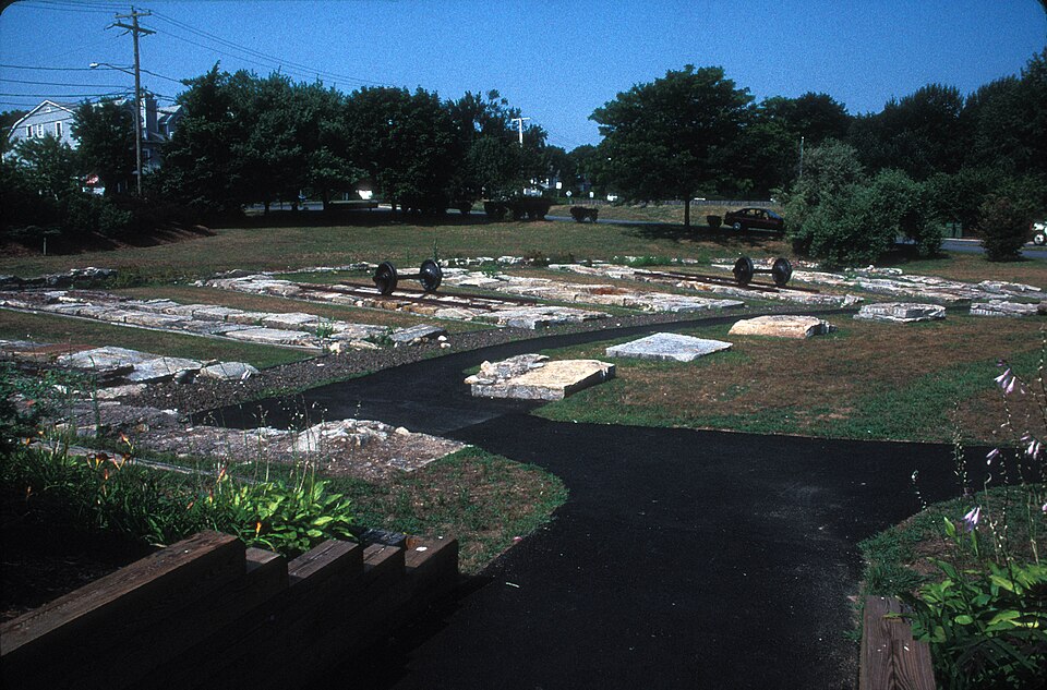
Connecticut Valley Railroad Roundhouse and Turntable Site
Listed on the National Register of Historic Places in 1994.
From the record
“The Connecticut Valley Railroad Roundhouse and Turntable Site is a former railroad facility located in Fort Saybrook Monument Park off Main Street in Old Saybrook, Connecticut. The roundhouse and turntable were built in 1871 by the Connecticut Valley Railroad, which was later acquired by the New York, New Haven and Hartford Railroad.”
Wikipedia article Connecticut Valley Railroad Roundhouse and Turntable Site, CC BY-SA 4.0.
One of 124 National Register listings published here for Middlesex County · listed in 1994 · category: Site.
National Register reference number.94000395- the number the National Park Service assigned this property when it was listed, and the key its nomination file is catalogued under at the National Archives.
Block was thus the first European navigator of the river, and probably the first to set foot on the site of what is now the town of Old Saybrook. Not long after this, the Dutch traders began to visit the country every year, and soon established a large trade with the natives; buying annually, it was said, not less than 10,000 beaver skins, beside such other commodities as the country could furnish.
When the English first entered the river, to take possession of Kievet's Hook, the first land on the west side of the river that met their gaze, was the " Neck," or Lynde's Point," as it was afterward called. This Neck was about two miles long, and nearly half a mile wide at its greatest breadth, and was bounded by the Sound on one side, and a cove, known as the South Cove, which is about a mile and a half long, and three-fourths of a mile wide, on the oilier side. North of this cove, and about a mile from the mouth of the river, was " Kievet's Hook," or Saybrook Point proper, which was formed by another cove putting up from the river, and known as the North Cove. This point was about a mile in length and about half a mile in breadth,the Neck where it joined the niiin land probably not being over an eighth of a mile in width, including the marsh. At the present time, the upland at the Neck, which is low, is only about ten or twelve rods wide, but there is quite a stretch of salt marsh, which has been, and is constantly encroaching upon the coves. The tides probably flowed across the neck, at every season of spring tides, as they do over the marshes on each side at the present time, but the road has been raised so much above its former level, that it has not turned the point into an island for several years. In fact it had not done so for many years, except when a heavy easterly storm occurred on the high course of tides. These coves are shallow, except in the channels which are narrow, and which extend but a short distance from the mouth, there being about four feet of water at high tide, and often almost none at all at low tide. The coves are constantly filling up, and the marshes which surround them on nearly all sides have extended considerably into them, within the memory of a generation, but there was undoubtedly quite a tract of marsh when the English took possession. It was the reeds and grass upon these marshes at this Neck that Lieut. Gardiner went out to burn on the 22d of February 1637 At this place afterward a row of palisades was extended across from cove to cove, a ditch was dug, and some kind of a fortification erected, with, of course, a guard to watch for hostile Indians. The gate through the palisades is several times mentioned in old deeds as " the Neck gate anciently so called." The North Cove at its mouth, where it joins the river, is quite deep, and forms what is called the " anchoring ground," where 50 vessels may anchor at once. An English book published early in the history of the colony, and giving some account of Saybrook, says that on each side of the point are two bays, in which several hundred sail of vessels may ride at anchor. The bays probably had not been sounded, at least by the writer of the book. These coves abounded with bass, chequit, eels, and crabs, and were the feeding ground of numerous flocks of wild ducks and geese in their season, while the fiats west of Cornfield Point furnished an abundant supply of clams. The river, and even the creeks, were alive with shad and salmon, and it is no wonder that it was a favorite resort of the Indians. Back from this neck, and from the sea coast, a plain, nearly level, and from one to two miles wide, stretched to the first tier of low hills, which abounded in the other sections of the town. The first stream west of Connecticut River was called Oyster River, from the natural beds of oysters that were found in it near its mouth. It rises near the northern boundary of the present town of Old Saybrook, and empties into the Sound about half a mile west of Cornfield Point. J^ike many or most of the Connecticut towns, a large part of its surface is broken and hilly, but the pl.iin upon which the principal part of the village stands is fertile and easy of cultivation. The soil on Saybrook Point, that on Lynde's Neck at the mouth of the river, and that in the village near the center is light, as is that in the Ferry District, but in Oyster River District the soil is a little heavier, and the farms are equal to any in the State.
Regional context, not property-specific
evidence. The
federal wildfire occurrence database
lists 80 fires within 5 miles of Connecticut Valley Railroad Roundhouse and Turntable Site
between 1993 and 2020, burning about 71 acres in total. None started naturally. 1 was recorded as arson.
Distance is straight-line from the map coordinates, so a fire counted
here may appear on a neighbouring settlement's page as well.
Reported cause
Fires
Missing data/not specified/undetermined
46
Recreation and ceremony
13
Debris and open burning
13
Smoking
5
Power generation/transmission/distribution
1
Misuse of fire by a minor
1
Arson/incendiarism
1
The most recent of
them, most recent first, with the day each was reported and the service
that recorded it.
Regional context, not property-specific
evidence. The federal mineral resources record lists
4 workings within 5 miles of Connecticut Valley Railroad Roundhouse and Turntable Site: 4 past producers.
None of them still produces. What was taken out: Granite, Stone, Stone, Dimension. Distance is straight-line from the
map coordinates, so a quarry counted here may appear on a neighbouring
settlement's page as well.
Regional context, not property-specific
evidence. The National Weather Service names
Old Saybrook, the town this property stands in, in 3 storm reports between 1995 and 2010: 2 thunderstorm wind, 1 funnel cloud.
No death or injury is recorded in these reports. Each account below is quoted exactly as the forecast office
filed it, from the NOAA Storm Events Database, and each date
opens the federal record of that event.
A squall line moving through the area generated thunderstorms strong enough to down numerous trees and power lines. Heavy rains also accompanied these storms which in turn caused some road and highway flooding.
No historic map-sheet match is published
for this property yet. That does not mean no map exists. This record needs
a coordinate-quality review before it can be joined to a sheet boundary.
Browse the county's mapped places while that work is
pending.
Listed places nearby
6 within 8 miles
Other National Register properties close
enough to walk or drive between, ordered by distance from this one. Both
positions come from the same geocoding pass that matched these properties
to their map sheets.
Listing record. National Park Service National Register of Historic Places, listed-properties dataset, current to 2026-05-22.
Map join. Address geocoded through the United States Census geocoder, then tested against the published boundary of every sheet in the USGS Historical Topographic Map Collection.
How this page is made. Listing fields come from federal records; map-sheet coverage is a labelled coordinate-to-boundary calculation, not a source-field claim.
Wildfire. Short, Karen C. 2022. Spatial wildfire occurrence data for the United States, 1992-2020 [FPA_FOD_20221014]. 6th Edition. Fort Collins, CO: Forest Service Research Data Archive. https://doi.org/10.2737/RDS-2013-0009.6 Collected with United States Government funding and usable without additional permissions or fees.
Mines and quarries. USGS Mineral Resources Data System (MRDS) https://mrdata.usgs.gov/mrds/ A work of the United States government, no copyright under 17 U.S.C. 105.
Storms. NOAA National Centers for Environmental Information, Storm Events Database https://www.ncei.noaa.gov/stormevents/ A work of the United States government, no copyright under 17 U.S.C. 105. Narratives are quoted verbatim from the National Weather Service report and are not edited or summarised.
 Block