BlockBefore
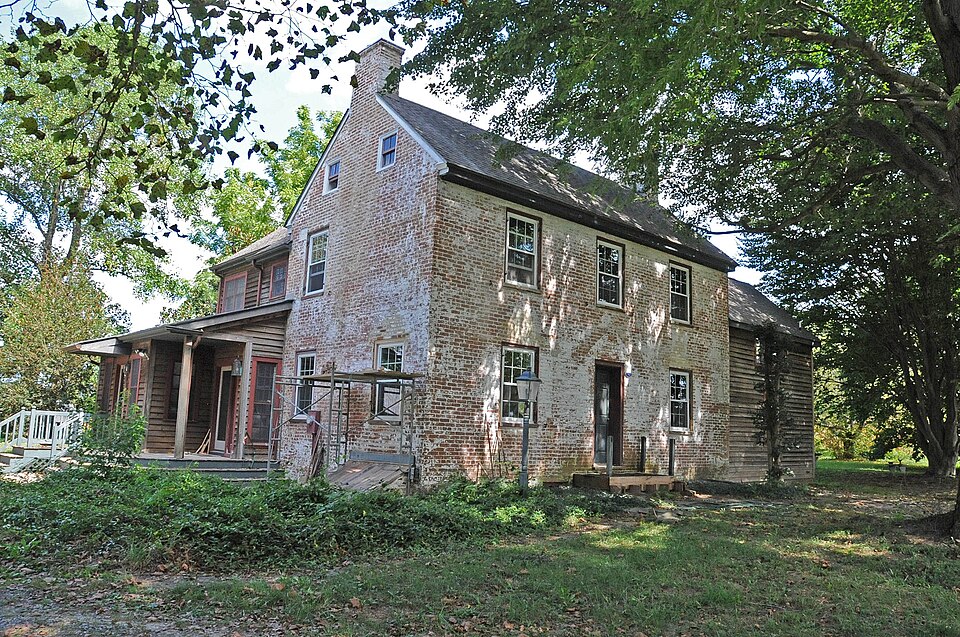
Photograph of Lewis Family Tenant Agricultural Complex
Photograph by JERRYE & ROY KLOTZ, M.D, CC BY-SA 4.0. Via Wikimedia Commons.

Lewis Family Tenant Agricultural Complex

Listed on the National Register of Historic Places in 1986.

From the record

“Lewis Family Tenant Agricultural Complex is a historic home and farm located at Wyoming, Kent County, Delaware. It was built in 1850, and consists of a dwelling and two contributing barns.”

Wikipedia article Lewis Family Tenant Agricultural Complex, CC BY-SA 4.0.

One of 136 National Register listings published here for Kent County · listed in 1986 · category: Building.

Sources: the Wikipedia article · the case file at the National Archives · the National Register database, National Park Service
The listing

  • Address. CR 227, Wyoming, 19934
  • When was it listed? August 1986
  • Category. building
  • Census division. Central Kent
  • National Register reference number. 86001506 - the number the National Park Service assigned this property when it was listed, and the key its nomination file is catalogued under at the National Archives.

Storms near this property

6 since 2003

Regional context, not property-specific evidence. The National Weather Service names Wyoming, the town this property stands in, in 6 storm reports between 2003 and 2020: 4 thunderstorm wind, 1 hail, 1 tornado. No death or injury is recorded in these reports. Each account below is quoted exactly as the forecast office filed it, from the NOAA Storm Events Database, and each date opens the federal record of that event.

WhenEvent Place namedHarm What the report says
September 2012Tornado (EF0)Wyoming$100,000An EF0 tornado touched down in the Barclay Farms Subdivision in Camden with an estimated maximum wind speed of 85 mph. The tornado damaged approximately ten homes, six of them seriously and caused two injuries. Six homes were considered uninhabitable and gas lines were turned off in the development. The tornado touched down on Dawson Lane and paralleled the train tracks from south to north. Structural damage to homes occurred from Dalby Lane north through Carey Lane. The tornado lifted after it passed Carey Lane. At one home, the wind tore the roof off a garage, damaging the two cars inside and the side of the home. The owner of the house was hospitalized after he cut his hand on a piece of broken glass. A firefighter was also injured assisting another resident. About 1,200 customers of the Delaware Electric Co-Operative lost power after the tornado moved through. All service was restored by 630 p.m. EDT that evening. The tornado's path length was approximately 0.2 miles and its maximum path width was 35 yards.
February 2020Thunderstorm WindWyoming-A loss of stockade fencing was reported in the area. Time estimated from radar.
July 2019Thunderstorm WindWyoming-Several reports of trees and wires down near Wyoming and Camden. Time estimated from radar.
May 2019Thunderstorm WindWyoming-Several trees were split or knocked down in the area of Camden and Wyoming.
April 2006HailWyoming-no account filed
August 2003Thunderstorm WindWyoming-no account filed

Every storm recorded in Kent County

Map coverage status

No historic map-sheet match is published for this property yet. That does not mean no map exists. This record needs a coordinate-quality review before it can be joined to a sheet boundary. Browse the county's mapped places while that work is pending.

Listed places nearby

6 within 8 miles

Other National Register properties close enough to walk or drive between, ordered by distance from this one. Both positions come from the same geocoding pass that matched these properties to their map sheets.

Photograph PropertyDistance Listed
Wyoming Railroad Station2.8 miles1980
Wyoming Historic District2.9 miles1987
Woodside Methodist Episcopal Church3.1 miles1996
Zion African Methodist Episcopal Church3.2 miles1994
Camden Friends Meetinghouse3.3 miles1973
Camden Historic District3.6 miles1974

Sources for this property

National Archives recordThe nomination case file for reference 86001506 in Record Group 79.
Wikipedia articleCommunity-written account of this property, licensed CC BY-SA.
Kent CountyAll 136 listed properties in this county.

Provenance

  • Listing record. National Park Service National Register of Historic Places, listed-properties dataset, current to 2026-05-22.
  • Map join. Address geocoded through the United States Census geocoder, then tested against the published boundary of every sheet in the USGS Historical Topographic Map Collection.
  • How this page is made. Listing fields come from federal records; map-sheet coverage is a labelled coordinate-to-boundary calculation, not a source-field claim.
  • Storms. NOAA National Centers for Environmental Information, Storm Events Database https://www.ncei.noaa.gov/stormevents/ A work of the United States government, no copyright under 17 U.S.C. 105. Narratives are quoted verbatim from the National Weather Service report and are not edited or summarised.