 Block
BlockBasinger, Florida
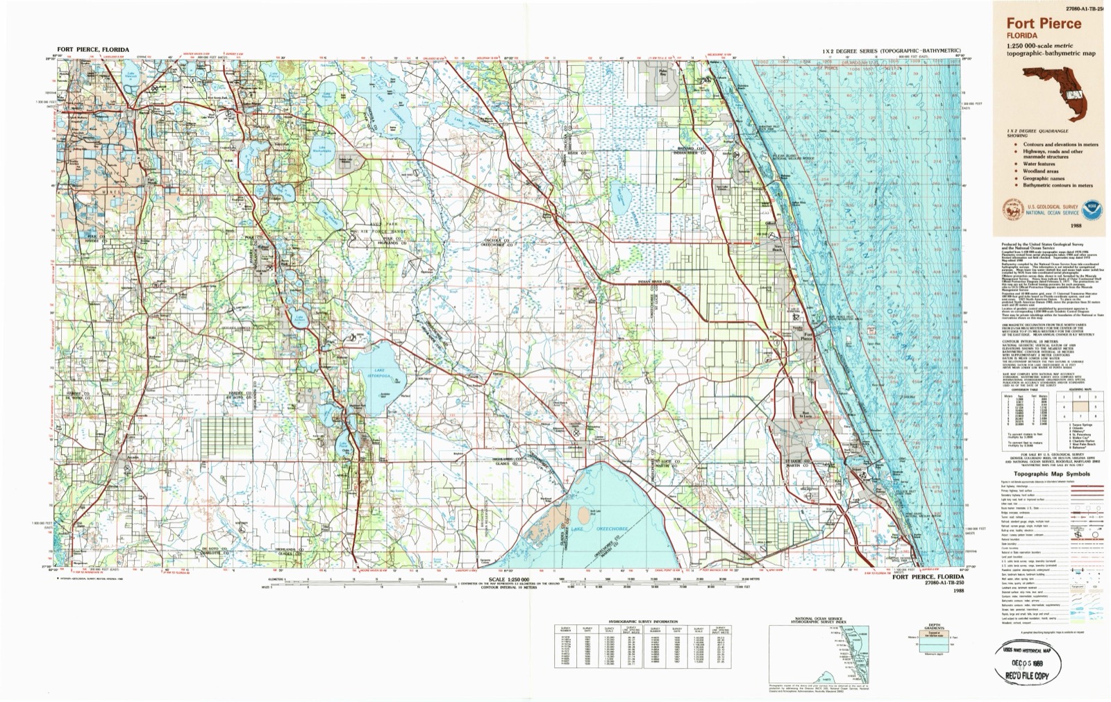
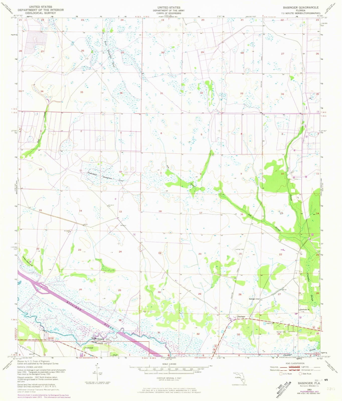
13 topographic sheets cover this place, the earliest surveyed in 1953 and the latest in 1988. It stands in the North Okeechobee census division. It lies in ZIP code area 34972. It stands on Gore Branch. The Survey maps it on the Basinger quadrangle.
Then and now
1953 to 1988The same ground, surveyed 35 years apart. Drag the handle to wipe between them. Both sheets are United States Geological Survey originals; neither has been altered.
Topographic sheets covering this place
6 surveys from 13 printed sheetsMatched by testing this settlement's coordinate against the published boundary of every sheet in the United States Geological Survey's historical collection. Each opens the scanned sheet at the Survey.
- 1953 USGS Basinger quadrangle1:24000, 3 printings
- 1956 USGS Fort Pierce quadrangle1:250000, 4 printings
- 1958 USGS Fort Pierce quadrangle1:250000
- 1959 USGS Fort Pierce quadrangle1:250000, 3 printings
- 1978 USGS Arcadia quadrangle1:100000
- 1988 USGS Fort Pierce quadrangle1:250000
Fires near this place
136 since 1992Regional context, not property-specific evidence. The federal wildfire occurrence database lists 136 fires within 5 miles of Basinger between 1992 and 2020, burning about 2,716 acres in total. 33 started naturally. 6 were recorded as arson. Distance is straight-line from the map coordinates, so a fire counted here may appear on a neighbouring settlement's page as well.
| Reported cause | Fires |
|---|---|
| Natural | 33 |
| Debris and open burning | 24 |
| Equipment and vehicle use | 23 |
| Missing data/not specified/undetermined | 21 |
| Railroad operations and maintenance | 13 |
| Power generation/transmission/distribution | 9 |
| Arson/incendiarism | 6 |
| Recreation and ceremony | 5 |
| Smoking | 1 |
| Misuse of fire by a minor | 1 |
The most recent of them, most recent first, with the day each was reported and the service that recorded it.
| Date | Cause | Size | Reported by | Name on the report |
|---|---|---|---|---|
| 4 September 2011 | Natural | 40 acres | Florida Forest Service | PINE HAMMOCK (47) |
| 3 September 2000 | Missing data/not specified/undetermined | 3.0 acres | Florida Forest Service | not named |
| 21 September 2009 | Equipment and vehicle use | under an acre | Florida Forest Service | (HI) 721 FIRE (703) |
| 20 September 1996 | Missing data/not specified/undetermined | 1.0 acres | Florida Forest Service | not named |
| 10 September 2005 | Equipment and vehicle use | 1.0 acres | Florida Forest Service | OK-FIRE-1162- |
| 7 August 2008 | Natural | 15 acres | Florida Forest Service | (OK) GATOR BAIT (0558) |
| 5 August 2015 | Missing data/not specified/undetermined | 120 acres | Florida Forest Service | MICCO BLUFF (47) |
| 24 August 2014 | Equipment and vehicle use | under an acre | Florida Forest Service | DOUGHERTY (28) |
Settlements close enough to share some of these fires:
Storms near this place
17 since 1996Regional context, not property-specific evidence. The National Weather Service names Basinger in 17 storm reports between 1996 and 2024: 7 hail, 4 thunderstorm wind, 2 funnel cloud, 2 tornado. The reports record 2 injuries. Each account below is quoted exactly as the forecast office filed it, from the NOAA Storm Events Database, and each date opens the federal record of that event.
| When | Event | Place named | Harm | What the report says |
|---|---|---|---|---|
| April 2017 | Thunderstorm Wind | Basinger | 2 hurt, $100,000 | A Kissimmee Prairie Preserve biologist reported that a storm flipped over two travel trailers, uprooted several large trees and caused sheet metal to become lodged in a tree. Two people within one of the trailers were injured, one suffered a punctured lung and several broken ribs and the other received very minor injuries. The damage was concentrated in the park from the equestrian campground to the family campground.|Follow-up information from Okeechobee Emergency Management and a NWS damage survey confirmed the impacts were the result of intense straight-line winds estimated near 80 mph, as a cluster of thunderstorms organized into a bow echo, then began to evolve into a supercell while continuing eastward. |
| October 2024 | Tornado (EF2) | Basinger | $900,000 | A tornado occurred, which produced localized EF-1 and EF-2 damage. Based on radar analysis and public video provided to the local emergency manager, the tornado touched down southeast of C & M Rucks Dairy.||While the tornado started over open pasture, damage occurred as it moved over C & M Rucks Dairy on NW 144th Ave. Here, a large steel barn with metal siding suffered a partial collapse on the southeast side, with at least 50% of the building destroyed.|Nearby power poles and lines were downed, and a power pole was snapped. The building damage was consistent with EF-2 winds of 105 to 115 mph. The path width was quite narrow, evidenced by nearby buildings which were untouched.||The tornado moved northwest from there, with sheet metal strewn along and west of NW 203rd St. There was no damage reported north of NW 240th St. Based on this and dual-polarimetric radar data, the tornado most likely lifted immediately south of NW 240th St over open pasture. |
| August 2017 | Thunderstorm Wind | Basinger | $2,000 | Okeechobee County Emergency Management forwarded a report and photos of damage at a residence in a rural area along the Kissimmee River between Basinger and Okeechobee. A tree was toppled and several large branches were downed, along with damage to a car and fence nearby. |
| August 2008 | Flood | Basinger | $1,200 | no account filed |
| October 2021 | Funnel Cloud | Basinger | - | Multiple trained spotters reported a funnel cloud with a strong thunderstorm over Kissimmee Prairie State Park. |
| February 2015 | Flood | Basinger | - | A slow moving strong storm across Okeechobee County produced 5 to 7 inches of rain across the northwest and central portions of the county during the afternoon and evening, primarily over the Kissimmee Prairie Preserve. The COOP observer at the Kissimmee Prairie Preserve reported 5.69 inches of rain in 24 hours while another range gauge at the park reported 6.92 inches. Most of this rainfall fell in less than 6 hours.||This heavy rainfall led to minor flooding of roadways across Central Okeechobee County. The Kissimmee Prairie observer reported several inches of standing water on local roadways, which remained passable. |
| February 2015 | Hail | Basinger | - | A SKYWARN spotter in The Vikings (also known at The Prairie) subdivision reported 10 to 15 minutes of small hail up to nickel sized associated with a strong storm moving over the area. |
| July 2012 | Thunderstorm Wind | Basinger | - | South Florida Water Management District site S65CW measured a thunderstorm wind gust of 60 mph along the Kissimmee River. |
| May 2005 | Tornado (F0) | Basinger | - | A small F0 tornado briefly touched down near Basinger blowing over a few trees. One inch hail was also reported in the area. |
| June 2003 | Funnel Cloud | Basinger | - | Local emergency management officials reported a funnel cloud over Basinger. |
| July 1997 | Thunderstorm Wind | Basinger | - | Thunderstorm winds blew down trees in Basinger. |
| May 2005 | Hail | Basinger | - | no account filed |
| May 2005 | Hail | Basinger | - | no account filed |
| August 2004 | Hail | Basinger | - | no account filed |
| July 1999 | Hail | Basinger | - | no account filed |
| May 1996 | Hail | Basinger | - | no account filed |
| August 1996 | Hail | Basinger | - | no account filed |
Nearest settlements
The eight closest, with where each one stands in the county. Distances are straight-line, computed from the Geographic Names Information System coordinates.
| Map | Place | Distance | Sheets |
|---|---|---|---|
| Dixie Ranch Acres | 7.8 miles | 13 | |
| Mildred | 9.2 miles | 13 | |
| Eagle Island | 9.6 miles | 13 | |
| Basswood Estates | 11.9 miles | 14 | |
| Whispering Pines | 12.6 miles | 14 | |
| Hilolo | 13.4 miles | 13 | |
| Barber Quarters | 13.9 miles | 14 | |
| Fort Drum | 14.1 miles | 14 |
Elsewhere
Matched on this settlement's Geographic Names Information System number rather than its name, so it cannot be a different place of the same name in another state.
| Wikidata item Q122567994 | The structured record the population and elevation above come from. Public domain (CC0). |
Provenance
This settlement is recorded in the Geographic Names Information System as feature 294666. The sheet list is computed by point-in-boundary test against the United States Geological Survey's historical topographic inventory. Both are works of the United States government and carry no copyright under 17 U.S.C. 105.
Wildfire. Short, Karen C. 2022. Spatial wildfire occurrence data for the United States, 1992-2020 [FPA_FOD_20221014]. 6th Edition. Fort Collins, CO: Forest Service Research Data Archive. https://doi.org/10.2737/RDS-2013-0009.6 Collected with United States Government funding and usable without additional permissions or fees.
Storms. NOAA National Centers for Environmental Information, Storm Events Database https://www.ncei.noaa.gov/stormevents/ A work of the United States government, no copyright under 17 U.S.C. 105. Narratives are quoted verbatim from the National Weather Service report and are not edited or summarised.