 Block
BlockForest City, Florida
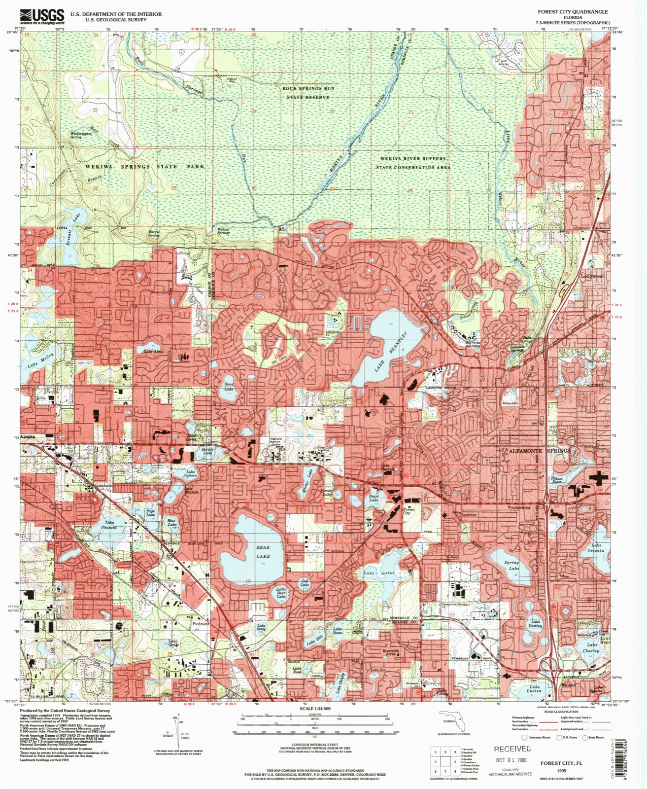
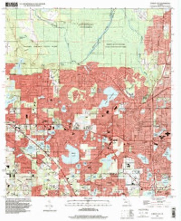
15 topographic sheets cover this place, the earliest surveyed in 1955 and the latest in 1995. It stands in the Casselberry-Altamonte Springs census division. It lies in ZIP code area 32703. The Survey maps it on the Forest City quadrangle. 14,623 people lived here at the 2020 count. It stands 95 feet above sea level.
Then and now
1955 to 1995The same ground, surveyed 40 years apart. Drag the handle to wipe between them. Both sheets are United States Geological Survey originals; neither has been altered.
Compare 1955 against another survey:
Population over time
3 figuresForest City grew from 12,612 to 14,623 between 2000 and 2020. These are the recorded population figures Wikidata holds for this place, reached through the Geographic Names Information System number this page is keyed on rather than by name, so they belong to this place and not to another of the same name. Most are census counts, but not all are: an early figure may be a founding or settlement estimate, and an estimate published within five years of a census is left out. The change column is computed, and is left blank where more than 20 years separate a figure from the one before it, because a gap that long is not a change between two counts.
| Year | People | Change |
|---|---|---|
| 2000 | 12,612 | |
| 2010 | 13,854 | +1,242 (+10%) |
| 2020 | 14,623 | +769 (+6%) |
Topographic sheets covering this place
7 surveys from 15 printed sheetsMatched by testing this settlement's coordinate against the published boundary of every sheet in the United States Geological Survey's historical collection. Each opens the scanned sheet at the Survey.
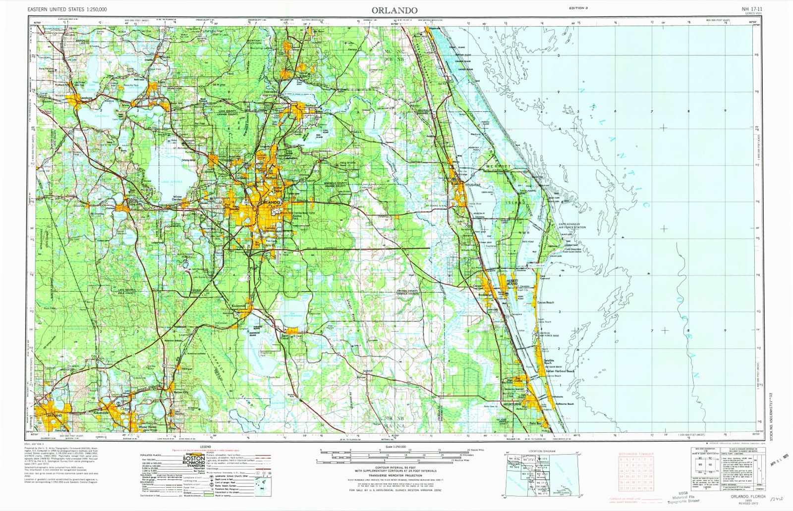
- 1955 USGS Orlando quadrangle1:250000, 3 printings
- 1957 USGS Orlando quadrangle1:250000
- 1958 USGS Orlando quadrangle1:250000
- 1959 USGS Forest City quadrangle1:24000, 5 printings
- 1962 USGS Orlando quadrangle1:250000
- 1979 USGS Orlando quadrangle1:100000, 3 printings
- 1995 USGS Forest City quadrangle1:24000
Fires near this place
28 since 1992Regional context, not property-specific evidence. The federal wildfire occurrence database lists 28 fires within 5 miles of Forest City between 1992 and 2019, burning about 276 acres in total. None started naturally. 9 were recorded as arson. Distance is straight-line from the map coordinates, so a fire counted here may appear on a neighbouring settlement's page as well.
| Reported cause | Fires |
|---|---|
| Arson/incendiarism | 9 |
| Railroad operations and maintenance | 8 |
| Missing data/not specified/undetermined | 6 |
| Equipment and vehicle use | 3 |
| Debris and open burning | 1 |
| Misuse of fire by a minor | 1 |
The most recent of them, most recent first, with the day each was reported and the service that recorded it.
| Date | Cause | Size | Reported by | Name on the report |
|---|---|---|---|---|
| 27 September 2012 | Debris and open burning | 5.0 acres | Florida Forest Service | JUNE BUG (48) |
| 12 July 1993 | Equipment and vehicle use | under an acre | Florida Forest Service | not named |
| 7 June 2008 | Arson/incendiarism | 2.0 acres | Florida Forest Service | COLD CAT FISH (04) |
| 26 June 2019 | Missing data/not specified/undetermined | 35 acres | Florida Forest Service | MEADOWS (48) |
| 24 June 2007 | Arson/incendiarism | under an acre | Florida Forest Service | GUMBALL (04) |
| 29 May 2007 | Missing data/not specified/undetermined | under an acre | Florida Forest Service | MEDUSA (04) |
| 28 May 2000 | Railroad operations and maintenance | 2.0 acres | Florida Forest Service | not named |
| 19 May 1993 | Railroad operations and maintenance | 20 acres | Florida Forest Service | not named |
Settlements close enough to share some of these fires:
Mines and quarries near this place
1 within 5 milesRegional context, not property-specific evidence. The federal mineral resources record lists 1 working within 5 miles of Forest City: 1 prospect. None of them still produces. What was taken out: Diatomite. Distance is straight-line from the map coordinates, so a quarry counted here may appear on a neighbouring settlement's page as well.
| Where | Site | Commodity | Status | Recorded |
|---|---|---|---|---|
| Unnamed Diatomite Deposits | Diatomite | Prospect |
Storms near this place
24 since 1997Regional context, not property-specific evidence. The National Weather Service names Forest City in 24 storm reports between 1997 and 2025: 8 hail, 8 thunderstorm wind, 3 funnel cloud, 3 lightning. The reports record 1 death and 1 injury. Each account below is quoted exactly as the forecast office filed it, from the NOAA Storm Events Database, and each date opens the federal record of that event.
| When | Event | Place named | Harm | What the report says |
|---|---|---|---|---|
| September 2020 | Lightning | Forest City | 1 killed | A 58 year old man was struck and killed by a lightning strike while grilling outdoors next to a tree. |
| July 2024 | Lightning | Forest City | 1 hurt | A 17 year-old male from Altamonte Springs was struck by lightning while outside performing lawn maintenance at his neighbor's home. The victim stated in interviews with local media that rain had just started to fall at the time of the incident. The victim was transported to the hospital and made a full recovery within several days. |
| March 2025 | Tornado (EF2) | Forest City | $3,900,000 | The circulation touched down at approximately 9:35 AM EDT near the southeastern edge of Wekiwa Springs State Park where it produced mainly vegetative damage in the form of downed oak and pine trees, with peak winds of 80 to 90 mph. The tornado continued on a northeast trajectory where it crossed a wooded area of the state park and into the Wingfield Reserve subdivision of Longwood. Here, more trees were downed in the vicinity of Alvarado Ct and Wingfield Dr due to winds of 80 to 85 mph.||More substantial damage was noted in the Whispering Winds subdivision where a significant number of oak trees were downed and snapped by EF-1 winds of up to 100 mph. Several residential structures within the subdivision near the intersection of Misty |Morn Pl and Blue Iris Pl experienced significant damage, including numerous blown out windows, damage to garage doors, as well as the loss of part of their roofs and awnings. The tornado likely peaked in this area, where a two-story wood framed home on Blue Iris Pl collapsed due to peak winds estimated up to 120 mph (EF-2 intensity).||The circulation weakened some while moving quickly toward the northeast across Markham Wood Rd and then towards Interstate 4, where mainly tree damage was noted. The tornado impacted a local news station on Skyline Dr before dissipating shortly thereafter at approximately 9:41 AM EDT. |
| June 2010 | Lightning | Forest City | $500,000 | Lightning associated with a strong thunderstorm struck a large estate home in the Sweetwater Club subdivision of Longwood. The home became fully engulfed in flames and officials declared it a total loss. |
| June 2012 | Thunderstorm Wind | Forest City | $15,000 | A SKYWARN spotter reported a balcony on an apartment complex being damaged by downed trees a quarter mile south of city hall in Altamonte Springs. Several other trees were also downed in the area. A photo was obtained. |
| February 2008 | Thunderstorm Wind | Forest City | $10,000 | Two greenhouse roofs were blown off at a nursery near Lake Brantley. |
| May 2025 | Funnel Cloud | Forest City | - | Emergency manager reports funnel cloud near State Road 434 and Wekiva Springs Rd. Did not appear to be descending. |
| September 2023 | Thunderstorm Wind | Forest City | - | Florida Department of Emergency Management measured a 50 knot wind gust. |
| September 2022 | Flash Flood | Forest City | - | Rainfall accumulations of 10 to 12 inches led to rapid water level rises along the Little Wekiva River late on Sep. 28 and early Sep. 29. Emergency Management officials indicated inundation of homes within the Spring Oaks subdivision of Altamonte Springs along Little Wekiva Rd. with nearly 2 to 4 feet of water breaching several properties. Numerous water rescues occurred during the overnight and early morning period as roadways quickly flooded and became impassible. The Little Wekiva reached a record crest of 31.09 ft. on Sep. 29. |
| June 2020 | Funnel Cloud | Forest City | - | A trained spotter reported a funnel cloud in the area of Interstate 4 and State Road 434 in Altamonte Springs. |
| June 2019 | Thunderstorm Wind | Forest City | - | Altamonte Springs Police Department relayed reports of trees down on cars near the intersection of Spring Valley Road and Wymore Road in Altamonte Springs. There were also downed trees across Ballard Street near the street's intersection with Maintland Avenue. In a nearby subdivision, an emergency management official reported a large tree was snapped on Hattaway Drive just south of State Road 436. |
| April 2017 | Hail | Forest City | - | A citizen near the intersection of SR434 and Wekiva Springs Road reported quarter sized hail. A few minutes later, a weather spotter nearby observed hail lasting four minutes with a maximum size of one inch. |
| June 2015 | Hail | Forest City | - | A Skywarn spotter reported nickel to quarter sized hail in Wekiva Springs. |
| August 2015 | Hail | Forest City | - | A citizen observed nickel-sized hail falling in Altamonte Springs. |
| September 2014 | Thunderstorm Wind | Forest City | - | A WeatherFlow station near the intersections of SR-434 and SR-436 in Altamonte Springs recorded a 58 mph wind gust out of the northwest as an isolated severe thunderstorm impacted the site. Additionally, a storm report from the public estimated winds of 60 mph at the same location and time. |
| April 2012 | Thunderstorm Wind | Forest City | - | A trained spotter recorded a 51kt/59mph thunderstorm wind gust on their local anemometer about one mile northwest of Sanlando Springs in Longwood. |
| June 2012 | Thunderstorm Wind | Forest City | - | A storm chaser measured a 62 mph thunderstorm wind gust on their Davis Vantage Pro weather station near Altamonte Springs. |
| August 2012 | Hail | Forest City | - | A spotter reported nickel-sized hail near I-4 and SR 434. |
| March 2011 | Thunderstorm Wind | Forest City | - | A weather spotter reported trees down at North Street and Suniland Street in Altamonte Springs, blocking the roadway. |
| March 2010 | Funnel Cloud | Forest City | - | An Orlando TV Station weather spotter observed a brief funnel cloud near the intersection of Interstate 4 and State Road 434 in Altamonte Springs. |
| June 2010 | Hail | Forest City | - | Public report of penny sized hail at highway 436 and Bear Lake Road. |
| June 2008 | Hail | Forest City | - | The public reported nickel size hail on Clemson Drive. |
| April 1997 | Hail | Forest City | - | Nickel size hail fell at Forest City. |
| April 1997 | Hail | Forest City | - | Nickel size hail fell at Forest City. |
Nearest settlements
The eight closest, with where each one stands in the county. Distances are straight-line, computed from the Geographic Names Information System coordinates.
| Map | Place | Distance | Sheets |
|---|---|---|---|
| Weathersfield | 2.4 miles | 15 | |
| Wekiwa Springs | 2.4 miles | 15 | |
| Orienta Gardens | 3.3 miles | 15 | |
| Sanlando Springs | 3.5 miles | 15 | |
| Altamonte Springs | 4.1 miles | 15 | |
| Fern Park | 5.0 miles | 15 | |
| Longwood | 6.1 miles | 15 | |
| Casselberry | 6.2 miles | 15 |
Elsewhere
Matched on this settlement's Geographic Names Information System number rather than its name, so it cannot be a different place of the same name in another state.
| Wikipedia article on Forest City | An encyclopaedic summary. Its text is share-alike, so it is linked here rather than copied. |
| Wikidata item Q2301375 | The structured record the population and elevation above come from. Public domain (CC0). |
Provenance
This settlement is recorded in the Geographic Names Information System as feature 294773. The sheet list is computed by point-in-boundary test against the United States Geological Survey's historical topographic inventory. Both are works of the United States government and carry no copyright under 17 U.S.C. 105.
Wildfire. Short, Karen C. 2022. Spatial wildfire occurrence data for the United States, 1992-2020 [FPA_FOD_20221014]. 6th Edition. Fort Collins, CO: Forest Service Research Data Archive. https://doi.org/10.2737/RDS-2013-0009.6 Collected with United States Government funding and usable without additional permissions or fees.
Mines and quarries. USGS Mineral Resources Data System (MRDS) https://mrdata.usgs.gov/mrds/ A work of the United States government, no copyright under 17 U.S.C. 105.
Storms. NOAA National Centers for Environmental Information, Storm Events Database https://www.ncei.noaa.gov/stormevents/ A work of the United States government, no copyright under 17 U.S.C. 105. Narratives are quoted verbatim from the National Weather Service report and are not edited or summarised.