 Block
BlockNorth Naples, Florida
15 topographic sheets cover this place, the earliest surveyed in 1956 and the latest in 1987. It stands in the Naples census division. It lies in ZIP code area 34108. The Survey maps it on the Naples North quadrangle.
Then and now
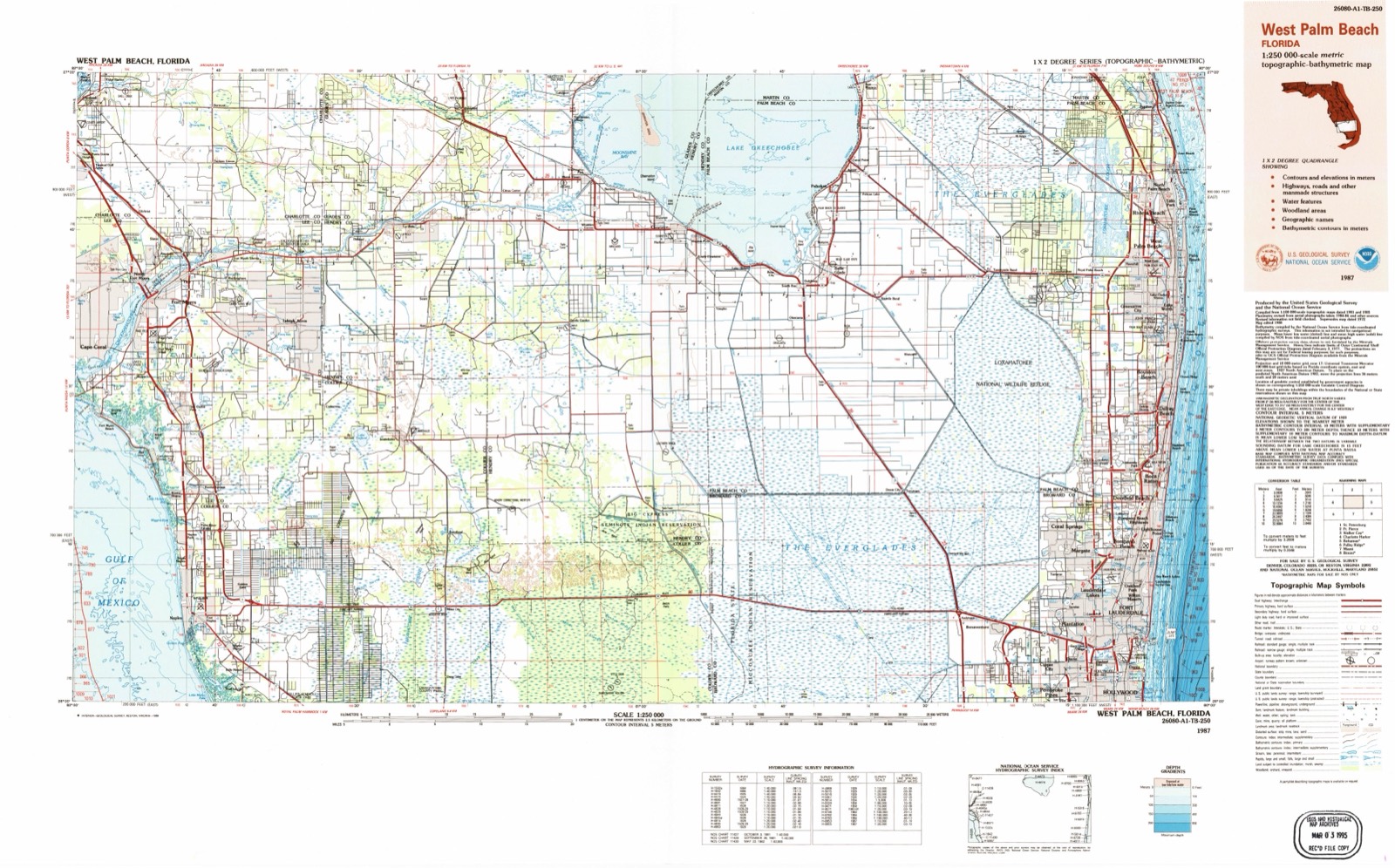
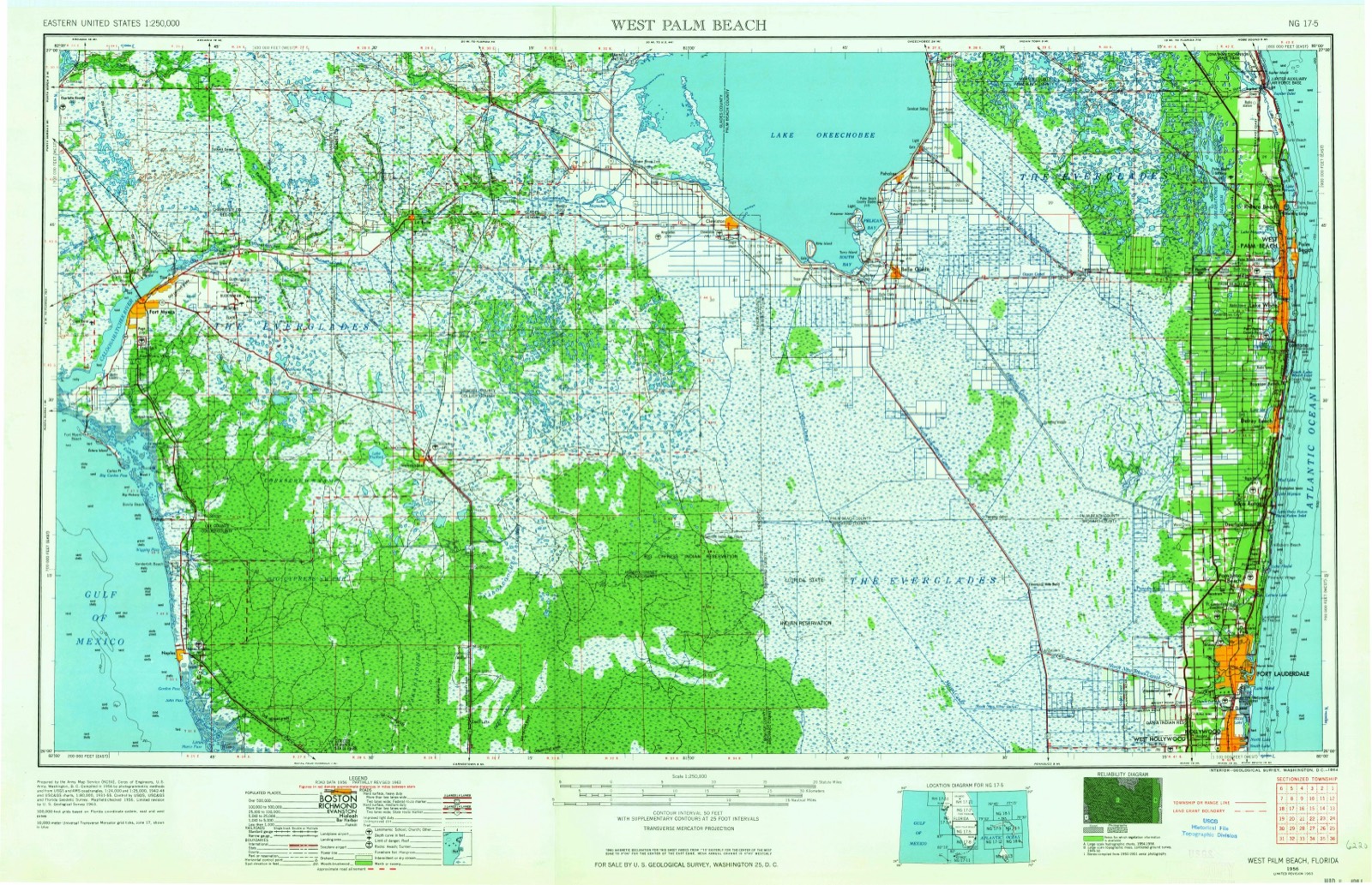
1956 to 1987The same ground, surveyed 31 years apart. Drag the handle to wipe between them. Both sheets are United States Geological Survey originals; neither has been altered.
Topographic sheets covering this place
6 surveys from 15 printed sheetsMatched by testing this settlement's coordinate against the published boundary of every sheet in the United States Geological Survey's historical collection. Each opens the scanned sheet at the Survey.
- 1956 USGS West Palm Beach quadrangle1:250000, 2 printings
- 1957 USGS West Palm Beach quadrangle1:250000
- 1958 USGS Naples North quadrangle1:24000, 6 printings
- 1958 USGS West Palm Beach quadrangle1:250000, 2 printings
- 1985 USGS Naples quadrangle1:100000, 2 printings
- 1987 USGS West Palm Beach quadrangle1:250000, 2 printings




Fires near this place
111 since 1992Regional context, not property-specific evidence. The federal wildfire occurrence database lists 111 fires within 5 miles of North Naples between 1992 and 2020, burning about 721 acres in total. 10 started naturally. 13 were recorded as arson. Distance is straight-line from the map coordinates, so a fire counted here may appear on a neighbouring settlement's page as well.
| Reported cause | Fires |
|---|---|
| Railroad operations and maintenance | 41 |
| Missing data/not specified/undetermined | 17 |
| Arson/incendiarism | 13 |
| Misuse of fire by a minor | 11 |
| Natural | 10 |
| Equipment and vehicle use | 9 |
| Debris and open burning | 7 |
| Power generation/transmission/distribution | 2 |
| Smoking | 1 |
The most recent of them, most recent first, with the day each was reported and the service that recorded it.
| Date | Cause | Size | Reported by | Name on the report |
|---|---|---|---|---|
| 14 September 1996 | Railroad operations and maintenance | under an acre | Florida Forest Service | not named |
| 3 August 2012 | Natural | 3.5 acres | Florida Forest Service | VIKING WAY (11) |
| 12 August 1993 | Natural | 3.0 acres | Florida Forest Service | not named |
| 1 August 2005 | Natural | under an acre | Florida Forest Service | 2005-17-0408 |
| 30 July 2019 | Natural | 2.0 acres | Florida Forest Service | JULIETTE (11) |
| 26 July 1993 | Natural | 3.0 acres | Florida Forest Service | not named |
| 22 July 2002 | Natural | under an acre | Florida Forest Service | not named |
| 16 July 2000 | Railroad operations and maintenance | 2.0 acres | Florida Forest Service | not named |
Settlements close enough to share some of these fires:
Storms near this place
27 since 1993Regional context, not property-specific evidence. The National Weather Service names North Naples in 27 storm reports between 1993 and 2022: 7 lightning, 6 hail, 5 thunderstorm wind, 3 tornado. The reports record 2 injuries. Each account below is quoted exactly as the forecast office filed it, from the NOAA Storm Events Database, and each date opens the federal record of that event.
| When | Event | Place named | Harm | What the report says |
|---|---|---|---|---|
| July 2021 | Lightning | North Naples | 2 hurt | Broadcast media relayed a report of two people, one adult and one child, struck by lightning on Clam Pass Beach in Naples. Injuries were minor to moderate and both persons were taken to a local hospital. |
| September 2013 | Lightning | North Naples | $2,000,000 | Lightning struck the Greater Naples YMCA building on Pine Ridge Road and induced a fire reported by the Fire Marshall. Firefighters responded to the fire at 330 PM EDT to the fire already in progress. About 20,000 square feet of the building was completely burned, with the Gym sustaining most of the damage. Damage was estimated at 2 million dollars. |
| May 2020 | Lightning | North Naples | $50,000 | Broadcast media reported a house fire due to a lightning strike near the corner of Ridge Dr and East Ave near North Naples. The family had safely evacuated the home by the time crews arrived on scene. Naples Fire-Rescue Department confirms a lightning strike hit the roof of a home, causing the flames. Damage totals are estimated. |
| April 1993 | Tornado (F0) | North Naples | $50,000 | Two mobile homes in Caribbean Mobile Home Park received minor damage from a small tornado. Screening around a pool was destroyed, a garage door buckled, and several trees were mangled or uprooted. Damage estimate was $25,000. |
| July 2007 | Lightning | North Naples | $40,000 | Lightning struck a house in Naples at 5220 Seahorse Drive. The roof was badly damaged, as well as a room in the back of the house. |
| July 1999 | Lightning | North Naples | $20,000 | no account filed |
| December 2007 | Tornado (EF0) | North Naples | $15,000 | A waterspout moved onshore along Pelican Bay's North Beach, causing damage to several structures at the Sandpiper Restaurant. The awning covering the restaurant's outdoor dining area was partially ripped off and part of its metal frame was damaged. Lounge chairs were thrown through several of the restaurant's windows, with chairs and beach umbrellas observed as far inland as Pelican Bay Boulevard, about a half-mile inland. ||Five vertical propane heaters were destroyed, and a 5-foot by 8-foot section of the roof was damaged. |
| June 2017 | Lightning | North Naples | $10,000 | Lightning struck the Greater Naples YMCA building around 6 PM, damaging the air conditioning to the 40,000 square foot gym as well as disabling the 24-hour wellness clinic, multi-station kitchen and fire alarm. No injuries were reported.||The building was significantly damaged by another lightning strike in September 2013. |
| July 2015 | Lightning | North Naples | $10,000 | Lightning hit the side of a house on Waxmyrtle Way in Naples. The resulting electrical current traveled through conduits to the attic, where extensive damage was reported. Two adults and two children were in the home at the time and were able to get out safely. The home was deemed unlivable at the time of the incident. |
| July 2004 | Tornado (F0) | North Naples | $5,000 | A tornado touched down in North Naples uprooting a large tree which damaged a house roof. |
| October 2016 | Flood | North Naples | $500 | Collier County Sheriff's Office reported the closures of Ridge Street at US 41 (Tamiami Trail) and Cooper Drive due to flooding. |
| August 2022 | Hail | North Naples | - | Hail of dime to penny size was observed in The Vineyards east of I-75 near Vanderbilt Beach Road. |
| April 2020 | Thunderstorm Wind | North Naples | - | A trained spotter called to report large tree limbs blown down from thunderstorms which moved through the area. A wind gust of 56 mph was measured around this time at the WeatherBug site at Naples Municipal Airport at a height of 104 feet. Additional estimated wind gusts in the area were in the 60-65 mph range. |
| April 2020 | Thunderstorm Wind | North Naples | - | A report from NBC2 Fort Myers with video from the public of storm damage associated with a thunderstorm with a nearby measured wind gust of 50 mph. Reports of tree limbs down and a lanai had screens torn near the intersection of Brynwood Preserve Lane and Livingston Road in Naples. |
| June 2020 | Flash Flood | North Naples | - | Numerous reports from the public and social media of widespread street flooding in downtown Naples near the intersection of south 9th street and south 5th avenue through West Lake in Downtown Naples, where a sports utility vehicle was largely submerged into a storm-drain runoff area. The significant flooding extended northward along North Tamiami Trail, North of Naples Bay, where water was seen extending over street surfaces onto sidewalks and continuing across Quail Run Golf Club in Naples just south of Pine Ridge Road, where a few cars were flooded by becoming partially submerged in flood waters. Areas of flooding extended a couple feet deep over streets and surrounding property. A report from an automated rain gauge within Wunderground Network -- Site ID KFLNAPLE256, which is located near the intersection of Leeward Lane and Putter Point Drive recorded a total of 4.7 inches of rain that fell in association with heavy showers and thunderstorms over several hours. |
| August 2017 | Flood | North Naples | - | Additional rainfall of 2 to 3 inches fell across Collier County during the early morning hours of August 26th. This lead to additional flooding along Logan Boulevard as well as Vanderbilt Beach. Several sections of these roadways were impassable due to flooding. |
| June 2015 | Thunderstorm Wind | North Naples | - | Trees down and a flag pole bent in half at a summer camp. Two large tents were destroyed. Time was estimated by radar. |
| June 2015 | Thunderstorm Wind | North Naples | - | Tree down at the intersection of Pine Ridge and Livingston Roads. |
| June 2015 | Thunderstorm Wind | North Naples | - | Trees down in the Vineyards at Vanderbilt Beach Rd. |
| June 2014 | Hail | North Naples | - | A trained spotter reported quarter size hail 3 miles east of North Naples. |
| June 2014 | Hail | North Naples | - | A member of the public reported half dollar size hail on I-75 near Pine Ridge Road. Report was received via social media. |
| June 2014 | Hail | North Naples | - | Facebook picture of 1.5 inch hail in Wilshire Lakes just north of Vanderbilt Beach Road and east of I-75. |
| August 2012 | Hail | North Naples | - | A trained spotter in North Naples reported lots of hail falling with some up to the size of pennies. |
| August 2001 | Waterspout | North Naples | - | The Sheriff's Office reported a waterspout in the Gulf of Mexico just offshore Barefoot Beach. |
| June 1998 | Funnel Cloud | North Naples | - | Funnel cloud reported by Collier County EOC near Pine Ridge Rd. |
| July 1997 | Funnel Cloud | North Naples | - | by collier county sheriffs office...no touchdown observed. |
| July 1997 | Hail | North Naples | - | golf ball size hail observed by corkscrew fire dept near everglades and immokalee rd. |
Nearest settlements
The eight closest, with where each one stands in the county. Distances are straight-line, computed from the Geographic Names Information System coordinates.
| Map | Place | Distance | Sheets |
|---|---|---|---|
| Pine Ridge | 0.8 miles | 15 | |
| Pelican Bay | 1.1 miles | 15 | |
| Pelican Marsh | 2.6 miles | 14 | |
| Naples Park | 3.1 miles | 14 | |
| Vanderbilt Beach Estates | 3.5 miles | 14 | |
| Vanderbilt Beach | 3.5 miles | 14 | |
| Four Seasons | 3.6 miles | 14 | |
| Palm River Shores | 3.8 miles | 14 |
Elsewhere
Matched on this settlement's Geographic Names Information System number rather than its name, so it cannot be a different place of the same name in another state.
| Wikipedia article on North Naples | An encyclopaedic summary. Its text is share-alike, so it is linked here rather than copied. |
| Wikidata item Q7056172 | The structured record the population and elevation above come from. Public domain (CC0). |
Provenance
This settlement is recorded in the Geographic Names Information System as feature 287841. The sheet list is computed by point-in-boundary test against the United States Geological Survey's historical topographic inventory. Both are works of the United States government and carry no copyright under 17 U.S.C. 105.
Wildfire. Short, Karen C. 2022. Spatial wildfire occurrence data for the United States, 1992-2020 [FPA_FOD_20221014]. 6th Edition. Fort Collins, CO: Forest Service Research Data Archive. https://doi.org/10.2737/RDS-2013-0009.6 Collected with United States Government funding and usable without additional permissions or fees.
Storms. NOAA National Centers for Environmental Information, Storm Events Database https://www.ncei.noaa.gov/stormevents/ A work of the United States government, no copyright under 17 U.S.C. 105. Narratives are quoted verbatim from the National Weather Service report and are not edited or summarised.