Block
BlockFrom the record
One of 4 National Register listings published here for DeSoto County · listed in 2011 · category: Building.
Sources: the case file at the National Archives · the National Register database, National Park Service
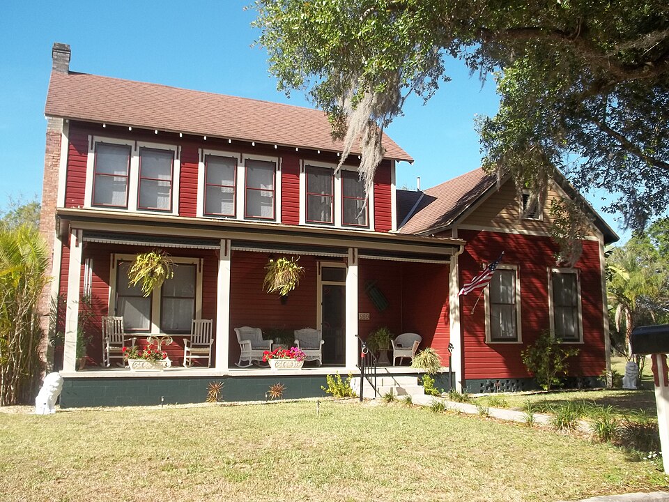
Listed on the National Register of Historic Places in 2011. 6 historic topographic surveys show this location, the earliest from 1956.
One of 4 National Register listings published here for DeSoto County · listed in 2011 · category: Building.
Sources: the case file at the National Archives · the National Register database, National Park Service
The ground this property stands on, surveyed 32 years apart. Drag the handle to wipe between them. Both sheets are United States Geological Survey originals; neither has been altered.
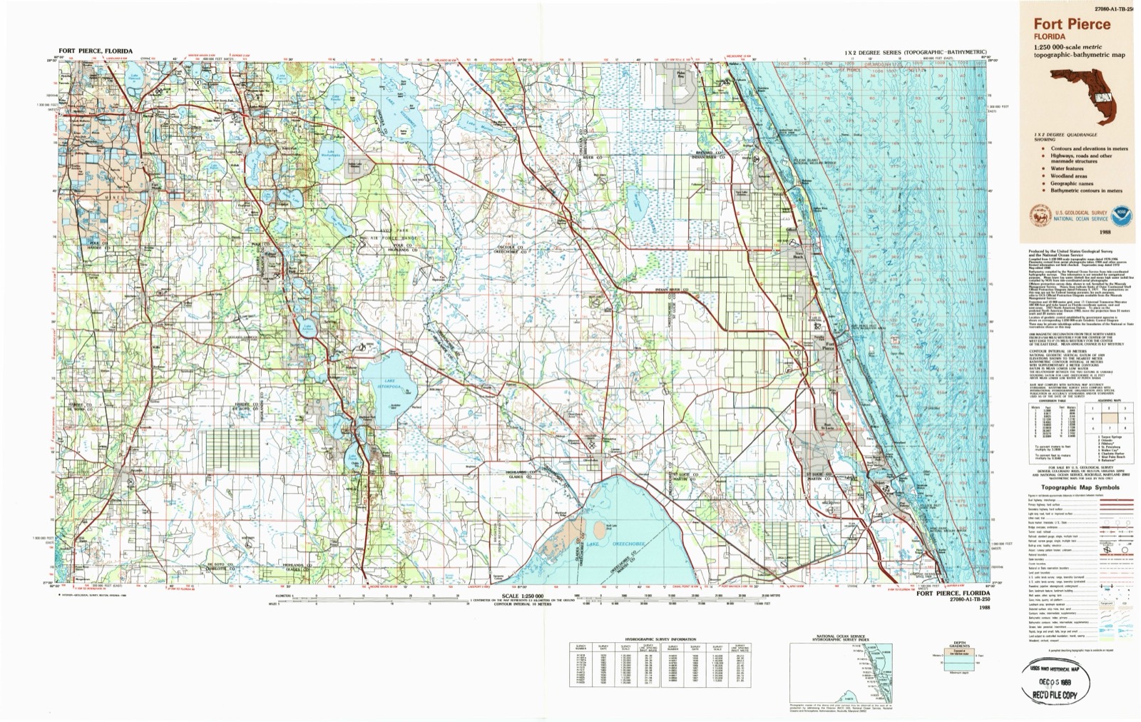
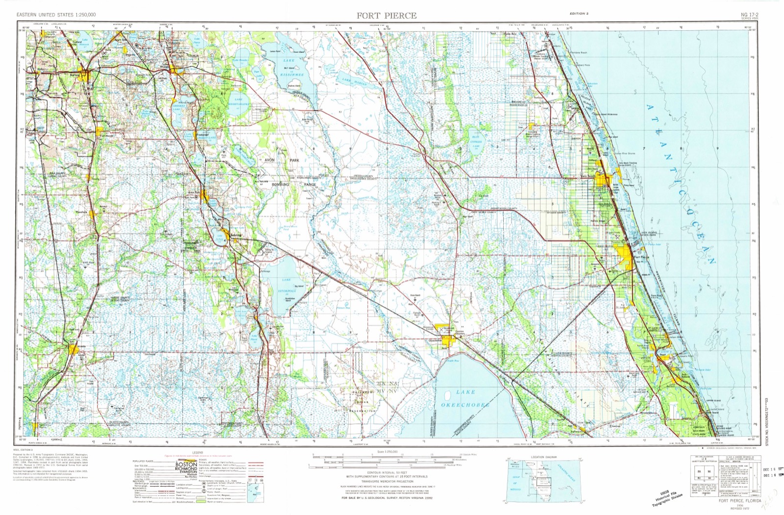
Regional context, not property-specific evidence. The federal wildfire occurrence database lists 217 fires within 5 miles of William Oswell Ralls House between 1992 and 2020, burning about 1,745 acres in total. 17 started naturally. 5 were recorded as arson. Distance is straight-line from the map coordinates, so a fire counted here may appear on a neighbouring settlement's page as well.
| Reported cause | Fires |
|---|---|
| Railroad operations and maintenance | 50 |
| Debris and open burning | 49 |
| Missing data/not specified/undetermined | 34 |
| Equipment and vehicle use | 25 |
| Natural | 17 |
| Recreation and ceremony | 16 |
| Misuse of fire by a minor | 12 |
| Arson/incendiarism | 5 |
| Power generation/transmission/distribution | 4 |
| Smoking | 4 |
| Other causes | 1 |
The most recent of them, most recent first, with the day each was reported and the service that recorded it.
| Date | Cause | Size | Reported by | Name on the report |
|---|---|---|---|---|
| 19 September 2011 | Missing data/not specified/undetermined | under an acre | Florida Forest Service | FEEDBAG (14) |
| 19 September 2005 | Missing data/not specified/undetermined | 1.0 acres | Florida Forest Service | 14-BULLDOG FIRE-0448 |
| 15 September 2005 | Debris and open burning | under an acre | Florida Forest Service | 14-WINDY PINE FIRE-0439 |
| 10 September 2008 | Natural | 2.0 acres | Florida Forest Service | 14-HANSEL AVENUE FIRE-0368 |
| 30 August 1997 | Railroad operations and maintenance | under an acre | Florida Forest Service | not named |
| 10 August 1993 | Natural | under an acre | Florida Forest Service | not named |
| 5 July 1998 | Natural | under an acre | Florida Forest Service | not named |
| 26 July 2007 | Debris and open burning | under an acre | Florida Forest Service | 14-PASSERBY FIRE-0428 |
Regional context, not property-specific evidence. The federal mineral resources record lists 5 workings within 5 miles of William Oswell Ralls House: 4 unknowns, 1 occurrence. None of them still produces. What was taken out: Sand, Phosphorus-Phosphates, Water, Free. Distance is straight-line from the map coordinates, so a quarry counted here may appear on a neighbouring settlement's page as well.
| Where | Site | Commodity | Status | Recorded |
|---|---|---|---|---|
| De Soto County Unknown Ownerships | Phosphorus-Phosphates, Water, Free | Occurrence | ||
| Dot Arcadia - Nocatee #1 Mine | Sand | Unknown | Sand | |
| Dot Arcadia - Nocatee #2 Mine | Sand | Unknown | Sand | |
| Dot Arcadia - Nocatee #3 Mine | Sand | Unknown | Sand | |
| Ghc Construction, Inc. - Hillsborough Mine | Sand | Unknown |
Regional context, not property-specific evidence. The National Weather Service names Arcadia, the town this property stands in, in 73 storm reports between 1993 and 2013: 24 thunderstorm wind, 23 flood, 12 hail, 8 tornado. The reports record 1 death. Each account below is quoted exactly as the forecast office filed it, from the NOAA Storm Events Database, and each date opens the federal record of that event.
| When | Event | Place named | Harm | What the report says |
|---|---|---|---|---|
| June 1996 | Lightning | Arcadia | 1 killed | no account filed |
| March 1998 | Flood | Arcadia | $3,800,000 | The Peace River along State Road 70 in Arcadia crested at 18.14 feet on the 23rd, over seven feet above the flood stage of eleven feet. Nearly 150 homes and recreational vehicles incurred water damage from the floodwaters, primarily in the Arcadia Peace River Campground. Water from the Peace River covered and closed State Road 64 while 35 additional secondary roads were closed in the vicinity of the river. Several roads and bridges along the Peace River and its tributaries were washed out or heavily damaged. |
| March 1998 | Flood | Arcadia | $1,000,000 | The Horse Creek at Arcadia crested at 16.22 feet, over four feet above its flood stage of twelve feet, on the 22nd. The floodwaters damaged several homes in the Hidden Acres subdivision and a portion of State Road 72 was underwater at Horse Creek. |
| February 1998 | Flood | Arcadia | $500,000 | The Peace River along State Road 70 in Arcadia crested at 16.0 feet on the 16th, over five feet above the flood stage of eleven feet. |
| November 1997 | Flash Flood | Arcadia | $380,000 | no account filed |
| June 2003 | Flash Flood | Arcadia | $200,000 | Flash Flooding in the western third of Desoto County closed and damaged back roads. Several homes received water damage from rising waters. Rainfall of 11.79 occurred 10 miles west of Arcadia during the last three days. |
| January 1998 | Flood | Arcadia | $200,000 | The Peace River along State Road 70 in Arcadia crested at 13.7 feet on the 28th, nearly three feet above the flood stage of 11 feet. A few homes along the banks of the Peace River received minor flood damage. |
| November 1997 | Flood | Arcadia | $115,000 | no account filed |
| January 1998 | Flood | Arcadia | $100,000 | The Horse Creek crested at 13.3 feet, nearly one and a half feet above the flood stage of twelve feet, on the 24th. A few homes in the Hidden Acres subdivision received minor flood damage. |
| June 1997 | Thunderstorm Wind | Arcadia | $100,000 | Thunderstorm winds damaged a boat shed on the northwest side of Arcadia then severely damaged the roofs of two businesses on the north side of Arcadia. Numerous trees and power lines were downed by thunderstorm winds on the north and east side of Arcadia. |
| February 1998 | Flood | Arcadia | $50,000 | The Horse Creek crested at 15.0 feet, three feet above the flood stage of twelve feet, on the 19th. A few homes in the Hidden Acres subdivision received minor to moderate flood damage. |
| December 1997 | Flood | Arcadia | $50,000 | The Peace River in Arcadia crested at 13.0 feet, two feet above flood stage, and flooded a few homes in Arcadia. |
| December 1997 | Flood | Arcadia | $30,000 | The Peace River along State Road 70 in Arcadia crested at 14.7 feet, nearly three and a half feet above the flood stage of eleven feet, on the 18th. Six homes along the banks of the Peace River received minor flood damage. |
| June 2001 | Thunderstorm Wind | Arcadia | $25,000 | The public reported, through WTVT-TV and WFTS-TV of Tampa, that thunderstorm winds caused damage to a mobile home, downed a few large trees and broke windows near the intersection of Pine Hurst and Eucalyptus Roads, four miles west of Arcadia. |
| March 1998 | Flood | Arcadia | $25,000 | The Peace River along State Road 70 in Arcadia crested at 12.6 feet on the 1st, over one and a half feet above the flood stage of 11 feet. |
| September 2000 | Flash Flood | Arcadia | $25,000 | no account filed |
| March 1998 | Flood | Arcadia | $20,000 | The Peace River along State Road 70 in Arcadia crested at 11.62 feet on the 11th, over a half foot above the flood stage of eleven feet. |
| January 1999 | Thunderstorm Wind | Arcadia | $15,000 | Thunderstorm winds tore off the roof of a home along Cherry Road and downed several trees and power lines throughout Arcadia. |
| June 2004 | Thunderstorm Wind | Arcadia | $10,000 | Several large trees were down, with one tree down on a house. |
| September 1998 | Flood | Arcadia | $10,000 | The Peace River along State Road 70 in Arcadia reached a height of 12.7 feet, more than a foot and a half above the flood stage of eleven feet, on the 30th. A few homes were damaged by floodwaters of the Peace River. |
| June 1998 | Thunderstorm Wind | Arcadia | $10,000 | Thunderstorm winds blew off the metal roof of a home on the 2800 block of Northeast Washington Street in Arcadia. |
| April 1998 | Flood | Arcadia | $10,000 | The Peace River along State Road 70 in Arcadia crested at 12.0 feet on the 1st, one foot above the flood stage of eleven feet. |
| October 1998 | Flood | Arcadia | $10,000 | The Peace River along State Road 70 in Arcadia reached a height of 12.8 feet, more than a foot and a half above the flood stage of eleven feet, on the 2nd. A few homes were damaged by floodwaters of the Peace River. |
| December 1997 | Flood | Arcadia | $10,000 | The Peace River along State Road 70 in Arcadia crested at 11.8 feet, nearly a foot above the flood stage of eleven feet, on the 31st. |
| December 1997 | Flood | Arcadia | $10,000 | The Horse Creek crested at 14.4 feet, near two and a half feet above the flood stage of of twelve feet, on the 16th. A few homes in the Hidden acres subdivision received minor flood damage. |
| September 1997 | Flood | Arcadia | $10,000 | no account filed |
| May 2001 | Thunderstorm Wind | Arcadia | $5,000 | Thunderstorm winds, estimated at 50 mph, removed a large portion of a tin roof from a weathered mobile home in Arcadia. |
| July 2000 | Thunderstorm Wind | Arcadia | $5,000 | A Skywarn Spotter reported that thunderstorm winds downed a few large trees, several branches and power lines in Arcadia. |
| May 1999 | Thunderstorm Wind | Arcadia | $5,000 | The De Soto county sheriffs office reported that thunderstorm winds downed a few large trees and several power lines in northwest Arcadia. |
| September 1998 | Tornado (F0) | Arcadia | $5,000 | The De Soto County Emergency Management reported that a weak tornado, associated with an outer band of Hurricane Georges, sporadically touched down along a narrow path and toppled a few trees and branches before it lifted and dissipated. |
| July 1998 | Thunderstorm Wind | Arcadia | $5,000 | A downburst removed a large portion of the roof of a home at the corner of Garvin and Horshoe Roads in Arcadia. |
| February 1998 | Flood | Arcadia | $5,000 | The Peace River along State Road 70 in Arcadia crested at 11.6 feet on the 1st, over one half foot above the flood stage of 11 feet. |
| September 1997 | Thunderstorm Wind | Arcadia | $5,000 | Thunderstorm winds of 45 to 50 mph partially removed the light weight roof of a home on Windy Pine Avenue in Arcadia. |
| February 1993 | Tornado (F0) | Arcadia | $5,000 | A small tornado knocked down many trees, one of which fell onto and damaged a mobile home west of Arcadia. |
| February 1993 | Thunderstorm Wind | Arcadia | $5,000 | Strong thunderstorm winds broke a plam tree in half in Arcadia and blew the roof off a shed in the eastern part of the county. |
| January 1998 | Flood | Arcadia | $4,000 | The Peace River along State Road 70 in Arcadia crested at 11.5 feet on the 1st, one half foot above the flood stage of 11 feet. |
| August 1995 | Thunderstorm Wind | Arcadia | $4,000 | Thunderstorm winds blew the roofs off of two mobile homes and downed a small rooftop TV antenna near State Road 31 Apache Road. |
| April 1997 | Thunderstorm Wind | Arcadia | $3,000 | Thunderstorm winds downed powerlines and uprooted a few trees on County Road 760, Pasco Street and Genes Little Acre Road. |
| April 1997 | Thunderstorm Wind | Arcadia | $3,000 | Thunderstorm winds severely damaged a carport, downed a few trees and powerlines in Arcadia. |
| December 1997 | Thunderstorm Wind | Arcadia | $3,000 | Thunderstorm winds downed several large branches and a few power lines along State Road 70 in Arcadia. |
| July 1998 | Flood | Arcadia | $2,000 | Three to six inches of heavy rain caused localized flooding of roadways over rural portions of western De Soto county from Arcadia west to the county line. |
| April 1997 | Tornado (F0) | Arcadia | $2,000 | A brief tornado touched down near the intersection of U.S. Highway 17 and State Road 70 in Arcadia with minimal damage. |
| April 1997 | Thunderstorm Wind | Arcadia | $2,000 | Thunderstorm winds downed a few trees and several large branches in Arcadia. |
| June 1997 | Tornado (F0) | Arcadia | $1,000 | A short-lived tornado downed a few trees in a pasture near Hansel Road two miles east of Arcadia. |
| May 1997 | Thunderstorm Wind | Arcadia | $1,000 | Thunderstorm wind toppled a large tree and a few power lines in the Hidden Acres subdivision. |
| April 1997 | Thunderstorm Wind | Arcadia | $1,000 | Thunderstorm winds downed several large tree limbs throughout Arcadia. |
| November 1997 | Thunderstorm Wind | Arcadia | $1,000 | Thunderstorm winds snapped two power poles in half on the ten thousand block of County Road 761 (Kings Highway). |
| October 1996 | Tornado (F0) | Arcadia | $1,000 | no account filed |
| January 1993 | Thunderstorm Wind | Arcadia | $500 | 60 mph thunderstorm gusts leveled trees. |
| May 2013 | Thunderstorm Wind | Arcadia | - | The 911 Call Center reported three trees and a large flagpole down in Arcadia. One tree was at SE Pointer Avenue south of Arcadia Municipal Airport, another tree was on SW Baldwin Street, and the third tree was on Parkview Road. The flagpole was knocked down on the corner of Polk Avenue and Magnolia Street. |
| August 2008 | Heavy Rain | Arcadia | - | A Southwest Florida Water Management District gauge recorded 7.10 inches of rain. |
| May 2007 | Hail | Arcadia | - | Penny size hail was observed near the intersection of Highway 70 and Highway 661. |
| May 2007 | Hail | Arcadia | - | Penny to quarter size hail covered the ground along parts of State Road 661. |
| April 2006 | Hail | Arcadia | - | Quarter size hail was reported by a trained spotter on Highway 72. The hail was partially covering the ground. |
| June 2006 | Tornado (F0) | Arcadia | - | Law enforcement reported a tornado. No significant damage was reported. |
| June 2006 | Tornado (F0) | Arcadia | - | Amateur radio reported a tornado north of Arcadia and the visible funnel extended three-quarters of the way to the ground. This tornado is from a different storm than the tornado south of Arcadia. No significant damage was reported. Path of tornado was estimated. |
| May 2005 | Hail | Arcadia | - | The hail covered the ground with 1 to 1.75 inch hail. |
| May 2000 | Wildfire | Arcadia | - | Lightning ignited and burned over 550 acres of scrub tree and brush at the Bright Hour Ranch east of Arcadia in De Soto county. |
| June 2000 | Hail | Arcadia | - | Skywarn Spotters reported dime sized hail from Arcadia to three miles southeast of Arcadia in De Soto county. |
| May 1999 | Hail | Arcadia | - | Dime sized hail was reported by Skywarn Spotters in Arcadia. |
United States Geological Survey topographic sheets whose coverage includes this point. Matched by taking the coordinate the National Park Service records for this property, then testing that coordinate against the published boundary of every sheet.
Other National Register properties close enough to walk or drive between, ordered by distance from this one. Both positions come from the same geocoding pass that matched these properties to their map sheets.
| Photograph | Property | Distance | Listed |
|---|---|---|---|
 | Micajah T. Singleton House | 0.2 miles | 2013 |
 | Arcadia Historic District | 0.5 miles | 1984 |
 | Johnson-Smith House | 1.3 miles | 2013 |
| National Archives record | The nomination case file for reference 11000001 in Record Group 79. |
| DeSoto County | All 4 listed properties in this county. |