BlockBefore
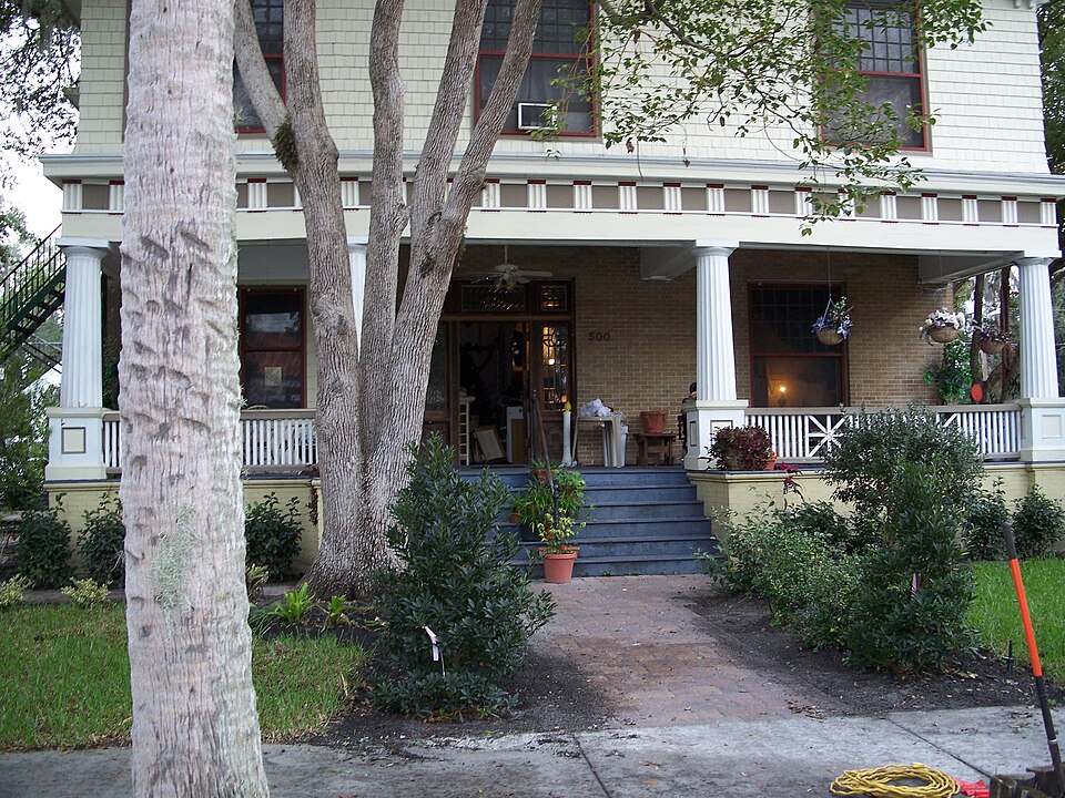
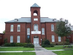
Photograph of Old Fernald-Laughton Memorial Hospital
Photograph by Ebyabe, CC BY 2.5. Via Wikimedia Commons.

Old Fernald-Laughton Memorial Hospital

Listed on the National Register of Historic Places in 1987. 6 historic topographic surveys show this location, the earliest from 1955.

From the record

“The Old Fernald-Laughton Memorial Hospital is a historic site in Sanford, Florida, United States. On May 21, 1987, it was added to the U.S.”

Wikipedia article Old Fernald-Laughton Memorial Hospital, CC BY-SA 4.0.

One of 19 National Register listings published here for Seminole County · listed in 1987 · category: Building.

Sources: the Wikipedia article · the case file at the National Archives · the National Register database, National Park Service

The listing

  • What is counted as historic. The nomination lists 1 building as contributing to the listing.
  • Listed as. Old Fernald--Laughton Memorial Hospital - the National Register files a house under its owner's surname.
  • Address. 500 S. Oak Ave., Sanford, 32771
  • When was it listed? May 1987
  • Category. building
  • Census division. Sanford
  • Architectural style. Colonial Revival architecture
  • National Register reference number. 87000805 - the number the National Park Service assigned this property when it was listed, and the key its nomination file is catalogued under at the National Archives.

Fires near this property

73 since 1992

Regional context, not property-specific evidence. The federal wildfire occurrence database lists 73 fires within 5 miles of Old Fernald-Laughton Memorial Hospital between 1992 and 2020, burning about 398 acres in total. 8 started naturally. 9 were recorded as arson. Distance is straight-line from the map coordinates, so a fire counted here may appear on a neighbouring settlement's page as well.

Reported cause Fires
Railroad operations and maintenance27
Missing data/not specified/undetermined10
Arson/incendiarism9
Natural8
Debris and open burning7
Equipment and vehicle use5
Misuse of fire by a minor4
Recreation and ceremony2
Smoking1

The most recent of them, most recent first, with the day each was reported and the service that recorded it.

DateCause SizeReported by Name on the report
2 September 1999Equipment and vehicle useunder an acreFlorida Forest Servicenot named
8 August 2006Misuse of fire by a minorunder an acreFlorida Forest ServiceWF-STONE ISLAND ROAD
5 August 2006Naturalunder an acreFlorida Forest ServiceWF- LINCOLN
26 August 2002Naturalunder an acreFlorida Forest Servicenot named
19 August 1993Railroad operations and maintenance2.0 acresFlorida Forest Servicenot named
13 August 2008Missing data/not specified/undeterminedunder an acreFlorida Forest ServiceOUT THERE (03)
7 July 2016Natural14 acresFlorida Forest ServiceLAKE MONROE 415 (64)
28 July 2009Naturalunder an acreFlorida Forest ServiceWF ENTERPRISE RD

Every fire recorded in Seminole County

Mines and quarries near this property

5 within 5 miles

Regional context, not property-specific evidence. The federal mineral resources record lists 5 workings within 5 miles of Old Fernald-Laughton Memorial Hospital: 4 unknowns, 1 producer. 1 still produces. What was taken out: Sand, Clay. Distance is straight-line from the map coordinates, so a quarry counted here may appear on a neighbouring settlement's page as well.

Every working recorded in Seminole County

Storms near this property

29 since 1993

Regional context, not property-specific evidence. The National Weather Service names Sanford, the town this property stands in, in 29 storm reports between 1993 and 2021: 17 thunderstorm wind, 7 hail, 2 flash flood, 1 lightning. The reports record 1 death and 4 injuries. Each account below is quoted exactly as the forecast office filed it, from the NOAA Storm Events Database, and each date opens the federal record of that event.

WhenEvent Place namedHarm What the report says
October 2018Thunderstorm WindSanford1 killed, 1 hurtThe large circulation around Hurricane Michael located near the western tip of Cuba combined with high pressure to the north caused quick-moving showers with gusty winds to move west across central Florida from the Atlantic. As these showers moved over inland lakes, wind gusts of 30 to 40 mph occurred. A boat containing two men who were fishing on Lake Monroe capsized due to choppy seas created by the gusty winds. One man, who was wearing a non-secured life vest, drifted away from the boat and was found deceased the following day. The other man retrieved his lift vest while hanging onto the side of the boat and was rescued nearly 24 hours later. He was transported to a local hospital, suffering from hypothermia and exhaustion and was later released.
August 1999Thunderstorm WindSanford2 hurt, $80,000Thunderstorm winds produced widespread damage along the marina area of Sanford. A hotel, several boats, dock houses, and an office building suffered damage. Two people were injured when their car windows were blown out.
August 1997LightningSanford1 hurtA 41 year old woman was injured by lightning while standing next to a window in a house.
February 1998Tornado (F0)Sanford$200,000A small F-0 tornado touched down in Sanford destroying the roof on a log cabin house.
August 2002Flash FloodSanford$60,000Three inches of rapid rainfall flooded streets and six homes in Sanford.
January 1999Thunderstorm WindSanford$50,000Thunderstorm winds blew down trees in the Sanford area. The fallen trees damaged two mobile homes and a house.
August 1997Thunderstorm WindSanford$45,000Thunderstorm winds blew a large tree on to a house causing extensive damage.
May 2001Thunderstorm WindSanford$5,000Thunderstorm winds blew down numerous trees and damaged pool screens.
March 1993Thunderstorm WindSanford$500Thunderstorm winds blew down trees and power lines.
September 2021Flash FloodSanford-Between 4 and 6 inches of rain fell during the late afternoon hours in portions of northern Seminole County. Heavy thunderstorms that were nearly stationary produced significant rainfall accumulations in approximately 2 hours, and this resulted in localized flash flooding in the Sanford area. Standing water reached at least 2 feet in some spots, resulting in numerous road closure and several stalled vehicles. Flood waters briefly entered one home and several nearby garages. Several businesses in Downtown Sanford along 1st Street reported having 2-3 inches of water inside their establishments.
May 2020HailSanford-A trained spotter reported penny sized hail in Downtown Sanford near the intersection of Magnolia Avenue and East First Street.
September 2017FloodSanford-Rainbands associated with Hurricane Irma produced rainfall totals between 10 and 13 inches, resulting in areas of urban and poor drainage flooding. Numerous roadways were impacted by significant levels of standing water and many retention ponds reached capacity or overflowed. The most impacted areas occurred within Altamonte Springs, Casselberry, Longwood and Sanford.
February 2014HailSanford-A retired NWS employee observed quarter-sized hail just west of Sanford.
May 2014HailSanford-An Orlando TV station relayed a report from the public of quarter-sized hail at the Sanford Memorial Stadium.
July 2006Thunderstorm WindSanford-Sanford airport recorded a thunderstorm wind gust to 58 MPH.
May 2005Thunderstorm WindSanford-The Sanford airport ASOS recorded a wind gust to 67 knots (76 mph).
June 2005Thunderstorm WindSanford-Thunderstorm winds blew down large branches and power lines in Sanford. Some minor street flooding was also reported.
August 2005Thunderstorm WindSanford-Thunderstorm winds blew down trees blocking Highway 46 just east of Sanford.
June 2004Thunderstorm WindSanford-Thunderstorm winds blew down trees and power lines in the Sanford area.
May 2004Thunderstorm WindSanford-Thunderstorm winds blew down power lines in Sanford.
March 2003Thunderstorm WindSanford-Thunderstorm winds blew down power lines and a large tree branch in Sanford. Sanford airport reported a wind gust to 54 mph.
June 2001Thunderstorm WindSanford-Thunderstorm wind blew down trees over much of Sanford and the Maitland areas.
May 1997Thunderstorm WindSanford-Thunderstorm winds blew down large signs and damaged a railroad crossing gate.
May 1997Thunderstorm WindSanford-Thunderstorm winds blew down a few trees in Sanford.
October 1997Thunderstorm WindSanford-Thunderstorm winds blew down trees near Sanford and power lines near Oviedo.
June 2004HailSanford-no account filed
July 2003HailSanford-no account filed
May 2001HailSanford-no account filed
June 1999HailSanford-no account filed

Every storm recorded in Seminole County

Maps showing this location

6 surveys

United States Geological Survey topographic sheets whose coverage includes this point. Matched by taking the coordinate the National Park Service records for this property, then testing that coordinate against the published boundary of every sheet.

Listed places nearby

6 within 8 miles

Other National Register properties close enough to walk or drive between, ordered by distance from this one. Both positions come from the same geocoding pass that matched these properties to their map sheets.

Photograph PropertyDistance Listed
Sanford Grammar School0.2 miles1984
Sanford Residential Historic District0.2 miles1989
Ritz Theater0.2 miles2001
Sanford Commercial District0.3 miles1976
St. James A. M. E. Church0.4 miles1992
Georgetown Historic District0.5 miles2020

Sources for this property

National Archives recordThe nomination case file for reference 87000805 in Record Group 79.
Wikipedia articleCommunity-written account of this property, licensed CC BY-SA.
Seminole CountyAll 19 listed properties in this county.

Provenance

  • Listing record. National Park Service National Register of Historic Places, listed-properties dataset, current to 2026-05-22.
  • Map join. Address geocoded through the United States Census geocoder, then tested against the published boundary of every sheet in the USGS Historical Topographic Map Collection.
  • How this page is made. Listing fields come from federal records; map-sheet coverage is a labelled coordinate-to-boundary calculation, not a source-field claim.
  • Wildfire. Short, Karen C. 2022. Spatial wildfire occurrence data for the United States, 1992-2020 [FPA_FOD_20221014]. 6th Edition. Fort Collins, CO: Forest Service Research Data Archive. https://doi.org/10.2737/RDS-2013-0009.6 Collected with United States Government funding and usable without additional permissions or fees.
  • Mines and quarries. USGS Mineral Resources Data System (MRDS) https://mrdata.usgs.gov/mrds/ A work of the United States government, no copyright under 17 U.S.C. 105.
  • Storms. NOAA National Centers for Environmental Information, Storm Events Database https://www.ncei.noaa.gov/stormevents/ A work of the United States government, no copyright under 17 U.S.C. 105. Narratives are quoted verbatim from the National Weather Service report and are not edited or summarised.