Listed on the National Register of Historic Places in 1998. 7 historic topographic surveys show this location, the earliest from 1956.
From the record
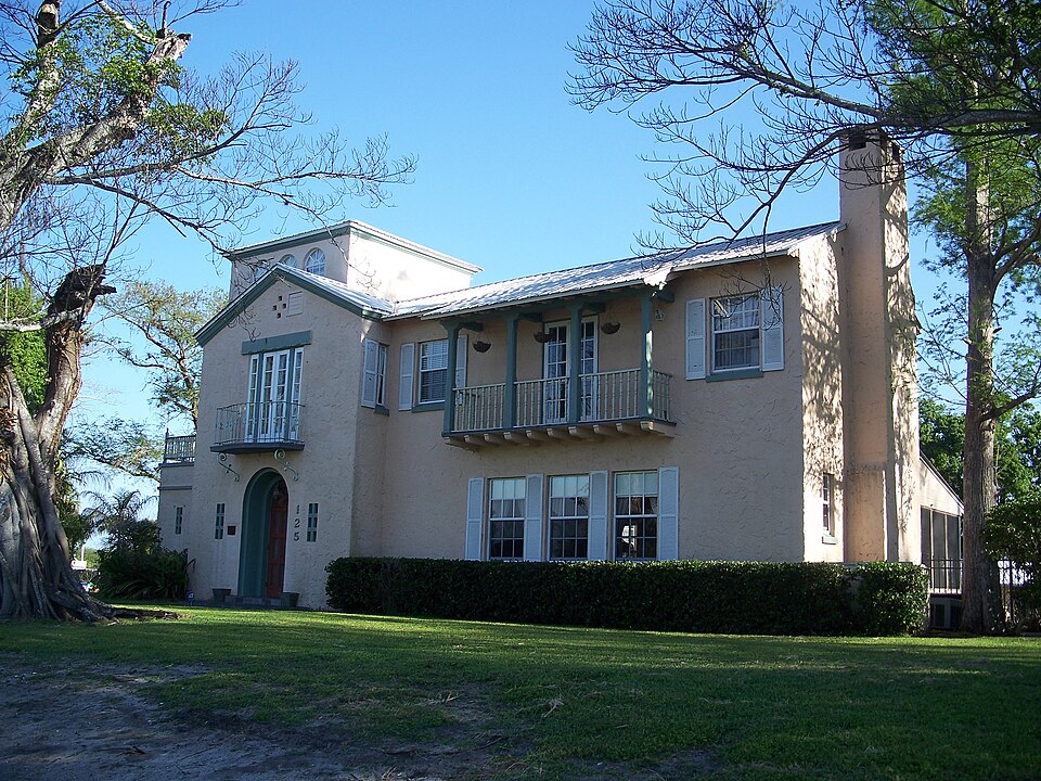
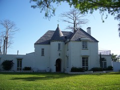
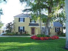
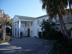
“The Executive House is a historic house located at 125 West Del Monte Avenue in Clewiston, Florida. The house is locally significant as a well preserved example of the Mediterranean Revival style in Clewiston and as a representative work of Palm Beach architect Clark J.”
Wikipedia article Executive House, CC BY-SA 4.0.
One of 12 National Register listings published here for Hendry County · listed in 1998 · category: Building.
National Register reference number.98000059- the number the National Park Service assigned this property when it was listed, and the key its nomination file is catalogued under at the National Archives.
Fires near this property
11 since 2001
Regional context, not property-specific
evidence. The
federal wildfire occurrence database
lists 11 fires within 5 miles of Executive House
between 2001 and 2019, burning about 79,226 acres in total. None started naturally. 2 were recorded as arson.
Distance is straight-line from the map coordinates, so a fire counted
here may appear on a neighbouring settlement's page as well.
Reported cause
Fires
Misuse of fire by a minor
2
Debris and open burning
2
Equipment and vehicle use
2
Missing data/not specified/undetermined
2
Arson/incendiarism
2
Railroad operations and maintenance
1
The most recent of
them, most recent first, with the day each was reported and the service
that recorded it.
Regional context, not property-specific
evidence. The federal mineral resources record lists
6 workings within 5 miles of Executive House: 5 producers, 1 past producer.
5 still produce. What was taken out: Sand, Stone, Crushed/Broken, Calcium. Distance is straight-line from the
map coordinates, so a quarry counted here may appear on a neighbouring
settlement's page as well.
Regional context, not property-specific
evidence. The National Weather Service names
Clewiston, the town this property stands in, in 28 storm reports between 1993 and 2023: 10 thunderstorm wind, 6 funnel cloud, 5 hail, 3 tornado.
The reports record 1 death and 4 injuries. Each account below is quoted exactly as the forecast office
filed it, from the NOAA Storm Events Database, and each date
opens the federal record of that event.
A 57 year old male died and his 56 year old friend was injured when their boat was struck by lightning on Lake Okeechobee. The two men were boating and decided to dock at the Clewiston boat ramps as a thunderstorm approached. As they were making their way back to Clewiston, lightning struck their boat and both men were knocked unconscious. Some time later, the 56 year old male awoke and called 911 after realizing what happened. Hendry County EMS arrived on the scene and transported the unconscious male to Hendry County Regional Medical Center where he was pronounced dead. The other male was later taken to Palms West Hospital to be treated for his injuries.
A tornado touched down near a mobile home park overturning two trailers and destroying another. A 70-foot trailer was flipped onto a car. Three people were injured in this trailer. Another trailer two blocks away was destroyed but its occupants fled just before it exploded.
Rainfall amounts ranged 7 to 10 inches over northern Collier, Hendry and Glades counties near the path of the center of Fay. Isolated areas in northeastern Hendry and southeastern Glades counties received well in excess of 10 inches, with Moore Haven recorded the highest storm total rainfall of 16.17 inches recorded in the 48-hour period ending at 8 AM on Wednesday, August 20th. Extensive flooding was observed over the areas with the highest totals, especially over Hendry and Glades counties. Hardest hit areas were the Felda and Montura areas in Hendry County were maximum rainfall amounts ranged from around 10 inches in Felda to as much as 12 to 15 inches in the Montura area.
The Hendry County Emergency Manager reported wind damage to private and public property in Clewiston due to a severe thunderstorm. Damage included a roof collapse at Clewiston Nursing and Rehabilitation Center, and downed large tree branches.
A long-track supercell tornado, associated with a rainband of Hurricane Charley, moved across the open Everglades before striking a building in Clewiston.
A severe thunderstorm moved ESE over Clewiston, producing damage along an approximately half-mile long path. First indication of damage was at the intersection of Berner Road and US 27 where a shed was blown onto the edge of the roadway, power lines were downed, and shopping carts were tossed into cars at the Sugarland Plaza. Farther to the ESE along W. Ventura Avenue, a window was broken at a nursing and rehab center, 2 downed large tree branches, and a carport cover was blown into the front yard of a home. A large tree branch was downed along Gloria Street next to Hendry Regional Medical Center. The final damage location was along W. Alverdez Avenue where roof siding was blown into the front yards of 2 homes. ||Damage amounts are estimated, along with the time.
Broadcast meteorologist and county emergency managers reported several trees down and fence damage in Clewiston in the area near Clewiston Middle School and extending south to Sykes Park.
Hendry County Sheriff's Office reported minor damage across portions of Clewiston. Damage occurred to a residential shed and fence along with several uprooted trees and a trampoline thrown against a house near Georgia Ave and 7th Street. Additional uprooted trees led to minor roof damage and fence at Clewiston Middle School.
A member of the public reported 3 funnel clouds just north of Clewiston. All 3 funnels lowered about halfway to the surface then retreated back into the clouds.
United States Geological Survey topographic
sheets whose coverage includes this point. Matched by taking the coordinate the National Park Service records for this property, then
testing that coordinate against the published boundary of every sheet.
Other National Register properties close
enough to walk or drive between, ordered by distance from this one. Both
positions come from the same geocoding pass that matched these properties
to their map sheets.
Listing record. National Park Service National Register of Historic Places, listed-properties dataset, current to 2026-05-22.
Map join. Address geocoded through the United States Census geocoder, then tested against the published boundary of every sheet in the USGS Historical Topographic Map Collection.
How this page is made. Listing fields come from federal records; map-sheet coverage is a labelled coordinate-to-boundary calculation, not a source-field claim.
Wildfire. Short, Karen C. 2022. Spatial wildfire occurrence data for the United States, 1992-2020 [FPA_FOD_20221014]. 6th Edition. Fort Collins, CO: Forest Service Research Data Archive. https://doi.org/10.2737/RDS-2013-0009.6 Collected with United States Government funding and usable without additional permissions or fees.
Mines and quarries. USGS Mineral Resources Data System (MRDS) https://mrdata.usgs.gov/mrds/ A work of the United States government, no copyright under 17 U.S.C. 105.
Storms. NOAA National Centers for Environmental Information, Storm Events Database https://www.ncei.noaa.gov/stormevents/ A work of the United States government, no copyright under 17 U.S.C. 105. Narratives are quoted verbatim from the National Weather Service report and are not edited or summarised.
 Block
Block