
BlockBefore
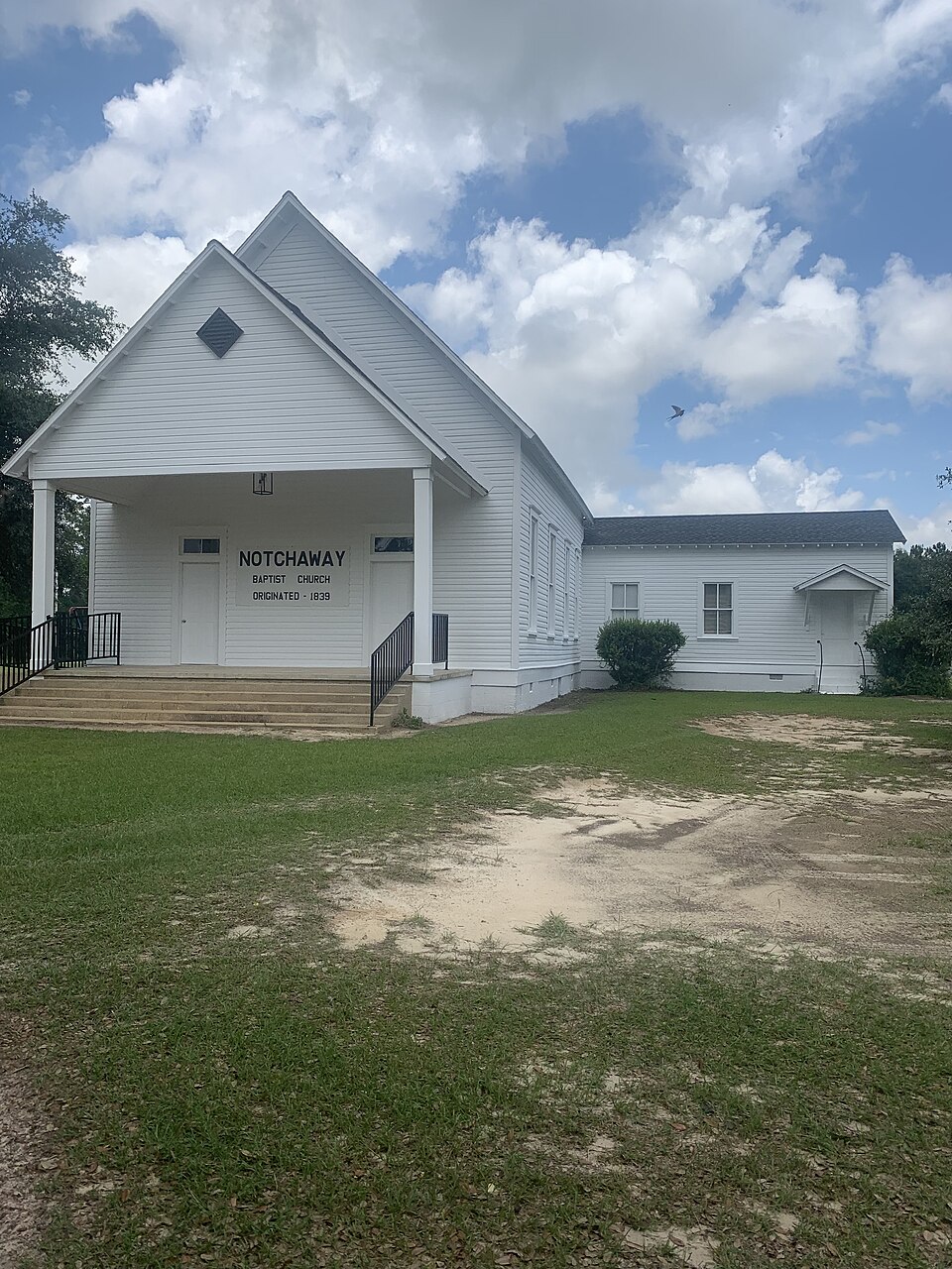
Photograph of Notchaway Baptist Church and Cemetery
Photograph by Justshea, CC BY-SA 4.0. Via Wikimedia Commons.

Notchaway Baptist Church and Cemetery

Listed on the National Register of Historic Places in 2001.

From the record

“Notchaway Baptist Church and Cemetery is a historic church and cemetery located southwest of Newton, Georgia on Georgia Highway 91. It was added to the National Register of Historic Places on May 25, 2001.”

Wikipedia article Notchaway Baptist Church and Cemetery, CC BY-SA 4.0.

One of 4 National Register listings published here for Baker County · listed in 2001 · category: Building.

Sources: the Wikipedia article · the case file at the National Archives · the National Register database, National Park Service

The listing

  • What is counted as historic. The nomination lists 1 building, 1 site as contributing to the listing.
  • Address. Jct. of GA 91 amd GA 253, Newton, 39837
  • When was it listed? May 2001
  • Category. building
  • Census division. Milford
  • National Register reference number. 01000534 - the number the National Park Service assigned this property when it was listed, and the key its nomination file is catalogued under at the National Archives.

Fires near this property

163 since 1992

Regional context, not property-specific evidence. The federal wildfire occurrence database lists 163 fires within 5 miles of Notchaway Baptist Church and Cemetery between 1992 and 2020, burning about 1,222 acres in total. 4 started naturally. 11 were recorded as arson. Distance is straight-line from the map coordinates, so a fire counted here may appear on a neighbouring settlement's page as well.

Reported cause Fires
Debris and open burning111
Equipment and vehicle use17
Missing data/not specified/undetermined12
Arson/incendiarism11
Smoking6
Natural4
Recreation and ceremony1
Misuse of fire by a minor1

The most recent of them, most recent first, with the day each was reported and the service that recorded it.

DateCause SizeReported by Name on the report
5 September 2005Equipment and vehicle useunder an acreGeorgia Forestry Commissionnot named
13 September 2005Debris and open burning1.0 acresGeorgia Forestry Commissionnot named
13 September 1999Debris and open burning2.8 acresGeorgia Forestry Commissionnot named
6 August 2014Debris and open burningunder an acreGeorgia Forestry CommissionFY2015-MILLER-002
6 August 2010Naturalunder an acreGeorgia Forestry CommissionFY2011-MILLER-003
23 July 2007Missing data/not specified/undetermined3.5 acresGeorgia Forestry Commissionnot named
17 July 2000Natural49 acresGeorgia Forestry CommissionFY2001-MILLER-006
13 July 2006Equipment and vehicle useunder an acreGeorgia Forestry Commissionnot named

Every fire recorded in Baker County

Storms near this property

26 since 1994

Regional context, not property-specific evidence. The National Weather Service names Newton, the town this property stands in, in 26 storm reports between 1994 and 2026: 18 thunderstorm wind, 3 hail, 3 tornado, 1 flash flood. The reports record 6 deaths and 3 injuries. Each account below is quoted exactly as the forecast office filed it, from the NOAA Storm Events Database, and each date opens the federal record of that event.

WhenEvent Place namedHarm What the report says
March 2007Tornado (EF2)Newton6 killed, 3 hurt, $1,250,000An EF-2 tornado touched down in rural Baker County west of Newton, then traveled rapidly northeast, and caused extensive damage to a mobile home park a mile north of Newton. Six people died and three were injured when their mobile homes were demolished by the tornado. A church was destroyed on State Highway 37 a few miles west of Newton. GEMA and FEMA damage assessments determined ten minor damaged homes, nine major damaged homes, and 18 destroyed homes. The tornado crossed into northern Mitchell County north of Baconton. A state of emergency was declared by the Governor.
April 2009FloodNewton$500,000Minor to moderate flooding along the Flint River flooded several homes. Highway 200 in Newton was closed. Water surrounded the courthouse and three vacant buildings. The river crested at 32 feet on April 5.
August 2008Flash FloodNewton$150,000Several roads and low lying areas were flooded, including portions of Newton, and State Highways 37 and 91.
January 2017Thunderstorm WindNewton$50,000There was significant damage to trees and a few structures in the town of Newton. A survey determined that the damage was consistent with straight line winds near 85 mph. Damage cost was estimated.
January 2013Tornado (EF0)Newton$15,000A Baker county fire chief reported a damage swath starting near the intersection of Highway 200 and Highway 37 where a house sustained minor damage, extending northeastward around 1 mile through portions of Newton where trees were snapped or twisted. The damage was consistent with an EF0 tornado with winds of 70-80 mph and also corresponded to an area of rotation on radar. Monetary damage was estimated.
December 2019Tornado (EF0)Newton$10,000The initial touchdown occurred north of Church road in Baker county where several trees and large limbs were snapped. The tornado moved northeast near a mobile home which received roof damage and the entire structure was slid off its support roughly 3 feet, as well as damaged an irrigation pivot. The tornado dissipated just west of Coon Pond Road. Max winds were estimated at 70 mph. Damage cost was estimated.
August 2012Thunderstorm WindNewton$5,000Multiple trees were blown down along highway 37 with multiple trees and power lines down along Highway 200 near Newton. Monetary damage was estimated.
September 2011Thunderstorm WindNewton$4,000Trees were blown down around the county. The monetary damage figure provided is a rough estimate.
April 2015Thunderstorm WindNewton$3,000Several trees and power lines were blown down.
April 2021Thunderstorm WindNewton$2,000Trees and power lines were blown down.
December 2019Thunderstorm WindNewton$2,000Multiple trees and power lines were blown down.
March 2014Thunderstorm WindNewton$1,000A tree was blown down on Coone Pond Road.
July 2012Thunderstorm WindNewton$1,000A tree was blown down in Newton. Monetary damage was estimated.
August 2014Thunderstorm WindNewton$500A tree was blown down onto Clear Lake Road.
June 1994Thunderstorm WindNewton$500A few large trees and power lines were downed by thunderstorm winds in Newton.
July 1994Thunderstorm WindNewton$500Thunderstorm winds downed numerous tree limbs across county roads 8 miles east of Newton.
August 1994Thunderstorm WindNewton$500Mitchell Electric reported numerous trees were blown down onto powerlines along Georgia Highway 200 in Newton.
June 1997Thunderstorm WindNewton$100no account filed
January 2026Thunderstorm WindNewton-Tree damage was reported in Newton including one large pine tree uprooted.
July 2023Thunderstorm WindNewton-A tree was blown down along Highway 91.
August 2022Thunderstorm WindNewton-A tree was blown down on Highway 37 about 3 miles from Newton.
February 2020Thunderstorm WindNewton-Scattered trees were blown down in Baker county.
May 1995Thunderstorm WindNewton-Thunderstorm winds knocked numerous large trees down along Georgia Highway 200.
April 2021HailNewton-no account filed
May 2012HailNewton-no account filed
September 1996HailNewton-no account filed

Every storm recorded in Baker County

Map coverage status

No historic map-sheet match is published for this property yet. That does not mean no map exists. This record needs a coordinate-quality review before it can be joined to a sheet boundary. Browse the county's mapped places while that work is pending.

Sources for this property

National Archives recordThe nomination case file for reference 01000534 in Record Group 79.
Wikipedia articleCommunity-written account of this property, licensed CC BY-SA.
Baker CountyAll 4 listed properties in this county.

Provenance

  • Listing record. National Park Service National Register of Historic Places, listed-properties dataset, current to 2026-05-22.
  • Map join. Address geocoded through the United States Census geocoder, then tested against the published boundary of every sheet in the USGS Historical Topographic Map Collection.
  • How this page is made. Listing fields come from federal records; map-sheet coverage is a labelled coordinate-to-boundary calculation, not a source-field claim.
  • Wildfire. Short, Karen C. 2022. Spatial wildfire occurrence data for the United States, 1992-2020 [FPA_FOD_20221014]. 6th Edition. Fort Collins, CO: Forest Service Research Data Archive. https://doi.org/10.2737/RDS-2013-0009.6 Collected with United States Government funding and usable without additional permissions or fees.
  • Storms. NOAA National Centers for Environmental Information, Storm Events Database https://www.ncei.noaa.gov/stormevents/ A work of the United States government, no copyright under 17 U.S.C. 105. Narratives are quoted verbatim from the National Weather Service report and are not edited or summarised.