 Block
From the record
One of 9 National Register listings published here for Murray County · listed in 2005 · category: District.
Sources: the case file at the National Archives · the National Register database, National Park Service
Listed on the National Register of Historic Places in 2005.
One of 9 National Register listings published here for Murray County · listed in 2005 · category: District.
Sources: the case file at the National Archives · the National Register database, National Park Service
Regional context, not property-specific evidence. The federal wildfire occurrence database lists 515 fires within 5 miles of Chatsworth Downtown Historic District between 1992 and 2020, burning about 1,336 acres in total. 9 started naturally. 75 were recorded as arson. Distance is straight-line from the map coordinates, so a fire counted here may appear on a neighbouring settlement's page as well.
| Reported cause | Fires |
|---|---|
| Debris and open burning | 269 |
| Arson/incendiarism | 75 |
| Missing data/not specified/undetermined | 67 |
| Misuse of fire by a minor | 54 |
| Recreation and ceremony | 12 |
| Equipment and vehicle use | 12 |
| Natural | 9 |
| Railroad operations and maintenance | 8 |
| Smoking | 7 |
| Power generation/transmission/distribution | 1 |
| Fireworks | 1 |
The most recent of them, most recent first, with the day each was reported and the service that recorded it.
| Date | Cause | Size | Reported by | Name on the report |
|---|---|---|---|---|
| 9 September 1998 | Debris and open burning | under an acre | Georgia Forestry Commission | not named |
| 9 September 1998 | Missing data/not specified/undetermined | under an acre | Georgia Forestry Commission | not named |
| 8 September 1993 | Arson/incendiarism | under an acre | Georgia Forestry Commission | not named |
| 7 September 2007 | Debris and open burning | 6.2 acres | Georgia Forestry Commission | not named |
| 6 September 1993 | Arson/incendiarism | under an acre | Georgia Forestry Commission | not named |
| 5 September 1999 | Arson/incendiarism | under an acre | Georgia Forestry Commission | not named |
| 4 September 2002 | Debris and open burning | 2.5 acres | Georgia Forestry Commission | FY2003-MURRAY-011 |
| 4 September 1999 | Misuse of fire by a minor | under an acre | Georgia Forestry Commission | not named |
Regional context, not property-specific evidence. The federal mineral resources record lists 39 workings within 5 miles of Chatsworth Downtown Historic District: 25 past producers, 7 prospects, 4 producers, 3 occurrences. 4 still produce. What was taken out: Talc-Soapstone, Iron, Stone, Crushed/Broken, Barium-Barite. Distance is straight-line from the map coordinates, so a quarry counted here may appear on a neighbouring settlement's page as well.
| Where | Site | Commodity | Status | Recorded |
|---|---|---|---|---|
| Earnest Galena Prospect | Lead | Prospect | ||
| J.F.Love Property | Iron, Manganese | Prospect | ||
| C.C.Keith Property | Barium-Barite | Past Producer | ||
| W.F.Hampton Property | Barium-Barite | Occurrence | ||
| Chatsworth Mine | Stone, Crushed/Broken | Producer | ||
| Farrar Tripoli Prospect | Stone, Crushed/Broken | Prospect | ||
| Fort Mountain Stone Quarry | Stone, Crushed/Broken | Past Producer | ||
| Hayes Rock Mine | Stone, Crushed/Broken | Past Producer | ||
| Southern Talc Slate Pit | Stone, Crushed/Broken | Past Producer | ||
| C.C. and J.H. Keith Property | Iron | Past Producer |
Regional context, not property-specific evidence. The National Weather Service names Chatsworth, the town this property stands in, in 49 storm reports between 1993 and 2024: 22 thunderstorm wind, 17 hail, 5 lightning, 2 tornado. The reports record 4 injuries. Each account below is quoted exactly as the forecast office filed it, from the NOAA Storm Events Database, and each date opens the federal record of that event.
| When | Event | Place named | Harm | What the report says |
|---|---|---|---|---|
| April 1997 | Tornado (F0) | Chatsworth | 3 hurt, $100,000 | no account filed |
| April 1993 | Thunderstorm Wind | Chatsworth | 1 hurt, $5,000 | Thunderstorm winds downed several large trees and downed power lines along Georgia Highway 225. One man was injured from wind blown debris. |
| June 1994 | Tornado (F1) | Chatsworth | $500,000 | A brief tornado touched down and severely damaged a carpet mill on Duvall Road. The carpet mill had its roof removed and one wall blown down which caused approximately 100,000 dollars worth of damage.,, |
| September 2009 | Lightning | Chatsworth | $250,000 | The Daily Citizen of Dalton reported that lightning struck and set the Rock Building on fire. This was the site of the first high school in Murray County. The building was completely destroyed from the fire. |
| April 2006 | Hail | Chatsworth | $200,000 | Numerous reports of hail ranging in size from pennies to quarters were received from the public from Chatsworth, Eton, and north of Ramhurst. One report of golf ball-sized hail was received from the public in Chatsworth. In addition, an amateur radio operator reported nickel-sized hail near Eton and estimated wind gusts at 66 mph. |
| July 2004 | Thunderstorm Wind | Chatsworth | $100,000 | The Daily Citizen of Dalton reported significant damage to trees and power lines in the Chatsworth area from thunderstorm winds. At one residence, nine trees were blown down, one causing minor damage to the roof. Another tree fell across the Mason apartments on Mount Carmel Road. Part of the tree went through the kitchen of one of the apartments. The tree also caused damage to the roof and other structural damage to the building. Two families were forced to relocate as a result of the damage. The strong winds and downed trees also knocked a power pole adjacent to the building down onto the apartments. Elsewhere in the county, at least eight roads were blocked by downed trees. |
| June 2002 | Thunderstorm Wind | Chatsworth | $50,000 | The Daily Citizen newspaper of Dalton reported that numerous trees and power lines were blown down across the southern portions of the county. In addition, a tree fell on a trailer home and a limb fell on a pickup truck on Georgia Highway 52. Approximately 1000 residences were left without power much of the evening and about 100 remained without power well into the next day. Consequently, several businesses were forced to close for the next day. Power crews had difficulty restoring power to some locations because of tree debris blocking roads. |
| March 2010 | Hail | Chatsworth | $45,000 | The public observed golf ball-sized hail near Eton and quarter-sized hail west of Chatsworth. Radar data suggests that at least quarter-sized hail continued east to northeast of Eton to near Conasauga Lake on the eastern border of the county. |
| July 2004 | Lightning | Chatsworth | $40,000 | The Daily Citizen newspaper of Dalton reported that lightning struck the radio tower of the county's 911 center causing extensive damage to radio and electronic equipment at the facility. Two antennas were damaged, two dispatch consoles, security cameras, computer equipment, and a backup generator. Two vehicles adjacent to the building were damaged by debris from antennas which fell during the lightning strike. |
| April 2013 | Thunderstorm Wind | Chatsworth | $30,000 | The public reported several large trees blown down. One fell on a house. |
| February 1999 | Lightning | Chatsworth | $30,000 | Lightning caused extensive fire damage to a home on Mount Carmel Church Road. |
| June 2011 | Thunderstorm Wind | Chatsworth | $25,000 | The public and the Murray County 911 Center reported that dozens of trees and power lines were down across the county. |
| December 2014 | Thunderstorm Wind | Chatsworth | $15,000 | The Murray County 911 Center reported numerous trees and power lines down across Chatsworth and southwest Murray County, including a tree down on a trailer on Elm Street and a roof blown off of a building on 3rd Avenue. |
| July 2023 | Thunderstorm Wind | Chatsworth | $10,000 | Reports of numerous trees down across Murray County. |
| July 1997 | Thunderstorm Wind | Chatsworth | $10,000 | Thunderstorm winds knocked down a couple of trees on Shield Road. A large tree was uprooted and fell on two cars in Rocky Face. |
| June 2016 | Thunderstorm Wind | Chatsworth | $8,000 | The Murray County 911 center reported power lines blown down in Chatsworth and trees blown down around the intersection of Old Highway 411 and Highway 282. |
| July 2015 | Thunderstorm Wind | Chatsworth | $6,000 | The Murray County 911 Center reported several trees blown down in the Chatsworth area including on Highway 411 north and south and on Highway 52 Alternate. |
| November 2018 | Thunderstorm Wind | Chatsworth | $5,000 | The Murray County Emergency Manager reported trees and power lines blown down in south Chatsworth from around the intersection of Highway 411 and Leonard Bridge Road to around the intersection of Red Road and Railroad Road. |
| September 2007 | Lightning | Chatsworth | $5,000 | The Murray County Emergency Management Director reported that lightning struck the fire station. Several radios and computers were damaged. |
| August 2006 | Thunderstorm Wind | Chatsworth | $5,000 | The Daily Citizen of Dalton reported that a tree fell on a home on Harrier's Way during a strong thunderstorm. The tree caused some minor damage to the structure. |
| April 2005 | Thunderstorm Wind | Chatsworth | $5,000 | The Murray County 911 Center reported that three trees were blown down and a roof was blown off a minor structure. A trained spotter reported that wind gusts were estimated at 60 mph. |
| August 2014 | Thunderstorm Wind | Chatsworth | $4,000 | The Murray County 911 Center reported numerous trees and power lines down across the county. |
| July 2012 | Thunderstorm Wind | Chatsworth | $3,000 | The Murray County 911 Center reported at least a dozen trees blown down around Chatsworth. |
| June 2011 | Thunderstorm Wind | Chatsworth | $3,000 | The Murray County 911 Center reported that four trees and one power line were down around Chatsworth. |
| April 2013 | Thunderstorm Wind | Chatsworth | $2,500 | The Murray County 911 Center reported numerous trees down in the Chatsworth area, particularly on the south side of town. |
| December 2021 | Thunderstorm Wind | Chatsworth | $2,000 | A storm spotter reported tree limbs blown down and roof blown off of a shed along Blackwell Rd SW of Chatsworth. |
| April 2011 | Thunderstorm Wind | Chatsworth | $2,000 | The Murray County 911 Center reported that more than six trees were down scattered about the county. |
| April 2010 | Thunderstorm Wind | Chatsworth | $2,000 | The Murray County Sheriff's Office reported that a few power lines were down in the Chatsworth area. |
| July 2024 | Thunderstorm Wind | Chatsworth | $1,000 | Tree down at hwy 52 alt and Sitton Road . |
| June 2004 | Lightning | Chatsworth | $1,000 | The Murray county 911 center reported that lightning struck and knocked down a power pole. |
| May 1996 | Thunderstorm Wind | Chatsworth | $500 | no account filed |
| May 2018 | Flash Flood | Chatsworth | - | The emergency manager received numerous reports of street flooding extending along much of Highway 411 through the county. Several of the flooded roadways include Highway 411 near West Chestnut Street, Fort Mountain Drive, Misty Valley Drive, and areas north, including near Eton, Pleasant Valley Orchards Flea Market, and in the Tennga Gregory road vicinity. |
| January 2012 | Hail | Chatsworth | - | A trained storm spotter reported 0.75 inch hail near Chatsworth. |
| June 2010 | Hail | Chatsworth | - | The public observed penny-sized hail west of Chatsworth. |
| April 2006 | Hail | Chatsworth | - | The Murray County 911 Center reported penny-sized hail. |
| December 2005 | Hail | Chatsworth | - | A SkyWarn spotter reported penny-sized hail. |
| March 2004 | Heavy Rain | Chatsworth | - | The Murray county 911 center reported that heavy rain had caused minor flooding on several streets. No road closures were reported. |
| June 2002 | Hail | Chatsworth | - | A storm spotter reported dime size hail. |
| July 2002 | Hail | Chatsworth | - | The Murray county 911 center reported dime size hail. |
| June 2001 | Hail | Chatsworth | - | An amateur radio operator reported quarter size hail near the intersection of U.S. Highway 411 and U.S. Highway 76. |
| June 2001 | Flood | Chatsworth | - | An amateur radio operator reported that U.S. Highway 411/Georgia Highway 61 was flooded near the U.S. Highway 411/U.S. Highway 76 split south of Chatsworth. |
| June 1999 | Hail | Chatsworth | - | The public reported dime and golfball size hail. |
| May 1999 | Hail | Chatsworth | - | Murary county 911 and the public reported dime to quarter size hail. |
| January 1999 | Hail | Chatsworth | - | Two public reports indicated dime to quarter size hail in northwest Murray county. |
| June 1998 | Hail | Chatsworth | - | no account filed |
| July 1997 | Hail | Chatsworth | - | no account filed |
| May 1997 | Hail | Chatsworth | - | no account filed |
| April 1997 | Hail | Chatsworth | - | no account filed |
| May 1996 | Hail | Chatsworth | - | no account filed |
No historic map-sheet match is published for this property yet. That does not mean no map exists. This record needs a coordinate-quality review before it can be joined to a sheet boundary. Browse the county's mapped places while that work is pending.
Other National Register properties close enough to walk or drive between, ordered by distance from this one. Both positions come from the same geocoding pass that matched these properties to their map sheets.
| Photograph | Property | Distance | Listed |
|---|---|---|---|
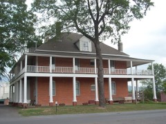 | Wright Hotel | under 500 feet | 1982 |
 | Murray County Courthouse | 0.1 miles | 1980 |
| Murray County High School Historic District | 1.3 miles | 2004 | |
| Spring Place Historic District | 2.8 miles | 2005 | |
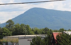 | Fort Mountain | 3.7 miles | 1977 |
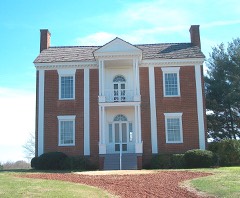 | Vann House | 4.2 miles | 1969 |
| National Archives record | The nomination case file for reference 05000693 in Record Group 79. |
| Murray County | All 9 listed properties in this county. |