 Block
From the record
One of 14 National Register listings published here for Harris County · listed in 2008 · category: Building.
Sources: the case file at the National Archives · the National Register database, National Park Service
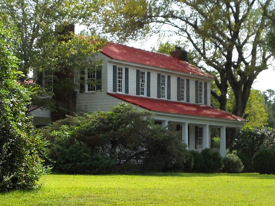
Listed on the National Register of Historic Places in 2008.
One of 14 National Register listings published here for Harris County · listed in 2008 · category: Building.
Sources: the case file at the National Archives · the National Register database, National Park Service
Regional context, not property-specific evidence. The federal wildfire occurrence database lists 239 fires within 5 miles of William and Ann Copeland Jr. House between 1992 and 2020, burning about 781 acres in total. 6 started naturally. 41 were recorded as arson. Distance is straight-line from the map coordinates, so a fire counted here may appear on a neighbouring settlement's page as well.
| Reported cause | Fires |
|---|---|
| Debris and open burning | 142 |
| Arson/incendiarism | 41 |
| Missing data/not specified/undetermined | 12 |
| Recreation and ceremony | 11 |
| Smoking | 11 |
| Equipment and vehicle use | 10 |
| Natural | 6 |
| Misuse of fire by a minor | 5 |
| Railroad operations and maintenance | 1 |
The most recent of them, most recent first, with the day each was reported and the service that recorded it.
| Date | Cause | Size | Reported by | Name on the report |
|---|---|---|---|---|
| 9 September 2012 | Debris and open burning | under an acre | Georgia Forestry Commission | FY2013-HARRIS-001 |
| 6 September 2009 | Debris and open burning | 2.5 acres | Georgia Forestry Commission | not named |
| 6 September 2002 | Missing data/not specified/undetermined | under an acre | Georgia Forestry Commission | FY2003-HARRIS-006 |
| 26 September 2019 | Debris and open burning | under an acre | Georgia Forestry Commission | FY2020HARRIS004 |
| 26 September 1996 | Debris and open burning | 1.8 acres | Georgia Forestry Commission | not named |
| 26 September 1996 | Debris and open burning | 1.2 acres | Georgia Forestry Commission | not named |
| 25 September 2005 | Debris and open burning | under an acre | Georgia Forestry Commission | not named |
| 24 September 2005 | Arson/incendiarism | under an acre | Georgia Forestry Commission | not named |
Regional context, not property-specific evidence. The National Weather Service names Shiloh, the town this property stands in, in 4 storm reports between 2008 and 2024: 2 thunderstorm wind, 1 lightning, 1 tornado. No death or injury is recorded in these reports. Each account below is quoted exactly as the forecast office filed it, from the NOAA Storm Events Database, and each date opens the federal record of that event.
| When | Event | Place named | Harm | What the report says |
|---|---|---|---|---|
| June 2008 | Lightning | Shiloh | $250,000 | The Harris County Journal reported that lightning struck a large single-story wood frame home at the corner of Second Street and First Avenue. The house was completely destroyed from the resulting fire. |
| October 2014 | Tornado (EF1) | Shiloh | $5,000 | NWS Storm Survey team found a tornado touched down just southwest of Shiloh in Harris County and traveled northeast for almost 6 miles across northwest Talbot County and southern Meriwether County. A home on the south face of Pine Mountain off Skyline Drive southwest of Manchester lost part of its roof and a large shed was destroyed. A few other homes along the path had minor damage with approximately 100 trees snapped or uprooted. EF1 damage was indicated with maximum wind speeds estimated around 100 MPH and a path width of 200 yards. [10/14/14: Tornado #1, County #1-3, EF1, Harris-Talbot-Meriwether, 2014:011]. |
| July 2024 | Thunderstorm Wind | Shiloh | $1,000 | Tree downed just north of Oak Mountain Rd . |
| June 2017 | Thunderstorm Wind | Shiloh | $1,000 | The Harris County Emergency Manager reported a tree blown down along Highway 190 in the F.D. Roosevelt State Park. |
No historic map-sheet match is published for this property yet. That does not mean no map exists. This record needs a coordinate-quality review before it can be joined to a sheet boundary. Browse the county's mapped places while that work is pending.
Other National Register properties close enough to walk or drive between, ordered by distance from this one. Both positions come from the same geocoding pass that matched these properties to their map sheets.
| Photograph | Property | Distance | Listed |
|---|---|---|---|
| Bethlehem Baptist Church Colored School | 2.7 miles | 2008 | |
| Welcome P. Duke Log House | 7.1 miles | 1999 |
| National Archives record | The nomination case file for reference 08000969 in Record Group 79. |
| Harris County | All 14 listed properties in this county. |