 Block
From the record
One of 48 National Register listings published here for Cobb County · listed in 2010 · category: District.
Sources: the case file at the National Archives · the National Register database, National Park Service
Listed on the National Register of Historic Places in 2010.
One of 48 National Register listings published here for Cobb County · listed in 2010 · category: District.
Sources: the case file at the National Archives · the National Register database, National Park Service
Regional context, not property-specific evidence. The federal wildfire occurrence database lists 227 fires within 5 miles of Lake Acworth Beach and Bathhouse between 1992 and 2019, burning about 632 acres in total. 2 started naturally. 94 were recorded as arson. Distance is straight-line from the map coordinates, so a fire counted here may appear on a neighbouring settlement's page as well.
| Reported cause | Fires |
|---|---|
| Arson/incendiarism | 94 |
| Debris and open burning | 70 |
| Misuse of fire by a minor | 24 |
| Missing data/not specified/undetermined | 10 |
| Recreation and ceremony | 9 |
| Equipment and vehicle use | 7 |
| Railroad operations and maintenance | 6 |
| Smoking | 5 |
| Natural | 2 |
The most recent of them, most recent first, with the day each was reported and the service that recorded it.
| Date | Cause | Size | Reported by | Name on the report |
|---|---|---|---|---|
| 4 September 2010 | Misuse of fire by a minor | 1.0 acres | Georgia Forestry Commission | FY2011-BARTOW-008 |
| 29 September 1993 | Debris and open burning | 1.1 acres | Georgia Forestry Commission | not named |
| 26 September 2008 | Arson/incendiarism | 2.0 acres | Georgia Forestry Commission | not named |
| 22 September 1997 | Arson/incendiarism | 1.5 acres | Georgia Forestry Commission | not named |
| 20 September 2019 | Recreation and ceremony | under an acre | Georgia Forestry Commission | FY2020PAULDING004 |
| 20 September 1998 | Missing data/not specified/undetermined | under an acre | Georgia Forestry Commission | not named |
| 20 September 1997 | Arson/incendiarism | under an acre | Georgia Forestry Commission | not named |
| 19 September 1999 | Arson/incendiarism | 2.4 acres | Georgia Forestry Commission | not named |
Regional context, not property-specific evidence. The federal mineral resources record lists 43 workings within 5 miles of Lake Acworth Beach and Bathhouse: 16 past producers, 16 occurrences, 11 prospects. None of them still produces. What was taken out: Gold, Iron, Silver, Mica. Distance is straight-line from the map coordinates, so a quarry counted here may appear on a neighbouring settlement's page as well.
| Where | Site | Commodity | Status | Recorded |
|---|---|---|---|---|
| Chalker Mine | Mica | Past Producer | ||
| Evalee Richards Prospect | Zinc, Copper, Lead | Prospect | ||
| Woodward Prospect | Graphite | Prospect | ||
| Allatoona Vein | Gold, Silver | Past Producer | Vein | |
| Avery Mine | Gold, Silver | Prospect | Vein | |
| Bartow Furnace Mine | Iron | Past Producer | ||
| Unnamed Iron Mine | Iron | Past Producer | ||
| Cox | Gold | Past Producer | Vein | |
| Eiseman | Gold | Prospect | Vein | |
| Freeman Mine | Gold | Past Producer |
Regional context, not property-specific evidence. The National Weather Service names Acworth, the town this property stands in, in 73 storm reports between 1996 and 2021: 48 hail, 19 thunderstorm wind, 3 flood, 2 flash flood. The reports record 1 death and 2 injuries. Each account below is quoted exactly as the forecast office filed it, from the NOAA Storm Events Database, and each date opens the federal record of that event.
| When | Event | Place named | Harm | What the report says |
|---|---|---|---|---|
| June 2011 | Thunderstorm Wind | Acworth | 1 killed, $30,000 | The Atlanta Journal-Contstituation and the Cobb County 911 Center reported that dozens of trees were down throughout the county. A 55-year old Marietta woman was killed instantly when a large tree fell on her vehicle while traveling along Powers Ferry Road. Many power outages were noted around the county for up to four hours in some areas. |
| July 2003 | Thunderstorm Wind | Acworth | 1 hurt, $150,000 | The Cobb county 911 center, the public, and the Marietta Daily Journal all reported that a number of trees and power lines had been blown down throughout the county, but especially between Acworth, Kennesaw, and throughout the Marietta area. A number of trees were down on roads, including Lower Roswell Road and Allgood Road. A home sustained significant damage on Jim Owens Road near the Kennesaw/Acworth border and another tree was down on a house at a residence on Allgood Road in Marietta. Two small private planes were pulled free from their tie downs at McCollum field in Marietta and flipped onto their backs. Both planes sustained significant damage as a result. A woman, who was 9-months pregnant at the time, suffered minor injuries when a tree struck the windshield of her Sport Utility Vehicle (SUV). Dobbins Air Force Base, just southeast of Marietta, recorded a wind gust of 66 miles per hour at 136 pm EDT. At least 5000 homes around the county were left without power for a number of hours. |
| June 2010 | Lightning | Acworth | 1 hurt | CBS Atlanta reported that a 14-year old boy was struck by lightning during an afternoon thunderstorm while taking shelter under a tree adjacent to Lake Acworth. The boy was taken to the hospital after being administered CPR by one of his friends. The lightning was said to have struck his lower back and then traveled through his body coming out of his ear and the top of his shoulder blades. He had to be revived three times as he was not breathing and had no pulse after the lightning strike. |
| September 2009 | Flood | Acworth | $12,600,000 | Cobb county emergency management personnel and USGS stream gages confirmed that record to catastrophic flooding continued across much of the county. Hundreds of homes, apartments, businesses, and roads sustained damages from flooding. Many culverts and/or bridges were washed out and several roads were closed. Some of the worst flooding during this event occurred in the Cobb and Douglas county area. Flood waters began to recede after 830 am EDT on the 22nd, but many locations remained in major to record flood through 715 am EDT on the 23rd. Monetary damage from flooding continued to mount, with damage during this time frame exceeding $12.5 million. |
| September 2009 | Flood | Acworth | $5,700,000 | Although flash flooding began to subside, extensive flooding was reported across the county and confirmed from several USGS stream gages. Flooding expanded on areas earlier dexperiencing flash flooding. Record flooding was observed along Sweetwater Creek near Powder Springs, Powder Springs Creek, Noses Creek, and numerous other small creeks and tributaries. At least 100 roads across the county were closed, including portions of Interstate 20 and Interstate 285 near Six Flags. Extensive rescue operations were conducted in many areas of the county as motorists found their vehicle submerged in flood waters. At least a dozen people were evacuated in Powder Springs because of rising water from Sweetwater Creek near their homes. Other neighborhoods in south Cobb county were also flooded. Damage to home and businesses throughout much of the county was tremendous. During this time period alone, it was estimated that roads and property in the county sustained damage nearing $6 million. |
| February 2008 | Thunderstorm Wind | Acworth | $5,000,000 | A storm survey conducted by the National Weather Service Forecast Office in Peachtree City, Georgia and The Weather Channel concluded that a microburst with wind speeds up to 90 mph impacted the northeast part of Cobb county, causing extensive damage to trees, homes, and power lines. Several roads were also blocked. The majority of the damage was concentrated within a 0.3 to 1.0 mile wide path that extended from the Canterbury Woods Country Club north of Marietta eastward to the Fulton county line east of Sandy Plains. The damage continued into north Fulton county near Roswell. Extensive damage to trees and homes was observed in the neighborhoods around the Shallowford Road area. Several homes sustained moderate to major damage when large 80 foot pine trees fell on and through the structures. Thunderstorm winds caused damage to trees, power lines and other minor structural damage in many other parts of the county as well. A total of 87 structures suffered damage, mostly residential single-family homes. Two structures were destroyed, 20 suffered major damage, and 49 sustained minor damage. Many areas of the county were left without power for several hours. At least 75 locations observed downed trees. Trees were down in the cities of Acworth, Kennesaw, and Marietta. The ASOS at Dobbins Air Force Base in Marietta recorded a wind gust of 64 mph at 627 am EDT. |
| April 2006 | Hail | Acworth | $5,000,000 | Numerous reports of hail ranging in size from pennies to golf balls were reported across Cobb county from the northwest corner near Acworth to Smyrna in the southeast part. The storm was strongest when it entered the northwest part of the county, then gradually weakened as it moved southeast across the county. Nickel to golf ball-size hail was reported in the Kennesaw area, while only penny-sized hail was reported in the Smyrna area. Car windshields were cracked in the Kennesaw area where golf ball-size hail fell. |
| February 2005 | Hail | Acworth | $5,000,000 | Numerous reports of large hail were received from the public in Acworth, Kennesaw, and Marietta. Golf ball to tennis ball-sized hail was reported in Acworth, golf ball-sized hail in Kennesaw, and nickel to quarter-sized hail in Marietta. Damage was reported to vehicles and residences. |
| March 2011 | Hail | Acworth | $3,810,000 | The public observed golf ball-sized hail west of Kennesaw and near Due West, with quarter-sized hail southwest of Acworth and near Marietta. WSR-88D suggests that at least quarter-sized hail continued southeast across the county toward Smyrna and Vinings. Wind gusts of 45 mph were also noted at two separate locations in the county during this storm. |
| March 2012 | Hail | Acworth | $3,758,000 | The public reported golf ball sized hail in Acworth, south of Interstate 75 toward Sugar Maple Lane. |
| June 2010 | Hail | Acworth | $2,600,000 | The public measured golf ball-sized hail in the Acworth area. |
| April 2009 | Hail | Acworth | $1,500,000 | Many reports of quarter sized-hail were received across northern Cobb county from Acworth to Kennesaw to Marietta and the northeast corner of the county. The public reported golf ball-sized hail northeast of Acworth near the Cherokee county line. The public estimated that wind gusts with the thunderstorm were near 50 mph, but no structural, tree, or power line damage was reported. |
| April 2007 | Hail | Acworth | $1,000,000 | Numerous reports of hail, ranging in size from quarters to half-dollars, were received from the public across Cobb county. The hail storm began in the west part of the county about six miles southwest of Acworth and tracked east-southeast across the county affecting Lost Mountain, Marietta, and Smyrna. Quarter-sized hail was reported at most locations, but half-dollar-sized hail was reported from west central Cobb county, about six miles southwest of Kennesaw near Lost Mountain. |
| September 2009 | Flash Flood | Acworth | $230,000 | Significant flash flooding continued and expanded from southern into western Cobb county during this time frame. USGS stream gages showed that a number of creeks and streams across western and southern Cobb county were already in flood or rose to and exceeded flood stage during this time frame. This included Powder Springs Creek, Noses Creek, and Sweetwater Creek. Heavy rain and thunderstorms continued to track repeatedly from southwest to northeast across the same areas moving the area closer and closer to the record and historical flooding that unfolded during the early morning hours of the 21st. During this time period, an increasing number of roads and culverts were damaged from the rising flood waters. Damage during this time period across western Cobb county was estimated to exceed $200,000. |
| July 2000 | Thunderstorm Wind | Acworth | $50,000 | The Canton Cherokee Tribune and the public reported numerous trees down across mainly the western half of Cobb county from Acworth, to Kennesaw, to Powder Springs, and westward to the Paulding county line. Most of the damage was sustained in the Apache Woods subdivision of Acworth where a 1 foot diameter tree fell through a roof causing significant damage to the structure. Numerous other trees were reported down in this subdivision as well. Another subdivision hard hit was the English Oaks subdivision of Kennesaw where numerous trees were downed by the thunderstorm winds. |
| February 2008 | Thunderstorm Wind | Acworth | $25,000 | The Cobb County Emergency Manager and the public reported that many trees and a number of power lines were blown down across the county from Acworth, to Marietta, to Smyrna. Several fences were blown over and shingles were blown off some homes. |
| April 2011 | Flash Flood | Acworth | $20,000 | The USGS Stream Gage on Sope Creek at Marietta (MARG1) reached its flood stage of 12.0 feet at 11:18 pm on April 15, 2011. The creek remained above flood stage until 3:41 am EDT on April 16, 2011. A vehicle was stranded in flood waters in the eastern part of the county and the basement of a home was flooded on Norman Road in Kennesaw. Otherwise, damage was confined to minor debris removal adjacent to the flooded creek. |
| July 1998 | Thunderstorm Wind | Acworth | $20,000 | Several public reports indicated dime to nickel size hail fell. At least a couple of homes sustained roof and chimney damage from falling trees. |
| May 2017 | Thunderstorm Wind | Acworth | $10,000 | The Cobb County 911 center reported numerous trees and power lines blown down across the northern half of the county from Acworth across Kennesaw to East Cobb. Locations include Logan Road at Cherokee Street, Lilac Court and East Springs Meadow Drive, Beaumont Drive Northwest and Stilesboro Road, Battle Drive and Cobb International Boulevard, Johnson Ferry Road at Hampton Farms Drive, and Old Orchard Trail at Woodland Path. |
| August 2008 | Thunderstorm Wind | Acworth | $10,000 | The public reported that dozens of trees were blown down from Acworth, to Kennesaw, especially in the Red Top Mountain Estates located southwest of Acworth in the far northwest part of the county. Doppler base velocity wind data indicated inbound values in excess of 60 mph across much of the eastern two-thirds of the county. |
| July 2017 | Thunderstorm Wind | Acworth | $8,000 | The Cobb County 911 center reported trees and power lines blown down around the Acworth area. Locations include Old McEver Road and Legacy Park. |
| June 2010 | Thunderstorm Wind | Acworth | $7,000 | An amateur radio operator reported that several trees were down across the western part of the county. |
| July 2015 | Thunderstorm Wind | Acworth | $5,000 | The Cobb County 911 Center reported several trees blown down. |
| April 2011 | Thunderstorm Wind | Acworth | $5,000 | The Cobb County 911 Center reported that several trees and power lines were down in the northwest part of the county near Kennesaw. |
| June 2011 | Thunderstorm Wind | Acworth | $5,000 | The Cobb County Emergency Management Director reported that at least a dozen trees were down across the county, but especially in the Mableton area. |
| October 2009 | Flood | Acworth | $5,000 | The USGS stream gage on Noses Creek near Powder Springs reached its flood stage of 11.0 feet at 742 pm EDT and remained in flood until 1130 pm EDT. Damage was confined to minor debris removal adjacent to the creek. |
| May 1998 | Hail | Acworth | $5,000 | Several public reports from across northern Cobb county indicated hail ranging from dime size to as big as a fist. Damage to a house was reported. |
| April 1997 | Hail | Acworth | $5,000 | no account filed |
| May 2010 | Thunderstorm Wind | Acworth | $3,000 | The public reported that more than half-a-dozen trees were down in the far northwestern part of the county, southwest of Acworth and northwest of Due West. Several trees were down in the vicinity of Daphne Lane. |
| November 2002 | Thunderstorm Wind | Acworth | $2,000 | The Cobb county 911 center reported that some trees and power lines were blown down. |
| May 1998 | Hail | Acworth | $2,000 | The public reported golf ball size hail near Kennesaw and dime to quarter size around Acworth and Marietta. A funnel cloud was reportedly spotted in the Kennesaw area. |
| July 2008 | Thunderstorm Wind | Acworth | $1,500 | The Acworth Police reported that six large trees were down in the northeast part of the city. |
| September 2011 | Thunderstorm Wind | Acworth | $1,000 | The Cobb County 911 Center reported that three to four trees were down in the far northwest part of the county near Acworth. WSR-88D storm-relative velocity data indicated strong rotation in the area at this time and a tornado warning was in effect for this part of Cobb county. However, no tornado damage was confirmed from this signature. |
| July 2006 | Thunderstorm Wind | Acworth | $500 | The public reported that one large tree was blown down by a thunderstorm wind gust just north of the railroad tracks in downtown Acworth. In the same general area, it was noted that there were a number of tree limbs and leaf debris scattered about. |
| July 1999 | Thunderstorm Wind | Acworth | $500 | The public reported trees blown down. |
| March 1996 | Hail | Acworth | $500 | no account filed |
| March 2021 | Hail | Acworth | - | The public reported quarter-size hail on McEver Park Circle. |
| June 2018 | Hail | Acworth | - | A report of quarter size hail in Acworth was received over social media. |
| April 2016 | Hail | Acworth | - | A trained spotter reported penny size hail at I-75 and Highway 92. |
| June 2011 | Hail | Acworth | - | The Cobb County Emergency Management Director reported penny-sized hail near Acworth. |
| February 2011 | Hail | Acworth | - | A trained storm spotter observed quarter-sized hail in far north and northeastern Cobb county, near the intersection of Interstate-575 and Bells Ferry Road. |
| June 2011 | Hail | Acworth | - | Several reports of quarter to half-dollar-sized hail were received from the public across western and central Cobb county from southwest of Acworth, along the Paulding county line, to south of Kennesaw, and to just northwest of Marietta. |
| June 2011 | Hail | Acworth | - | The public observed quarter-sized hail in the northwest part of the county near Kennesaw. |
| May 2010 | Hail | Acworth | - | A storm spotter observed quarter-sized hail in the far northwestern part of Cobb county southwest of Acworth and just northwest of Due West. |
| April 2009 | Hail | Acworth | - | The public observed penny-sized hail in the extreme northern portion of Cobb county, near the Cherokee county line, northeast of Acworth. |
| May 2008 | Hail | Acworth | - | The public observed quarter-sized hail in both Acworth and Marietta. |
| July 2008 | Hail | Acworth | - | The public observed penny-sized hail in the Acworth area. The hail fell for up to three minutes in the area. |
| August 2008 | Hail | Acworth | - | An amateur radio operator reported penny-sized hail in the Kennesaw area. The public observed penny-sized hail on the east side of Kennesaw at exit three on I-575, and a storm spotter observed hail in the far northeastern part of the county at the intersection of Johnson Ferry and Roswell Roads. |
| July 2007 | Hail | Acworth | - | The public observed up to 10 minutes of quarter-sized hail in the Acworth area. Smaller hail, mostly on the order of pea-sized hail, was observed further east toward Sandy Springs. |
| May 2007 | Hail | Acworth | - | A storm spotter observed penny-sized hail. |
| April 2006 | Hail | Acworth | - | The public reported quarter-sized hail. |
| May 2006 | Hail | Acworth | - | The public reported quarter-sized hail in the Acworth area. |
| June 2005 | Hail | Acworth | - | A meteorologist with The Weather Channel reported penny-sized hail at their headquarters. |
| June 2005 | Hail | Acworth | - | Several reports of penny to quarter-sized hail were received from the public. |
| December 2005 | Hail | Acworth | - | The public reported quarter-sized hail. |
| December 2004 | Hail | Acworth | - | Several reports were received from the public of penny-sized hail in the Acworth and Kennesaw areas. Nickel-sized hail was reported by the public in Marietta. |
| August 2003 | Hail | Acworth | - | The public reported penny to quarter-sized hail. |
| July 2002 | Hail | Acworth | - | The public reported quarter size hail. |
| July 2002 | Hail | Acworth | - | The public reported dime size hail. |
| July 2002 | Hail | Acworth | - | An amateur radio operator reported dime to nickel size hail near Johnson's Ferry Road in Marietta, while the public reported dime to nickel size hail in and just east of Marietta. The public also reported dime size hail in Acworth. |
No historic map-sheet match is published for this property yet. That does not mean no map exists. This record needs a coordinate-quality review before it can be joined to a sheet boundary. Browse the county's mapped places while that work is pending.
Other National Register properties close enough to walk or drive between, ordered by distance from this one. Both positions come from the same geocoding pass that matched these properties to their map sheets.
| Photograph | Property | Distance | Listed |
|---|---|---|---|
 | Acworth Downtown Historic District | 0.4 miles | 2006 |
| Collins Avenue Historic District | 0.4 miles | 2001 | |
 | Bethel AME Church | 0.6 miles | 2002 |
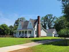 | Tarleton Moore House | 0.6 miles | 2006 |
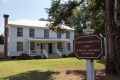 | Stephen D. Cowen House | 1.8 miles | 2002 |
| North Main Street Historic District | 4.3 miles | 1980 |
| National Archives record | The nomination case file for reference 09001202 in Record Group 79. |
| Cobb County | All 48 listed properties in this county. |