 Block
From the record
One of 7 National Register listings published here for Upson County · listed in 2021 · category: District.
Sources: the National Register database, National Park Service
Listed on the National Register of Historic Places in 2021.
One of 7 National Register listings published here for Upson County · listed in 2021 · category: District.
Sources: the National Register database, National Park Service
Regional context, not property-specific evidence. The federal wildfire occurrence database lists 524 fires within 5 miles of Silvertown Historic District between 1992 and 2020, burning about 1,429 acres in total. 13 started naturally. 56 were recorded as arson. Distance is straight-line from the map coordinates, so a fire counted here may appear on a neighbouring settlement's page as well.
| Reported cause | Fires |
|---|---|
| Debris and open burning | 327 |
| Arson/incendiarism | 56 |
| Missing data/not specified/undetermined | 38 |
| Misuse of fire by a minor | 36 |
| Equipment and vehicle use | 32 |
| Recreation and ceremony | 16 |
| Natural | 13 |
| Smoking | 4 |
| Railroad operations and maintenance | 2 |
The most recent of them, most recent first, with the day each was reported and the service that recorded it.
| Date | Cause | Size | Reported by | Name on the report |
|---|---|---|---|---|
| 9 September 2005 | Equipment and vehicle use | under an acre | Georgia Forestry Commission | not named |
| 9 September 1999 | Debris and open burning | under an acre | Georgia Forestry Commission | not named |
| 8 September 2016 | Debris and open burning | under an acre | Georgia Forestry Commission | FY2017-UPSON-003 |
| 5 September 1997 | Missing data/not specified/undetermined | 4.7 acres | Georgia Forestry Commission | not named |
| 4 September 2002 | Recreation and ceremony | under an acre | Georgia Forestry Commission | FY2003-UPSON-011 |
| 4 September 1995 | Arson/incendiarism | 1.4 acres | Georgia Forestry Commission | not named |
| 3 September 2010 | Missing data/not specified/undetermined | under an acre | Georgia Forestry Commission | FY2011-UPSON-007 |
| 29 September 2019 | Arson/incendiarism | under an acre | Georgia Forestry Commission | FY2020UPSON013 |
Regional context, not property-specific evidence. The federal mineral resources record lists 18 workings within 5 miles of Silvertown Historic District: 14 prospects, 4 past producers. None of them still produces. What was taken out: Mica. Distance is straight-line from the map coordinates, so a quarry counted here may appear on a neighbouring settlement's page as well.
| Where | Site | Commodity | Status | Recorded |
|---|---|---|---|---|
| B S Gibson Prospects | Mica | Prospect | ||
| Bentley Prospect | Mica | Prospect | ||
| Corley Mine | Mica | Past Producer | ||
| Corley Prospects | Mica | Prospect | ||
| Cumbie Prospects | Mica | Prospect | ||
| Emmit Trice Prospect | Mica | Prospect | ||
| F M Thompson Property | Mica | Prospect | ||
| F.E.Thompson Prospect | Mica | Prospect | ||
| Grace Prospect | Mica | Prospect | ||
| J J Reeves Prospect | Mica | Prospect |
Regional context, not property-specific evidence. The National Weather Service names Thomaston, the town this property stands in, in 82 storm reports between 1994 and 2014: 37 hail, 24 thunderstorm wind, 12 lightning, 3 flood. The reports record 3 injuries. Each account below is quoted exactly as the forecast office filed it, from the NOAA Storm Events Database, and each date opens the federal record of that event.
| When | Event | Place named | Harm | What the report says |
|---|---|---|---|---|
| May 1997 | Thunderstorm Wind | Thomaston | 2 hurt, $15,000 | One whole tree and several large limbs fell on power lines. A metal shelter attached to a nursing home was ripped off the building. Two nursing home employees were knocked down by the wind gust as it blew through the door. |
| March 2001 | Lightning | Thomaston | 1 hurt | The Upson County Sheriff's Department reported that a Sheriff's Deputy was struck by lightning while on duty at the scene of an accident on the Barnesville Highway, approximately 2 miles northeast of Thomaston. He was still conscious and alert, but reported tingling sensations in his extremities. He was transported to a local hospital. |
| March 2005 | Lightning | Thomaston | $250,000 | The Upson County Emergency Manager reported that two homes were struck by lightning. The roof of one home was set on fire and the home was completely destroyed. The other home suffered major damage. |
| May 2003 | Thunderstorm Wind | Thomaston | $250,000 | The Upson county 911 center, and the Thomaston newspaper reported that numerous trees were blown down causing major damage in the city. Several of the trees landed on homes and even some vehicles causing minor to moderate structural damage. Others brought down power lines, telephone lines, and cable TV lines. |
| June 2008 | Thunderstorm Wind | Thomaston | $200,000 | The Upson County 911 Center reported that a thunderstorm downburst resulted in one to two dozen trees being blown down in the Sunset Village area just north of Georgia Highway 74 along and west of Sunnyside Road. One home sustained considerable damage when several trees fell on the structure. A pool house was blown over on Lucille Drive and a flag pole was also bent over. |
| March 1996 | Tornado (F1) | Thomaston | $200,000 | no account filed |
| July 2008 | Lightning | Thomaston | $150,000 | The Upson County Emergency Management Director reported that lightning struck and set a house on fire just north of Thomaston. |
| June 1998 | Thunderstorm Wind | Thomaston | $150,000 | Thunderstorm winds knocked trees down on houses between Thomaston and Crest. Six chicken houses and farm buildings were destroyed or damaged and several house roofs were damaged in the Yatesville area. The city of Yatesville lost power. |
| April 2003 | Lightning | Thomaston | $100,000 | The Thomaston Times reported that a chicken house was struck and completely destroyed by lightning, including 15,000 two-and-a-half-year-old chickens. The local power company determined that the lightning struck a power transformer behind the building and started a fire at every electrical outlet in the structure. |
| August 2008 | Lightning | Thomaston | $50,000 | The Upson County Emergency Management Director reported a structural fire as a result of a lightning strike. Specific damages were not provided. |
| May 2008 | Thunderstorm Wind | Thomaston | $25,000 | The AWOS, located four miles northeast of Thomaston, at the Thomaston-Upson County Airport recorded a wind gusts of 61 mph. The Upson County 911 Center reported that several trees and power lines were blown down from the north side of Thomaston to Yatesville as thunderstorms with these wind gusts swept through the north ern and eastern part of the county. |
| July 2006 | Thunderstorm Wind | Thomaston | $25,000 | The Upson County Emergency Management Director reported that a couple of trees were down on homes at two different locations, one in downtown Thomaston and another just southeast of Thomaston. |
| October 2002 | Lightning | Thomaston | $25,000 | The Thomaston Times reported that lightning struck an 85-year old home. The fire smoldered for about half-a-day, then ignited into flames. The house suffered moderate damage, but most of the contents were saved. |
| January 2000 | Thunderstorm Wind | Thomaston | $20,000 | Upson county 911 reported a large tree down on a house on the north side of Thomaston. A newspaper clipping showed the house was knocked off its foundation and sustained roof damage. Several other trees were knocked down in Thomaston and across the county. |
| August 2003 | Flash Flood | Thomaston | $15,000 | The Upson county 911 center reported that persistent thunderstorms with heavy rain had resulted in considerable flooding in the Thomaston area. Eleven roads had to be closed because of flooding, and one remained closed for a few hours even after the rain had ended. Flood waters rose into several homes. Three homes had to be evacuated because of flooding in a low-lying area of the city. In addition, water was flowing over the dam of a small pond northwest of Thomaston, forcing the closure of the road below the dam. |
| July 2002 | Thunderstorm Wind | Thomaston | $5,000 | The public reported that a tree fell down on a mobile home. |
| June 1994 | Thunderstorm Wind | Thomaston | $5,000 | Several large trees were downed by thunderstorm winds. |
| July 2007 | Thunderstorm Wind | Thomaston | $3,000 | The Upson County Emergency Management Director reported that about 10 trees were down in the Thomaston area, mainly in the vicnity of Georgia Highway 74 and State Park Road. One tree was also down in the northern city limits of Thomaston. Pea-sized hail was observed by an amateur radio operator just within the southern city limits of Thomaston. |
| July 1997 | Thunderstorm Wind | Thomaston | $3,000 | Numerous trees and power lines were knocked down by thunderstorm winds. |
| August 2014 | Thunderstorm Wind | Thomaston | $2,000 | The Upson County 911 Center reported 6 trees down, some on power lines, in the vicinity of Thomaston. |
| July 2007 | Lightning | Thomaston | $2,000 | The Upson County 911 Center reported that lightning struck a tree and a transformer in the city. The transformer was blown and the tree fell down onto the roadway. |
| August 2002 | Thunderstorm Wind | Thomaston | $2,000 | The Upson county Emergency Management Office reported that several large oak trees were uprooted by thunderstorm winds in Thomaston. In addition, there were other reports of downed limbs in the area. |
| October 2002 | Lightning | Thomaston | $2,000 | The Upson county Emergency Management Director reported that lightning struck and killed a horse. |
| April 1997 | Thunderstorm Wind | Thomaston | $2,000 | no account filed |
| July 2008 | Thunderstorm Wind | Thomaston | $1,000 | The Upson County Emergency Management Director reported that a couple of power lines were down on the west side of Thomaston. |
| May 2007 | Lightning | Thomaston | $1,000 | The Upson County Emergency Management Director reported that lightning struck a home near Sunset Village or between Old Alabama Road and Jeff Davis Road. Only minor electrical damage was noted. |
| July 2005 | Lightning | Thomaston | $1,000 | The Upson County Emergency Management Director reported that lightning struck near a senior citizens center and caused $1,000 in damages to a deep freezer at the facility. |
| April 2002 | Thunderstorm Wind | Thomaston | $1,000 | The Upson county Emergency Management Director reported that several trees had been blown down. |
| July 2002 | Thunderstorm Wind | Thomaston | $1,000 | The Upson county Emergency Management Director reported that trees were blown down. |
| June 1999 | Thunderstorm Wind | Thomaston | $1,000 | Upson county 911 reported trees blown down by thunderstom winds. |
| July 2007 | Lightning | Thomaston | $500 | The Upson County Emergency Management Director reported that lightning struck a home in town on Thurston Avenue. Minor damage was reported to the clothes dryer, where the lightning strike occurred. |
| July 2002 | Thunderstorm Wind | East Thomaston | $500 | An amateur radio operator reported that one inch tree limbs were down in East Thomaston near the intersection of Georgia Highway 36 and Georgia Highway 74. Trees were reported down in Thomaston by the public. |
| June 2001 | Thunderstorm Wind | Thomaston | $500 | A storm spotter reported that a few trees were blown down. |
| July 1995 | Thunderstorm Wind | Thomaston | $500 | Thunderstorm winds knocked trees down south of Thomaston. |
| May 2004 | Thunderstorm Wind | Thomaston | $250 | The Upson county 911 center reported that one tree was blown down on a road. |
| April 2011 | Hail | Thomaston | - | The public observed penny-sized hail near Thomaston. |
| April 2011 | Hail | Thomaston | - | An amateur radio operator relayed a report of penny-sized hail in the far western portion of Upson county, just north of Sprewell Bluff State Park. WSR-88D radar data suggests that hail of similar size likely fell across much of the county from this point east-northeast to the Lamar county line northeast of The Rock. |
| March 2011 | Hail | Thomaston | - | Amateur radio operators relayed reports of quarter-sized hail from Thomaston to just east of Thomaston. |
| February 2010 | Hail | Thomaston | - | The public reported penny-sized hail in the Thomaston area. |
| March 2010 | Hail | Thomaston | - | The Upson County Emergency Management Director reported that dime to nickel-sized hail covered the ground at many locations across the county from southwest of Thomaston to The Rock. The most significant reports of hail were received from the northeast part of the county between Thomaston and The Rock. |
| May 2009 | Hail | Thomaston | - | The public observed penny-sized hail in Thomaston and on the south side of Thomaston at the Raintree Golf Course. |
| February 2008 | Hail | Thomaston | - | The Upson County Emergency Management Director observed nickel-sized hail four miles east of Thomaston, while the public reported penny-sized hail in downtown Thomaston and pea-sized hail five miles southwest of Thomaston. |
| May 2008 | Hail | Thomaston | - | The Upson County Emergency Management Director reported nickel-sized hail at the Thomaston-Upson county airport northeast of Thomaston. Radar supported that hail of penny to nickel-size likely fell from here east-southeastward toward Yatesville. |
| July 2008 | Heavy Rain | Thomaston | - | The Upson County Emergency Management Director reported that street flooding was observed around Thomaston. Two roads were flooded and closed as a result. Doppler radar rainfall estimates showed that three to four inches of rain fell on the west and northwest side of Thomaston between Thomaston and Pickard. |
| August 2008 | Funnel Cloud | Thomaston | - | The public observed a funnel cloud just north-northeast of Thomaston. This funnel cloud was being observed from the same thunderstorm cell that spawned funnel clouds in southwest Upson county 20 minutes earlier. |
| July 2007 | Hail | Thomaston | - | The public observed penny-sized hail. |
| June 2007 | Hail | Thomaston | - | The Upson County Emergency Management Director observed quarter-sized hail in Thomaston. A storm spotter reported nickel-sized hail on the east side of Thomaston. The same spotter also estimated that wind gusts in the area were between 50 and 60 mph. |
| July 2006 | Hail | Thomaston | - | Reports of hail, ranging in size from pennies to quarters, were received from the public in the Thomaston area. The Upson County Emergency Management Director reported nickel-sized hail from just southeast to 2 miles north of Thomaston. |
| March 2005 | Hail | Thomaston | - | The Upson County 911 Center reported penny-sized hail. |
| March 2005 | Hail | Thomaston | - | The public reported nickel-sized hail. |
| April 2005 | Hail | Thomaston | - | The Upson County Emergency Management Director reported nickel-sized hail south of Thomaston, while the public reported penny-sized hail in Thomaston. |
| December 2005 | Hail | Thomaston | - | The Upson County 911 Center reported quarter-sized hail while the public reported penny-sized hail. |
| December 2005 | Hail | Thomaston | - | The public reported quarter-sized hail. |
| March 2004 | Hail | Thomaston | - | The public reported penny-sized hail. |
| August 2003 | Hail | Thomaston | - | The Upson county 911 center reported penny-sized hail. |
| April 2002 | Hail | Thomaston | - | The Upson county Emergency Management Director reported dime size hail. |
| June 2002 | Lightning | Thomaston | - | Two structural fires caused by lightning. Damage was unknown and there were no injuries reported. |
| June 2002 | Hail | Thomaston | - | An amateur radio operator reported dime size hail. |
| May 2002 | Flood | Thomaston | - | The public reported street flooding. One reported indicated that 0.90 inch of rain fell in 20 minutes. |
| July 2002 | Thunderstorm Wind | Thomaston | - | An amateur radio operator estimated winds of 60 to 65 mph. |
No historic map-sheet match is published for this property yet. That does not mean no map exists. This record needs a coordinate-quality review before it can be joined to a sheet boundary. Browse the county's mapped places while that work is pending.
Other National Register properties close enough to walk or drive between, ordered by distance from this one. Both positions come from the same geocoding pass that matched these properties to their map sheets.
| Photograph | Property | Distance | Listed |
|---|---|---|---|
| John and Effie McDaniel House | 1.2 miles | 2021 | |
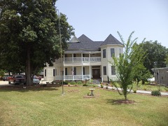 | W. A. Harp House | 1.3 miles | 1990 |
 | Upson County County Courthouse | 1.3 miles | 1980 |
 | Sydney Barron House | 1.7 miles | 1994 |
| Rose Hill Mill and House | 2.4 miles | 1980 |
| National Archives record | The nomination case file for reference 100006336 in Record Group 79. |
| Upson County | All 7 listed properties in this county. |