 Block
From the record
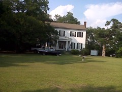
One of 9 National Register listings published here for Burke County · listed in 2021 · category: Building.
Sources: the National Register database, National Park Service
Listed on the National Register of Historic Places in 2021.
One of 9 National Register listings published here for Burke County · listed in 2021 · category: Building.
Sources: the National Register database, National Park Service
Regional context, not property-specific evidence. The federal wildfire occurrence database lists 231 fires within 5 miles of Girard Elementary School between 1992 and 2020, burning about 3,813 acres in total. 8 started naturally. 66 were recorded as arson. Distance is straight-line from the map coordinates, so a fire counted here may appear on a neighbouring settlement's page as well.
| Reported cause | Fires |
|---|---|
| Debris and open burning | 128 |
| Arson/incendiarism | 66 |
| Missing data/not specified/undetermined | 12 |
| Natural | 8 |
| Smoking | 6 |
| Equipment and vehicle use | 5 |
| Misuse of fire by a minor | 5 |
| Recreation and ceremony | 1 |
The most recent of them, most recent first, with the day each was reported and the service that recorded it.
| Date | Cause | Size | Reported by | Name on the report |
|---|---|---|---|---|
| 29 September 2017 | Arson/incendiarism | 4.7 acres | Georgia Forestry Commission | FY2018-BURKE-007 |
| 29 September 2013 | Debris and open burning | 13 acres | Georgia Forestry Commission | FY2014-BURKE-004 |
| 29 September 1993 | Debris and open burning | 6.5 acres | Georgia Forestry Commission | not named |
| 2 September 2009 | Equipment and vehicle use | 7.2 acres | Georgia Forestry Commission | not named |
| 15 September 1992 | Debris and open burning | under an acre | Georgia Forestry Commission | not named |
| 14 September 1996 | Debris and open burning | 2.3 acres | Georgia Forestry Commission | not named |
| 13 September 1993 | Debris and open burning | under an acre | Georgia Forestry Commission | not named |
| 9 August 2001 | Debris and open burning | 4.0 acres | Georgia Forestry Commission | FY2002-BURKE-006 |
Regional context, not property-specific evidence. The National Weather Service names Girard, the town this property stands in, in 23 storm reports between 1995 and 2025: 17 thunderstorm wind, 4 hail, 2 tornado. The reports record 1 injury. Each account below is quoted exactly as the forecast office filed it, from the NOAA Storm Events Database, and each date opens the federal record of that event.
| When | Event | Place named | Harm | What the report says |
|---|---|---|---|---|
| July 2000 | Thunderstorm Wind | Girard | 1 hurt | EM reported roof torn off trailer, trees down, and a shed blown onto a vehicle slightly injuring one person on River rd. |
| March 2013 | Thunderstorm Wind | Girard | $6,000 | DOT reported several trees down around the Gerard area. |
| July 1995 | Thunderstorm Wind | Girard | $1,000 | Thunderstorm winds knocked down trees, some of which fell on power lines, causing power outages. |
| March 2025 | Tornado (EF0) | Girard | - | A National Weather Service storm survey determined that one of two close proximity EF-0 tornadoes touched down east of Girard, GA with peak wind speeds of 80 mph. The northernmost tornado began near the intersection of Stoney Bluff Road and Thankful Church Road where it snapped several pine trees. The tornado then continued northeast into an inaccessible heavily wooded area, before snapping additional pine trees along River Road. Given a lack of access, this tornado is assumed to have dissipated just prior to reaching the Savannah River. |
| March 2025 | Tornado (EF0) | Girard | - | National Weather Service storm survey determined one of two close proximity tornadoes touched down east Girard. The southern most of these two tornadoes began along Royal Road just north of Stoney Bluff Road causing minor tree damage. Moving northeast, the tornado caused shingle damage to a residence followed by additional tree damage along Royal Road. Given a lack of access, this tornado is assumed to have dissipated just prior to reaching the Savannah River. |
| January 2024 | Thunderstorm Wind | Girard | - | Several trees were downed on Creek Rd partially blocking the road. |
| June 2024 | Thunderstorm Wind | Girard | - | Plant Vogtle employees reported several trees fell on the power plant property near the Savannah River. |
| June 2022 | Thunderstorm Wind | Girard | - | Burke Co dispatch reported a tree down in Girard. Time estimated. |
| June 2022 | Thunderstorm Wind | Girard | - | Numerous trees were downed in Girard. Time estimated. |
| June 2019 | Thunderstorm Wind | Girard | - | Tree down on Millhouse Rd between Sardis and Girard. Time estimated. |
| May 2016 | Hail | Girard | - | Reported dime to penny size hail on Griffin Landing Road. |
| July 2016 | Thunderstorm Wind | Girard | - | Reported trees and power lines down at Claxton Road, Buck Lane and Creek Road in the Girard area. |
| July 2012 | Thunderstorm Wind | Girard | - | Sheriff Dispatch reported trees down along River Road. |
| July 2012 | Thunderstorm Wind | Girard | - | Sheriff Dispatch reported trees down on Vine Road near Girard. |
| May 2008 | Hail | Girard | - | Fire department reported golf ball size hail. |
| May 2008 | Hail | Girard | - | Fire department reported nickel size hail. |
| August 2007 | Thunderstorm Wind | Girard | - | DOT reported several trees down in the Girard to Sardis area on secondary roads. |
| May 2006 | Thunderstorm Wind | Girard | - | Girard Fire Dept. reported trees down on Millhaven and Stoney Bluff roads. |
| July 2006 | Thunderstorm Wind | Girard | - | Highway Dept. reported a couple of trees down on Claxton road near Girard. |
| December 2005 | Hail | Girard | - | Public reported nickel size hail. |
| June 2003 | Thunderstorm Wind | Girard | - | Highway dept. and Post Office reported trees down in Girard out to 8 miles east of Girard to the county line. |
| August 2002 | Thunderstorm Wind | Girard | - | Highway Dept reported some trees down on Vine road near Girard. |
| August 2001 | Thunderstorm Wind | Girard | - | Post Office reported trees down on Sweetwater road. |
No historic map-sheet match is published for this property yet. That does not mean no map exists. This record needs a coordinate-quality review before it can be joined to a sheet boundary. Browse the county's mapped places while that work is pending.
Other National Register properties close enough to walk or drive between, ordered by distance from this one. Both positions come from the same geocoding pass that matched these properties to their map sheets.
| Photograph | Property | Distance | Listed |
|---|---|---|---|
 | McCanaan Missionary Baptist Church and Cemetery | 5.1 miles | 2001 |
 | Sapp Plantation | 6.1 miles | 1980 |
| National Archives record | The nomination case file for reference 100006735 in Record Group 79. |
| Burke County | All 9 listed properties in this county. |