 Block
From the record
One of 17 National Register listings published here for Carroll County · listed in 2025 · category: District.
Sources: the National Register database, National Park Service
Listed on the National Register of Historic Places in 2025.
One of 17 National Register listings published here for Carroll County · listed in 2025 · category: District.
Sources: the National Register database, National Park Service
Regional context, not property-specific evidence. The federal wildfire occurrence database lists 180 fires within 5 miles of Banning Mills Industrial Archeological District between 1992 and 2020, burning about 678 acres in total. 5 started naturally. 55 were recorded as arson. Distance is straight-line from the map coordinates, so a fire counted here may appear on a neighbouring settlement's page as well.
| Reported cause | Fires |
|---|---|
| Debris and open burning | 88 |
| Arson/incendiarism | 55 |
| Equipment and vehicle use | 10 |
| Missing data/not specified/undetermined | 9 |
| Recreation and ceremony | 9 |
| Natural | 5 |
| Misuse of fire by a minor | 2 |
| Smoking | 2 |
The most recent of them, most recent first, with the day each was reported and the service that recorded it.
| Date | Cause | Size | Reported by | Name on the report |
|---|---|---|---|---|
| 8 September 1993 | Arson/incendiarism | 1.0 acres | Georgia Forestry Commission | not named |
| 6 September 2005 | Arson/incendiarism | 1.1 acres | Georgia Forestry Commission | not named |
| 5 September 1997 | Debris and open burning | 1.0 acres | Georgia Forestry Commission | not named |
| 30 September 2003 | Debris and open burning | under an acre | Georgia Forestry Commission | not named |
| 25 September 2008 | Arson/incendiarism | 1.5 acres | Georgia Forestry Commission | not named |
| 24 September 1993 | Arson/incendiarism | under an acre | Georgia Forestry Commission | not named |
| 21 September 2010 | Recreation and ceremony | under an acre | Georgia Forestry Commission | FY2011-CARROLL-009 |
| 18 September 1999 | Arson/incendiarism | 5.2 acres | Georgia Forestry Commission | not named |
Regional context, not property-specific evidence. The federal mineral resources record lists 1 working within 5 miles of Banning Mills Industrial Archeological District: 1 producer. All of them still produce. What was taken out: Sand and Gravel, Construction. Distance is straight-line from the map coordinates, so a quarry counted here may appear on a neighbouring settlement's page as well.
| Where | Site | Commodity | Status | Recorded |
|---|---|---|---|---|
| Jones Mill Pit | Sand and Gravel, Construction | Producer |
Regional context, not property-specific evidence. The National Weather Service names Whitesburg, the town this property stands in, in 19 storm reports between 1997 and 2025: 12 thunderstorm wind, 6 hail, 1 lightning. No death or injury is recorded in these reports. Each account below is quoted exactly as the forecast office filed it, from the NOAA Storm Events Database, and each date opens the federal record of that event.
| When | Event | Place named | Harm | What the report says |
|---|---|---|---|---|
| July 2007 | Lightning | Whitesburg | $100,000 | The Times Georgian of Carrollton reported that a weekend type cabin was destroyed by a fire as a result of a lightning strike. The cabin was declared a total loss. The fire was not actually discovered until after a midnight by a driver passing by the scene. |
| April 2011 | Thunderstorm Wind | Whitesburg | $75,000 | A damage survey conducted by the National Weather Service Forecast Office in Peachtree City, Georgia confirmed that extensive damage to trees and minor damage to structures along Georgia Highway 5 near Whitesburg in the southeast corner of Carroll county was the result of straight line thunderstorm winds and not a tornado. Hundreds of trees were flattened along a five mile long path beginning near the intersection of Georgia Highway 5 and Reese Road traveling northeast to near the intersection of Georgia Highway 5 and Ringer Road. Minor roof damage was noted to a few homes along the westernmost portion of the path. Two trees were also down just north of Carrollton from a separate part of the line of thunderstorms. The damage near Whitesburg appeared to be the result of a localized downburst along the line of severe thunderstorms or QLCS. |
| February 2025 | Thunderstorm Wind | Whitesburg | $20,000 | A tree was downed onto a home in the 200 block of moore street. |
| September 2011 | Thunderstorm Wind | Whitesburg | $3,000 | The Carroll County Emergency Management Director reported that over six trees were down across the far southeastern part of the county between Clem and Whitesburg. WSR-88D storm-relative velocity data suggested that this may have been caused by a tornado. However, there was no confirmation of a tornado in this area. A tornado warning was in effect for this part of the county at the time the damaged occurred. |
| March 2025 | Thunderstorm Wind | Whitesburg | $2,000 | Two trees down in the city of whitesburg . |
| August 2023 | Thunderstorm Wind | Whitesburg | $1,000 | Tree and powerlines downed along hwy 5 west of Whitesburg. |
| July 1999 | Thunderstorm Wind | Whitesburg | $1,000 | Carroll county 911 reported trees and power lines down. |
| April 1997 | Thunderstorm Wind | Whitesburg | $1,000 | no account filed |
| January 2013 | Thunderstorm Wind | Whitesburg | $500 | The Carroll County Emergency Manager reported that a couple of trees were blown down in the Whitesburg area. |
| May 2013 | Thunderstorm Wind | Whitesburg | $500 | The Carroll County Emergency Manager reported that a couple of trees were blown down in Whitesburg. |
| April 1997 | Thunderstorm Wind | Whitesburg | $500 | no account filed |
| June 2014 | Thunderstorm Wind | Whitesburg | $250 | The Carroll County Emergency Manager reported a tree down. |
| June 2022 | Thunderstorm Wind | Whitesburg | - | Two trees down near the intersection of Marchman Rd and Pittman Rd. |
| March 2015 | Hail | Whitesburg | - | The public reported nickel sized hail near McIntosh Reserve Park. |
| January 2006 | Hail | Whitesburg | - | The Carroll County Emergency Management Director reported quarter-sized hail. |
| August 2003 | Hail | Whitesburg | - | The public reported penny-sized hail. |
| May 2002 | Hail | Whitesburg | - | The public reported quarter to dime size hail in Whitesburg and quarter size hail in Bowdon. |
| June 1999 | Hail | Whitesburg | - | The Whitesburg fire department reported dime size hail. |
| April 1997 | Hail | Whitesburg | - | no account filed |
No historic map-sheet match is published for this property yet. That does not mean no map exists. This record needs a coordinate-quality review before it can be joined to a sheet boundary. Browse the county's mapped places while that work is pending.
Other National Register properties close enough to walk or drive between, ordered by distance from this one. Both positions come from the same geocoding pass that matched these properties to their map sheets.
| Photograph | Property | Distance | Listed |
|---|---|---|---|
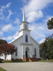 | Whitesburg Baptist Church | 2.5 miles | 2002 |
| National Archives record | The nomination case file for reference 100012416 in Record Group 79. |
| Carroll County | All 17 listed properties in this county. |