 Block
From the record
One of 16 National Register listings published here for Elbert County · listed in 2015 · category: District.
Sources: the National Register database, National Park Service
Listed on the National Register of Historic Places in 2015.
One of 16 National Register listings published here for Elbert County · listed in 2015 · category: District.
Sources: the National Register database, National Park Service
Regional context, not property-specific evidence. The federal wildfire occurrence database lists 273 fires within 5 miles of Elberton Commercial Historic District (Boundary Increase and Additional Documentation) between 1992 and 2020, burning about 476 acres in total. 11 started naturally. 24 were recorded as arson. Distance is straight-line from the map coordinates, so a fire counted here may appear on a neighbouring settlement's page as well.
| Reported cause | Fires |
|---|---|
| Debris and open burning | 142 |
| Equipment and vehicle use | 29 |
| Arson/incendiarism | 24 |
| Smoking | 18 |
| Missing data/not specified/undetermined | 18 |
| Misuse of fire by a minor | 17 |
| Natural | 11 |
| Railroad operations and maintenance | 11 |
| Recreation and ceremony | 3 |
The most recent of them, most recent first, with the day each was reported and the service that recorded it.
| Date | Cause | Size | Reported by | Name on the report |
|---|---|---|---|---|
| 6 September 2009 | Debris and open burning | 9.1 acres | Georgia Forestry Commission | not named |
| 6 September 2007 | Missing data/not specified/undetermined | under an acre | Georgia Forestry Commission | not named |
| 6 September 2007 | Missing data/not specified/undetermined | under an acre | Georgia Forestry Commission | not named |
| 4 September 2009 | Debris and open burning | under an acre | Georgia Forestry Commission | not named |
| 4 September 2009 | Debris and open burning | 1.6 acres | Georgia Forestry Commission | not named |
| 4 September 1997 | Natural | 4.7 acres | Georgia Forestry Commission | not named |
| 30 September 2003 | Debris and open burning | under an acre | Georgia Forestry Commission | not named |
| 30 September 2003 | Debris and open burning | under an acre | Georgia Forestry Commission | not named |
Regional context, not property-specific evidence. The federal mineral resources record lists 15 workings within 5 miles of Elberton Commercial Historic District (Boundary Increase and Additional Documentation): 8 producers, 6 past producers, 1 prospect. 8 still produce. What was taken out: Granite, Stone, Crushed/Broken, Kaolin, Stone, Dimension. Distance is straight-line from the map coordinates, so a quarry counted here may appear on a neighbouring settlement's page as well.
| Where | Site | Commodity | Status | Recorded |
|---|---|---|---|---|
| Continental Quarry | Stone, Dimension | Past Producer | ||
| Mrs. Clem Kelley Prospect | Kaolin | Prospect | ||
| Childs Brothers Quarry | Stone, Crushed/Broken | Producer | ||
| Old Harper Quarry | Stone, Crushed/Broken | Past Producer | ||
| Adams Quarry | Granite | Producer | ||
| Beaver Dam Quarry | Granite | Past Producer | ||
| Coronet Quarry | Granite | Past Producer | ||
| Hedquist Pink Quarry Keystone Gr | Granite | Producer | ||
| Peerless Extra Blue Quarry | Granite | Producer | ||
| Pyramid Quarry | Granite | Producer |
Regional context, not property-specific evidence. The National Weather Service names Elberton, the town this property stands in, in 79 storm reports between 1994 and 2025: 40 thunderstorm wind, 30 hail, 4 flash flood, 3 tornado. The reports record 1 injury. Each account below is quoted exactly as the forecast office filed it, from the NOAA Storm Events Database, and each date opens the federal record of that event.
| When | Event | Place named | Harm | What the report says |
|---|---|---|---|---|
| September 2006 | Thunderstorm Wind | Elberton | 1 hurt | Widespread tree damage in locations in and around Elberton. There was also some light structural damage. A man was injured and knocked unconscious for a while when a tree fell on his vehicle. Power was out to much of the city for several hours. |
| March 2008 | Tornado (EF2) | Elberton | $100,000 | NWS survey found a tornado damage track in far southern and southeast Elbert County. The tornado, which was spawned from a supercell, touched down southeast of Fortsonia near the intersection of River Rd and Flatwoods Rd. As the tornado tracked east along River Rd, damage was mainly confined to trees and power lines. The tornado began to take on a more east/southeast track near the intersection of River Rd and Balchin Rd, remaining just north of the Wilkes County line. Intensification occurred just west of highway 79 near its intersection with Cooter Creek Rd. The tornado continued to track east southeast, snapping or uprooting numerous trees between Cooter Creek Rd and the Broad River. Two homes received heavy roof damage consistent with EF2 intensity on Bramblett Circle along the Broad River. A boat dock was also lifted and tossed 25 feet in this area. The tornado continued to blow down trees before finally lifting in Bobby Brown State Park in the extreme southeast corner of the county. |
| September 2004 | Flash Flood | Elberton | $25,000 | Intense rainfall rates associated with the remnants of Hurricane Jeanne resulted in rapid rises and flash flooding along small creeks and streams during the evening hours. Several bridges and roads were damaged. |
| September 2004 | Tornado (F1) | Elberton | $25,000 | This brief tornado caused damage mainly to trees and power lines. |
| August 1999 | Thunderstorm Wind | Elberton | $25,000 | no account filed |
| July 1997 | Thunderstorm Wind | Elberton | $20,000 | no account filed |
| July 2013 | Flood | North Elberton | $10,000 | Flood waters from Beaverdam Creek covered portions of the Red Minnow Fish Lodge, located off of Brewers Bridge Road. Some mobile homes were flooded in this area as well. |
| July 2008 | Thunderstorm Wind | Elberton | $10,000 | Numerous trees and power lines were blown down in and around Elberton. One tree fell on a house on Athens highway. |
| September 2020 | Flash Flood | North Elberton | $5,000 | A stream gauge on Beaverdam Creek north of Elberton exceeded its established flood stage after 2 to 3 inches of rain fell in around 12 hours. At this level, a couple of unpaved roads are inundated in the Dewy Rose community and the crawl space of a restaurant is flooded on Brewers Bridge Rd. In addition, county comms reported a tributary of Van Creek overflowed its banks and inundated Amberley Rd in the northeast part of the county. |
| October 2003 | Flash Flood | Elberton | $5,000 | As much as 6 inches of rain fell across northern Elbert County during the morning hours, which resulted in significant flash flooding across the area by early afternoon. Portions of several roads were washed out, as were some culverts. Other roads were blocked for some time due to flooded creeks. |
| March 2002 | Thunderstorm Wind | Elberton | $2,000 | Power lines were blown down and a railroad crossing gate was destroyed. |
| May 2004 | Thunderstorm Wind | Elberton | $1,000 | Some trees and power lines were blown down. |
| May 2002 | Thunderstorm Wind | Elberton | $1,000 | Some trees and powerlines were blown down. |
| June 2002 | Thunderstorm Wind | Elberton | $1,000 | Some trees and powerlines were blown down. |
| June 1994 | Thunderstorm Wind | Elberton | $500 | A few large trees were blown down by thunderstorm winds. |
| May 2025 | Hail | North Elberton | - | Public reported quarter size hail. |
| May 2024 | Hail | North Elberton | - | Ham radio operator reported quarter size hail near the intersection of Highways 368 and 77. |
| April 2024 | Thunderstorm Wind | Elberton | - | County comms reported three trees blown down in the city of Elberton. |
| August 2023 | Thunderstorm Wind | Elberton | - | County comms reported multiple trees blown down in the city of Elberton, with some on power lines. |
| June 2020 | Thunderstorm Wind | Elberton | - | County comms reported multiple trees blown down along the Highway 17 corridor from Elberton to near the Wilkes County line. |
| June 2020 | Thunderstorm Wind | North Elberton | - | County comms reported trees blown down along Cecchini and Brewers Bridge Rd power lines down along Harmony Rd and more trees down along Anderson Highway. |
| June 2019 | Thunderstorm Wind | Elberton | - | County comms reported numerous trees blown in areas just west and south of Elberton, including on Mineral Springs Rd and Fleming Rd Ext, on Bakers Ferry Rd at Edison Rd, on Washington Highway, and with 40 trees blown down along Wahatchee Creek Rd alone. |
| March 2017 | Thunderstorm Wind | Elberton | - | County comms and a spotter reported a few trees blown down from the west side of Elberton (Brookwood Cir), across the north part of Elberton to Ruckersville Rd. |
| November 2016 | Thunderstorm Wind | Elberton | - | Emergency manager reported a couple of trees blown down. |
| June 2014 | Thunderstorm Wind | Elberton | - | County comms reported multiple power lines blown down in the city. |
| June 2013 | Thunderstorm Wind | Elberton | - | Several trees were blown down on Fork Creek Rd. |
| May 2012 | Hail | Elberton | - | Penny size hail fell along highway 72 near Flatwoods Rd and Pearl Mill Rd. |
| July 2012 | Thunderstorm Wind | Elberton | - | Multiple trees were blown down in the Elberton area. |
| May 2011 | Thunderstorm Wind | Elberton | - | Trees and power lines were blown down throughout the county, with the Ruckersville area being especially hard hit. At least one tree fell on a home. |
| March 2008 | Thunderstorm Wind | Elberton | - | Trees down on power lines along highway 72. |
| March 2008 | Thunderstorm Wind | Elberton | - | Numerous trees down around Elberton. Also, a large tree was blown down 1 SW Dewy Rose around the same time. |
| June 2007 | Thunderstorm Wind | Elberton | - | Metal roof blown off of a building. |
| July 2006 | Thunderstorm Wind | Elberton | - | Numerous trees and power lines down in and around Elberton. Some trees fell on cars and houses. |
| July 2006 | Hail | Elberton | - | Nickel size hail along Lincoln Rd. |
| June 2004 | Thunderstorm Wind | Elberton | - | Several trees were blown down in and around Elberton. |
| August 2004 | Heavy Rain | Elberton | - | Heavy rainfall resulted in flooding of a few low spots and poor drainage areas. |
| July 2004 | Thunderstorm Wind | Elberton | - | Several trees were blown down along highway 368 near the South Carolina line. |
| November 2002 | Thunderstorm Wind | Elberton | - | Numerous trees were blown down. |
| November 2002 | Thunderstorm Wind | Elberton | - | Numerous trees were blown down at the Bobby Brown State Park. |
| September 2002 | Thunderstorm Wind | Elberton | - | Some trees were blown down. |
| March 2002 | Hail | Elberton | - | Pea to dime size hail was reported covering the ground. |
| July 2002 | Thunderstorm Wind | Elberton | - | Several trees were blown down. |
| December 2001 | Thunderstorm Wind | Elberton | - | 3 trees were blown down. |
| April 2009 | Hail | Elberton | - | no account filed |
| April 2009 | Hail | Elberton | - | no account filed |
| March 2008 | Hail | Elberton | - | no account filed |
| March 2008 | Hail | Elberton | - | no account filed |
| April 2006 | Hail | Elberton | - | no account filed |
| April 2005 | Hail | Elberton | - | no account filed |
| June 2005 | Hail | Elberton | - | no account filed |
| August 2003 | Hail | Elberton | - | no account filed |
| March 2003 | Hail | Elberton | - | no account filed |
| April 2003 | Hail | Elberton | - | no account filed |
| April 2003 | Flash Flood | Elberton | - | no account filed |
| April 2003 | Hail | Elberton | - | no account filed |
| May 2000 | Thunderstorm Wind | Elberton | - | no account filed |
| May 2000 | Hail | Elberton | - | no account filed |
| July 2000 | Thunderstorm Wind | Elberton | - | no account filed |
| July 1999 | Thunderstorm Wind | Elberton | - | no account filed |
| August 1999 | Thunderstorm Wind | Elberton | - | no account filed |
No historic map-sheet match is published for this property yet. That does not mean no map exists. This record needs a coordinate-quality review before it can be joined to a sheet boundary. Browse the county's mapped places while that work is pending.
Other National Register properties close enough to walk or drive between, ordered by distance from this one. Both positions come from the same geocoding pass that matched these properties to their map sheets.
| Photograph | Property | Distance | Listed |
|---|---|---|---|
 | Elberton Commercial Historic District | under 500 feet | 1982 |
 | Elbert County Courthouse | under 500 feet | 1980 |
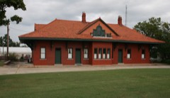 | Elberton Depot | 0.2 miles | 1986 |
 | Rock Gym | 0.3 miles | 1998 |
 | Elberton Residential Historic District | 0.3 miles | 1982 |
| Forest Avenue Historic District | 0.5 miles | 2015 |
| National Archives record | The nomination case file for reference 15000411 in Record Group 79. |
| Elbert County | All 16 listed properties in this county. |