 Block
From the record
One of 11 National Register listings published here for Stephens County · listed in 2015 · category: District.
Sources: the National Register database, National Park Service
Listed on the National Register of Historic Places in 2015.
One of 11 National Register listings published here for Stephens County · listed in 2015 · category: District.
Sources: the National Register database, National Park Service
Regional context, not property-specific evidence. The federal wildfire occurrence database lists 400 fires within 5 miles of Toccoa Downtown Historic District (Boundary Increase) between 1992 and 2019, burning about 1,292 acres in total. 6 started naturally. 86 were recorded as arson. Distance is straight-line from the map coordinates, so a fire counted here may appear on a neighbouring settlement's page as well.
| Reported cause | Fires |
|---|---|
| Debris and open burning | 179 |
| Arson/incendiarism | 86 |
| Equipment and vehicle use | 45 |
| Missing data/not specified/undetermined | 41 |
| Railroad operations and maintenance | 12 |
| Misuse of fire by a minor | 11 |
| Smoking | 10 |
| Recreation and ceremony | 7 |
| Natural | 6 |
| Power generation/transmission/distribution | 2 |
| Fireworks | 1 |
The most recent of them, most recent first, with the day each was reported and the service that recorded it.
| Date | Cause | Size | Reported by | Name on the report |
|---|---|---|---|---|
| 9 September 1999 | Equipment and vehicle use | under an acre | Georgia Forestry Commission | not named |
| 9 September 1999 | Railroad operations and maintenance | under an acre | Georgia Forestry Commission | not named |
| 7 September 2019 | Debris and open burning | 1.4 acres | Georgia Forestry Commission | FY2020STEPHENS001 |
| 5 September 1997 | Missing data/not specified/undetermined | under an acre | Georgia Forestry Commission | not named |
| 30 September 2003 | Missing data/not specified/undetermined | under an acre | Chattahoochee-Oconee National Forest | HIGHWAY 365#1,#2,#3 |
| 23 September 2016 | Debris and open burning | under an acre | Georgia Forestry Commission | FY2017-STEPHENS-001 |
| 18 September 2003 | Debris and open burning | 10 acres | Georgia Forestry Commission | not named |
| 18 September 2003 | Debris and open burning | under an acre | Georgia Forestry Commission | not named |
Regional context, not property-specific evidence. The federal mineral resources record lists 2 workings within 5 miles of Toccoa Downtown Historic District (Boundary Increase): 1 producer, 1 past producer. 1 still produces. What was taken out: Stone, Crushed/Broken. Distance is straight-line from the map coordinates, so a quarry counted here may appear on a neighbouring settlement's page as well.
| Where | Site | Commodity | Status | Recorded |
|---|---|---|---|---|
| Scott Brothers Quarry | Stone, Crushed/Broken | Past Producer | ||
| Toccoa Quarry | Stone, Crushed/Broken | Producer |
Regional context, not property-specific evidence. The National Weather Service names Toccoa, the town this property stands in, in 96 storm reports between 1993 and 2025: 58 thunderstorm wind, 29 hail, 4 flash flood, 2 tornado. No death or injury is recorded in these reports. Each account below is quoted exactly as the forecast office filed it, from the NOAA Storm Events Database, and each date opens the federal record of that event.
| When | Event | Place named | Harm | What the report says |
|---|---|---|---|---|
| April 2002 | Hail | Toccoa | $100,000 | no account filed |
| January 2023 | Lightning | Toccoa | $50,000 | Spotter reported a lightning strike ignited a house fire southeast of Toccoa. |
| June 1998 | Thunderstorm Wind | Toccoa | $50,000 | no account filed |
| April 2002 | Thunderstorm Wind | Toccoa | $25,000 | Numerous trees and power lines were reported down near Lake Hartwell. At least one tree fell onto a house. |
| April 2020 | Thunderstorm Wind | Toccoa | $20,000 | Ham radio operators reported many trees blown down throughout Stephens County, especially along Highways 123 and 328. A tree was also blown down onto a home along Century Dr near Lake Hartwell. |
| June 2015 | Thunderstorm Wind | Toccoa | $10,000 | County comms, spotter, and HAM radio operator reported multiple trees and large limbs blown down throughout Toccoa, including on Big A Rd and Collins Rd. Two trees fell on homes and a restaurant received minor roof damage. |
| August 2007 | Thunderstorm Wind | Toccoa | $10,000 | Several trees blown down, with 1 tree on a house, and another on a mobile home. The mobile home received some damage. |
| June 1994 | Tornado (F0) | Toccoa | $5,000 | A weak and short-lived tornado touched down near Georgia Highway 17 and downed several large trees. Most of the trees were uprooted or twisted at the base. |
| August 1993 | Thunderstorm Wind | Toccoa | $5,000 | Thunderstorm winds downed trees and power lines which caused scattered power outages throughout the county. |
| June 2004 | Thunderstorm Wind | Toccoa | $1,000 | Several trees were blown down onto power lines, causing some outages. |
| November 2003 | Tornado (F0) | Toccoa | $1,000 | This weak tornado blew down numerous limbs and trees along its intermittent 11-mile track. Part of a metal roof was blown off a building near Toccoa. |
| January 1998 | Thunderstorm Wind | Toccoa | $500 | no account filed |
| April 2025 | Hail | Toccoa | - | Multiple public sources reported (via Social Media) quarter size hail in the Toccoa area. |
| May 2023 | Thunderstorm Wind | Toccoa | - | County comms reported multiple trees blown down near the intersection of Rock Quarry Cir and W Currahee St. |
| June 2023 | Thunderstorm Wind | Toccoa | - | Ham radio operator reported multiple trees blown down. |
| August 2023 | Thunderstorm Wind | Toccoa | - | County comms reported a few trees and power lines blown down in the Toccoa area, and numerous trees down in Eastanolle and in Martin. |
| August 2021 | Thunderstorm Wind | Toccoa | - | Spotter reported trees blown down off Smith Rd. |
| April 2021 | Hail | Toccoa | - | Spotter reported dime to nickel size hail near Toccoa. |
| May 2019 | Thunderstorm Wind | Toccoa | - | County comms reported multiple trees blown down in Toccoa. |
| April 2018 | Hail | Toccoa | - | Media reported 3/4 inch hail in the Toccoa area. |
| May 2016 | Hail | Toccoa | - | Spotter reported pea to 3/4 inch hail. |
| August 2015 | Thunderstorm Wind | Toccoa | - | Spotter reported multiple trees and power lines blown down along Falls Rd in the vicinity of Toccoa and along Elberton St in south Toccoa. |
| January 2014 | Thunderstorm Wind | Toccoa | - | Power lines were blown down on West Currahee St about 1.5 miles southwest of Toccoa. |
| October 2014 | Thunderstorm Wind | Toccoa | - | County comms reported multiple trees and power lines blown down across central and eastern portions of the county. |
| May 2014 | Thunderstorm Wind | Toccoa | - | Spotter reported seven trees blown down along Fernside Dr. |
| July 2012 | Thunderstorm Wind | Toccoa | - | Multiple trees were blown down on Prather Bridge Rd. |
| August 2012 | Thunderstorm Wind | Toccoa | - | Several trees were blown down, mainly on the north side of town. |
| July 2012 | Thunderstorm Wind | Toccoa | - | A tree and a couple of power lines were blown down in the Toccoa area. |
| June 2011 | Thunderstorm Wind | Toccoa | - | Multiple trees and power lines were blown down along highway 17 in the Toccoa area. |
| July 2010 | Thunderstorm Wind | Toccoa | - | A large limb and power lines were blown down on the south side of the city. Trees were also blow down on Brookdale Rd, and on highway 123. |
| June 2010 | Thunderstorm Wind | Toccoa | - | A large tree was blown down on Currahee St, with another downed near the intersection of East Tugalo St and Alexander Rd. |
| September 2009 | Flash Flood | Toccoa | - | A small creek overflowed its banks, flooding Henrietta St and Poplar St in Toccoa. |
| July 2007 | Thunderstorm Wind | Toccoa | - | Trees down on Whispering Pines Dr. |
| April 2007 | Thunderstorm Wind | Toccoa | - | Damage to trees and power lines scattered across the county. |
| January 2007 | Thunderstorm Wind | Toccoa | - | A tree was blown down on Brookhaven Cir and another blown down on a power line on Prather Bridge Rd. |
| June 2007 | Thunderstorm Wind | Toccoa | - | Large limbs blown down and screens blown out of a porch. |
| August 2007 | Thunderstorm Wind | Toccoa | - | Several power lines and a large tree blown down around the city. |
| June 2007 | Thunderstorm Wind | Toccoa | - | Trees down in the Black Mountain area. |
| April 2006 | Hail | Toccoa | - | Hail was reported to be covering the ground. |
| July 2006 | Thunderstorm Wind | Toccoa | - | A tree blown down on Riverdale Rd and another down on highway 145 near the Franklin County line. |
| August 2006 | Thunderstorm Wind | Toccoa | - | Numerous trees blown down in and around Toccoa. One tree fell on a house on Poplar St. |
| August 2006 | Thunderstorm Wind | Toccoa | - | A tree down on W Silver Shoals Rd and another tree down on Prather Bridge Rd. |
| June 2005 | Thunderstorm Wind | Toccoa | - | Quite a few trees down in the Martin and Lake Hartwell area. |
| July 2005 | Flash Flood | Toccoa | - | Brief flooding of several small streams, with some road beds washed out. |
| July 2005 | Flash Flood | Toccoa | - | Severe urban flooding, with water up to porches and foundations of homes on Sycamore Circle and South Pond St. Several roads were closed due to high water. |
| August 2005 | Thunderstorm Wind | Toccoa | - | Trees down. |
| August 2005 | Thunderstorm Wind | Toccoa | - | Trees down on Ridgemore Rd, Brookhaven Circle, and Old Valley Rd near Lake Hartwell. Quite a few power lines were blown down in the area as well. |
| August 2005 | Thunderstorm Wind | Toccoa | - | Trees and power lines down along highway 123 in Ayersville. |
| August 2005 | Thunderstorm Wind | Toccoa | - | Trees down near Lake Hartwell. |
| July 2005 | Thunderstorm Wind | Toccoa | - | A couple trees down in the eastern part of the county. |
| June 2004 | Thunderstorm Wind | Toccoa | - | A couple of trees were blown down. |
| August 2004 | Thunderstorm Wind | Toccoa | - | Trees and power lines were blown down. |
| November 2004 | Thunderstorm Wind | Toccoa | - | Numerous trees blown down in Toccoa and elsewhere around the county. |
| July 2003 | Thunderstorm Wind | Toccoa | - | Trees were blown down along highway 320 and Walker Rd. |
| April 2003 | Hail | Toccoa | - | Hail accumulated to a depth of 3 inches. |
| May 2003 | Thunderstorm Wind | Toccoa | - | A power pole was blown down along highway 184. |
| June 2003 | Thunderstorm Wind | Toccoa | - | Several trees were blown down. |
| September 2002 | Thunderstorm Wind | Toccoa | - | Some trees and a power line were blown down at Yonah Lake. |
| August 2002 | Thunderstorm Wind | Toccoa | - | A couple of trees were blown down on the south side of town. |
| August 2002 | Thunderstorm Wind | Toccoa | - | Several trees were blown down. |
No historic map-sheet match is published for this property yet. That does not mean no map exists. This record needs a coordinate-quality review before it can be joined to a sheet boundary. Browse the county's mapped places while that work is pending.
Other National Register properties close enough to walk or drive between, ordered by distance from this one. Both positions come from the same geocoding pass that matched these properties to their map sheets.
| Photograph | Property | Distance | Listed |
|---|---|---|---|
 | Stephens County Courthouse | 0.1 miles | 1980 |
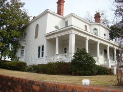 | James B. Simmons House | 0.1 miles | 1983 |
| Toccoa Downtown Historic District | 0.2 miles | 2011 | |
| Schaefer-Marks House | 0.4 miles | 1976 | |
| Walters-Davis House | 0.5 miles | 1982 | |
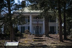 | Riverside | 4.9 miles | 1982 |
| National Archives record | The nomination case file for reference 15000744 in Record Group 79. |
| Stephens County | All 11 listed properties in this county. |