 Block
From the record
One of 6 National Register listings published here for Twiggs County · listed in 1982 · category: Building.
Sources: the case file at the National Archives · the National Register database, National Park Service
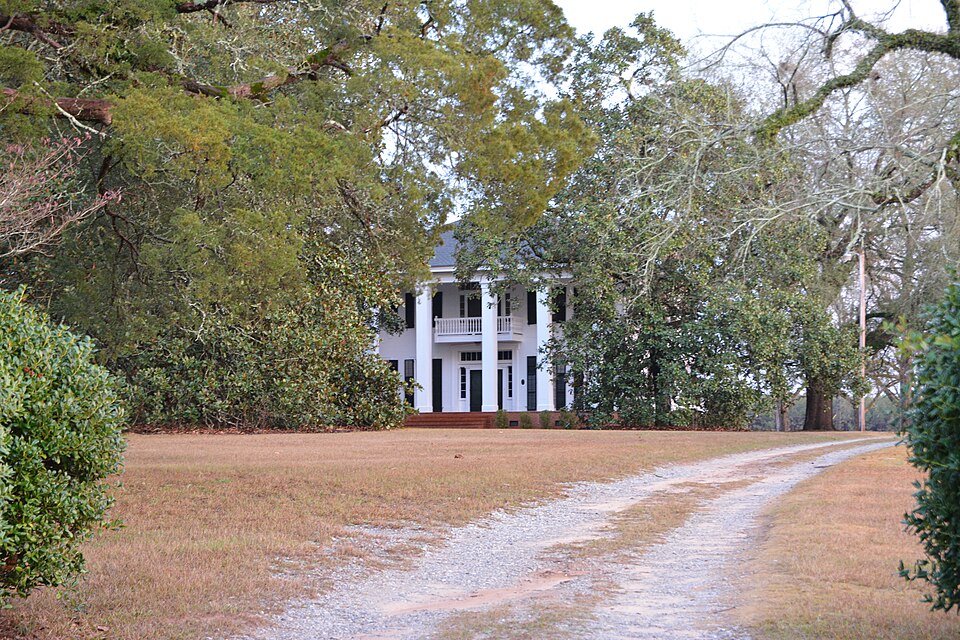
Listed on the National Register of Historic Places in 1982.
One of 6 National Register listings published here for Twiggs County · listed in 1982 · category: Building.
Sources: the case file at the National Archives · the National Register database, National Park Service
Regional context, not property-specific evidence. The federal wildfire occurrence database lists 511 fires within 5 miles of John Chapman Plantation between 1992 and 2020, burning about 1,198 acres in total. 17 started naturally. 48 were recorded as arson. Distance is straight-line from the map coordinates, so a fire counted here may appear on a neighbouring settlement's page as well.
| Reported cause | Fires |
|---|---|
| Debris and open burning | 271 |
| Equipment and vehicle use | 55 |
| Arson/incendiarism | 48 |
| Missing data/not specified/undetermined | 42 |
| Smoking | 29 |
| Misuse of fire by a minor | 25 |
| Natural | 17 |
| Recreation and ceremony | 13 |
| Railroad operations and maintenance | 11 |
The most recent of them, most recent first, with the day each was reported and the service that recorded it.
| Date | Cause | Size | Reported by | Name on the report |
|---|---|---|---|---|
| 8 September 1999 | Missing data/not specified/undetermined | under an acre | Georgia Forestry Commission | not named |
| 8 September 1995 | Debris and open burning | under an acre | Georgia Forestry Commission | not named |
| 6 September 2009 | Missing data/not specified/undetermined | under an acre | Georgia Forestry Commission | not named |
| 5 September 2009 | Misuse of fire by a minor | under an acre | Georgia Forestry Commission | not named |
| 4 September 1995 | Missing data/not specified/undetermined | under an acre | Georgia Forestry Commission | not named |
| 29 September 2016 | Debris and open burning | under an acre | Georgia Forestry Commission | FY2017-TWIGGS-007 |
| 28 September 1994 | Debris and open burning | under an acre | Georgia Forestry Commission | not named |
| 27 September 2013 | Recreation and ceremony | under an acre | Georgia Forestry Commission | FY2014-TWIGGS-002 |
Regional context, not property-specific evidence. The federal mineral resources record lists 5 workings within 5 miles of John Chapman Plantation: 4 producers, 1 occurrence. 4 still produce. What was taken out: Kaolin. Distance is straight-line from the map coordinates, so a quarry counted here may appear on a neighbouring settlement's page as well.
| Where | Site | Commodity | Status | Recorded |
|---|---|---|---|---|
| Jefferson Mine | Kaolin | Producer | ||
| Wall Mine | Kaolin | Producer | ||
| Watkins Mine | Kaolin | Occurrence | ||
| Watkins Mine | Kaolin | Producer | ||
| Watkins Pit | Kaolin | Producer |
Regional context, not property-specific evidence. The National Weather Service names Jeffersonville, the town this property stands in, in 51 storm reports between 1994 and 2026: 39 thunderstorm wind, 7 hail, 3 tornado, 2 lightning. No death or injury is recorded in these reports. Each account below is quoted exactly as the forecast office filed it, from the NOAA Storm Events Database, and each date opens the federal record of that event.
| When | Event | Place named | Harm | What the report says |
|---|---|---|---|---|
| April 2017 | Tornado (EF1) | Jeffersonville | $150,000 | A National Weather Service survey team found that an EF1 tornado with maximum wind speeds of 90 MPH and a maximum path width of 150 yards touched down along Highway 96 just south of Jeffersonville in far eastern Twiggs County. The tornado moved east directly across the Robins AFB WSR-88D radar location snapping a few softwood trees but not damaging to the radar tower. The tornado continued its track |east-southeast where it did its greatest amount of damage along US Highway 80. In this area there was roof damage to the Reece Funeral Home and several air conditioning units on the main roof were moved several feet. A few metal support cables on power poles were also broken. A nearby residence was damaged with the majority of shingles blown off the roof and part of a metal roof was blown off of a barn. Multiple large mature oak trees were uprooted on the property. The tornado continued east crossing Gallimore Mill Road and Buck creek before passing into Wilkinson County. No injuries were reported. [04/03/17: Tornado #20, County #1/2, EF-1, Twiggs, Wilkinson, 2017:052]. |
| June 2012 | Hail | Jeffersonville | $35,500 | Golf ball sized hail occurred near Highway 358 and Prospect Church Road not far from I-16. |
| April 2020 | Thunderstorm Wind | Jeffersonville | $10,000 | Multiple reports of trees and power lines down in the area of Soloman Road, off Hwy 80. |
| May 2019 | Thunderstorm Wind | Jeffersonville | $10,000 | Twiggs County EMA reported multiple trees down along I-16 near Hwy 96. |
| April 2017 | Thunderstorm Wind | Jeffersonville | $8,000 | The Macon area local broadcast media reported numerous trees blown down near the intersection of Bullard Road and Highways 80 and 96. |
| May 2020 | Thunderstorm Wind | Jeffersonville | $7,000 | The Twiggs County 911 center reported numerous trees blown down along Highway 96 Near Jeffersonville. |
| June 2017 | Thunderstorm Wind | Jeffersonville | $6,000 | The Twiggs County 911 center reported trees blown down bear the intersection of Missle Base Road and Hamlin-Floyd Road and on Highway 80 near the Turkey Creek bridge. |
| November 2014 | Thunderstorm Wind | Jeffersonville | $6,000 | The Twiggs County 911 Center reported numerous trees and power lines down countywide. |
| July 2008 | Thunderstorm Wind | Jeffersonville | $5,000 | The Twiggs County 911 Center reported that several trees and power lines were blown down along U.S. Highway 80 between Jeffersonville and Dry Branch. Radar data clearly showed a downburst in this area with base velocities in excess of 60 mph in this area. |
| March 2005 | Lightning | Jeffersonville | $5,000 | The Macon Telegraph reported that lightning struck outside a Huddle House restaurant and neighboring BP Oil Service Station. The lightning rendered the gasoline pump facility unusable. |
| August 1999 | Thunderstorm Wind | Jeffersonville | $5,000 | The public reported about 50 trees knocked down by thunderstorm winds between I-16 and highway 80. He said it looked like a tornado had come through. He also reported large hail about an inch in diameter. |
| June 1997 | Thunderstorm Wind | Jeffersonville | $5,000 | Numerous tree limbs were knocked down and several power lines were snapped countywide. |
| June 1994 | Thunderstorm Wind | Jeffersonville | $5,000 | Numerous trees were downed by thunderstorm winds along Georgia Highway 96. |
| August 2023 | Thunderstorm Wind | Jeffersonville | $3,000 | Several trees down in Jeffersonville. |
| July 2016 | Thunderstorm Wind | Jeffersonville | $3,000 | The Twiggs County 911 center reported trees blown down across the eastern portion of the county from north of Jeffersonville on Highway 18 to north of Danville along Jack Clay Road. |
| July 2015 | Thunderstorm Wind | Jeffersonville | $3,000 | The Twiggs County 911 Center reported trees blown down along Bullard Road. |
| June 2006 | Thunderstorm Wind | Jeffersonville | $3,000 | A deputy with the Twiggs County Sheriff's office reported that a few trees were down, mainly across the eastern portion of the county. The trees had brought down at least one power line. One large tree was also down in the city of Jeffersonville proper. |
| July 2000 | Thunderstorm Wind | Jeffersonville | $3,000 | The Twiggs county Sheriff reported trees down on Henderson Road. |
| May 2024 | Thunderstorm Wind | Jeffersonville | $2,000 | Trees were downed on highway 96 near the railroad tracks. |
| July 2023 | Thunderstorm Wind | Jeffersonville | $2,000 | Two trees down west of Jeffersonville. |
| July 2023 | Thunderstorm Wind | Jeffersonville | $2,000 | Report of two trees down on Glover Rd and Bullard Rd. |
| April 2020 | Thunderstorm Wind | Jeffersonville | $2,000 | A tree came down and took out power lines on the 1200 block of Main street, just outside of Jeffersonville. |
| March 2008 | Thunderstorm Wind | Jeffersonville | $2,000 | An amatuer radio operator reported that a couple of power lines and two to three trees were down along U.S. Highway 80 in the Jeffersonville area. |
| February 2003 | Thunderstorm Wind | Jeffersonville | $2,000 | The Twiggs county 911 center reported that several trees were down along U.S. Highway 80 around Jeffersonville. |
| April 1998 | Thunderstorm Wind | Jeffersonville | $2,000 | The sheriff's office reported several trees were downed on highway 80 by thunderstorm winds. |
| May 2014 | Thunderstorm Wind | Jeffersonville | $1,500 | The Twiggs County 911 Center reported that five trees were blown down. |
| June 2025 | Thunderstorm Wind | Jeffersonville | $1,000 | Tree limbs on SR 18 both directions at Balls Church Rd. All lanes closed. |
| August 2023 | Thunderstorm Wind | Jeffersonville | $1,000 | Tree down on ga hwy 80 at Turkey Creek Bridge. |
| July 2023 | Thunderstorm Wind | Jeffersonville | $1,000 | Tree down on Highway 96 and Prospect Rd. |
| September 2023 | Thunderstorm Wind | Jeffersonville | $1,000 | Tree down on Hwy 80 near the Turkey Creek Bridge. |
| March 2021 | Thunderstorm Wind | Jeffersonville | $1,000 | The Twiggs County Emergency Manager reported a tree blown down on Railroad Street in Jeffersonville. |
| April 2020 | Thunderstorm Wind | Jeffersonville | $1,000 | A tree was reported down at Balls Church and Hwy 18. |
| April 2020 | Thunderstorm Wind | Jeffersonville | $1,000 | Tree reported down at the intersection of Hwy 80 and Turkey Creek. |
| June 2014 | Thunderstorm Wind | Jeffersonville | $750 | The Twiggs County 911 Center reported that three trees had fallen onto roads, including Highway 80. |
| June 2014 | Thunderstorm Wind | Jeffersonville | $500 | The Twiggs County 911 Center reported trees down on Highway 18 at mile marker 2. |
| September 2011 | Lightning | Jeffersonville | $500 | The Twiggs County Emergency Management Director reported that lightning struck a tree near Jeffersonville, setting the tree on fire. |
| August 1997 | Thunderstorm Wind | Jeffersonville | $500 | Twiggs county 911 repored thunderstorm winds knocked down trees on Myrics Mill Road off highway 80 between Jeffersonville and Dry Branch. |
| August 1995 | Thunderstorm Wind | Jeffersonville | $400 | Thunderstorm winds knocked down several trees on the east side of town. Bibb County Macon,03,1525EST- *,,1625EST,,,0,0,1K,0,Thunderstorm Winds Thunderstorm winds blew down several large trees on the south side of the city. Power lines were also downed. |
| August 1995 | Thunderstorm Wind | Jeffersonville | $400 | Thunderstorm winds knocked down two large trees. |
| June 2005 | Thunderstorm Wind | Jeffersonville | $250 | The Twiggs County 911 Center reported that one tree was blown down. Several homes in the area were without power. |
| January 1995 | Thunderstorm Wind | Jeffersonville | $250 | Thunderstorm winds knocked down power lines and uprooted a tree at the intersection of Georgia Highway 358 and Georgia Highway 96. |
| March 2026 | Tornado (EF1) | Jeffersonville | - | As the line of thunderstorms continued into east-central Georgia, a tornado developed in central Twiggs county, several miles to the southwest of the city of Jeffersonville at 7:25 AM EDT. A tornado debris signature was observed from the KJGX radar at this|time. The first discernible damage was observed along I-16 Westbound, where a tree was snapped and another was uprooted to the immediate north of the interstate. The tornado continued east, snapping several pine trees at the end of Green Rd. Continuing to the south of Green Rd, it then crossed Hwy 96 where another pine tree was snapped. Between 7:27 and 7:28 AM EDT it uprooted a few trees near the intersection of Missile Base Rd and Prospect Church Rd. The most significant damage was observed in a|field on the north side of Prospect Church Rd and across from Missile Base Rd and Hamlin Floyd Rd. Here, as many as 30-40 large trees were uprooted, with several hardwood trees also snapped in the midst of these uprooted trees. As the tornado continued eastward, it snapped a couple more pine trees on the north side of Prospect Church Rd. The last damage observed was to the west of Tommie Thompson, with the tornado appearing to have lifted by 7:29 AM. |
| July 2023 | Thunderstorm Wind | Jeffersonville | - | Emergency manager reports tree down on outbuilding and home on Maple Street between Park Street and Sage Grass Street. |
| April 2022 | Tornado (EF1) | Jeffersonville | - | A high-end EF1 tornado quickly tracked across far eastern Twiggs |into southwest Wilkinson County. At its strongest, along Hwy 96 |south of Jeffersonville, the tornado was roughly 1.5 miles south |of the KJGX WSR-88D Radar. In this Hwy 96 area, five homes were |damaged, including a corner section/garage area of one home |collapsed but the roof and exterior walls remained in tact. |Numerous trees around this property were either snapped (some near|the base) or uprooted. Across the street on the west side of Hwy |96, a manufactured home was pushed off its foundation with |significant roof and siding damage. Another home had part of its |roof and chimney collapse with significant loss of its roof |covering removed. As the tornado continued to cycle and track east toward the |Wilkinson County line, it encountered mainly rural areas and open |fields before crossing Hwy 80, about 2.3 miles southeast of |Jeffersonville. Several trees were seen snapped or uprooted with |minor roof/shingle damage to a small one-story home. On the |Wilkinson County side, damage picked back up between Sinclair |Drive and Old Macon Road. This was mainly tree damage with minor |structural damage to a home along with several property fences |blown down. Further northeast, multiple trees were snapped or |uprooted along McCue Road and Knightpond Road, just before turning|into Stuckey Road. Based on radar, additional damage (trees) was |likely along Pleasant Plains Church Road but that road was flooded|at the time of this ground survey. End point was placed just |beyond this road. [4/5/22: Tornado #10, County #1/2, EF-1, Twiggs/Wilkinson, 2022:013]. |
| June 2015 | Hail | Jeffersonville | - | The public reported that dime to quarter sized hail fell in Jeffersonville. |
| June 2006 | Hail | Jeffersonville | - | A deputy with the Twiggs County Sheriff observed nickel-sized hail. |
| May 2005 | Hail | Jeffersonville | - | The public reported nickel-sized hail on the southwest side of Jeffersonville. |
| April 2004 | Hail | Jeffersonville | - | A storm spotter reported golf ball-sized hail. |
| June 1998 | Thunderstorm Wind | Jeffersonville | - | TheTwiggs county sheriff's office reported dime size hail and large limbs down in the road. |
| August 1999 | Hail | Jeffersonville | - | no account filed |
| June 1998 | Hail | Jeffersonville | - | no account filed |
No historic map-sheet match is published for this property yet. That does not mean no map exists. This record needs a coordinate-quality review before it can be joined to a sheet boundary. Browse the county's mapped places while that work is pending.
Other National Register properties close enough to walk or drive between, ordered by distance from this one. Both positions come from the same geocoding pass that matched these properties to their map sheets.
| Photograph | Property | Distance | Listed |
|---|---|---|---|
| Pines, The | 2.5 miles | 2021 | |
 | Twiggs County Courthouse | 2.6 miles | 1980 |
| Wimberly Plantation | 4.4 miles | 1982 | |
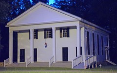 | Richland Baptist Church | 5.9 miles | 1982 |
| National Archives record | The nomination case file for reference 82002491 in Record Group 79. |
| Twiggs County | All 6 listed properties in this county. |