 Block
From the record
One of 24 National Register listings published here for Meriwether County · listed in 1984 · category: Building.
Sources: the case file at the National Archives · the National Register database, National Park Service
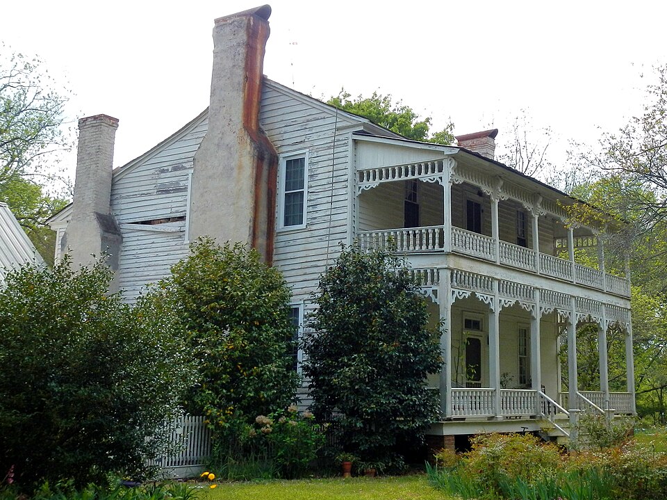
Listed on the National Register of Historic Places in 1984.
One of 24 National Register listings published here for Meriwether County · listed in 1984 · category: Building.
Sources: the case file at the National Archives · the National Register database, National Park Service
Regional context, not property-specific evidence. The federal wildfire occurrence database lists 135 fires within 5 miles of Jones-Florence Plantation between 1992 and 2020, burning about 984 acres in total. 8 started naturally. 16 were recorded as arson. Distance is straight-line from the map coordinates, so a fire counted here may appear on a neighbouring settlement's page as well.
| Reported cause | Fires |
|---|---|
| Debris and open burning | 75 |
| Arson/incendiarism | 16 |
| Missing data/not specified/undetermined | 10 |
| Equipment and vehicle use | 10 |
| Natural | 8 |
| Smoking | 7 |
| Recreation and ceremony | 4 |
| Misuse of fire by a minor | 3 |
| Railroad operations and maintenance | 2 |
The most recent of them, most recent first, with the day each was reported and the service that recorded it.
| Date | Cause | Size | Reported by | Name on the report |
|---|---|---|---|---|
| 9 September 1998 | Debris and open burning | 1.6 acres | Georgia Forestry Commission | not named |
| 29 September 2001 | Smoking | under an acre | Georgia Forestry Commission | FY2002-MERIWETHER-004 |
| 26 September 2011 | Debris and open burning | 3.4 acres | Georgia Forestry Commission | FY2012-MERIWETHER-009 |
| 20 September 1997 | Smoking | 1.5 acres | Georgia Forestry Commission | not named |
| 19 September 1997 | Debris and open burning | under an acre | Georgia Forestry Commission | not named |
| 17 September 1999 | Debris and open burning | 4.2 acres | Georgia Forestry Commission | not named |
| 16 September 2010 | Recreation and ceremony | under an acre | Georgia Forestry Commission | FY2011-MERIWETHER-004 |
| 5 August 2014 | Debris and open burning | 3.0 acres | Georgia Forestry Commission | FY2015-TROUP-001 |
Regional context, not property-specific evidence. The federal mineral resources record lists 1 working within 5 miles of Jones-Florence Plantation: 1 past producer. None of them still produces. What was taken out: Granite. Distance is straight-line from the map coordinates, so a quarry counted here may appear on a neighbouring settlement's page as well.
| Where | Site | Commodity | Status | Recorded |
|---|---|---|---|---|
| The Oddessa Quarry | Granite | Past Producer |
Regional context, not property-specific evidence. The National Weather Service names Odessadale, the town this property stands in, in 5 storm reports between 2009 and 2023: 3 thunderstorm wind, 2 tornado. The reports record 4 injuries. Each account below is quoted exactly as the forecast office filed it, from the NOAA Storm Events Database, and each date opens the federal record of that event.
| When | Event | Place named | Harm | What the report says |
|---|---|---|---|---|
| January 2023 | Tornado (EF2) | Odessadale | 4 hurt | Re-cycling from a parent supercell tracking from Chambers County (Alabama) into Troup County (Georgia), this tornado touched down just south of Callaway Airport, snapping several trees along Pegasus Pkwy. Damage quickly picked up just to the northeast approaching Whitesville Road (just north of I-85) where several one-story metal buildings had significant roof damage, along with their garage doors and windows blown in. Numerous trees in this area were either snapped or uprooted. Several power poles along Orchard Hill Road were broken off near the top. Maximum winds in this area were determined to be in the 90-100 mph range (EF-1). As the tornado continued northeast, a large warehouse building at the Vaughan Xpress transportation facility sustained significant damage. About 1/4 of the large warehouse was completely destroyed with several metal bolt anchors stretched or ripped up out of the concrete pad. Winds were estimated between 110-120 mph at this time and as it crossed I-85, a large number of trees were snapped (some near the base) or uprooted. Widespread significant damage by this strong tornado continued across the Baldwin Park community. In this location, more than 30 homes had significant damage; one and two-story homes lost major parts of the roof and upper level floors along with at least partial-collapse of exterior walls. Debris was thrown for hundreds of yards. Winds in this area likely maxed out around 120 mph, making this an EF-2 tornado. The tornado continued east-northeast, cutting down trees across Upper Big Springs Road, I-185, and Stewart Road (east of I-185). There's a fairly rural/wooded area between Stewart Road and the next road (Parmer road) about 2 miles apart but damage picked back up along Hwy 109/Greenville Road (mostly trees snapped/uprooted). The tornado then ripped through the town of Mountville, snapping and uprooting multiple medium to large trees along Trippe and College streets. A couple more trees were uprooted along Wood Road as it moved into Meriwether County. Numerous trees were down near the intersection of Keith Rd and Evans road as the damage veered right. The tornado continued across a wood area, crossing Beech Creek, with more large branches found snapped on Wilbur Keith Rd near Fox Den Rd. The giant mesocyclone continued east where the tornado merged with the ongoing Meriwether/Northwest Pike tornado near Highway 100 and Forrest Rd. |
| May 2009 | Thunderstorm Wind | Odessadale | $25,000 | The Meriwether County Sheriff's Office reported that three trees were blown down in the Greenville area. One of the trees fell on a home causing damage to the structure. |
| August 2020 | Thunderstorm Wind | Odessadale | $10,000 | The Meriwether County 911 center reported several trees blown down across the southwestern portion of the county from west of Greenville to northwest of Warm Springs. |
| May 2021 | Thunderstorm Wind | Odessadale | $4,000 | The Meriwether County 911 center reported a few trees blown down near Highway 109 and Harman Road. |
| January 2023 | Tornado (EF2) | Odessadale | - | Just west of the Troup-Meriwether County line, another long-track and powerful tornado formed just east of the county line near Keith Rd 0.9 miles north of GA109. The tornado initially traveled north then turned to a east-northeast direction crossing Wilbur Keith Rd and Piney Woods Rd downing hundreds of trees. The tornado broadened and intensified as it approached GA100 with a diameter of 0.9 miles and winds over 100 mph uprooting and snapping over 1000 trees. A home on Forrest Rd had its entire roof blown off where max winds were estimated at 120 mph and first reached EF-2 intensity. The tornado continued at 100 to 120 mph intensity as it continued east-northeast into neighborhoods south of Allie Rd along Mount Pilgram Rd where several homes were damaged or destroyed by trees falling on them. One double-wide manufactured home on Ground Hog Dr had its roof blown off and was shifted 20 yards off its foundation, breaking the home in half. The tornado continued east-northeast along Allie Rd crossing US27. Just east of US27 a very large stand of trees were snapped and a large recently-constructed two-story barn was destroyed. Just east of this location, two single-wide mobile home completely destroyed. The residents of one of the homes was at the hospital when the tornado struck and returned home early next morning to find it in shambles. Here, maximum winds were also rated at EF-2 intensity. The tornado began to weaken east of this point and it tracked a bit more northeast in direction, crossing Rocky Mountain Rd and Malcom Rd before it traveled along Callaway Rd downing several hundred more trees as it moved near the Alps community. While the tornado remained weak east of this area, the overall storm remained extremely strong and the tornado did not dissipate, continuing east paralleling HWY 362 causing sporadic tree damage before crossing the Flint River into NW Pike County crossing River RD and lifting around the Kings Bridge Road. Here winds were only 75-80 mph downing several trees as far as could be seen from public roadways. More recent analysis of radar data and areal satellite imagery confirmed that this particular circulation continued east into Pike County while 2 other tornadoes were spinning up to the North and Northeast of this weakening circulation. |
No historic map-sheet match is published for this property yet. That does not mean no map exists. This record needs a coordinate-quality review before it can be joined to a sheet boundary. Browse the county's mapped places while that work is pending.
Other National Register properties close enough to walk or drive between, ordered by distance from this one. Both positions come from the same geocoding pass that matched these properties to their map sheets.
| Photograph | Property | Distance | Listed |
|---|---|---|---|
 | Harman-Watson-Matthews House | 2.3 miles | 1973 |
 | Clarkland Farms | 5.2 miles | 1974 |
 | Burwell O. Hill House | 5.6 miles | 1982 |
| Hiram Warner Hill House | 5.7 miles | 1983 | |
 | Greenville Historic District | 6.1 miles | 1990 |
| Mark Hall | 6.1 miles | 1973 |
| National Archives record | The nomination case file for reference 84001163 in Record Group 79. |
| Meriwether County | All 24 listed properties in this county. |