 Block
From the record
One of 9 National Register listings published here for Cherokee County · listed in 1985 · category: Building.
Sources: the case file at the National Archives · the National Register database, National Park Service
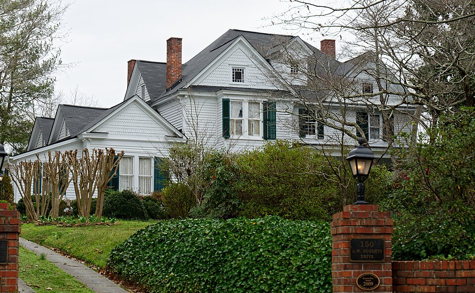
Listed on the National Register of Historic Places in 1985.
One of 9 National Register listings published here for Cherokee County · listed in 1985 · category: Building.
Sources: the case file at the National Archives · the National Register database, National Park Service
Regional context, not property-specific evidence. The federal wildfire occurrence database lists 351 fires within 5 miles of Alfred W. Roberts House between 1992 and 2020, burning about 701 acres in total. 6 started naturally. 139 were recorded as arson. Distance is straight-line from the map coordinates, so a fire counted here may appear on a neighbouring settlement's page as well.
| Reported cause | Fires |
|---|---|
| Arson/incendiarism | 139 |
| Debris and open burning | 132 |
| Missing data/not specified/undetermined | 19 |
| Equipment and vehicle use | 18 |
| Smoking | 18 |
| Misuse of fire by a minor | 8 |
| Recreation and ceremony | 8 |
| Natural | 6 |
| Railroad operations and maintenance | 3 |
The most recent of them, most recent first, with the day each was reported and the service that recorded it.
| Date | Cause | Size | Reported by | Name on the report |
|---|---|---|---|---|
| 9 September 2002 | Debris and open burning | under an acre | Georgia Forestry Commission | FY2003-PICKENS-017 |
| 8 September 2002 | Recreation and ceremony | under an acre | Georgia Forestry Commission | FY2003-CHEROKEE-007 |
| 5 September 1999 | Missing data/not specified/undetermined | under an acre | Georgia Forestry Commission | not named |
| 5 September 1997 | Arson/incendiarism | 1.2 acres | Georgia Forestry Commission | not named |
| 4 September 2010 | Debris and open burning | 1.5 acres | Georgia Forestry Commission | FY2011-CHEROKEE-004 |
| 26 September 1997 | Arson/incendiarism | under an acre | Georgia Forestry Commission | not named |
| 22 September 2005 | Smoking | under an acre | Georgia Forestry Commission | not named |
| 20 September 1998 | Recreation and ceremony | 1.5 acres | Georgia Forestry Commission | not named |
Regional context, not property-specific evidence. The federal mineral resources record lists 26 workings within 5 miles of Alfred W. Roberts House: 10 past producers, 8 prospects, 7 occurrences, 1 unknown. None of them still produces. What was taken out: Mica, Iron, Gold, Marble, Dimension. Distance is straight-line from the map coordinates, so a quarry counted here may appear on a neighbouring settlement's page as well.
| Where | Site | Commodity | Status | Recorded |
|---|---|---|---|---|
| Cochran Mine | Mica, Beryllium | Past Producer | ||
| Nelson Marble Prospect | Stone, Crushed/Broken | Occurrence | ||
| Unnamed Marble Quarry | Stone, Crushed/Broken | Past Producer | ||
| Lot 296 | Marble, Dimension | Occurrence | ||
| Marble Deposit Unnamed | Marble, Dimension | Occurrence | ||
| Mrs Stearne's Property | Marble, Dimension | Occurrence | ||
| Burty No.1 | Gold | Past Producer | Stream Placer | |
| Frank Burt Prospect | Gold | Prospect | ||
| Latham Mine | Gold | Past Producer | ||
| Lot 208 Shaft | Gold | Past Producer |
Regional context, not property-specific evidence. The National Weather Service names Ball Ground, the town this property stands in, in 37 storm reports between 1994 and 2025: 22 thunderstorm wind, 11 hail, 2 flash flood, 1 tornado. No death or injury is recorded in these reports. Each account below is quoted exactly as the forecast office filed it, from the NOAA Storm Events Database, and each date opens the federal record of that event.
| When | Event | Place named | Harm | What the report says |
|---|---|---|---|---|
| August 2013 | Flash Flood | Ball Ground | $60,000 | The Cherokee County emergency manager reported several drainage branches and creeks east of Ball Ground were overflowing their banks and flooding roads. Most of the flooding was associated with Long Swamp Creek and Conns Creek which was affecting Ball Ground Road and Conns creek road at Georgia Highway 372. Sperin Road near Conns Creek Road flooded with fire units only able to access the area from the Pickens County side. Several out buildings washed away or flooded along with a few vehicles off Conns Creek Road.. |
| February 2009 | Thunderstorm Wind | Ball Ground | $25,000 | The Cherokee County Emergency Management Director and the public reported that about 10 trees were down north through east of Canton. One tree was down on a house in Ball Ground. |
| July 2024 | Thunderstorm Wind | Ball Ground | $5,000 | Multiple trees down in the ball ground area . |
| May 2024 | Thunderstorm Wind | Ball Ground | $5,000 | Multiple trees were downed in the ball ground area including on Old Canton Rd at Old Nelson Rd, ball Ground Rd at Conns Creek Rd, and in the 2600 block of Conns Creek Rd. |
| July 2016 | Thunderstorm Wind | Ball Ground | $5,000 | The Cherokee County Emergency Manager reported trees blown down on Fairview Road off Ball Ground Highway, on Old Dawsonville Highway near Roy Haynes Drive, on Gilmer Ferry Road at Valley Street and at Ball Ground Highway and Howell Bridge Road. |
| July 2011 | Lightning | Ball Ground | $5,000 | The Cherokee County Emergency Management Director reported that lightning struck a home one mile east of Ball Ground. Damages were minor and confined to the electrical system. No fire was observed. |
| May 2003 | Flash Flood | Ball Ground | $5,000 | The Ball Ground Post Office reported that a number of roads in the area were flooded and impassable. |
| May 2001 | Thunderstorm Wind | Ball Ground | $5,000 | The public reported that power lines were down in Ball Ground. The Cherokee Tribune of Canton reported that winds blew down power lines and snapped off some trees, mainly in the Ball Ground area. Winds were estimated at 65 to 70 mph. |
| June 2001 | Thunderstorm Wind | Ball Ground | $5,000 | The Cherokee County Emergency Management Director reported that trees and power lines were down. There were several reports of tornadoes in the area, but there was never any confirmation of a touchdown. |
| August 2010 | Thunderstorm Wind | Ball Ground | $3,000 | The Cherokee County Emergency Management Director reported that the same thunderstorm downburst that began just north of Nelson in Pickens county continued south into extreme northern Cherokee county before dissipating. More than a dozen trees were down in the extreme northern part of the county north of Ball Ground, near the Pickens county line. |
| August 2007 | Thunderstorm Wind | Ball Ground | $3,000 | The Cherokee County 911 Center reported that several large trees were down in the northeast part of the county. |
| April 2020 | Thunderstorm Wind | Ball Ground | $2,000 | Tree down at the intersection of Hwy 372 and Conns Creek Road. |
| October 2010 | Thunderstorm Wind | Ball Ground | $2,000 | The Cherokee County Emergency Management Director reported that two trees were down just south of Ball Ground, one of which had taken out a power line on Ball Ground Highway. The road had to be closed until the downed power line could be repaired. Another tree was down just north of Holly Springs. This tree also took out a power line and blocked a road. |
| July 2004 | Thunderstorm Wind | Ball Ground | $2,000 | The public reported that a number of trees had been blown down by strong thunderstorm wind gusts. Winds gusts were estimated at 70 mph. |
| August 2024 | Thunderstorm Wind | Ball Ground | $1,000 | Tree down at reavis mountain rd and pickens st near city of nelson per em. |
| July 2024 | Thunderstorm Wind | Ball Ground | $1,000 | Tree down at Gilmer Ferry and Gazaway Lane . |
| June 2017 | Thunderstorm Wind | Ball Ground | $1,000 | The Cherokee County Emergency Manager reported a tree blown down near the intersection of Mineral Springs Road and Purcell Free Lane. |
| July 2017 | Thunderstorm Wind | Ball Ground | $1,000 | The Cherokee County Emergency Manager reported a tree blown down on Flatbottom Road. |
| May 2015 | Thunderstorm Wind | Ball Ground | $1,000 | Tree down blocking all lanes at Mineral Springs Road and Canton Highway in Ball Ground. Time estimated from radar. |
| June 2010 | Thunderstorm Wind | Ball Ground | $1,000 | The Cherokee County 911 Center reported that three to four trees were blown down within this time frame. |
| July 2004 | Tornado (F0) | Ball Ground | $1,000 | The Cherokee County Emergency Management Director conducted a damage survey and concluded that a short-lived, approximately 50-yard wide F0 tornado, developed in a rural area of dense woods and brush 3 miles east-northeast of Ball Ground and traveled along the ground for approximately 400 yards. The tornado crossed Cherry Grove Road near the end of its path. Damage was confined to trees and brush. The Emergency Management Director concluded that it was a tornado since there was definite indication of rotation in the woods where the damaged occurred. |
| June 1995 | Thunderstorm Wind | Ball Ground | $1,000 | Thunderstorm winds blew several trees down. |
| June 1998 | Thunderstorm Wind | Ball Ground | $500 | The public reported trees down. |
| May 2006 | Thunderstorm Wind | Ball Ground | $250 | The Cherokee County Emergency Management Director reported that one tree was blown down. |
| May 2025 | Thunderstorm Wind | Ball Ground | - | Public report of a snapped tree and a damaged shade structure near Flatbottom Rd and Clark Ln. |
| June 2022 | Thunderstorm Wind | Ball Ground | - | Tree reported down at the intersection of Gilmer Ferry Rd and Northridge Rd. |
| July 2018 | Hail | Ball Ground | - | The public reported quarter size hail in the 1500 block of Old Canton Road. |
| April 2016 | Hail | Ball Ground | - | An amateur radio operator reported penny size hail around Old Dawsonville Road and Jordan Road. |
| March 2008 | Hail | Ball Ground | - | The public reported nickel-sized hail in the Ball Ground area. |
| May 2006 | Hail | Ball Ground | - | The Cherokee County Emergency Management Director reported penny-sized hail. |
| July 2004 | Hail | Ball Ground | - | The public reported penny-sized hail. |
| June 2001 | Hail | Ball Ground | - | The public reported nickel size hail. |
| March 1999 | Hail | Ball Ground | - | The Cherokee county Civil Defense director reported dime size hail. |
| May 1998 | Hail | Ball Ground | - | no account filed |
| April 1997 | Hail | Ball Ground | - | no account filed |
| May 1997 | Hail | Ball Ground | - | no account filed |
| June 1994 | Hail | Ball Ground | - | no account filed |
No historic map-sheet match is published for this property yet. That does not mean no map exists. This record needs a coordinate-quality review before it can be joined to a sheet boundary. Browse the county's mapped places while that work is pending.
Other National Register properties close enough to walk or drive between, ordered by distance from this one. Both positions come from the same geocoding pass that matched these properties to their map sheets.
| Photograph | Property | Distance | Listed |
|---|---|---|---|
 | Ball Ground Historic District | 0.3 miles | 2009 |
| National Archives record | The nomination case file for reference 85002313 in Record Group 79. |
| Cherokee County | All 9 listed properties in this county. |