 Block
From the record
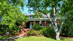
One of 36 National Register listings published here for Hart County · listed in 1986 · category: Building.
Sources: the case file at the National Archives · the National Register database, National Park Service
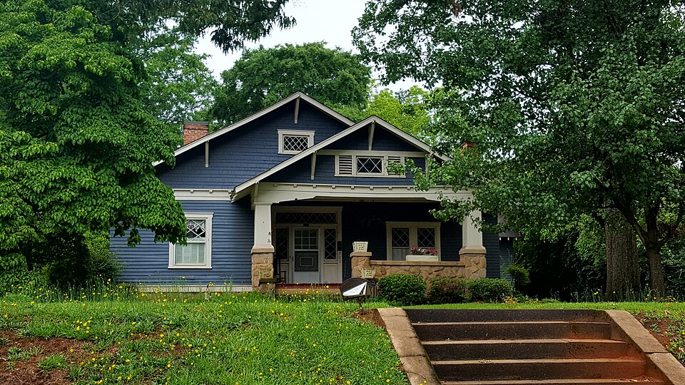
Listed on the National Register of Historic Places in 1986.
One of 36 National Register listings published here for Hart County · listed in 1986 · category: Building.
Sources: the case file at the National Archives · the National Register database, National Park Service
Regional context, not property-specific evidence. The federal wildfire occurrence database lists 162 fires within 5 miles of Kendrick-Matheson House between 1992 and 2020, burning about 264 acres in total. 2 started naturally. 18 were recorded as arson. Distance is straight-line from the map coordinates, so a fire counted here may appear on a neighbouring settlement's page as well.
| Reported cause | Fires |
|---|---|
| Debris and open burning | 105 |
| Arson/incendiarism | 18 |
| Equipment and vehicle use | 15 |
| Misuse of fire by a minor | 8 |
| Missing data/not specified/undetermined | 8 |
| Smoking | 4 |
| Natural | 2 |
| Recreation and ceremony | 2 |
The most recent of them, most recent first, with the day each was reported and the service that recorded it.
| Date | Cause | Size | Reported by | Name on the report |
|---|---|---|---|---|
| 9 September 1997 | Debris and open burning | 4.3 acres | Georgia Forestry Commission | not named |
| 30 September 2005 | Arson/incendiarism | under an acre | Georgia Forestry Commission | not named |
| 30 September 1993 | Debris and open burning | under an acre | Georgia Forestry Commission | not named |
| 24 September 1993 | Debris and open burning | under an acre | Georgia Forestry Commission | not named |
| 21 September 2001 | Debris and open burning | 1.2 acres | Georgia Forestry Commission | FY2002-HART-002 |
| 20 September 1997 | Debris and open burning | under an acre | Georgia Forestry Commission | not named |
| 19 September 2016 | Debris and open burning | under an acre | Georgia Forestry Commission | FY2017-HART-002 |
| 15 September 2010 | Debris and open burning | under an acre | Georgia Forestry Commission | FY2011-HART-003 |
Regional context, not property-specific evidence. The federal mineral resources record lists 16 workings within 5 miles of Kendrick-Matheson House: 10 occurrences, 6 past producers. None of them still produces. What was taken out: Mica, Gold, Feldspar. Distance is straight-line from the map coordinates, so a quarry counted here may appear on a neighbouring settlement's page as well.
| Where | Site | Commodity | Status | Recorded |
|---|---|---|---|---|
| Rowland Mine | Feldspar, Mica | Past Producer | ||
| Unknown, Prospect | Gold | Past Producer | Vein | |
| Bobo Deposit | Mica | Occurrence | ||
| Burco Deposit & R H Burns Deposit | Mica | Occurrence | ||
| Cole Deposit | Mica | Occurrence | ||
| H & P Mine & McKinney Mine | Mica | Past Producer | ||
| Isam Sanders Deposit | Mica | Occurrence | ||
| Old Parks Property Prospect | Mica | Occurrence | ||
| Ruth Jones Mine | Mica | Past Producer | ||
| Scott & Haley Deposit | Mica | Occurrence |
Regional context, not property-specific evidence. The National Weather Service names Hartwell, the town this property stands in, in 69 storm reports between 1993 and 2025: 45 thunderstorm wind, 20 hail, 2 flash flood, 1 tornado. The reports record 1 injury. Each account below is quoted exactly as the forecast office filed it, from the NOAA Storm Events Database, and each date opens the federal record of that event.
| When | Event | Place named | Harm | What the report says |
|---|---|---|---|---|
| August 1994 | Tornado (F1) | Hartwell | 1 hurt, $500,000 | A tornado touched down near the intersection of Moore and Hickory Crossing Roads, in the Cedar Creek Church community, halfway between Georgia Highways 77 and 172, in southcentral Hart County. The tornado destroyed two mobile homes, rolled a third over and lifted a fourth off its foundation in the Cedar Creek Church community. The tornado uprooted several large trees as it moved northwest across Scott Town Drive and lifted and dissipated near Landfill Road. Total damage to property was estimated at $320,000. |
| May 2002 | Thunderstorm Wind | Hartwell | $100,000 | Wind damage was reported to a house, a school, and a mobile home. Numerous trees and powerlines were also blown down, some onto vehicles and homes. |
| May 1994 | Thunderstorm Wind | Hartwell | $50,000 | Thunderstorm winds burst the windows of a mobile home and picked up and moved a well house. Three vehicles on Georgia Highway 172 were damaged from trees downed by thunderstorm winds. |
| March 2003 | Thunderstorm Wind | Hartwell | $5,000 | Winds estimated at 80 mph blew several tractor trailer trucks off of I-85 near the South Carolina border. |
| June 2002 | Thunderstorm Wind | Hartwell | $5,000 | A dock was damaged at Lake Hartwell. Several trees were also blown down. |
| May 1995 | Thunderstorm Wind | Hartwell | $2,000 | Thunderstorm winds knocked down at least one tree. Numerous downed tree limbs were also reported by 911 dispatchers. |
| July 2003 | Thunderstorm Wind | Hartwell | $1,000 | Trees and power lines were blown down. |
| November 2002 | Thunderstorm Wind | Hartwell | $1,000 | A tree and a power line were blown down. |
| April 2002 | Thunderstorm Wind | Hartwell | $500 | Four to five inch limbs were reported down. |
| January 1995 | Thunderstorm Wind | Hartwell | $100 | Thunderstorm winds knocked down several power lines. Small hail was reported as well. |
| March 1993 | Thunderstorm Wind | Hartwell | $4 | Thunderstorm winds produced minor damage to five homes and ripped off a tin roof from a barn in Hartwell. ~ Hart County 1 E Hartwell,31,2032EST,0.5,30,0,0,3,?,Tornado (F0) A short lived tornado touched down and toppled two large trees and blew over a farm shed. Two large columns that supported the front porch of a house were blown away. |
| July 2025 | Hail | Hartwell | - | Public reported nickel size hail. |
| February 2024 | Thunderstorm Wind | Hartwell | - | County comms reported a few trees blown down with one on power lines in the vicinity of Hartwell. |
| August 2023 | Thunderstorm Wind | Hartwell | - | County comms reported multiple trees blown down in the Hartwell area. |
| August 2023 | Thunderstorm Wind | Hartwell | - | County comms reported a tree blown down on Royston Highway and another tree down on Highway 172. |
| August 2019 | Hail | Hartwell | - | Public reported up to quarter size hail. |
| July 2018 | Thunderstorm Wind | Hartwell | - | County comms reported trees blown down in the Hartwell area. |
| November 2017 | Thunderstorm Wind | Hartwell | - | County comms reported a few trees blown down around Hartwell. |
| July 2017 | Thunderstorm Wind | Hartwell | - | Public reported numerous trees blown down along Ridge Road and Haven Drive. |
| June 2016 | Hail | Hartwell | - | Public reported penny size hail on Chandler St. |
| August 2015 | Thunderstorm Wind | Hartwell | - | County comms reported at least three trees blown down, mainly across the north and west side of Hartwell. |
| July 2013 | Thunderstorm Wind | Hartwell | - | Multiple trees were blown down in the southwest part of the county, with several trees blocking roads. |
| June 2012 | Thunderstorm Wind | Hartwell | - | Multiple trees were blown down at a campground on Watsadler Rd. |
| December 2009 | Flash Flood | Hartwell | - | Roads closed due to flooding included Shiloh Church Rd about 7 miles south of Hartwell, Page Rd about 3.5 miles southeast of town, and Heritage Rd on the south side of Lake Hartwell. Some flooding was the result of streams, some due to poor drainage. |
| March 2008 | Hail | Hartwell | - | Hail reportedly broke a car windshield. |
| March 2008 | Thunderstorm Wind | Hartwell | - | Trees down on Eagle School Rd near Eagle Grove and trees down on highway 172 near Bowman. |
| June 2008 | Thunderstorm Wind | Hartwell | - | Several trees were blown down along highway 172 south of Hartwell. |
| June 2007 | Hail | Hartwell | - | Reported along highway 29. |
| June 2007 | Thunderstorm Wind | Hartwell | - | Trees down near the intersection of Junction 77 Rd and Mt Olivet Rd. |
| June 2007 | Thunderstorm Wind | Hartwell | - | Windows broken out of a restaurant and signs blown down at a service station. Also, several trees were blown down. |
| May 2007 | Hail | Hartwell | - | Reported on Hanley Rd. |
| August 2007 | Thunderstorm Wind | Hartwell | - | A tree was blown down on Milltown Rd with large limbs blown down near the intersection of highway 51 and Boleman Hill Rd. |
| June 2006 | Thunderstorm Wind | Hartwell | - | Two power poles blown down on Reed Creek highway. |
| June 2006 | Thunderstorm Wind | Hartwell | - | Several trees blown down in the Shoal Creek area. |
| July 2006 | Thunderstorm Wind | Hartwell | - | Trees down along Bethany-Bowersville Rd and on Cedar Creek Circle. |
| June 2005 | Thunderstorm Wind | Hartwell | - | Quite a few trees down around Hart State Park. |
| July 2005 | Thunderstorm Wind | Hartwell | - | Numerous trees down, some on power lines. |
| August 2005 | Thunderstorm Wind | Hartwell | - | Trees and power lines down. |
| August 2005 | Thunderstorm Wind | Hartwell | - | Trees down. |
| June 2004 | Flash Flood | Hartwell | - | Cedar and Little Cedar Creeks overflowed their banks, flooding a portion of Almar Rd. |
| August 2004 | Thunderstorm Wind | Hartwell | - | Trees and power lines were blown down. |
| November 2004 | Thunderstorm Wind | Hartwell | - | Trees blown down across the county, but mainly in the south. |
| August 2003 | Thunderstorm Wind | Hartwell | - | Some trees were blown down. |
| May 2002 | Thunderstorm Wind | Hartwell | - | Some trees were blown down. |
| July 2002 | Hail | Hartwell | - | Hail was observed in the southeast part of town. |
| July 2001 | Thunderstorm Wind | Hartwell | - | Numerous trees and power lines downed 2 miles east of Royston. |
| July 2001 | Thunderstorm Wind | Hartwell | - | Trees blown down along Shoal Creek. |
| July 2001 | Thunderstorm Wind | Hartwell | - | Several trees blown down at a recreation area at Lake Hartwell. |
| May 1995 | Hail | Hartwell | - | Dime-size hail was reported in Bowersville by EMA officials. |
| May 2010 | Hail | Hartwell | - | no account filed |
| July 2008 | Hail | Hartwell | - | no account filed |
| June 2007 | Hail | Hartwell | - | no account filed |
| May 2006 | Hail | Hartwell | - | no account filed |
| May 2006 | Thunderstorm Wind | Hartwell | - | no account filed |
| May 2005 | Hail | Hartwell | - | no account filed |
| May 2005 | Hail | Hartwell | - | no account filed |
| August 2005 | Hail | Hartwell | - | no account filed |
| July 2004 | Hail | Hartwell | - | no account filed |
| May 2003 | Hail | Hartwell | - | no account filed |
| June 2000 | Hail | Hartwell | - | no account filed |
No historic map-sheet match is published for this property yet. That does not mean no map exists. This record needs a coordinate-quality review before it can be joined to a sheet boundary. Browse the county's mapped places while that work is pending.
Other National Register properties close enough to walk or drive between, ordered by distance from this one. Both positions come from the same geocoding pass that matched these properties to their map sheets.
| Photograph | Property | Distance | Listed |
|---|---|---|---|
 | Alexander Stephens Skelton House | under 500 feet | 1986 |
 | Temple-Skelton House | under 500 feet | 1986 |
 | Temple, John Roland, House | under 500 feet | 1986 |
 | Allie M. Best House | 0.1 miles | 1986 |
 | Roscoe Conklin Linder House | 0.2 miles | 1986 |
 | Adams-Matheson House | 0.2 miles | 1986 |
| National Archives record | The nomination case file for reference 86002029 in Record Group 79. |
| Hart County | All 36 listed properties in this county. |