 Block
From the record
One of 27 National Register listings published here for Coweta County · listed in 1989 · category: District.
Sources: the case file at the National Archives · the National Register database, National Park Service
Listed on the National Register of Historic Places in 1989.
One of 27 National Register listings published here for Coweta County · listed in 1989 · category: District.
Sources: the case file at the National Archives · the National Register database, National Park Service
Regional context, not property-specific evidence. The federal wildfire occurrence database lists 163 fires within 5 miles of Senoia Historic District between 1992 and 2019, burning about 859 acres in total. 5 started naturally. 16 were recorded as arson. Distance is straight-line from the map coordinates, so a fire counted here may appear on a neighbouring settlement's page as well.
| Reported cause | Fires |
|---|---|
| Debris and open burning | 97 |
| Arson/incendiarism | 16 |
| Misuse of fire by a minor | 11 |
| Recreation and ceremony | 11 |
| Missing data/not specified/undetermined | 10 |
| Equipment and vehicle use | 7 |
| Natural | 5 |
| Smoking | 4 |
| Railroad operations and maintenance | 2 |
The most recent of them, most recent first, with the day each was reported and the service that recorded it.
| Date | Cause | Size | Reported by | Name on the report |
|---|---|---|---|---|
| 7 September 2017 | Debris and open burning | under an acre | Georgia Forestry Commission | FY2018-COWETA-001 |
| 5 September 2004 | Recreation and ceremony | under an acre | Georgia Forestry Commission | not named |
| 18 September 1999 | Missing data/not specified/undetermined | 2.3 acres | Georgia Forestry Commission | not named |
| 16 September 2019 | Debris and open burning | 1.0 acres | Georgia Forestry Commission | FY2020COWETA004 |
| 8 August 2002 | Debris and open burning | 3.0 acres | Georgia Forestry Commission | FY2003-COWETA-003 |
| 7 August 2006 | Natural | 1.5 acres | Georgia Forestry Commission | not named |
| 30 August 1993 | Arson/incendiarism | 14 acres | Georgia Forestry Commission | not named |
| 29 August 1997 | Debris and open burning | under an acre | Georgia Forestry Commission | not named |
Regional context, not property-specific evidence. The federal mineral resources record lists 1 working within 5 miles of Senoia Historic District: 1 prospect. None of them still produces. What was taken out: Mica. Distance is straight-line from the map coordinates, so a quarry counted here may appear on a neighbouring settlement's page as well.
| Where | Site | Commodity | Status | Recorded |
|---|---|---|---|---|
| Porter Prospect | Mica | Prospect |
Regional context, not property-specific evidence. The National Weather Service names Senoia, the town this property stands in, in 36 storm reports between 1998 and 2025: 17 thunderstorm wind, 10 hail, 7 lightning, 1 tornado. No death or injury is recorded in these reports. Each account below is quoted exactly as the forecast office filed it, from the NOAA Storm Events Database, and each date opens the federal record of that event.
| When | Event | Place named | Harm | What the report says |
|---|---|---|---|---|
| August 2004 | Lightning | Senoia | $250,000 | The Times Herald of Newnan reported that lightning struck and set on fire a home on Rockhouse Road. While at first it was believed to be only a minor fire, the lightning apparently ignited a natural gas line in the home. Consequently, the home was a total loss. |
| June 2005 | Lightning | Senoia | $100,000 | The Times/Herald of Newnan reported that lightning struck and set on fire a one month old home in the Elders Mills Estates subdivision of Senoia. The home sustained major damage as a result of the fire. |
| January 2007 | Tornado (F0) | Senoia | $45,000 | A storm survey conducted by the National Weather Service in Peachtree City, GA confirmed that an F0 tornado had touched down along a patch beginning approximately two miles south-southwest of Senoia along Norton Road and continued on a northeastward track terminating at the intersection of Luther Bailey Road and Georgia Highway 16. A number of large trees were blown down along the path. A mobile home was destroyed and a car damaged by large downed trees at the intersection of Georgia Highway 16 and Luther Bailey Road. The tornado was rated an F0 at its maximum intensity with a maximum path width of 200 yards and a path length of approximately 1.5 miles. |
| July 2009 | Lightning | Senoia | $30,000 | The Times Herald of Newnan reported that lightning struck a home on Tudor Way off Rockaway Road. The resulting fire was contained mostly to the attic as it was quickly extinguished. |
| March 2000 | Lightning | Senoia | $25,000 | A lightning strike started a house fire on Pylant Street. No one was injured and firefighters were able to save most of the exterior of the home. |
| June 1998 | Thunderstorm Wind | Senoia | $20,000 | Public and spotter reports indicated trees were knocked down in several locations in and around Newnan. Some were blocking driveways and roads. Power and cable TV lines were downed also. One fell on an occupied car. Some shingles were blown off of a roof in Senoia. |
| August 2023 | Thunderstorm Wind | Senoia | $10,000 | Numerous trees blown down around Senoia and the surrounding areas in SE Coweta county. Heavily impacted locations include Gordon Rd, Dead Oak Rd, and along hwys 85 and 16. |
| December 2024 | Thunderstorm Wind | Senoia | $5,000 | Multiple trees down at Ga 16 and Georgian Pines Dr. |
| March 2005 | Lightning | Senoia | $5,000 | The Times Herald of Newnan reported that lightning struck a home on Dolly Nixon Road causing damage to the electrical system, but little other damage. |
| June 2001 | Lightning | Senoia | $5,000 | The Newnan Times Herald reported that a lightning strike to a house on Wagon Wheel Trail cut a "big hole" in the roof. There was no fire or smoke damage and damage was limited to the hole torn in the roof. |
| July 2016 | Thunderstorm Wind | Senoia | $2,000 | The public reported several trees blown down in Senoia. |
| May 2013 | Thunderstorm Wind | Senoia | $2,000 | The Coweta County 911 Center reported that several trees and power lines were blown down in the Senoia area. |
| January 2012 | Thunderstorm Wind | Senoia | $2,000 | Senoia Police and the Coweta County Emergency Manager reported that one tree was blown down near Howard Road and another at the entrance to the Willow Dale Subdivision. Minor wind damage occurred at a recreational baseball field, including a score board and dugout shelters. There was also minor damage sustained to the porch of the nearby senior center. |
| March 2025 | Thunderstorm Wind | Senoia | $1,000 | Tree down across chestlehurst road . |
| June 2023 | Thunderstorm Wind | Senoia | $1,000 | Tree reported down on Standing Rock Rd between Hugh Brown Rd and Toonerville Rd. |
| June 2023 | Thunderstorm Wind | Senoia | $1,000 | Report of tree down along Seavy St. |
| August 2023 | Thunderstorm Wind | Senoia | $1,000 | Tree down at Bridge St and Seavy St . |
| June 2023 | Thunderstorm Wind | Senoia | $1,000 | Tree down at the 600 block of Seavy Street. |
| November 2022 | Thunderstorm Wind | Senoia | $1,000 | Report of power lines down near the 500 block of Rock-a-way Rd. |
| April 2020 | Thunderstorm Wind | Senoia | $1,000 | Large tree down on the 10000 block of E Hwy 16. |
| April 2016 | Thunderstorm Wind | Senoia | $1,000 | The public reported a tree blown down in Senoia. |
| January 2000 | Thunderstorm Wind | Senoia | $1,000 | The public reported a few trees knocked down by thunderstorm winds. |
| June 2013 | Thunderstorm Wind | Senoia | $250 | The Coweta County 911 Center reported that a tree was blown down along Luther Bailey Road. |
| March 2023 | Hail | Senoia | - | Quarter size hail reported near the intersection of Werner Way and Seavy St. |
| June 2023 | Hail | Senoia | - | Report of 1 inch hail at intersection of Seavy Street and Werner Way. |
| July 2016 | Hail | Senoia | - | The public reported quarter size hail in Senoia. |
| May 2015 | Thunderstorm Wind | Senoia | - | Multiple trees down at the intersection of Gordon Road and Al Roberts Road. Additional trees down along Seavy Street, near Highway 85. |
| March 2015 | Hail | Senoia | - | The public reported quarter to half dollar sized hail in Senoia. |
| December 2014 | Heavy Rain | Senoia | - | NWS employee reported a 24-hour rainfall total of 2.10 inches. |
| March 2011 | Hail | Senoia | - | The public observed quarter-sized hail west of Senoia. This was from a second a weaker storm that tracked across southern Coweta county in the wake of the large, damaging baseball to grapefruit-size hail storm that tracked across the southern part of Coweta county one hour prior. |
| July 2011 | Hail | Senoia | - | The public observed quarter-sized hail near Senoia. WSR-88D radar data suggests that hail of similar size likely continued toward Haralson before the storm weakened. |
| June 2010 | Hail | Senoia | - | The public observed penny-sized hail just north of Senoia. |
| October 2002 | Lightning | Senoia | - | The Newnan Times-Herald reported that lightning struck a home in Senoia, but no monetary damage was reported. |
| May 1999 | Hail | Senoia | - | The public reported quarter size hail. |
| March 1998 | Hail | Senoia | - | Quarter size hail was reported in Senoia. Golfball size hail was reported in Moreland a few minutes later, apparently from a second storm. A funnel was also reported in the Moreland area. |
| June 1998 | Hail | Senoia | - | no account filed |
No historic map-sheet match is published for this property yet. That does not mean no map exists. This record needs a coordinate-quality review before it can be joined to a sheet boundary. Browse the county's mapped places while that work is pending.
Other National Register properties close enough to walk or drive between, ordered by distance from this one. Both positions come from the same geocoding pass that matched these properties to their map sheets.
| Photograph | Property | Distance | Listed |
|---|---|---|---|
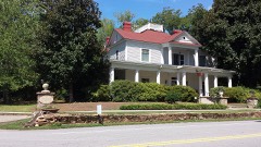 | Hollberg Hotel | under 500 feet | 1980 |
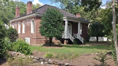 | Tidwell-Amis-Haynes House | 7.1 miles | 1997 |
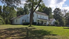 | Dr. Robert L. and Sarah Alberta Smith House | 7.6 miles | 1996 |
| National Archives record | The nomination case file for reference 89000149 in Record Group 79. |
| Coweta County | All 27 listed properties in this county. |