 Block
From the record
One of 24 National Register listings published here for Bulloch County · listed in 1993 · category: District.
Sources: the case file at the National Archives · the National Register database, National Park Service
Listed on the National Register of Historic Places in 1993.
One of 24 National Register listings published here for Bulloch County · listed in 1993 · category: District.
Sources: the case file at the National Archives · the National Register database, National Park Service
Regional context, not property-specific evidence. The federal wildfire occurrence database lists 261 fires within 5 miles of Stewart Stores between 1992 and 2020, burning about 1,254 acres in total. 15 started naturally. 34 were recorded as arson. Distance is straight-line from the map coordinates, so a fire counted here may appear on a neighbouring settlement's page as well.
| Reported cause | Fires |
|---|---|
| Debris and open burning | 182 |
| Arson/incendiarism | 34 |
| Natural | 15 |
| Missing data/not specified/undetermined | 11 |
| Equipment and vehicle use | 7 |
| Recreation and ceremony | 6 |
| Smoking | 3 |
| Misuse of fire by a minor | 3 |
The most recent of them, most recent first, with the day each was reported and the service that recorded it.
| Date | Cause | Size | Reported by | Name on the report |
|---|---|---|---|---|
| 7 September 2010 | Debris and open burning | under an acre | Georgia Forestry Commission | FY2011-BULLOCH-001 |
| 29 September 1993 | Debris and open burning | under an acre | Georgia Forestry Commission | not named |
| 22 September 2001 | Debris and open burning | under an acre | Georgia Forestry Commission | FY2002-BULLOCH-008 |
| 21 September 2019 | Debris and open burning | 1.3 acres | Georgia Forestry Commission | FY2020BULLOCH009 |
| 20 September 2010 | Debris and open burning | under an acre | Georgia Forestry Commission | FY2011-BULLOCH-004 |
| 19 September 2001 | Debris and open burning | 2.3 acres | Georgia Forestry Commission | FY2002-BULLOCH-007 |
| 18 September 2011 | Missing data/not specified/undetermined | 5.8 acres | Georgia Forestry Commission | FY2012-BULLOCH-015 |
| 12 September 2018 | Natural | 2.1 acres | Georgia Forestry Commission | FY2019BULLOCH004 |
Regional context, not property-specific evidence. The National Weather Service names Portal, the town this property stands in, in 33 storm reports between 1993 and 2025: 21 thunderstorm wind, 10 hail, 1 funnel cloud, 1 tornado. No death or injury is recorded in these reports. Each account below is quoted exactly as the forecast office filed it, from the NOAA Storm Events Database, and each date opens the federal record of that event.
| When | Event | Place named | Harm | What the report says |
|---|---|---|---|---|
| April 2011 | Thunderstorm Wind | Portal | $75,000 | An emergency manager reported that four structures received damage with multiple trees down near the intersection of Pecan Grove Road and CL Woods Road. One Church had steeple and porch damage. One mobile home was rolled over and destroyed. One tree fell on another home. One house had a front porch collapse. All damage was due to straight line winds. |
| April 2011 | Thunderstorm Wind | Portal | $37,500 | Law enforcement reported a destroyed mobile home on Pecan Grove Road. |
| May 1993 | Thunderstorm Wind | Portal | $5,000 | Numerous trees and tree limbs were blown down from thunderstorm winds. |
| June 2023 | Thunderstorm Wind | Portal | $1,250 | A Bulloch County emergency manager reported power lines down along the 400 Block of Johnson Street. |
| June 2009 | Thunderstorm Wind | Portal | $1,000 | Law enforcement reported a tree down near the intersection of Willow Hill Road and Westside Road. |
| June 2007 | Thunderstorm Wind | Portal | $1,000 | Two trees were reported down on Willow Hill Road. |
| October 2010 | Thunderstorm Wind | Portal | $500 | Law enforcement reported a tree down in Portal, Georgia. |
| June 2009 | Thunderstorm Wind | Portal | $500 | Law Enforcement reported a tree down along Westside Road near Portal Road, 10 miles west-northwest of Statesboro, Georgia. |
| July 2008 | Thunderstorm Wind | Portal | $500 | The Bulloch County warning point reported an oak tree down on Claudia Street in downtown Portal, Georgia. |
| July 2007 | Thunderstorm Wind | Portal | $100 | Small tree limbs were reported down near Portal with winds estimated around 40 mph. |
| July 2025 | Thunderstorm Wind | Portal | - | Bulloch County Emergency Management reported a tree down at the intersection of Metter Road and Westside Road. |
| June 2025 | Thunderstorm Wind | Portal | - | The Bulloch County 911 Call Center reported a tree down on Cowboy Way. |
| May 2022 | Thunderstorm Wind | Portal | - | A trained spotter reported a tree down near the intersection of Metter Road and Brack Road. |
| April 2020 | Thunderstorm Wind | Portal | - | A trained spotter measured a 62 mph wind gust. |
| March 2019 | Hail | Portal | - | A picture on Facebook was relayed by the broadcast media of hail up to the size of quarters in Portal. |
| June 2019 | Hail | Portal | - | A trained spotter reported hail the size of ping pong balls near the intersection of Metter Road and Banks Dairy Road. |
| June 2019 | Thunderstorm Wind | Portal | - | A trained spotter reported multiple trees and tree limbs down along Metter Road near the intersection with Banks Dairy Road. |
| May 2014 | Thunderstorm Wind | Portal | - | A mobile home on Ben Grady Collins Road had windows blown out due to a thunderstorm wind gust. Skirting was also ripped off the mobile home and a tricycle was blown into a tree. |
| June 2008 | Hail | Portal | - | A report of nickel size hail was received from Lake Collins, Georgia. The hail lasted for around 5 minutes. |
| September 2004 | Tornado (F0) | Portal | - | A weak tornado knocked trees and large limbs down. |
| February 2003 | Thunderstorm Wind | Portal | - | Numerous trees, large limbs, power lines and highway signs were down. |
| March 2003 | Thunderstorm Wind | Portal | - | Several trees were down. |
| March 2001 | Thunderstorm Wind | Portal | - | Large limbs down and damage to a building. |
| April 1999 | Funnel Cloud | Portal | - | Two funnel clouds sighted by the public. |
| May 2014 | Hail | Portal | - | no account filed |
| May 2007 | Hail | Portal | - | no account filed |
| July 2005 | Thunderstorm Wind | Portal | - | no account filed |
| July 2002 | Hail | Portal | - | no account filed |
| May 1999 | Hail | Portal | - | no account filed |
| May 1999 | Hail | Portal | - | no account filed |
| April 1999 | Hail | Portal | - | no account filed |
| May 1998 | Hail | Portal | - | no account filed |
| June 1998 | Thunderstorm Wind | Portal | - | no account filed |
No historic map-sheet match is published for this property yet. That does not mean no map exists. This record needs a coordinate-quality review before it can be joined to a sheet boundary. Browse the county's mapped places while that work is pending.
Other National Register properties close enough to walk or drive between, ordered by distance from this one. Both positions come from the same geocoding pass that matched these properties to their map sheets.
| Photograph | Property | Distance | Listed |
|---|---|---|---|
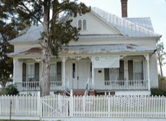 | Dr. James A. Stewart House | 0.1 miles | 1993 |
 | Upper Lott's Creek Primitive Baptist Church and Cemetery | 4.1 miles | 2008 |
| National Archives record | The nomination case file for reference 93000430 in Record Group 79. |
| Bulloch County | All 24 listed properties in this county. |