 Block
From the record
One of 9 National Register listings published here for Polk County · listed in 1995 · category: Building.
Sources: the case file at the National Archives · the National Register database, National Park Service · the Wikipedia article
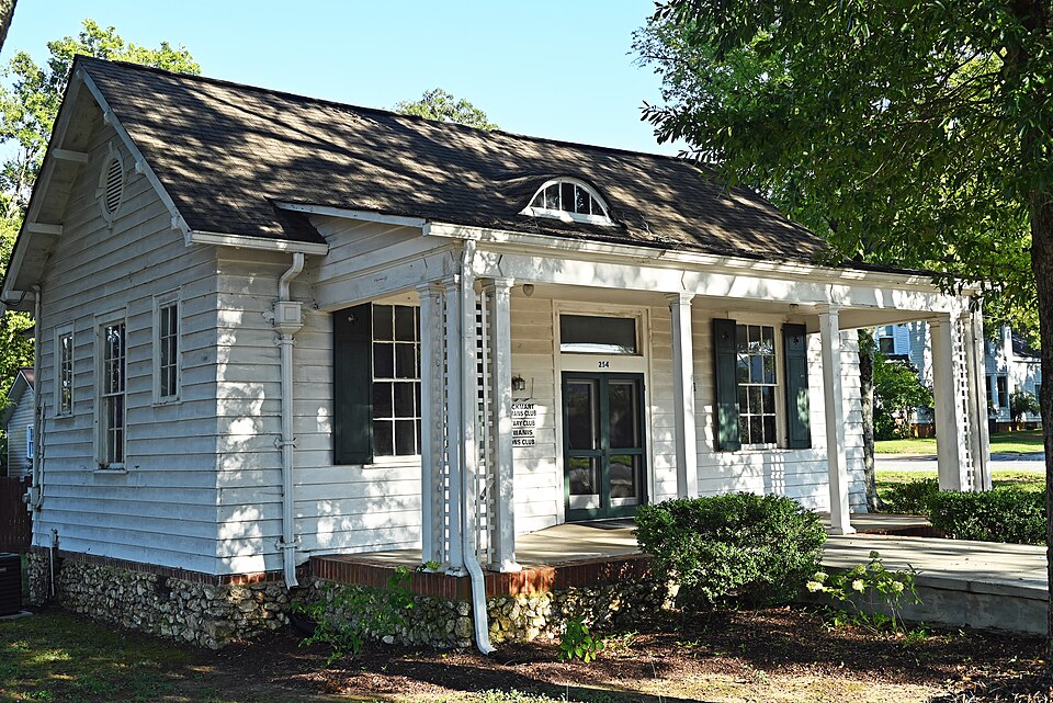
Listed on the National Register of Historic Places in 1995.
One of 9 National Register listings published here for Polk County · listed in 1995 · category: Building.
Sources: the case file at the National Archives · the National Register database, National Park Service · the Wikipedia article
Regional context, not property-specific evidence. The federal wildfire occurrence database lists 363 fires within 5 miles of Rockmart Woman's Club between 1992 and 2019, burning about 1,682 acres in total. 2 started naturally. 177 were recorded as arson. Distance is straight-line from the map coordinates, so a fire counted here may appear on a neighbouring settlement's page as well.
| Reported cause | Fires |
|---|---|
| Arson/incendiarism | 177 |
| Debris and open burning | 114 |
| Railroad operations and maintenance | 24 |
| Equipment and vehicle use | 13 |
| Missing data/not specified/undetermined | 13 |
| Misuse of fire by a minor | 13 |
| Recreation and ceremony | 7 |
| Natural | 2 |
The most recent of them, most recent first, with the day each was reported and the service that recorded it.
| Date | Cause | Size | Reported by | Name on the report |
|---|---|---|---|---|
| 9 September 2007 | Equipment and vehicle use | under an acre | Georgia Forestry Commission | not named |
| 7 September 1997 | Debris and open burning | under an acre | Georgia Forestry Commission | not named |
| 6 September 1993 | Arson/incendiarism | 2.9 acres | Georgia Forestry Commission | not named |
| 30 September 2019 | Debris and open burning | 2.0 acres | Georgia Forestry Commission | FY2020POLK012 |
| 29 September 2016 | Debris and open burning | under an acre | Georgia Forestry Commission | FY2017-POLK-017 |
| 27 September 1998 | Arson/incendiarism | under an acre | Georgia Forestry Commission | not named |
| 26 September 2019 | Debris and open burning | under an acre | Georgia Forestry Commission | FY2020POLK011 |
| 26 September 1999 | Arson/incendiarism | under an acre | Georgia Forestry Commission | not named |
Regional context, not property-specific evidence. The federal mineral resources record lists 16 workings within 5 miles of Rockmart Woman's Club: 11 past producers, 5 producers. 5 still produce. What was taken out: Iron, Stone, Crushed/Broken, Clay, Sand and Gravel, Construction. Distance is straight-line from the map coordinates, so a quarry counted here may appear on a neighbouring settlement's page as well.
| Where | Site | Commodity | Status | Recorded |
|---|---|---|---|---|
| Rockmart | Bloating Material | Producer | Sedimentary | |
| Rockmart Cement Mill | Stone | Producer | ||
| Silica Quarry No. 2 | Sand and Gravel, Construction | Producer | ||
| Rockmart Shale Quarry | Clay | Past Producer | ||
| Rockmart Shale Quarry | Clay | Producer | ||
| Braswell Quarry | Stone, Crushed/Broken | Producer | ||
| Piedmont Portland Cement Co Quarry | Stone, Crushed/Broken | Past Producer | ||
| Rockmart Quarry | Stone, Crushed/Broken | Past Producer | ||
| Southern States Portland Cmnt Co Qy | Stone, Crushed/Broken | Past Producer | ||
| Green Bank | Iron | Past Producer | Residual |
Regional context, not property-specific evidence. The National Weather Service names Rockmart, the town this property stands in, in 38 storm reports between 1994 and 2025: 20 thunderstorm wind, 9 hail, 4 lightning, 2 tornado. The reports record 4 injuries. Each account below is quoted exactly as the forecast office filed it, from the NOAA Storm Events Database, and each date opens the federal record of that event.
| When | Event | Place named | Harm | What the report says |
|---|---|---|---|---|
| April 2006 | Tornado (F2) | Rockmart | 1 hurt, $450,000 | A survey conducted by the National Weather Service in Peachtree City, GA concluded that a second tornado, this one an F2, touched down one mile northwest of Rockmart and traveled to the east approximately three miles, terminating at a point around two miles east-northeast of Rockmart. Over two dozen homes along the path of the tornado were destroyed. A young child was injured at one of the damaged homes when sheet rock and rafters fell on the couch where he was sleeping. Over three dozen outbuildings were also heavily damaged or destroyed. A carport was blown off one home northwest of Rockmart and five coal cars were completely blown off a railroad track in the Rockmart area and left lying on their side, while an 18-wheel truck trailer was also blown over in the same general area. Finally, minor damage was reported to the roof of the Rockmart Highschool and especially to the athletic fields. Hundreds of trees and dozens of power lines were blown down along the path of the tornado. A total of 700 residents were left without power for many hours following the storm. The tornado was determined to have a path length of approximately 3.0 miles with a path width of 50 to 100 yards.Overall tornado damage from the two tornadoes in Polk county netted:30 homes with minor damage.2 homes destroyed.60 outbuildings heavily damaged or destroyed.Minor damage to the Rockmart Highschool and athletic facility.700 customers without power.Extensive loss to timber in the area |
| August 2014 | Thunderstorm Wind | Rockmart | 1 hurt, $10,000 | The 911 Center reported numerous trees down in the eastern part of the county, especially near Rockmart. The Emergency Manager reported a tree down on a house. The occupant of the house suffered a head injury and was transported to the hospital. Another house had its roof partially blown off. A subdivision on Lakeview Drive had numerous trees and power lines down. |
| June 1994 | Tornado (F0) | Rockmart | 1 hurt, $500 | A weak and short-lived tornado touched down along U.S. Highway 278 three miles west of Rockmart. A few pine trees were uprooted or snapped half-way up from the crown. The one injury resulted from wind blown debris. |
| July 2005 | Lightning | Rockmart | 1 hurt | The Cedartown Standard reported that a 13-year old boy was injured when lightning struck at his father's home while he was typing on a computer. The boy was treated and released at a local hospital. |
| February 2009 | Lightning | Rockmart | $150,000 | The Rockmart Journal reported that lightning struck an unoccupied historic Victorian structure located at 120 Catherine Street. The interior of the structure was damaged from the resulting fire. |
| August 2007 | Lightning | Rockmart | $50,000 | The Polk County Fire & Rescue Department reported that lightning struck and set on fire a home on Old Cedartown Road at Morgan Valley Road. One tree was also blown down three miles east-southeast of Rockmart along Springdale Road. |
| February 2001 | Lightning | Rockmart | $25,000 | The Polk county Emergency Management Directory reported that lightning set a house on fire. The specific amount of damage was unknown. |
| February 2008 | Thunderstorm Wind | Rockmart | $15,000 | The Polk County Emergency Management Director reported that a tree fell on a house on Maple Street. The house sustained moderate damage as a result. |
| April 2009 | Thunderstorm Wind | Rockmart | $5,000 | The public reported that a portion of the siding and part of the roof was blown off an apartment building. |
| November 2004 | Thunderstorm Wind | Rockmart | $5,000 | The Polk County 911 Center reported that several trees were down, some on power lines. |
| November 2001 | Thunderstorm Wind | Rockmart | $5,000 | The Polk county 911 center reported that three signs were blown down and two trees, one a large tree, either side of Rockmart along U.S. Highway 278. |
| May 2024 | Thunderstorm Wind | Rockmart | $3,000 | Several trees down on Smith St . |
| July 2002 | Thunderstorm Wind | Rockmart | $3,000 | The public reported that numerous trees were blown down on a farm west of Rockmart. An amateur radio operator reported that several tree limbs were blown down on power lines in Rockmart. |
| June 2025 | Thunderstorm Wind | Rockmart | $2,000 | Tree down on powerlines and blocking roadway near intersection of College St and Central St. |
| May 2013 | Flash Flood | Rockmart | $2,000 | The public reported several drainage branches and small creeks from Rockmart to near Taylorsville overflowed their banks. This affected low lying portions of a few roads which caused temporary road closures. |
| July 2002 | Thunderstorm Wind | Rockmart | $2,000 | An amateur radio operator reported that three trees were blown down, one landing on the roof of a home located just west of Rockmart off U.S. Highway 278, while yet another tree fell down on the roof of an old store in Fish Creek. |
| April 2001 | Thunderstorm Wind | Rockmart | $2,000 | The Polk county 911 center reported several large tree limbs down across power lines. |
| June 1998 | Thunderstorm Wind | Rockmart | $2,000 | The public reported golf ball size hail and several trees down. |
| May 1997 | Thunderstorm Wind | Rockmart | $2,000 | A couple of large trees were downed by thunderstorm winds, and several power lines were snapped in the Fish Creek area. |
| March 2025 | Thunderstorm Wind | Rockmart | $1,000 | Tree down on williamson st in rockmart . |
| March 2025 | Thunderstorm Wind | Rockmart | $1,000 | Tree down on goodyear ave . |
| June 2025 | Thunderstorm Wind | Rockmart | $1,000 | Tree down across roadway on 1300 block of Hutchings Mountain Rd. |
| May 2024 | Thunderstorm Wind | Rockmart | $1,000 | Em reports a tree down on powerlines on Morgan Valley Rd between 4th St and Old Cedartown in Rockmart. |
| July 1995 | Thunderstorm Wind | Rockmart | $1,000 | Thunderstorm winds knocked down numerous trees throughout the county as well as several trees and powerlines within the city of Rockmart. |
| August 2023 | Thunderstorm Wind | Rockmart | - | Roof torn off building, multiple trees down, and tree on structure in Rockmart area. |
| January 2023 | Thunderstorm Wind | Rockmart | - | Report of tree down on Wilson Rd between Sewell Creed Rd and Fields Rd. |
| March 2023 | Thunderstorm Wind | Rockmart | - | Report of a tree down on powerlines on Morgan Valley Rd. |
| August 2021 | Flash Flood | Rockmart | - | The Emergency Manager reported a partial wash out of Morgan Valley Road at Hillside Drive due to flash flooding in the area. Radar estimates indicate that 2 to 3 inches of rain occurred over the area, causing the flash flooding. |
| April 2008 | Hail | Rockmart | - | The Polk county Emergency Management Director reported that half-dollar-sized hail fell for over five minutes across the northeast part of Polk county between Rockmart and areas east of Aragon. |
| June 2006 | Hail | Rockmart | - | The public reported penny-sized hail. |
| October 2005 | Hail | Rockmart | - | The public reported penny-sized hail in Rockmart. The Aragon Police Department reported pea-sized hail in Aragon. |
| November 2002 | Hail | Rockmart | - | An amateur radio operator reported dime size hail. |
| July 2002 | Hail | Rockmart | - | An amateur radio operator reported dime size hail. |
| September 2000 | Flood | Rockmart | - | The Polk county 911 center reported that high water on U.S. Highway 278 and Georgia Highway 113 caused several accidents. No damage estimate was provided. |
| May 1999 | Hail | Rockmart | - | There were several reports of hail ranging from nickel to half dollar size. |
| February 1998 | Hail | Rockmart | - | Dime size hail was reported by Polk county 911. |
| April 1997 | Hail | Rockmart | - | no account filed |
| June 1997 | Hail | Rockmart | - | no account filed |
No historic map-sheet match is published for this property yet. That does not mean no map exists. This record needs a coordinate-quality review before it can be joined to a sheet boundary. Browse the county's mapped places while that work is pending.
Other National Register properties close enough to walk or drive between, ordered by distance from this one. Both positions come from the same geocoding pass that matched these properties to their map sheets.
| Photograph | Property | Distance | Listed |
|---|---|---|---|
| Rockmart Downtown Historic District | 1.1 miles | 2009 | |
| Euharlee Elementary School | 1.3 miles | 2026 |
| National Archives record | The nomination case file for reference 95000738 in Record Group 79. |
| Wikipedia article | Community-written account of this property, licensed CC BY-SA. |
| Polk County | All 9 listed properties in this county. |