 Block
From the record
One of 17 National Register listings published here for Barrow County · listed in 1998 · category: District.
Sources: the case file at the National Archives · the National Register database, National Park Service
Listed on the National Register of Historic Places in 1998.
One of 17 National Register listings published here for Barrow County · listed in 1998 · category: District.
Sources: the case file at the National Archives · the National Register database, National Park Service
Regional context, not property-specific evidence. The federal wildfire occurrence database lists 108 fires within 5 miles of Statham Historic District between 1992 and 2020, burning about 284 acres in total. 3 started naturally. 10 were recorded as arson. Distance is straight-line from the map coordinates, so a fire counted here may appear on a neighbouring settlement's page as well.
| Reported cause | Fires |
|---|---|
| Debris and open burning | 54 |
| Arson/incendiarism | 10 |
| Missing data/not specified/undetermined | 10 |
| Misuse of fire by a minor | 10 |
| Equipment and vehicle use | 9 |
| Recreation and ceremony | 6 |
| Smoking | 4 |
| Natural | 3 |
| Railroad operations and maintenance | 2 |
The most recent of them, most recent first, with the day each was reported and the service that recorded it.
| Date | Cause | Size | Reported by | Name on the report |
|---|---|---|---|---|
| 8 September 2008 | Equipment and vehicle use | under an acre | Georgia Forestry Commission | not named |
| 29 September 2016 | Debris and open burning | under an acre | Georgia Forestry Commission | FY2017-BARROW-004 |
| 29 September 2010 | Missing data/not specified/undetermined | under an acre | Georgia Forestry Commission | FY2011-JACKSON-005 |
| 28 September 2016 | Debris and open burning | 3.5 acres | Georgia Forestry Commission | FY2017-BARROW-003 |
| 12 September 2003 | Missing data/not specified/undetermined | under an acre | Georgia Forestry Commission | not named |
| 8 August 1999 | Recreation and ceremony | 6.4 acres | Georgia Forestry Commission | not named |
| 7 August 1995 | Arson/incendiarism | under an acre | Georgia Forestry Commission | not named |
| 29 August 1998 | Debris and open burning | 1.9 acres | Georgia Forestry Commission | not named |
Regional context, not property-specific evidence. The National Weather Service names Statham, the town this property stands in, in 14 storm reports between 1995 and 2023: 9 thunderstorm wind, 4 hail, 1 flash flood. The reports record 1 injury. Each account below is quoted exactly as the forecast office filed it, from the NOAA Storm Events Database, and each date opens the federal record of that event.
| When | Event | Place named | Harm | What the report says |
|---|---|---|---|---|
| August 2013 | Thunderstorm Wind | Statham | 1 hurt, $200,000 | The Barrow County Emergency Manager reported that nine trees were blown down, and two of them on houses. One of the trees on a house was on Nunnally Road, and the other on Soloman Drive. A resident on Nunnally Road had minor injuries, and the Red Cross was called for the Soloman Drive residence. |
| July 2019 | Thunderstorm Wind | Statham | $20,000 | Report of structural damage and trees down on the 1100 block of Baxter Court, south-southwest of Statham. Time estimated from radar. |
| June 2006 | Thunderstorm Wind | Statham | $10,000 | The Barrow County News reported that thunderstorm winds brought down a few large trees, one causing minor damage to a home and another bringing down a fence. A couple of power lines were also brought down by the fallen trees, leaving about 630 people without power for several hours during the evening. |
| September 1999 | Thunderstorm Wind | Statham | $2,500 | The public reported trees down all around Statham. One fell on a mobile home. |
| August 2023 | Thunderstorm Wind | Statham | $2,000 | Trees down around Glenn Jackson Road and Bogart Jefferson Road east of Statham. |
| July 2020 | Thunderstorm Wind | Statham | $1,000 | The public reported tree limbs blown down and damage to a trampoline and a wooden playset. |
| August 2020 | Thunderstorm Wind | Statham | $1,000 | The public reported a tree blown down across a driveway on Providence Circle. |
| July 1995 | Thunderstorm Wind | Statham | $500 | Thunderstorm winds blew several trees down. |
| March 2017 | Hail | Statham | - | Quarter size hail was reported on a farm along Finch Road. |
| May 2015 | Thunderstorm Wind | Statham | - | Trees down around Statham, near the intersection of Hammond Road and Rat Kinney Road. Time estimated from radar. |
| August 2009 | Hail | Statham | - | The public observed quarter-sized hail in the Statham area. |
| January 2007 | Hail | Statham | - | The public reported nickel-sized hail. Several tree limbs were also blown down in the area. |
| March 2003 | Flash Flood | Statham | - | National Weather Service automated river gages indicated that because of excessive rainfall on the order of 3 to 5 inches in 6-hours or less, the Middle Oconee River on the Jackson/Barrow county line rose from 5 feet or less to flood stage of 16 feet in less than six hours. The river then continued to rise and crested at 19.7 feet around 7 pm in the evening. Moderate flooding begins at 18 feet and major flooding occurs at 22 feet.. Residents in the area reported that the river was higher than they had seen in years. |
| April 1997 | Hail | Statham | - | no account filed |
No historic map-sheet match is published for this property yet. That does not mean no map exists. This record needs a coordinate-quality review before it can be joined to a sheet boundary. Browse the county's mapped places while that work is pending.
Other National Register properties close enough to walk or drive between, ordered by distance from this one. Both positions come from the same geocoding pass that matched these properties to their map sheets.
| Photograph | Property | Distance | Listed |
|---|---|---|---|
| Russell Homeplace Historic District | 6.2 miles | 1984 | |
| Manning Gin Farm | 6.6 miles | 1991 | |
| Downtown Winder Historic District (Boundary Increase) | 7.2 miles | 1994 | |
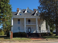 | North Broad Street Residential Historic District | 7.3 miles | 1984 |
| Jackson Street Commercial Historic District | 7.3 miles | 1984 | |
| Downtown Winder Historic District (Boundary Increase) | 7.4 miles | 1994 |
| National Archives record | The nomination case file for reference 98001521 in Record Group 79. |
| Barrow County | All 17 listed properties in this county. |