 Block
From the record
17 National Register listings published here.
Sources: the National Register database, National Park Service
44 topographic sheets and 5 fire insurance atlases across 1 place.
17 National Register listings published here.
Sources: the National Register database, National Park Service
Every property in this county listed on the National Register of Historic Places, with the year it was listed and the federal nomination document.
| Photograph | Property | Type | Listed | Reference |
|---|---|---|---|---|
| Athens-Candler-Church Street Historic District | district | 1986 | 86000799 | |
| Auburn Historic District | district | 1997 | 97000527 | |
 | Barrow County Courthouse | building | 1980 | 80000970 |
| Broad Street Commercial Historic District | district | 1984 | 84000884 | |
| Carlyle-Blakey Farm | site | 2008 | 08000353 | |
| Downtown Winder Historic District (Boundary Increase) | district | 1994 | 94000412 | |
| Downtown Winder Historic District (Boundary Increase) | district | 1994 | 94000412 | |
| Jackson Street Commercial Historic District | district | 1984 | 84000885 | |
 | Jackson-Johns House | building | 1985 | 85000847 |
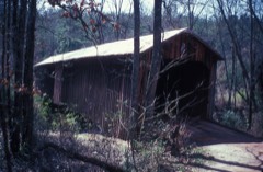 | Kilgore Mill Covered Bridge and Mill Site | structure | 1975 | 75000572 |
| Manning Gin Farm | district | 1991 | 91000541 | |
 | North Broad Street Residential Historic District | district | 1984 | 84000888 |
 | Omer Christian Church and Cemetery | building | 2000 | 00000074 |
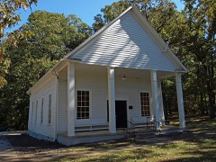 | Rockwell Universalist Church | building | 1985 | 85000933 |
| Russell Homeplace Historic District | district | 1984 | 84000890 | |
| Statham Historic District | district | 1998 | 98001521 | |
 | Winder Depot | building | 1979 | 79000696 |
Barrow County has 1 covered bridge on the National Register. Each is a listed structure with a federal nomination on file.
| Kilgore Mill Covered Bridge and Mill Site | Listed 1975 |
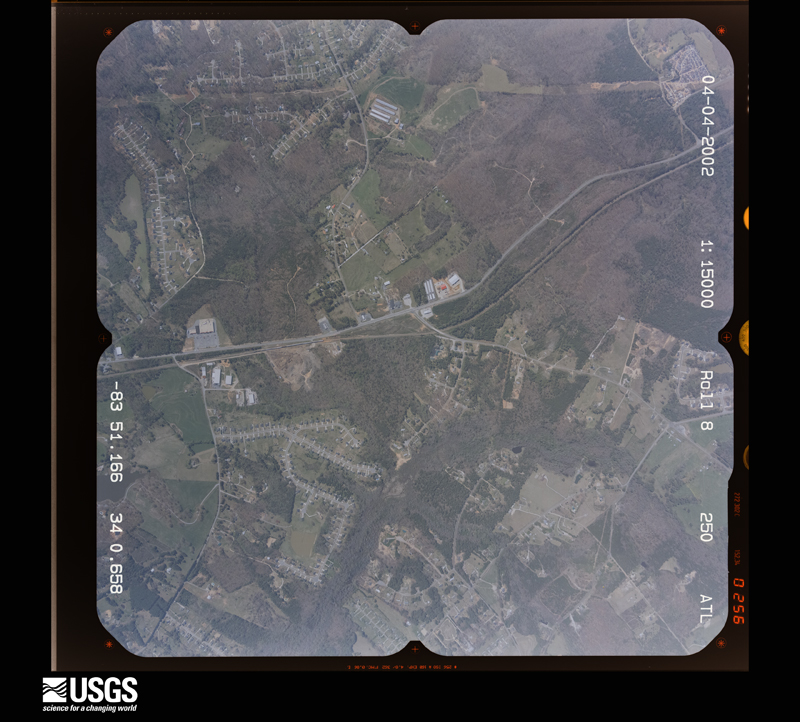
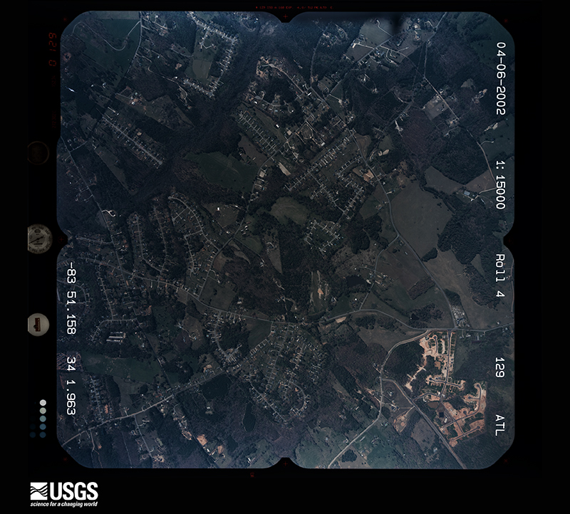
Flown by the U.S. Geological Survey between 1937 and 1989, the Aerial Photo Single Frames collection is the definitive mid-century view of the land: fields, roads and rivers as the camera saw them. The Survey holds 357 frames inside the rectangle that bounds this county; the 22 frames below were taken over the county itself, chosen across the decades of flights (at most four a year from that rectangle), so one flight cannot crowd out the rest. The full set is free to browse and download at EarthExplorer under the dataset Aerial Photo Single Frames.




















The thermometers that kept this county's weather, and the gages that measured the flow of its streams, as the federal records hold them. The extremes below are measured values from those records, not estimates.
Who lived here in 1950, one enumeration district at a time, as the Census Bureau described each district. Each row opens its official National Archives result, with Population Schedules and ED Maps available there.
Every wildfire the federal occurrence database records inside this county: 264 of them, burning about 612 acres. 11 started naturally and 44 were recorded as arson. Each settlement page carries the fires within five miles of it.
| Reported cause | Fires |
|---|---|
| Debris and open burning | 124 |
| Arson/incendiarism | 44 |
| Misuse of fire by a minor | 31 |
| Equipment and vehicle use | 19 |
| Missing data/not specified/undetermined | 15 |
| Natural | 11 |
| Smoking | 9 |
| Recreation and ceremony | 9 |
| Railroad operations and maintenance | 2 |
The five largest, by the area the report gives. Two of them were set deliberately.
| Date | Cause | Size | Reported by | Name on the report |
|---|---|---|---|---|
| 18 January 1999 | Debris and open burning | 38 acres | Georgia Forestry Commission | not named |
| 27 September 2003 | Arson/incendiarism | 26 acres | Georgia Forestry Commission | not named |
| 3 April 1995 | Arson/incendiarism | 23 acres | Georgia Forestry Commission | not named |
| 20 March 1995 | Debris and open burning | 22 acres | Georgia Forestry Commission | not named |
| 25 November 1993 | Natural | 20 acres | Georgia Forestry Commission | not named |
| 24 February 1995 | Debris and open burning | 19 acres | Georgia Forestry Commission | not named |
| 9 March 1993 | Missing data/not specified/undetermined | 16 acres | Georgia Forestry Commission | not named |
| 3 April 1997 | Debris and open burning | 16 acres | Georgia Forestry Commission | not named |
Every settlement page carries the fires within five miles of it - see the settlement index below.
The NOAA Storm Events Database holds 202 reports for this county, causing no deaths, 2 injuries and about $9,912,530 in recorded property damage. Each settlement page carries the reports that name it.
| Kind of event | Reports |
|---|---|
| Thunderstorm Wind | 112 |
| Hail | 58 |
| Lightning | 16 |
| Flash Flood | 7 |
| Tornado | 5 |
| Flood | 3 |
| Winter Storm | 1 |
The most serious of them, by death, then injury, then recorded damage. The accounts are quoted exactly as the forecast office filed them.
| When | Event | Place named | Harm | What the report says |
|---|---|---|---|---|
| March 1984 | Tornado (F1) | not stated | 1 hurt, $250,000 | no account filed |
| August 2013 | Thunderstorm Wind | Statham | 1 hurt, $200,000 | The Barrow County Emergency Manager reported that nine trees were blown down, and two of them on houses. One of the trees on a house was on Nunnally Road, and the other on Soloman Drive. A resident on Nunnally Road had minor injuries, and the Red Cross was called for the Soloman Drive residence. |
| July 2012 | Lightning | Winder | $3,000,000 | A historic church, built in 1904, was completely destroyed by a lightning strike and resulting fire at 71 West Candler Street. The church was the oldest in Winder and had recently undergone over $700,000 worth of restoration and renovation, with only $10,000 left of repairs to go before it was fully restored. As it was, the historic church was worth millions. Firefighters were able to contain the blaze to the church alone, although other homes along the block were evacuated as a precaution. |
| February 2005 | Hail | Thompsons Mill | $1,000,000 | Numerous reports of large hail were received from the Barrow County Emergency Management Director, the 911 center, and the public. Most of the hail fell within a narrow area along and near Georgia Highway 211 in the northwest part of the county from near its intersection with Interstate 85 to the city of County Line. The hail accumulated to a significant depth and still reported to be covering the roads several hours after the storm had passed. |
| April 2009 | Hail | Auburn | $900,000 | The public observed quarter to golf ball-sized hail in the far western part of Barrow county, especially in the Auburn area. They reported that it hailed for up to 10 minutes in the Auburn area. The public also reported nickel-sized hail in the Bethlehem area. |
| April 2009 | Hail | Winder | $900,000 | The Barrow County 911 Center reported golf ball-sized hail in the Winder area. |
| July 2008 | Hail | Auburn | $800,000 | Two separate embedded thunderstorms, less than 10 miles apart, produced large hail. The public observed golf ball-sized hail in the Thompsons Mill/Braselton area, while several reports of penny-sized hail were received from the public in the far western and northwestern part of the county near the Gwinnett county line in the Auburn and Carl areas. |
| March 2008 | Hail | Winder | $400,000 | An amateur radio operator reported penny golf ball-sized hail from the Winder area. Most of the hail was penny size. |
| July 2004 | Lightning | Winder | $250,000 | The Atlanta Journal-Constitution reported that lightning struck the Holsenbeck Elementary School causing extensive damage to the media center and the administrative offices. Heat from the fire also burst a large pipe causing flooding in the school as well. |
| May 2009 | Lightning | Bethlehem | $200,000 | The Gwinnett Daily Post of Lawrenceville reported that lightning struck a home in the 900 block of Nature Trail. The home was completely destroyed from the resulting fire. Three residents of the home were displaced because of the loss. No injuries or deaths were reported. |
| August 2003 | Lightning | Winder | $175,000 | Local newspapers out of Winder reported a number of lightning related incidents that resulted in significant damage. Two homes in Winder were struck by lightning, one on Lisa Circle, which suffered significant fire damage to an upstairs bonus room, while another home on Flanagan Mill Road suffered severe fire damage throughout. A chicken house on Georgia Highway 124 in the far north part of the county was struck and burned completely, while a power pole on Georgia Highway 82 just east of Winder burned when it was struck by lightning. No injuries or fatalities were reported during these incidents. |
| June 2018 | Thunderstorm Wind | Winder Arpt | $150,000 | The Barrow County Emergency Manager reported at least a dozen trees blown down along Pleasant Hill Church Road between Highway 211 and Whispering Pine Road. Two houses were struck by falling trees causing significant damage to each. One minor injury was reported by a resident inside one of the homes. |
| July 2012 | Thunderstorm Wind | Winder Arpt | $150,000 | The Barrow County Emergency Manager reported that trees were blown down on a vehicle and a house on Lakeview Drive Southeast. An unoccupied boat was blown off the lake onto the shore. At the Northeast Georgia Regional Airport, two tied-down aircraft were flipped. A Piper Cadet and a Piper Cherokee 180 were damaged. |
| August 2005 | Lightning | Bethlehem | $150,000 | The Barrow County News reported that twp lightning strikes resulted in damage to private property. A home was struck by lightning on Courtyard Circle and caught fire. Just a few minutes later, a barn and a recreational vehicle were struck by lightning on Harrison Mill Road and burned. |
| August 2005 | Tornado (F0) | Winder | $150,000 | A damage survey conducted by the National Weather Service confirmed that an F0 tornado had torn a 1.5 mile long and 100 yard wide path through Fort Yargo State Park, just southwest of Winder. The tornado began roughly in the middle of the park, traveled northwest across Masseys Lake, and terminated near the west entrance to the park on Georgia Highway 81. From 800 to 900 trees in the park were uprooted or blown over. Some minor damage occurred to camp sites and park benches within the park. A vehicle and a camper were also damaged from downed trees. Nearby in Bethlehem, several chicken houses and outbuildings suffered minor to moderate damage and minor roof damage was also reported to a Kentucky Fried Chicken restaurant. |
| June 2003 | Lightning | Auburn | $150,000 | The Barrow County News reported that lightning struck a pine tree adjacent to a home and set both the tree and the home on fire. The second floor of the home was a complete loss and the first floor suffered extensive water damage. |
| May 1998 | Thunderstorm Wind | Winder | $150,000 | Severe thunderstorm winds damaged a number of houses and mobile homes. One trailer was moved 5 inches off its foundation. Numerous trees were downed, some falling onto houses. At least 6 chicken houses were severely damaged and over 60,000 chickens were killed. Power lines and power poles were also knocked down, causing power outages. The EMA office found no evidence of tornadoes and said the damge was in paths from downdrafts. |
| September 2009 | Flood | Thompsons Mill | $100,000 | The Barrow County 911 Center reported that numerous roads were flooded, impassable, and closed across the county. Monetary damage to roads and bridges was estimated to be $100,000. |
| April 2005 | Thunderstorm Wind | Winder | $100,000 | The public and the Barrow County 911 Center reported that two buildings on Athens Street, three blocks from the court house, suffered significant damage from thunderstorm winds. The roof of a large commercial building , the historic Winder Rug Mill, was lifted off the structure and left in the street. Sheet metal from the Winder Rug Mill roof was scattered around parts of the town. A home nearby also sustained some roof damage. Several trees in the area were uprooted. |
| April 2011 | Thunderstorm Wind | Auburn | $50,000 | The Barrow County Emergency Management Director reported dozens of trees and power lines down throughout the county, with the worst damage in the Auburn and Winder areas. Two homes in Winder sustained significant damage from downed trees. The Barrow County Administrative Building suffered minor to moderate wind damage. The County Health Building was closed because of this damage. Georgia Highway 11 was closed between Pumpkin Junction and Watson Road as a result of numerous downed trees and power lines affecting the roadway. Wind gusts of 58 mph were measured both by the public and an amateur radio operator in Auburn. |
| July 2005 | Flash Flood | Winder | $50,000 | The Barrow County News reported that a brief, but strong thunderstorm, dumped rainfall of 1.5 to 2.0 inches in less than an hour on saturated ground. This resulted in flash flooding when a creek overflowed its banks and washed out a portion of King Street. After the road was washed out, two people were injured when they drove their vehicle into the hole left by the washed out road. |
| July 2000 | Lightning | Carl | $50,000 | The Barrow County News reported that lightning started a fire in the attic of a home located on Briarwood Road near Carl-Cedar Hill Road in the Briarwood Subdivision. Fire damage was mainly confined to the attic and a front room of the house, while smoke and water damage was noted elsewhere. No one was injured as the house was vacant at the time of the incident. |
| August 2003 | Thunderstorm Wind | Auburn | $45,000 | A storm spotter for the National Weather Service (NWS) reported that strong straight-line thunderstorm winds, or a possible microburst or downburst, had resulted in considerable damage to a farm near the intersection of Dee Kennedy Road and Harmony Church Road in northwest Barrow county near the Gwinnett county line. All together three to five structures were damaged or destroyed and some farm equipment was turned completely over. Two barns were completely destroyed and the roof was torn off a chicken house. The debris from the damage was scattered over a fairly large area. Several trees were also blown down in the same area |
| July 2001 | Lightning | Bethlehem | $35,000 | The Gwinnett Daily Post newspaper reported that lightning struck and set on fire a custom cabinet shop on Carl-Bethlehem Road. The cabinet shop and its contents were completely destroyed. |
| June 2011 | Lightning | Auburn | $25,000 | The Barrow County 911 Center reported that a home was struck by lightning in Auburn. Specific details regarding damages were not provided. |
| May 2006 | Lightning | Winder | $25,000 | The Barrow County 911 Center reported that a home was struck and set on fire by lightning. The exact damage amount was indeterminable. |
| June 1974 | Tornado (F1) | not stated | $25,000 | no account filed |
| May 2021 | Thunderstorm Wind | Russell | $20,000 | The Barrow County Emergency Manager reported several trees blown down and damage to a home near the intersection of Ode Peppers Road and Jackson Trail. |
| July 2020 | Thunderstorm Wind | Mulberry | $20,000 | The Barrow County Emergency Manager reported several trees blown down across the county from northeast of Winder along Hickeria Way, where one tree fell onto a home, through southwest of Winder near Apalachee High School where a home on Livingston Court had minor roof damage. |
| July 2019 | Thunderstorm Wind | Statham | $20,000 | Report of structural damage and trees down on the 1100 block of Baxter Court, south-southwest of Statham. Time estimated from radar. |
| March 2017 | Tornado (EF0) | Winder Arpt | $20,000 | A National Weather Service survey team found that a brief tornado developed along the leading edge of a larger swath of strong thunderstorm winds. The EF-0 tornado with maximum winds of 85 MPH and a maximum path width of 100 Yards began near the Barrow County Airport east of Winder along Sunset Drive. The tornado travelled between .1 and .2 miles along Sunset Drive snapping or uprooting several large trees and destroying a barn. Pieces of the barn were carried nearly a quarter of a mile. [03/21/17: Tornado #1, County #1/1, EF-0, Barrow, 2017:031]. |
| May 2010 | Flash Flood | Winder Arpt | $20,000 | The Barrow County 911 Center reported flash flooding in parts of Barrow county as repeated showers and thunderstorms brought four to six inches of rain to the county. The heaviest rainfall and flash flooding occurred in the eastern part of the county. Rainfall of 5.9 inches was observed in a 24-hour period near the intersection of Pleasant Hill and Church Roads. Flowing water reached a depth of one foot through several yards of homes along Breckenridge Trail, Pleasant Hill, and Church Roads approximately four miles east of Winder. Three-hour and six-hour flash flood guidance ratios on the NWS FFMP program reached 150% of ratio in these areas. Street flooding was also observed on Phillips Drive and Giles Road. Monetary damage in the form of erosion, damaged culvert pipes, and debris removal was estimated to be $20,000. |
| July 2019 | Thunderstorm Wind | Bethlehem | $15,000 | The Barrow County Emergency Manager had multiple reports of trees down between Winder and Bethlehem. |
| June 2018 | Thunderstorm Wind | Auburn | $15,000 | The Barrow County Emergency Manager reported numerous trees down across the county from Auburn to Winder, Bethlehem and Statham. |
| August 2015 | Thunderstorm Wind | Thompsons Mill | $15,000 | The Barrow County Emergency Manager reported wind damage to a barn on Dee Kennedy Road. Some farm equipment was overturned and several trees were blown down. |
| August 2009 | Thunderstorm Wind | Winder Arpt | $15,000 | The public measured a wind gust of 61 mph on home-based weather equipment. Further to the northwest, the awning of a BP gas station was damaged at the intersection of U.S. Highway 211 and Rockwell Church Road. Several trees and power lines were also down in the vicinity. |
| July 2003 | Thunderstorm Wind | Winder | $15,000 | The Gwinnett Daily-Post of Lawrenceville reported that a large, 60-foot tree fell on a Toyata, crushing the vehicle, but leaving the person inside uninjured. |
| November 2002 | Lightning | Winder | $15,000 | The Barrow County News reported that a lightning strike on Patrick Mill Road caused something in the house to smoke, prompting a call to the 911 center. A mobile unit at Hope Christian School also caught fire, which was believed to be lightning related as well. |
| July 2018 | Thunderstorm Wind | Whistleville | $12,000 | The Barrow County Emergency Manager reported several trees blown from north of Winder to near Statham. |
| April 2020 | Thunderstorm Wind | Mulberry | $10,000 | Power pole and lines down in the road at East Wright Street and East Brook Drive. |
| July 2018 | Thunderstorm Wind | Whistleville | $10,000 | The Barrow County Emergency Manager reported numerous trees and power lines blown down from Northwest of Winder to Statham. |
| April 2015 | Thunderstorm Wind | Winder | $10,000 | The Barrow County Emergency Manager reported a large tree uprooted on Candler Street that fell on a home. Additional smaller trees were also blown down and hail of an unknown size fell in the Winder area. |
| June 2006 | Thunderstorm Wind | Statham | $10,000 | The Barrow County News reported that thunderstorm winds brought down a few large trees, one causing minor damage to a home and another bringing down a fence. A couple of power lines were also brought down by the fallen trees, leaving about 630 people without power for several hours during the evening. |
| July 2004 | Thunderstorm Wind | Countywide | $10,000 | The Barrow County Emergency Management Director reported widespread damage to trees and power lines across the county. |
| July 2003 | Flash Flood | Countywide | $10,000 | The Barrow county 911 center reported that a number of roads across the county were flooded, impassable, and closed. In addition, a drainage spillway in Auburn was submerged, but the dam remained in good condition. The Heartland Retirement Center also suffered some damage from flooding. |
| May 2000 | Thunderstorm Wind | Winder | $10,000 | The Barrow county 911 center reported damage to a chicken house and a food bin blown over on Highway 11near Winder. |
| March 1996 | Thunderstorm Wind | Winder | $10,000 | no account filed |
| June 2020 | Thunderstorm Wind | Bethlehem | $8,000 | The Barrow County Emergency Manager reported several trees blown down in the 100-200 block of Tanners Bridge Road. |
| August 2015 | Thunderstorm Wind | Mulberry | $8,000 | A trained spotter reported trees and powerlines down northeast of Russell. |
| June 2011 | Thunderstorm Wind | Bethlehem | $7,000 | The Barrow County 911 Center reported that several trees and power lines were down across the county. The most concentrated damage was noted between Auburn, Carl, and Winder in the northwest part of the county. |
| June 2007 | Thunderstorm Wind | Thompsons Mill | $7,000 | The Barrow County 911 Center reported that many trees were blown down across the northern portion of the county. One home in Winder had some siding damage as well. |
| January 2013 | Thunderstorm Wind | Winder | $5,000 | The Barrow County 911 Center reported that numerous trees and power lines were blown down near Winder. |
| May 2011 | Thunderstorm Wind | Bethlehem | $5,000 | The Barrow County 911 Center reported that at least 25 trees were down across the county. |
| May 2008 | Thunderstorm Wind | Thompsons Mill | $5,000 | The Barrow County Emergency Management Director reported that numerous trees and power lines were down in the Thompsons Mill area, especially along Interstate-85. |
| August 2005 | Lightning | Winder | $5,000 | The public reported that lightning struck a tree adjacent to a home. Minor damage was reported to the home as a result. |
| February 2001 | Thunderstorm Wind | Countywide | $5,000 | The Barrow county 911 center reported that trees and power lines were down throughout the county. |
| May 1998 | Hail | Winder | $5,000 | The Barrow county EMA director reported golf ball size hail damaged cars. |
| November 1997 | Thunderstorm Wind | Winder | $5,000 | Three chicken houses were blown over by thunderstorm winds. |
| August 2011 | Thunderstorm Wind | Winder | $4,000 | The Barrow County 911 Center reported that a few trees were down on power lines in the area around Mulberry and Rockwell Church Roads approximately four miles north of Winder. |
| July 2011 | Thunderstorm Wind | Winder | $4,000 | The Barrow County 911 Center reported that several trees and a few power lines were down in the western part of the county between Winder and the Gwinnett county border. |
The Survey's mineral resources record lists 1 working inside this county. It still produces. Each settlement page carries the workings within five miles of it.
| Commodity | Workings |
|---|---|
| Stone, Crushed/Broken | 1 |
The least common of them first, because a county's hundredth gravel pit says nothing its first ten did not.
| Where | Site | Commodity | Status | Recorded |
|---|---|---|---|---|
| Barrow Stone Co | Stone, Crushed/Broken | Producer |
Named settlements recorded in the Geographic Names Information System, each with the topographic sheets covering it. Villages, hamlets and abandoned places alike. Each is shown with the nearest named watercourse or landform and the survey quadrangle it falls on. The 1 place that was also surveyed for fire insurance comes first, with the number of atlases and photographs held for them.
Winder census division · 30680 · Winder South quadrangle
17 sheets, 1896 to 1988
Fire insurance: 5 atlases
Auburn census division · 30548 · On Rock Creek · Auburn quadrangle
15 sheets, 1891 to 1993
No longer a settlement
Auburn census division · 30548 · Auburn quadrangle
15 sheets, 1891 to 1993
No longer a settlement
Winder census division · 30680 · On Hawk Creek · Winder North quadrangle
15 sheets, 1891 to 1979
The vanished settlements of Barrow County: the places named above that are no longer on the map.
17 topographic sheets and 5 fire insurance atlases, 1903 to 1930
The complete index, with nothing left out. Each of these is a separate record with its own page: a federal survey report, or the case file that argued a property on to the National Register. Both are public domain and reproduced word for word.
The vanished settlements of Barrow County, the places these records name that are no longer on the map.