 Block
From the record
One of 7 National Register listings published here for Marion County · listed in 1999 · category: Building.
Sources: the case file at the National Archives · the National Register database, National Park Service

Listed on the National Register of Historic Places in 1999.
One of 7 National Register listings published here for Marion County · listed in 1999 · category: Building.
Sources: the case file at the National Archives · the National Register database, National Park Service
Regional context, not property-specific evidence. The federal wildfire occurrence database lists 286 fires within 5 miles of Drane-Stevens House between 1992 and 2020, burning about 572 acres in total. 21 started naturally. 41 were recorded as arson. Distance is straight-line from the map coordinates, so a fire counted here may appear on a neighbouring settlement's page as well.
| Reported cause | Fires |
|---|---|
| Debris and open burning | 128 |
| Arson/incendiarism | 41 |
| Equipment and vehicle use | 28 |
| Smoking | 24 |
| Missing data/not specified/undetermined | 22 |
| Natural | 21 |
| Misuse of fire by a minor | 11 |
| Railroad operations and maintenance | 7 |
| Recreation and ceremony | 4 |
The most recent of them, most recent first, with the day each was reported and the service that recorded it.
| Date | Cause | Size | Reported by | Name on the report |
|---|---|---|---|---|
| 30 September 2006 | Railroad operations and maintenance | under an acre | Georgia Forestry Commission | not named |
| 30 September 2001 | Recreation and ceremony | under an acre | Georgia Forestry Commission | FY2002-MARION-008 |
| 24 September 2008 | Smoking | 3.8 acres | Georgia Forestry Commission | not named |
| 23 September 2017 | Arson/incendiarism | under an acre | Georgia Forestry Commission | FY2018-MARION-003 |
| 23 September 1998 | Debris and open burning | 2.3 acres | Georgia Forestry Commission | not named |
| 22 September 1993 | Natural | under an acre | Georgia Forestry Commission | not named |
| 21 September 2005 | Arson/incendiarism | 1.2 acres | Georgia Forestry Commission | not named |
| 2 September 2014 | Debris and open burning | under an acre | Georgia Forestry Commission | FY2015-MARION-002 |
Regional context, not property-specific evidence. The National Weather Service names Buena Vista, the town this property stands in, in 31 storm reports between 1993 and 2023: 21 thunderstorm wind, 8 hail, 1 flash flood, 1 lightning. No death or injury is recorded in these reports. Each account below is quoted exactly as the forecast office filed it, from the NOAA Storm Events Database, and each date opens the federal record of that event.
| When | Event | Place named | Harm | What the report says |
|---|---|---|---|---|
| June 2005 | Lightning | Buena Vista | $100,000 | The Tri-County Journal reported that lightning struck a propane line leading into a home on McAllister Drive west of Buena Vista. The lightning ignited the line and set the home on fire. The flames were reported to have been up to 50 feet in the air. The home was completely destroyed. |
| July 2003 | Flash Flood | Buena Vista | $10,000 | The Marion county 911 center reported that several roads were washed out from flash flooding. |
| April 2005 | Thunderstorm Wind | Buena Vista | $7,000 | The public reported that a few trees had fallen down in the city, one of which had fallen on a mobile home and another near the courthouse. The Buena Vista Police Department reported that one tree was down just outside the city limits on Georgia Highway 137 West. |
| June 2016 | Thunderstorm Wind | Buena Vista | $6,000 | The Marion County Emergency Manager reported tress and power lines blown down on Dr. Deryl Hart Road northeast of Buena Vista. |
| April 2020 | Thunderstorm Wind | Buena Vista | $5,000 | Report of a tree down on a shed along 1st Ave in downtown Buena Vista. |
| June 2010 | Thunderstorm Wind | Buena Vista | $5,000 | The Marion County Sheriff reported that at least nine trees were down from north of Brantley to just west of Buena Vista. A stretch of Georgia Highway 41 between Brantley and Oakland was temporarily blocked from downed trees as well as a number of large downed limbs. At least one tree was also down on a county road three miles north of Buena Vista and Georgia Highway 137 west of Buena Vista. Both of these roads were also blocked temporarily. |
| May 1997 | Thunderstorm Wind | Buena Vista | $4,000 | no account filed |
| November 1997 | Thunderstorm Wind | Buena Vista | $2,000 | Marion county 911 reported thunderstorm winds knocked down trees and power lines causing power outages. |
| June 2000 | Thunderstorm Wind | Buena Vista | $1,500 | The public reported two trees down, one on County Road 97 and the other on County Road 163. |
| June 2023 | Thunderstorm Wind | Buena Vista | $1,000 | Tree down on Dr. Deryl Hart Road between Harold Harris Road and Barwick road. |
| August 2022 | Thunderstorm Wind | Buena Vista | $1,000 | Tree and powerline down in Buena Vista near intersection of 3rd Ave and Baker St. |
| April 2015 | Thunderstorm Wind | Buena Vista | $1,000 | The Marion County 911 center reported a tree down on East 4th Avenue in Buena Vista. |
| June 2008 | Thunderstorm Wind | Buena Vista | $1,000 | The Marion County 911 Center reported that three trees down on Georgia Highway 26 west of Buena Vista and one tree was down on Georgia Highway 137, also west of Buena Vista. Both roads were blocked from the downed trees. The public observed pea-sized hail near Berginville, west-southwest of Buena Vista. |
| March 2006 | Thunderstorm Wind | Buena Vista | $1,000 | A damage survey conducted by the National Weather Service concluded that straight-line winds and not a tornado blew down several trees and caused damage to a barn or shed on Mill Pond Road (County Road 102) just off Georgia Highway 41 five miles south of Buena Vista. |
| May 2006 | Thunderstorm Wind | Buena Vista | $1,000 | The Marion County 911 Center reported that three to four trees were down along Georgia Highway 26 near Buena Vista. |
| February 2003 | Thunderstorm Wind | Buena Vista | $1,000 | The Marion county 911 center reported that several trees were down on Georgia Highway 26. |
| May 2003 | Thunderstorm Wind | Buena Vista | $1,000 | The Buena Vista Police Department reported that some trees were down in the city. |
| August 1999 | Thunderstorm Wind | Buena Vista | $1,000 | The Marion county sheriff's office and the 911 office reported several trees and power lines down. There was also a report of 3/4 inch hail. |
| June 1998 | Thunderstorm Wind | Buena Vista | $1,000 | Marion county 911 reported trees were knocked down. |
| July 1997 | Thunderstorm Wind | Buena Vista | $1,000 | Thunderstorm winds knocked down several trees. |
| March 1993 | Thunderstorm Wind | Buena Vista | $500 | Thunderstorm winds downed several large tree limbs onto power lines which caused scattered power outages across Marion County. |
| January 1995 | Thunderstorm Wind | Buena Vista | $150 | Thunderstorm winds knocked down several trees onto power lines. |
| April 2009 | Hail | Buena Vista | - | The public observed penny to quarter-sized hail south of Buena Vista in the Draneville community. |
| April 2007 | Hail | Buena Vista | - | The Marion County 911 Center reported penny-sized hail in the Buena Vista area. |
| July 2003 | Hail | Buena Vista | - | The public reported quarter-sized hail. |
| April 2003 | Hail | Buena Vista | - | The Marion county 911 center reported nickel-sized hail. |
| June 2002 | Hail | Buena Vista | - | The Buena Vista Post Office reported dime size hail. |
| April 1998 | Hail | Buena Vista | - | Marion county 911 reported quarter size hail covering the road. |
| November 1997 | Hail | Buena Vista | - | A police dispatcher reported dime size hail at her home. |
| August 1999 | Hail | Buena Vista | - | no account filed |
| March 1993 | Thunderstorm Wind | Buena Vista | - | no account filed |
No historic map-sheet match is published for this property yet. That does not mean no map exists. This record needs a coordinate-quality review before it can be joined to a sheet boundary. Browse the county's mapped places while that work is pending.
Other National Register properties close enough to walk or drive between, ordered by distance from this one. Both positions come from the same geocoding pass that matched these properties to their map sheets.
| Photograph | Property | Distance | Listed |
|---|---|---|---|
 | Marion County Courthouse | 0.1 miles | 1980 |
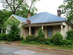 | Alfred and Jane Ables House | 0.2 miles | 2002 |
 | Pasaquan | 4.4 miles | 2008 |
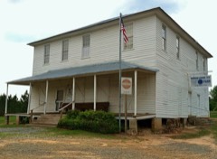 | Old Marion County Courthouse | 6.1 miles | 1980 |
| National Archives record | The nomination case file for reference 99000899 in Record Group 79. |
| Marion County | All 7 listed properties in this county. |