 Block
From the record
7 National Register listings published here.
Sources: the National Register database, National Park Service
24 topographic sheets cover 19 settlements here, and 7 properties are on the National Register of Historic Places.
7 National Register listings published here.
Sources: the National Register database, National Park Service
Every property in this county listed on the National Register of Historic Places, with the year it was listed and the federal nomination document.
| Photograph | Property | Type | Listed | Reference |
|---|---|---|---|---|
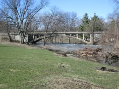 | Cherry Street Bridge | structure | 1998 | 98000753 |
| Coldwater Church of the Brethren | building | 1979 | 79000883 | |
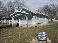 | Charles H. & Theresa H. McBride Bungalow | building | 2011 | 10001205 |
| Netcott-Pfeiffer House | building | 2007 | 07000347 | |
| Renke and Wubke Renken House | building | 2014 | 13001075 | |
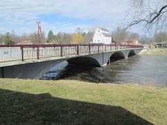 | Shell Rock Bridge | structure | 1999 | 99000307 |
| Charles Wolf House | building | 1979 | 79000884 |
Every wildfire the federal occurrence database records inside this county: 24 of them, burning about 319 acres. None started naturally and 5 were recorded as arson. Each settlement page carries the fires within five miles of it.
| Reported cause | Fires |
|---|---|
| Missing data/not specified/undetermined | 8 |
| Debris and open burning | 7 |
| Arson/incendiarism | 5 |
| Equipment and vehicle use | 4 |
The five largest, by the area the report gives. One of them was set deliberately.
| Date | Cause | Size | Reported by | Name on the report |
|---|---|---|---|---|
| 11 April 2014 | Debris and open burning | 150 acres | Iowa Department of Natural Resources | not named |
| 17 October 2020 | Equipment and vehicle use | 40 acres | Iowa Department of Natural Resources | not named |
| 20 March 2015 | Arson/incendiarism | 20 acres | Iowa Department of Natural Resources | not named |
| 1 December 2006 | Missing data/not specified/undetermined | 15 acres | Iowa Department of Natural Resources | not named |
| 25 April 2013 | Debris and open burning | 10 acres | Iowa Department of Natural Resources | not named |
| 20 March 2015 | Missing data/not specified/undetermined | 10 acres | Iowa Department of Natural Resources | not named |
| 1 April 2010 | Missing data/not specified/undetermined | 10 acres | Iowa Department of Natural Resources | 53265 140TH ST., IOWA |
| 17 October 2020 | Equipment and vehicle use | 8.0 acres | Iowa Department of Natural Resources | not named |
Every settlement page carries the fires within five miles of it - see the settlement index below.
The NOAA Storm Events Database holds 509 reports for this county, causing 11 deaths, 58 injuries and about $94,746,530 in recorded property damage. Each settlement page carries the reports that name it.
| Kind of event | Reports |
|---|---|
| Hail | 172 |
| Thunderstorm Wind | 135 |
| Flood | 67 |
| Heavy Rain | 66 |
| Tornado | 31 |
| Flash Flood | 28 |
| Funnel Cloud | 7 |
| Lightning | 3 |
The most serious of them, by death, then injury, then recorded damage. The accounts are quoted exactly as the forecast office filed them.
| When | Event | Place named | Harm | What the report says |
|---|---|---|---|---|
| May 2008 | Tornado (EF5) | Aplington | 9 killed, 50 hurt, $75,000,000 | First EF5 tornado in Iowa since 13 June 1976. Nine deaths and 50 injuries occurred in Butler County. Tornado moved out of Butler County and continued in Black Hawk County. |
| May 2013 | Flood | Parkersburg | 1 killed, $500,000 | Beaver Creek out of its banks and flooding about a mile long section of Iowa Highway 57 west of Parkersburg. Iowa DOT has already closed that section of the highway with water reaching several houses. |
| May 2017 | Thunderstorm Wind | Parkersburg | 1 killed, $60,000 | Coop observer reported very high winds estimated at over 70 mph. Power reported out in Parkersburg, semi overturned on Highway 57 resulting in one fatality, and numerous tree limbs down on roads. A 3 foot diameter tree also downed in Parkersburg. |
| September 1961 | Tornado (F4) | not stated | 7 hurt, $2,500,000 | no account filed |
| May 2017 | Thunderstorm Wind | Aplington | 1 hurt, $100,000 | A machine shed was blown down on top of a person, who was extricated and taken to the hospital. A building in Greene collapsed and caused a gas leak. Widespread tree damage and numerous trees down, power lines down and building damage throughout the western half of the county. |
| June 1984 | Tornado (F1) | not stated | $2,500,000 | no account filed |
| June 2013 | Flood | Parkersburg | $1,000,000 | About 1500 to 2000 feet of railroad tracks were washed out near Parkersburg. Several houses on the west side of town have at least a foot of water in them. |
| May 2013 | Thunderstorm Wind | Greene | $600,000 | Large steel outbuilding was destroyed. Eighteen houses sustained structural damage. |
| June 2013 | Flash Flood | Eleanor | $500,000 | Thunderstorms produced 3.5 to 4 inches of rain in a short time. Roads covered in Aplington in the area of Highway 57 and 6th Ave. |
| June 2013 | Flash Flood | Austinville | $500,000 | Highway 57 closed both east and west of Aplington due to water. Numerous County roads including black topped roads are closed in the Aplington area and to the south and west of Aplington. |
| July 2011 | Thunderstorm Wind | Aplington | $500,000 | House roof was partially ripped off and 6 outbuildings were destroyed with significant tree damage. |
| June 2013 | Flood | New Hartford | $500,000 | no account filed |
| July 1999 | Flash Flood | Clarksville | $500,000 | no account filed |
| June 2014 | Tornado (EF0) | Allison Muni Arpt | $400,000 | This second tornado near Clarksville formed just south of tornado #1 as it was in the latter stages of its life. It heavily damaged multiple shelter belts and destroyed several outbuildings on a farmstead before dissipating. It caused EF1 damage to both the shelter belts and the farmstead. |
| July 1999 | Flash Flood | Parkersburg | $350,000 | no account filed |
| July 2021 | Tornado (EF1) | Shell Rock | $300,000 | Tornado developed southwest of Shell Rock and moved along 250th Street. The tornado impacted several farmsteads along 250th producing EF1 damage to buildings and trees at many of the locations. The tornado was also quite wide with the the max width extending over 600 yards. The tornado continued into Bremer county. |
| September 2016 | Flood | Clarksville | $300,000 | Emergency Manager reported levee on the west side of Clarksville along the Shell Rock river failed and the southwest side of town is flooding. Residents being evacuated. |
| June 2013 | Flash Flood | Dumont | $300,000 | Highway 3 covered by running water in various places between Hansell and Dumont in Butler County. Streams out of their banks and fields full of water. |
| June 2008 | Flood | New Hartford | $300,000 | no account filed |
| June 2014 | Thunderstorm Wind | Clarksville | $250,000 | Numerous trees and power lines down throughout town. Worst trees damage was on the southern and western side of town. Most trees in this region sustained limb damage or were snapped. Winds lasted six minutes based on spotter account. The falling trees damaged several houses, buildings, and power lines. |
| May 2013 | Flash Flood | New Hartford | $250,000 | Terrace Ave, a gravel road levee, is failing and water is flowing into New Hartford. |
| June 2010 | Flood | Dumont | $250,000 | From Highway 3 north to the south half of town is flooding and evacuations are taking place. West Fork of the Cedar River flooding this area. Highway 3 is closed east and west of Dumont. |
| June 2013 | Flood | Packard | $250,000 | no account filed |
| May 2013 | Flood | New Hartford | $250,000 | no account filed |
| June 2008 | Flood | Packard | $250,000 | no account filed |
| May 2018 | Flood | Shell Rock | $200,000 | The Shell Rock River at Shell Rock crested at 13.66 feet on 5 May 2018 at 20:15 UTC. |
| September 2016 | Flash Flood | Greene | $200,000 | Emergency Manager reported many roads closed throughout the northern fourth of Butler county. The Shell Rock river reported beginning to leave its banks and moving toward businesses in downtown Greene. Sandbagging ongoing in Green and Clarksville. |
| September 2016 | Flash Flood | Greene | $200,000 | Emergency manager reported multiple homes in Greene now being impacted by floodwaters from the rapidly rising Shell Rock river. Also estimated that the river is near the level it reached in 2008. |
| June 2014 | Tornado (EF1) | Allison Muni Arpt | $200,000 | This is the first of three tornadoes that formed around the Clarksville area. This narrow tornado formed north of Allison and tracked just south of due east, hitting several farmsteads and causing primarily tree damage. The tornado strengthened to an EF1 as it passed over a farmstead towards the end of its track, completely destroying a barn and heavily damaging a shelter belt. The tornado dissipated shortly thereafter as the second tornado passed just to the south. |
| June 2014 | Tornado (EF1) | Clarksville | $200,000 | This short-lived tornado formed east of Clarksville and caused damage to multiple shelter belts. It strengthened to an EF1 as it passed over a house and removed part of its roof. The tornado damaged another house a mile further east before dissipating shortly thereafter. |
| June 1997 | Flash Flood | Parkersburg | $200,000 | no account filed |
| June 2016 | Lightning | Greene | $150,000 | Emergency Manager reported a house fire due to a lightning strike. |
| May 2013 | Thunderstorm Wind | Wilmar | $150,000 | Small car and tractor blown off highway. Many large trees down on houses. Numerous trees up to 4 feet in diameter and power lines down in the city of Greene with the entire city without power. |
| May 2013 | Thunderstorm Wind | Aredale | $150,000 | Significant roof damage to a containment building. |
| May 1999 | Flash Flood | New Hartford | $150,000 | no account filed |
| June 2018 | Flood | Shell Rock | $100,000 | The Shell Rock River at Shell Rock crested at 15.45 feet on 11 June 2018 at 11:15 UTC. |
| June 2018 | Flood | Greene | $100,000 | Flooding continued along the Shell Rock River with all campgrounds near Clarksville closed including Henry Woods State Park and Shell Rock Park due to flooding. A few businesses along the river were impacted as well. |
| June 2018 | Flood | Greene | $100,000 | Flooding is occurring along Flood Creek with several roads inundated. |
| September 2018 | Flood | Shell Rock | $100,000 | The Shell Rock River at Shell Rock crested at 14.49 feet on 6 September 2018 at 1415 UTC. |
| September 2018 | Flood | Aredale | $100,000 | Emergency manager reported several road closures due to water over the roadways across the county with the worst area near Dumont. |
| September 2018 | Flood | Shell Rock | $100,000 | The Shell Rock River at Shell Rock crested at 15.44 feet on 22 September 2018 at 1715 UTC. |
| June 2008 | Flood | Aplington | $100,000 | A failure of a levee in New Hartford on U.S. Highay 14 north of Parkersburg and Highway 57 west is closed at Aplington. Highway 57 east was closed at New Hartford. |
| May 2004 | Flash Flood | Countywide | $100,000 | no account filed |
| June 1997 | Tornado (F1) | Dumont | $100,000 | no account filed |
| June 2014 | Thunderstorm Wind | Aredale | $80,000 | Two empty grain bins ripped from foundation and thrown 75 yards to the SE. Swath of area 4 miles south and several miles east of this point also had tree limb damage. |
| December 2021 | Thunderstorm Wind | Bristow | $75,000 | Emergency manager reported one outbuilding leveled and another missing the north wall. Time estimated from radar. |
| June 2012 | Thunderstorm Wind | Allison Muni Arpt | $75,000 | A barn was blown down by strong winds. Branches of up to a foot in diameter were blown down as well. |
| September 2001 | Tornado (F1) | Shell Rock | $75,000 | Tornado hit grain bin and blew downwind 1/4 mile. Shed was destroyed on a farm south of Shell Rock. Tornado moved into Bremer County. |
| June 2002 | Hail | Parkersburg | $75,000 | no account filed |
| June 2002 | Flash Flood | Countywide | $75,000 | no account filed |
| December 2001 | Thunderstorm Wind | Allison | $75,000 | no account filed |
| May 1998 | Thunderstorm Wind | Aredale | $75,000 | no account filed |
| June 2014 | Thunderstorm Wind | Clarksville | $70,000 | Swath of RFD winds south of the two tornadoes. Large tree snapped on farmstead. Empty grain bin rolled 75 yards to the ENE. Many tree limbs downed for a mile north and several miles E and W of this point. |
| May 2024 | Thunderstorm Wind | Greene | $50,000 | Emergency manager reported trees blown onto a house west of Greene near the intersection of 110th st and Keystone Ave. Time estimated from radar. |
| March 2019 | Flood | Austinville | $50,000 | Iowa DOT reported Iowa 57 from near Austinville to west of Parkersburg closed due to flooding. |
| September 2018 | Flood | Dumont | $50,000 | Iowa DOT and local law enforcement reported flooding along Highway 3 in both directions in Dumont. The road was closed overnight and the flooding ended as the level of the Shell Rock River and Hargrave Creek near Dumont both started to fall. |
| September 2018 | Flood | Greene | $50,000 | Emergency management reported multiple road closures due to standing or running water over the roadways. Creeks across much of the county were overwhelmed with flooded fields as well. |
| September 2018 | Flash Flood | Packard | $50,000 | A trained spotter reported that multiple gravel roads west of Plainfield have water flowing over them, as much as 2-3 feet deep. |
| June 2016 | Flood | Greene | $50,000 | The Emergency Manager reported the Shell Rock River was out of its banks in the town of Greene, and was entering a campgroud and near a few business in town. Campers were evacuated from the campground. The park was flooded, and the water did not enter any businesses. |
| September 2016 | Flood | Shell Rock | $50,000 | Iowa DOT and local law enforcement have closed Highway 3 between County Road T55 near Clarksville and US 218 near Shell Rock due to flooding of the Shell Rock River. |
The Survey's mineral resources record lists 43 workings inside this county. 9 still produce and 34 are closed or unrecorded. Each settlement page carries the workings within five miles of it.
| Commodity | Workings |
|---|---|
| Sand and Gravel, Construction | 23 |
| Stone, Crushed/Broken | 20 |
The least common of them first, because a county's hundredth gravel pit says nothing its first ten did not.
| Where | Site | Commodity | Status | Recorded |
|---|---|---|---|---|
| Bruns Quarry | Stone, Crushed/Broken | Past Producer | ||
| Carolus Quarry | Stone, Crushed/Broken | Past Producer | ||
| Engle-Clarksville Quarry | Stone, Crushed/Broken | Past Producer | ||
| Freeseman Quarry | Stone, Crushed/Broken | Producer | ||
| Green Limestone Co Shop | Stone, Crushed/Broken | Producer | ||
| Lubben Quarry | Stone, Crushed/Broken | Producer | ||
| Neymeyer Quarry | Stone, Crushed/Broken | Producer | ||
| Oltmann Quarry | Stone, Crushed/Broken | Producer | ||
| Park Quarry | Stone, Crushed/Broken | Past Producer | ||
| Rattlesnake Quarry | Stone, Crushed/Broken | Past Producer | ||
| Shell Rock Quarry | Stone, Crushed/Broken | Past Producer | ||
| Steer Quarry | Stone, Crushed/Broken | Past Producer | ||
| Stubbe Quarry | Stone, Crushed/Broken | Past Producer | ||
| Unknown | Stone, Crushed/Broken | Past Producer | ||
| Unknown | Stone, Crushed/Broken | Past Producer | ||
| Unknown | Stone, Crushed/Broken | Past Producer | ||
| Unknown | Stone, Crushed/Broken | Past Producer | ||
| Unknown | Stone, Crushed/Broken | Past Producer | ||
| Witte Quarry | Stone, Crushed/Broken | Producer | ||
| Wpa Quarry | Stone, Crushed/Broken | Past Producer | ||
| Austinville Pit | Sand and Gravel, Construction | Unknown | ||
| Beucholtz Pit | Sand and Gravel, Construction | Past Producer | ||
| Clarksville Pit | Sand and Gravel, Construction | Past Producer | ||
| Greene Pit | Sand and Gravel, Construction | Past Producer | ||
| Hurd Pit | Sand and Gravel, Construction | Producer | ||
| Knocks Sand and Gravel | Sand and Gravel, Construction | Producer | ||
| Kreymeyer Pit | Sand and Gravel, Construction | Past Producer | ||
| Limburg Pit | Sand and Gravel, Construction | Past Producer | ||
| Schnee Pit | Sand and Gravel, Construction | Unknown | ||
| Shell Rock Pit | Sand and Gravel, Construction | Producer | ||
| Stevenson Pit | Sand and Gravel, Construction | Past Producer | ||
| Unknown | Sand and Gravel, Construction | Past Producer | ||
| Unknown | Sand and Gravel, Construction | Unknown | ||
| Unknown | Sand and Gravel, Construction | Past Producer | ||
| Unknown | Sand and Gravel, Construction | Unknown | ||
| Unknown | Sand and Gravel, Construction | Past Producer | ||
| Unknown | Sand and Gravel, Construction | Past Producer | ||
| Unknown | Sand and Gravel, Construction | Past Producer | ||
| Unknown | Sand and Gravel, Construction | Past Producer | ||
| Unknown | Sand and Gravel, Construction | Unknown | ||
| Unknown | Sand and Gravel, Construction | Past Producer | ||
| Unknown | Sand and Gravel, Construction | Unknown | ||
| Unknown | Sand and Gravel, Construction | Unknown |
Named settlements recorded in the Geographic Names Information System, each with the topographic sheets covering it. Villages, hamlets and abandoned places alike. Each is shown with the nearest named watercourse or landform and the survey quadrangle it falls on.
Washington township · 50608 · On North Beaver Creek · Aplington quadrangle
9 sheets, 1954 to 1984
Jefferson township · 50665 · On Freddeke Creek · Coster quadrangle
9 sheets, 1954 to 1984
West Point township · 50602 · On Dailey Creek · Allison quadrangle
9 sheets, 1954 to 1984
Shell Rock township · 50670 · On Curry Creek · Shell Rock quadrangle
9 sheets, 1954 to 1984