 Block
From the record
14 National Register listings published here.
Sources: the National Register database, National Park Service
38 topographic sheets cover 27 settlements here, and 14 properties are on the National Register of Historic Places.
14 National Register listings published here.
Sources: the National Register database, National Park Service
Every property in this county listed on the National Register of Historic Places, with the year it was listed and the federal nomination document.
| Photograph | Property | Type | Listed | Reference |
|---|---|---|---|---|
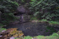 | Backbone State Park Historic District | district | 1991 | 91001842 |
| Backbone State Park, Cabin-Bathing Area (Area A) | district | 1990 | 90001681 | |
| Backbone State Park, Picnicking, Hiking & Camping Area (Area B) | district | 1990 | 90001682 | |
| Backbone State Park, Richmond Springs (Area C) | district | 1990 | 90001683 | |
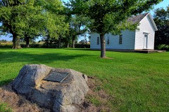 | Bay Settlement Church and Monument | site | 1977 | 77000506 |
| Coffin's Grove Stagecoach House | building | 1975 | 75000681 | |
 | Delaware County Courthouse | building | 1981 | 81000234 |
 | J. J. Hoag House | building | 1976 | 76000760 |
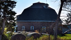 | Kirkpatrick, Robert Round Barn | building | 2005 | 05000252 |
 | Lincoln Elementary School | building | 2002 | 02001243 |
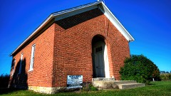 | McGee School | building | 1999 | 99001251 |
| Old Lenox College | district | 1974 | 74000781 | |
 | Saints Peter and Paul Church | building | 1995 | 94001589 |
| Ruth Suckow House | building | 1977 | 77000507 |
Every wildfire the federal occurrence database records inside this county: 48 of them, burning about 218 acres. None started naturally and none was recorded as arson. Each settlement page carries the fires within five miles of it.
| Reported cause | Fires |
|---|---|
| Missing data/not specified/undetermined | 32 |
| Debris and open burning | 14 |
| Smoking | 1 |
| Equipment and vehicle use | 1 |
The five largest, by the area the report gives. None of them was recorded as arson.
| Date | Cause | Size | Reported by | Name on the report |
|---|---|---|---|---|
| 21 March 2009 | Missing data/not specified/undetermined | 25 acres | Iowa Department of Natural Resources | not named |
| 1 April 2015 | Debris and open burning | 25 acres | Iowa Department of Natural Resources | not named |
| 28 March 2015 | Debris and open burning | 20 acres | Iowa Department of Natural Resources | not named |
| 7 October 2011 | Missing data/not specified/undetermined | 15 acres | Iowa Department of Natural Resources | 1551 197TH ST., IA |
| 29 March 2010 | Missing data/not specified/undetermined | 15 acres | Iowa Department of Natural Resources | 2539 155TH STREET, EARLVILLE, IA, IOWA |
| 9 April 2006 | Missing data/not specified/undetermined | 15 acres | Iowa Department of Natural Resources | not named |
| 11 April 2009 | Missing data/not specified/undetermined | 10 acres | Iowa Department of Natural Resources | not named |
| 26 February 2006 | Missing data/not specified/undetermined | 7.0 acres | Iowa Department of Natural Resources | not named |
Every settlement page carries the fires within five miles of it - see the settlement index below.
The NOAA Storm Events Database holds 465 reports for this county, causing no deaths, 22 injuries and about $96,131,580 in recorded property damage. Each settlement page carries the reports that name it.
| Kind of event | Reports |
|---|---|
| Thunderstorm Wind | 219 |
| Hail | 152 |
| Tornado | 40 |
| Flash Flood | 32 |
| Flood | 8 |
| Heavy Rain | 7 |
| Lightning | 4 |
| Funnel Cloud | 3 |
The most serious of them, by death, then injury, then recorded damage. The accounts are quoted exactly as the forecast office filed them.
| When | Event | Place named | Harm | What the report says |
|---|---|---|---|---|
| August 1974 | Tornado (F4) | not stated | 12 hurt, $2,500,000 | no account filed |
| August 1986 | Tornado (F1) | not stated | 3 hurt, $25,000 | no account filed |
| July 1971 | Tornado (F3) | not stated | 2 hurt, $2,500,000 | no account filed |
| May 1964 | Tornado (F2) | not stated | 2 hurt, $250,000 | no account filed |
| May 2006 | Lightning | Petersburg | 2 hurt | Two men ages 42 and 29 were assembling a swing set in a backyard. Both noticed lightning in the distance and decided to go inside. Lightning struck a pickup truck both were leaning against and threw them several feet. After an overnight hospitalization for observation, both were released. |
| March 1991 | Tornado (F2) | not stated | 1 hurt, $250,000 | no account filed |
| July 2010 | Flash Flood | Manchester Arpt | $25,000,000 | Record flooding on the Maquoketa River resulted in the failure of the earthen berm on the south side of the Lake Delhi/Hartwick Lake dam during the late morning and afternoon of July 24. The dam failure resulted in flash flooding of residences along the Maquoketa River immediately downstream of the dam, including portions of Hopkinton. In addition, the dam failure emptied out the 9 mile stretch of the Maquoketa River that constituted Lake Delhi/Hartwick Lake.||In Hopkinton, a few homes, several garages, outbuildings, parks and roads flooded. ||By the time the flood waters reached Monticello, the flood wave from the dam failure had largely been absorbed in the larger crest due to the ongoing record flooding of the Maquoketa River.||Please see the Storm Data narrative for the record flooding on the Maquoketa River for details on the damage due to the flooded Maquoketa River, including the homes at Lake Delhi. |
| July 2010 | Flood | Backbone State Park | $25,000,000 | After about 10 inches of rain fell in the upper Maquoketa River basin, the river surged to record stage levels. ||The initial impact off the surging river levels was seen in Manchester, where portions of the business district as well as numerous homes were affected by flood waters. With water reaching near the rooftops of at least one business, West Main Street was particularly hard-hit, with 2 fast food restaurants, a car dealership, a pharmacy, and several other businesses succombing to the flood waters. Numerous basements filled with water, and there were reports of several basement walls that had collapsed. One man experienced a near-miss when a sinkhole developed in a parking lot and the skidloader he was driving collapsed into the raging Maquoketa River beneath the parking lot. ||County conservationists estimated that about 2000 acres of crops and another 2000 acres of pasture were covered by the flooded Maquoketa River, their yields almost entirely lost. ||Numerous properties were damaged along the river, including about 500 homes bordering Lake Delhi. Four to five feet of water filled some homes and businesses, including the Lake Delhi marina office. ||On Saturday July 24th the Lake Delhi dam failed, allowing the water to drain rapidly from the lake and flood waters to recede from the Lake Delhi properties. Please see the Storm Data entry for the Delaware County flash flood on 7/24 for a description of the Lake Delhi dam failure and its direct impacts. |
| March 1990 | Tornado (F4) | not stated | $25,000,000 | no account filed |
| June 2008 | Flood | Backbone State Park | $4,200,000 | no account filed |
| May 2000 | Hail | Manchester | $4,000,000 | no account filed |
| May 2003 | Thunderstorm Wind | Manchester | $2,000,000 | Also reported by law enforcement |
| April 2009 | Tornado (EF1) | Ryan | $500,000 | Continued from Linn County. An EF1 tornado with estimated wind speeds of up to 100 mph touched down near Lafayette, IA around 452 pm and proceeded to track northeast crossing the Linn-Delaware County line around 510 pm, finally lifting just north of Buck Creek, IA around 530 pm. Several farms sustained structural and equipment damage, trees were uprooted or snapped off, some camping trailers were destroyed, and several power lines were blown down. |
| October 2007 | Flash Flood | Manchester | $500,000 | There were several reports of rainfall of 6 inches in the city of Manchester, with a trained spotter measuring 3 inches in one hour. Considerable basement and street flooding occurred, and there was some damage to gravel roads in the surrounding rural areas. Water was knee deep in some parts of the city, and many streets were closed. About 150 homes in the area had basement flooding or damage to foundations. The administration building at Manchester's school bus garage was flooded with two feet of water on the main floor. In only about 3 hours, the city received twice as much rain as it usually gets in the entire month of October. |
| April 1994 | Thunderstorm Wind | Ryan | $500,000 | no account filed |
| June 2009 | Thunderstorm Wind | Ryan | $250,000 | Wind gusts estimated to be 75 mph destroyed some large grain bins at the Ryan, IA COOP around 803 am June 19. In addition, several trees were blown down in town and roof damage was widespread. This report was relayed by the Emergency Manager. |
| July 2009 | Hail | Oneida | $250,000 | Hail the size of a golf ball fell in about 2 miles north of Delaware, IA around 228 pm July 24. Several houses near Highway 38 just north of town sustained broken windows and siding damage due to the hail. |
| June 1990 | Tornado (F2) | not stated | $250,000 | no account filed |
| November 1988 | Tornado (F2) | not stated | $250,000 | no account filed |
| June 1969 | Tornado (F2) | not stated | $250,000 | no account filed |
| November 1960 | Tornado (F2) | not stated | $250,000 | no account filed |
| March 2007 | Tornado (EF1) | Delaware | $162,000 | This tornado began 5.4 miles north of Delaware, in Delaware county, at about 429 pm CST, and crossed into Clayton county 6 miles east of Edgewood at approximately 437 pm CST. The tornado was rated EF1 (NWS storm survey team), moved north-northeast at 50 mph, and had a total path length of 10 miles and was 200 yards wide. The tornado struck eight farmsteads in Delaware county, producing mostly minor damage to outbuildings and trees. However, at a farm southeast of Greeley, EF1 damage occurred with winds estimated at 81 mph. A dairy barn collapsed, trapping two people that were milking cows under the debris. They were rescued unharmed, but 24 cows were killed. A two-car garage was completely blown off its foundation, but the house next to it had little damage. An eyewitness just southwest of this farmstead reported seeing rotation in the clouds as it descended and struck the dairy barn. Near the Delaware-Clayton county line, a narrow swath of considerable tree damage was noted, with debris carried up a hillside and spread across a road. Path length in Delaware county was more than 7 miles, and damage was estimated at $162,000.| |
| September 2016 | Flood | Dundee | $150,000 | Heavy rainfall of 4 to over 10 inches over significant areas from 21 to 23 September in extreme North Central and Northeast Iowa moved downstream causing the Maquoketa River to rise above major flood stage levels. ||Manchester rose above its major flood stage level of 20.0 feet on September 23rd, 2016 at approximately 12 PM CST. It crested around 20.3 feet at approximately 3 PM CST on September 23rd, 2016. It fell below major flood stage on September 23rd around 4 PM CST. |
| June 2014 | Tornado (EF1) | Dundee | $100,000 | A tornado formed 4 miles south of Lamont, IA in Buchanan County, tracked about 1 mile to the northeast before crossing into Delaware County. In Delaware County the tornado continued for about 13 miles to the northeast to Edgewood, IA. ||This entry is for the Delaware County portion of the tornado track (second and final segment).||Most of the damage was south and east of Dundee into south Edgewood. Several grain bins collapsed or were destroyed. Two old hog confinements were seriously damaged along with an aluminum roof being torn off. Numerous trees were snapped along the path. |
| July 2010 | Flood | Manchester | $100,000 | Heavy rains on July 22 and 23 caused the Maquoketa River to rise 3 feet in about 2 hours during the late afternoon and evening of July 23. Some docks and decks were damaged along the river. |
| June 2009 | Thunderstorm Wind | Ryan | $100,000 | Wind gusts estimated to be 75 mph blew down several power lines south of Highway 20 across Delaware County around 808 am June 19. |
| June 2009 | Thunderstorm Wind | Earlville | $100,000 | Wind gusts estimated to be 75 mph blew some trees down, blew some windows in, and caused some roof damage in Earlville, IA around 815 am June 19. |
| June 2009 | Thunderstorm Wind | Delhi | $100,000 | Wind gusts estimated to be 70 mph blew numerous tree limbs down in Delhi, IA around 809 am June 19. In addition, the windows of one house were blown out and some boats sunk in Lake Delhi. A power outage was also observed in town. |
| July 2009 | Hail | Edgewood | $100,000 | Hail the size of a golf ball fell in Edgewood, IA around 221 pm July 24. Some residences had windows broken due to the hail. |
| May 2008 | Tornado (EF1) | Dundee | $100,000 | Tornado moved from Buchanan County into Delaware County. It was on the ground for about 11 miles before it lifted near Oneida. Some farmsteads, trees, and power lines were damaged. |
| May 2008 | Tornado (EF1) | Petersburg | $100,000 | A tornado touched down southwest of Petersburg and moved east for approximately 7 miles to the Delaware-Dubuque county line. Along its path, trees, power poles, and numerous farm outbuildings were damaged. It continued to track into Dubuque County. |
| May 2008 | Flash Flood | Backbone State Park | $100,000 | Heavy rains of 3 to 7 inches caused flash flooding in the vicinity of Backbone State Park, IA during the late evening hours of May 25th and early morning of May 26th. The flash flooding overwhelmed the four miles of roads and bridges throughout the park leaving holes three feet deep. Several trees fell due to the saturated soil conditions. |
| July 2003 | Thunderstorm Wind | Hopkinton | $100,000 | Phone & power lines down |
| August 2004 | Tornado (F1) | Hopkinton | $75,000 | Rated high F1 |
| July 1995 | Thunderstorm Wind | Manchester | $75,000 | no account filed |
| June 2014 | Tornado (EF1) | Spencers Grove | $50,000 | Spotters observed a tornado southeast of the town of Delaware in Delaware County. The tornado left a damage path to the northeast, ending near Colesburg, IA. Damage was primarily to power poles, trees, and farm outbuildings. The tornado damage was rated EF1 and the wind was estimated at 105 mph. |
| July 2013 | Flash Flood | Backbone State Park | $50,000 | Heavy rains of 3 to 5 inches fell across parts of northeast Delaware County during the evening of July 8 resulting in some flash flooding. Some roads were washed out. |
| June 2009 | Thunderstorm Wind | Delhi | $50,000 | Wind gusts estimated to be 70 mph blew a tree down onto a house in Delhi, IA around 809 am June 19. |
| July 2009 | Thunderstorm Wind | Edgewood | $50,000 | Wind gusts estimated to be 75 mph blew a roof off a building in Edgewood, IA around 700 pm July 24. |
| July 2009 | Thunderstorm Wind | Earlville | $50,000 | Wind gusts estimated to be 70 mph blew a tree down near the intersection of Stow Street and Prospect Street in Earlville, IA around 240 pm July 24. In addition, a tree fell onto the Orcutt residence. |
| May 2004 | Flash Flood | Countywide | $50,000 | Many roads impassible with or damaged by water |
| April 1994 | Thunderstorm Wind | New Vienna | $50,000 | no account filed |
| April 1994 | Thunderstorm Wind | Manchester | $50,000 | no account filed |
| April 1994 | Hail | Earlville | $50,000 | no account filed |
| August 1998 | Thunderstorm Wind | Sand Spg | $35,000 | no account filed |
| September 2013 | Thunderstorm Wind | Delaware | $25,000 | Broadcast Media reported a large sign was blown down damaging 3 cars. Time of the event was estimated from radar. |
| April 2010 | Thunderstorm Wind | Robinson | $25,000 | Wind gusts estimated to be 65 mph damaged or destroyed an unoccupied mobile home about 5 miles southwest of Ryan, IA around 1007 pm April 5. |
| June 2009 | Thunderstorm Wind | Ryan | $25,000 | Wind gusts estimated to be 75 mph ripped the soffit from a house just east of Ryan, IA around 808 am June 19. |
| July 2009 | Hail | Oneida | $25,000 | Large hail estimated to be golf ball-size fell about 1 mile west of Oneida, IA at the Kleusner farm around 225 pm July 24. The siding of the residence, garage, and other buildings were heavily damaged. The wind driven large hail also broke several windows of both the house and vehicles. |
| June 2008 | Flash Flood | Dundee | $25,000 | Heavy rains resulted in some flash flooding of numerous county roads in the vicinity of Dundee, IA during the evening of June 8. The roads were either washed out or covered with flood waters. Additional county roads across Delaware County were also experiencing flash flooding. |
| June 2005 | Thunderstorm Wind | Petersburg | $25,000 | A machine shed and two barns were destroyed at the Theisen (pronoused tyson) farm northwest of New Vienna on 160th Street. Additionally a large tree was downed that just missed the house. |
| May 1991 | Tornado (F1) | not stated | $25,000 | no account filed |
| May 1988 | Tornado (F0) | not stated | $25,000 | no account filed |
| May 1988 | Tornado (F0) | not stated | $25,000 | no account filed |
| July 2008 | Lightning | Manchester | $15,000 | Lightning struck the Delaware County Courthouse at 418 am July 21 damaging the roof, security camera system, elevator, telephone system, and wireless connection to the engineer's office. |
| May 2004 | Thunderstorm Wind | Dundee | $15,000 | Roof off a hog building with slight damage to a machine shed and the farm house |
| June 2005 | Thunderstorm Wind | Ryan | $12,000 | Barn down |
| May 2017 | Thunderstorm Wind | Petersburg | $10,000 | A trained spotter reported several farm buildings damaged near Dyersville. |
| April 2010 | Thunderstorm Wind | Buck Creek | $10,000 | Wind gusts estimated to be 65 mph damaged the roof of a barn about 3 miles southwest of Hopkinton, IA at 1022 pm April 5. |
| July 2006 | Lightning | Manchester | $10,000 | Some time between 1045 and 1115 CST lightning struck one of the West Delaware School District buildings and destroyed the phone system. |
The Survey's mineral resources record lists 72 workings inside this county. 14 still produce and 58 are closed or unrecorded. Each settlement page carries the workings within five miles of it.
| Commodity | Workings |
|---|---|
| Stone, Crushed/Broken | 45 |
| Sand and Gravel, Construction | 22 |
| Clay | 3 |
| Zinc | 1 |
| Sand and Gravel, Construction, Stone, Crushed/Broken | 1 |
The least common of them first, because a county's hundredth gravel pit says nothing its first ten did not.
| Where | Site | Commodity | Status | Recorded |
|---|---|---|---|---|
| George Huber Farm | Zinc | Past Producer | Sphalerite | |
| Logan Quarry | Sand and Gravel, Construction, Stone, Crushed/Broken | Producer | ||
| Mattox Brickyard | Clay | Past Producer | ||
| Unknown | Clay | Past Producer | ||
| Williamson and Stead Brickyard | Clay | Past Producer | ||
| Arnold Pit | Sand and Gravel, Construction | Past Producer | ||
| Ferguson Pit | Sand and Gravel, Construction | Past Producer | ||
| Hard Scrabble Pit | Sand and Gravel, Construction | Past Producer | ||
| Hoth Pit | Sand and Gravel, Construction | Past Producer | ||
| Ready Mix Sand Pit | Sand and Gravel, Construction | Producer | ||
| Tegeler Lake Sand Pit | Sand and Gravel, Construction | Producer | ||
| Unknown | Sand and Gravel, Construction | Past Producer | ||
| Unknown | Sand and Gravel, Construction | Past Producer | ||
| Unknown | Sand and Gravel, Construction | Past Producer | ||
| Unknown | Sand and Gravel, Construction | Past Producer | ||
| Unknown | Sand and Gravel, Construction | Past Producer | ||
| Unknown | Sand and Gravel, Construction | Past Producer | ||
| Unknown | Sand and Gravel, Construction | Past Producer | ||
| Unknown | Sand and Gravel, Construction | Past Producer | ||
| Unknown | Sand and Gravel, Construction | Past Producer | ||
| Unknown | Sand and Gravel, Construction | Past Producer | ||
| Unknown | Sand and Gravel, Construction | Past Producer | ||
| Unknown | Sand and Gravel, Construction | Past Producer | ||
| Unknown | Sand and Gravel, Construction | Past Producer | ||
| Unknown | Sand and Gravel, Construction | Past Producer | ||
| Unknown | Sand and Gravel, Construction | Past Producer | ||
| Unknown | Sand and Gravel, Construction | Past Producer | ||
| Allen Quarry | Stone, Crushed/Broken | Past Producer | ||
| Bahl Quarry | Stone, Crushed/Broken | Past Producer | ||
| Buck Creek Quarry | Stone, Crushed/Broken | Past Producer | ||
| Colesburg Quarry | Stone, Crushed/Broken | Past Producer | ||
| Deutmeyer Quarry | Stone, Crushed/Broken | Producer | ||
| Dyersville No. 1 Quarry | Stone, Crushed/Broken | Producer | ||
| Edgewood Quarry | Stone, Crushed/Broken | Producer | ||
| Forrestville Quarry | Stone, Crushed/Broken | Past Producer | ||
| Goedkin Quarry | Stone, Crushed/Broken | Past Producer | ||
| Gogel Quarry | Stone, Crushed/Broken | Past Producer | ||
| Grieff Quarry | Stone, Crushed/Broken | Producer | ||
| Harris Quarry | Stone, Crushed/Broken | Past Producer | ||
| Kuhlman Quarry | Stone, Crushed/Broken | Producer | ||
| Lanning Quarry | Stone, Crushed/Broken | Past Producer | ||
| Loop Quarry | Stone, Crushed/Broken | Past Producer | ||
| Masonville Quarry | Stone, Crushed/Broken | Producer | ||
| Oneida Quarry | Stone, Crushed/Broken | Past Producer | ||
| Pins Quarry | Stone, Crushed/Broken | Producer | ||
| Schulte Quarry | Stone, Crushed/Broken | Past Producer | ||
| Sedgewick Quarry | Stone, Crushed/Broken | Producer | ||
| Thorpe Quarry | Stone, Crushed/Broken | Past Producer | ||
| Tibbott Quarry | Stone, Crushed/Broken | Producer | ||
| Truman House Quarry | Stone, Crushed/Broken | Past Producer | ||
| Unknown | Stone, Crushed/Broken | Past Producer | ||
| Unknown | Stone, Crushed/Broken | Past Producer | ||
| Unknown | Stone, Crushed/Broken | Past Producer | ||
| Unknown | Stone, Crushed/Broken | Past Producer | ||
| Unknown | Stone, Crushed/Broken | Past Producer | ||
| Unknown | Stone, Crushed/Broken | Past Producer | ||
| Unknown | Stone, Crushed/Broken | Past Producer | ||
| Unknown | Stone, Crushed/Broken | Past Producer | ||
| Unknown | Stone, Crushed/Broken | Past Producer | ||
| Unknown | Stone, Crushed/Broken | Past Producer | ||
| Unknown | Stone, Crushed/Broken | Past Producer | ||
| Unknown | Stone, Crushed/Broken | Past Producer | ||
| Unknown | Stone, Crushed/Broken | Past Producer | ||
| Unknown | Stone, Crushed/Broken | Past Producer | ||
| Unknown | Stone, Crushed/Broken | Past Producer | ||
| Unknown | Stone, Crushed/Broken | Past Producer | ||
| Unknown | Stone, Crushed/Broken | Past Producer | ||
| Unknown | Stone, Crushed/Broken | Past Producer | ||
| Walston-Masonville Quarry | Stone, Crushed/Broken | Past Producer | ||
| Weston Quarry | Stone, Crushed/Broken | Producer | ||
| White Quarry | Stone, Crushed/Broken | Producer | ||
| Wilcox Quarry | Stone, Crushed/Broken | Past Producer |
Named settlements recorded in the Geographic Names Information System, each with the topographic sheets covering it. Villages, hamlets and abandoned places alike. Each is shown with the nearest named watercourse or landform and the survey quadrangle it falls on.
Oneida township · 52041 · On Almoral Branch · Greeley quadrangle
12 sheets, 1902 to 1984
No longer a settlement
Union township · 52237 · On Lime Creek · Hopkinton West quadrangle
12 sheets, 1900 to 1984
Hazel Green township · 52223 · On Golden Branch · Ryan quadrangle
12 sheets, 1900 to 1984
South Fork township · 52237 · On Bell Creek · Hopkinton East quadrangle
12 sheets, 1900 to 1984
Delaware township · 52057 · On Coffins Creek · Manchester quadrangle
12 sheets, 1900 to 1984
Coffins Grove township · 50654 · On Prairie Creek · Masonville quadrangle
10 sheets, 1903 to 1984
North Fork township · 52078 · On Cooksley Creek · Dyersville West quadrangle
12 sheets, 1900 to 1984
The vanished settlements of Delaware County: the places named above that are no longer on the map.