 Block
From the record
12 National Register listings published here.
Sources: the National Register database, National Park Service
18 topographic sheets cover 21 settlements here, and 12 properties are on the National Register of Historic Places.
12 National Register listings published here.
Sources: the National Register database, National Park Service
Every property in this county listed on the National Register of Historic Places, with the year it was listed and the federal nomination document.
| Photograph | Property | Type | Listed | Reference |
|---|---|---|---|---|
 | Antlers Hotel | building | 2007 | 07000452 |
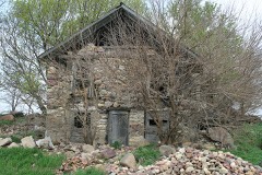 | Gerome Clark House | building | 1977 | 77000510 |
| Gull Point State Park, Area A | district | 1990 | 90001661 | |
| Gull Point State Park, Area B | district | 1990 | 90001662 | |
| Iowa Lakeside Laboratory Historic District | district | 1991 | 91001830 | |
| Mini-Wakan State Park Historic District | district | 2010 | 10000021 | |
| Okoboji Bridge | structure | 1998 | 98000789 | |
| Pikes Point State Park Shelter and Steps | district | 1990 | 90001675 | |
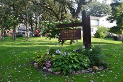 | Pillsbury Point State Park | structure | 1993 | 90001674 |
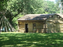 | Spirit Lake Massacre Log Cabin | building | 1973 | 73000724 |
 | Spirit Lake Public Library | building | 1980 | 80001448 |
| Trappers Bay State Park Picnic Shelter | building | 1990 | 90001676 |
Every wildfire the federal occurrence database records inside this county: 53 of them, burning about 1,374 acres. None started naturally and 2 were recorded as arson. Each settlement page carries the fires within five miles of it.
| Reported cause | Fires |
|---|---|
| Missing data/not specified/undetermined | 42 |
| Debris and open burning | 7 |
| Arson/incendiarism | 2 |
| Misuse of fire by a minor | 1 |
| Equipment and vehicle use | 1 |
The five largest, by the area the report gives. None of them was recorded as arson.
| Date | Cause | Size | Reported by | Name on the report |
|---|---|---|---|---|
| 1 April 2015 | Missing data/not specified/undetermined | 227 acres | Iowa Department of Natural Resources | not named |
| 25 December 2011 | Debris and open burning | 215 acres | Iowa Wetland Management District | WELCH LAKE FIRE |
| 19 April 2010 | Debris and open burning | 155 acres | Iowa Wetland Management District | GRAFF |
| 12 May 2011 | Missing data/not specified/undetermined | 100 acres | Iowa Department of Natural Resources | 1225 180TH ST., IA |
| 28 April 2013 | Missing data/not specified/undetermined | 80 acres | Iowa Wetland Management District | MOLLENDORP |
| 4 April 2009 | Missing data/not specified/undetermined | 80 acres | Iowa Department of Natural Resources | not named |
| 25 April 2014 | Missing data/not specified/undetermined | 69 acres | Iowa Department of Natural Resources | not named |
| 13 April 2009 | Missing data/not specified/undetermined | 60 acres | Iowa Department of Natural Resources | not named |
Every settlement page carries the fires within five miles of it - see the settlement index below.
The NOAA Storm Events Database holds 487 reports for this county, causing no deaths, 20 injuries and about $17,125,250 in recorded property damage. Each settlement page carries the reports that name it.
| Kind of event | Reports |
|---|---|
| Thunderstorm Wind | 176 |
| Hail | 174 |
| Flood | 77 |
| Flash Flood | 31 |
| Tornado | 28 |
| Lightning | 1 |
The most serious of them, by death, then injury, then recorded damage. The accounts are quoted exactly as the forecast office filed them.
| When | Event | Place named | Harm | What the report says |
|---|---|---|---|---|
| June 1968 | Tornado (F2) | not stated | 17 hurt, $2,500,000 | no account filed |
| June 2001 | Hail | Okoboji | 2 hurt, $100,000 | Large hail injured 2 people, and caused damage to vehicles and buildings. |
| June 1983 | Tornado (F1) | not stated | 1 hurt, $250,000 | no account filed |
| August 1990 | Tornado (F2) | not stated | $2,500,000 | no account filed |
| June 1981 | Tornado (F2) | not stated | $2,500,000 | no account filed |
| June 1981 | Tornado (F2) | not stated | $2,500,000 | no account filed |
| June 2024 | Flood | West Okoboji | $1,900,000 | Rainfall amounts across Dickinson County from June 20-22 ranged from 5 to 10 inches. Widespread overland flooding ensued with additional major to record flooding along the West Fork Little Sioux and Little Sioux Rivers. Lakeshore flooding was also observed across the Iowa Great Lakes. ||There were over 550 locations across the county where water crossed the road or there was severe gravel wash. Three bridges were also damaged and closed. Preliminary damage assessments estimate loss to public infrastructure to be 1.9 million dollars. ||County-wide, hundreds of homes reported flood damage with water or sewage in their basements. There were approximately 25 lakeshore homes with water onto the first floor, which required the temporary relocation of some residents. There were also flood damages to area businesses. Dozens of bank collapses were reported along East Okoboji, West Okoboji, Big Spirit, and Silver Lakes with nearly 3,000 ft of shoreline lost. West Okoboji Lake crested about six inches below the record set in 1993. ||The majority of overland flooding subsided by June 25, but river flooding continued through the end of the month. For additional information on river flooding, please see other flood entries for Dickinson County. |
| June 2001 | Hail | Spirit Lake | $500,000 | Large hail caused severe damage to vehicles and also damaged buildings. Crop damage was suspected in the area but no estimates were available. |
| June 1994 | Thunderstorm Wind | Spirit Lake | $500,000 | no account filed |
| March 2019 | Flood | Montgomery | $300,000 | Snow melt and heavy rainfall (measured 1.78 inches 4 miles northwest of Milford and 1.59 inches 3 miles south southeast of Lake Park) resulted in significant flooding of agricultural lands and several county roads. Little Sioux River near Milford (gage site MIFI4) reached the second highest stage on record cresting 6.02 feet above flood stage on March 18. |
| June 2001 | Thunderstorm Wind | Spirit Lake | $300,000 | Thunderstorm winds caused widespread tree damage, including large trees blown down. Some of the trees landed on vehicles and houses and caused further damage. |
| August 2019 | Thunderstorm Wind | Okoboji | $250,000 | A widespread swath of wind damage occurred from the eastern shores of West Okoboji Lake to the eastern shore of East Okoboji Lake. Areas near West Lake Okoboji featured limb and minor building damage with wind speeds of 65 to 75 mph. However, more significant damage occurred east of Highway 71 where large trees were snapped and an office building severely damaged with wind gusts from 75 to 93 mph. |
| April 1991 | Tornado (F2) | not stated | $250,000 | no account filed |
| May 1971 | Tornado (F3) | not stated | $250,000 | no account filed |
| July 1960 | Tornado (F2) | not stated | $250,000 | no account filed |
| December 2021 | Tornado (EF1) | Fuller Fld Arpt | $200,000 | A tornado spun up 3 miles east-northeast of Fostoria one-half mile south of 260th Street east of 250th Avenue. The tornado tracked north just east of 250th Avenue, and snapped several power poles along 260th and 250th Streets. Two farms between 250th and 240th Streets were struck by the tornado, which peeled back the roof of an outbuilding and damaged several large trees. The most significant damage occurred along 235th Street where a portion of the south-facing roof was removed from a house and an outbuilding to the north of the house was destroyed. The tornado tracked through open fields for another mile before it lifted 2 miles east of Milford. The average path width was 25 yards and the maximum estimated wind speed was 100 mph. Property damage costs are a rough estimate. |
| March 2019 | Flood | West Okoboji | $190,000 | Water was over County Road A34 in multiple locations west of Milford, as well as over roads in other nearby areas. Other flooding resulted in damage to public infrastructure including county roads and culverts. |
| July 2010 | Thunderstorm Wind | Arnolds Park | $150,000 | Thunderstorm winds caused widespread tree and power line damage, with resulting power outages. The tree damage included several large trees blown down. Power poles and light poles were also blown down. Some vehicles and homes sustained damage from falling trees and tree debris. Several rides were damaged at Arnolds Park Amusement Park. Docks, boat hoists, and several boats were damaged along the shore of Lake Okoboji. |
| July 2010 | Thunderstorm Wind | Montgomery | $100,000 | Thunderstorm winds caused widespread tree damage, including numerous trees blown down. Several buildings and vehicles were damaged by falling trees and tree debris, including one house which had its roof split open. The winds also destroyed a Morton Building. The winds caused an unknown amount of damage to crops in the area, especially corn. |
| July 2010 | Thunderstorm Wind | Montgomery | $100,000 | Thunderstorm winds caused widespread tree and power line damage, and caused a power outage. The winds damaged several buildings, including shingles blown off several homes and businesses. Several sheds and shelters were destroyed, and debris was scattered over a large area. Several grain bins were destroyed at a farm. |
| July 2010 | Thunderstorm Wind | Montgomery | $100,000 | Thunderstorm winds caused significant damage to crops, especially corn, according to the county farm Service Agency director. The winds also destroyed or damaged several small farm buildings and shelters. |
| June 2001 | Hail | Lake Park | $100,000 | Large hail caused damage to vehicles, and to the siding and windows of some buildings. |
| June 2001 | Hail | Milford | $100,000 | Large hail caused damage to vehicles, and to the siding and windows of some buildings. |
| June 2001 | Hail | Lake Park | $100,000 | Large hail caused damage to vehicles, and to the siding and windows of some buildings. |
| July 2010 | Thunderstorm Wind | West Okoboji | $75,000 | Thunderstorm winds damaged several boats and docks at Terrace Park Beach. The winds also blew down trees and power lines, resulting in power outages. |
| July 2010 | Thunderstorm Wind | Triboji Beach | $75,000 | Thunderstorm winds caused widespread tree, power pole, and power line damage, with resulting power outages. Some roads were blocked by fallen trees, and a few vehicles sustained minor damage from tree debris. |
| July 2010 | Thunderstorm Wind | Fuller Fld Arpt | $75,000 | Thunderstorm winds caused widespread tree damage, with several large trees blown down, and many streets block or littered by tree debris. The winds also blew down power lines, resulting in a power outage. Several boats and boat hoists were heavily damaged. |
| June 2014 | Flood | Lake Park | $50,000 | Persistent moderate to heavy rain caused flooding of fields and other lowlands, including several roads, homes, and businesses. This flooding lasted for almost two days, and was aggravated locally by additional storms during that time. Some roads were damaged or washed out. |
| July 2010 | Thunderstorm Wind | Lake Park | $50,000 | Thunderstorm winds caused widespread tree and power line damage, including numerous large trees blown down, and a half mile of large transmission lines blown down. Several vehicles and a few buildings were damaged by falling trees and tree debris, and some roads were blocked. The winds were accompanied by small hail. |
| July 2010 | Thunderstorm Wind | Okoboji | $50,000 | Thunderstorm winds caused widespread tree and power line damage. Several large trees were blown down, blocking some roads, and downed power lines resulted in power outages. A few buildings and vehicles were damaged by falling trees or tree debris. |
| June 2005 | Thunderstorm Wind | Spirit Lake | $50,000 | Thunderstorm winds blew the roof off a concrete plant and scattered the debris, resulting in damage to some vehicles. The winds also blew down power lines, resulting in a widespread power outage, and starting a small fire which damaged a house. Tree damage from the winds included several trees blown down. |
| June 2001 | Thunderstorm Wind | Arnolds Park | $50,000 | Thunderstorm winds blew down trees and power lines. |
| June 2001 | Thunderstorm Wind | Milford | $50,000 | Thunderstorm winds blew down trees and power lines. |
| June 2001 | Thunderstorm Wind | Wahpeton | $50,000 | Thunderstorm winds blew down trees and power lines. |
| June 2001 | Thunderstorm Wind | Lake Park | $50,000 | Thunderstorm winds blew down trees and power lines. |
| June 1994 | Hail | West Okoboji | $50,000 | no account filed |
| July 1994 | Thunderstorm Wind | Spirit Lake | $50,000 | no account filed |
| June 1994 | Thunderstorm Wind | Spirit Lake | $50,000 | no account filed |
| June 1994 | Thunderstorm Wind | Spirit Lake | $50,000 | no account filed |
| December 2021 | Thunderstorm Wind | Superior | $25,000 | Large branches were downed by thunderstorm wind gusts. Numerous shingles were blown off the roof, and the garage was blown off its foundation. Property damage costs are a rough estimate. |
| June 1967 | Tornado (F1) | not stated | $25,000 | no account filed |
| August 2014 | Thunderstorm Wind | Spirit Lake | $20,000 | Thunderstorm winds caused tree and power line damage, resulting in a power outage in most of the town of Spirit Lake. |
| September 2004 | Thunderstorm Wind | Spirit Lake | $20,000 | Thunderstorm winds damaged grain bins, outbuildings, and other farm equipment. |
| July 2002 | Thunderstorm Wind | Spirit Lake | $20,000 | Thunderstorm winds caused tree and power line damage. At least one house was damaged when a tree was blown over onto the roof. |
| June 2001 | Thunderstorm Wind | Wahpeton | $20,000 | Thunderstorm winds blew down power lines. |
| July 1995 | Tornado (F0) | Montgomery | $20,000 | A tornado sighted northwest of Montgomery moved east to the intersection on Highways 9 and 46. The tornado caused damage to crops, trees, and a machine shed. |
| April 1998 | Thunderstorm Wind | Spirit Lake | $20,000 | no account filed |
| December 2021 | Thunderstorm Wind | Spirit Lake | $10,000 | Thunderstorm winds downed several power poles. Property damage costs are a rough estimate. |
| August 2019 | Thunderstorm Wind | Wahpeton | $10,000 | Winds caused roof damage to a small barn. |
| June 2016 | Thunderstorm Wind | Fuller Fld Arpt | $10,000 | Thunderstorm winds caused widespread tree damage and blew down power lines. |
| June 2016 | Thunderstorm Wind | Spirit Lake | $10,000 | Thunderstorm winds blew the roof off a mobile home and also blew down power lines. |
| June 2014 | Thunderstorm Wind | Superior | $10,000 | Thunderstorm winds snapped off 8 power poles. |
| June 2014 | Thunderstorm Wind | Okoboji | $10,000 | Thunderstorm winds snapped off 8 power poles. |
| July 2007 | Thunderstorm Wind | Superior | $10,000 | Thunderstorm winds blew down power lines. |
| April 2002 | Thunderstorm Wind | Terril | $10,000 | Thunderstorm winds caused tree damage. Small hail driven by the winds broke windows. |
| October 2019 | Flood | Montgomery | $5,000 | Rainfall from October 1-5 totaled 4.81 inches at Lake Park, 4.61 inches at Spirit Lake, 3.85 inches 3 miles south-southeast of Lake Park and 3.34 inches 4 miles northwest of Milford. The Little Sioux River near Milford (gage site MIFI4) climbed into minor flood and crested 1.24 feet above flood stage on October 6. Flooding impacts were generally to agricultural areas near the river, however, water did briefly inundate 190th Avenue near 240th Street. Property and crop damage costs are rough estimates. |
| June 2016 | Thunderstorm Wind | Lake Park | $5,000 | Thunderstorm winds destroyed two grain bins and damaged a light pole. |
| July 2010 | Lightning | Milford | $5,000 | Lightning struck a house and caused a small fire. |
| August 2008 | Tornado (EF0) | Lake Park | $5,000 | A tornado damaged several outbuildings and tore half the roof off a hog confinement building. |
| June 2001 | Thunderstorm Wind | Milford | $5,000 | Thunderstorm winds caused tree damage, including large branches blown down. |
The Survey's mineral resources record lists 60 workings inside this county. 7 still produce and 53 are closed or unrecorded. Each settlement page carries the workings within five miles of it.
| Commodity | Workings |
|---|---|
| Sand and Gravel, Construction | 60 |
The least common of them first, because a county's hundredth gravel pit says nothing its first ten did not.
| Where | Site | Commodity | Status | Recorded |
|---|---|---|---|---|
| Bahl Pit | Sand and Gravel, Construction | Past Producer | ||
| Bradbury | Sand and Gravel, Construction | Past Producer | ||
| Chrysler | Sand and Gravel, Construction | Past Producer | ||
| County | Sand and Gravel, Construction | Past Producer | ||
| Dickinson County Pits | Sand and Gravel, Construction | Producer | ||
| Earl Mills | Sand and Gravel, Construction | Past Producer | ||
| Fostoria Pit | Sand and Gravel, Construction | Producer | ||
| Frey Pit | Sand and Gravel, Construction | Producer | ||
| Gunderson | Sand and Gravel, Construction | Past Producer | ||
| Herman Wedking | Sand and Gravel, Construction | Past Producer | ||
| John Swanson | Sand and Gravel, Construction | Past Producer | ||
| Lake Park | Sand and Gravel, Construction | Past Producer | ||
| Lamp Pit | Sand and Gravel, Construction | Past Producer | ||
| Leith Pit | Sand and Gravel, Construction | Past Producer | ||
| Mayou Pit | Sand and Gravel, Construction | Past Producer | ||
| Mcmullin and Hanson | Sand and Gravel, Construction | Past Producer | ||
| Milford Pit | Sand and Gravel, Construction | Past Producer | ||
| Milford Pit | Sand and Gravel, Construction | Past Producer | ||
| Milford Pit | Sand and Gravel, Construction | Past Producer | ||
| Neppel Pit | Sand and Gravel, Construction | Past Producer | ||
| Rohlin Pit | Sand and Gravel, Construction | Producer | ||
| Roth Pit | Sand and Gravel, Construction | Past Producer | ||
| Unknown | Sand and Gravel, Construction | Past Producer | ||
| Unknown | Sand and Gravel, Construction | Past Producer | ||
| Unknown | Sand and Gravel, Construction | Past Producer | ||
| Unknown | Sand and Gravel, Construction | Past Producer | ||
| Unknown | Sand and Gravel, Construction | Unknown | ||
| Unknown | Sand and Gravel, Construction | Past Producer | ||
| Unknown | Sand and Gravel, Construction | Past Producer | ||
| Unknown | Sand and Gravel, Construction | Past Producer | ||
| Unknown | Sand and Gravel, Construction | Producer | ||
| Unknown | Sand and Gravel, Construction | Past Producer | ||
| Unknown | Sand and Gravel, Construction | Past Producer | ||
| Unknown | Sand and Gravel, Construction | Past Producer | ||
| Unknown | Sand and Gravel, Construction | Past Producer | ||
| Unknown | Sand and Gravel, Construction | Past Producer | ||
| Unknown | Sand and Gravel, Construction | Past Producer | ||
| Unknown | Sand and Gravel, Construction | Past Producer | ||
| Unknown | Sand and Gravel, Construction | Past Producer | ||
| Unknown | Sand and Gravel, Construction | Past Producer | ||
| Unknown | Sand and Gravel, Construction | Past Producer | ||
| Unknown | Sand and Gravel, Construction | Past Producer | ||
| Unknown | Sand and Gravel, Construction | Past Producer | ||
| Unknown | Sand and Gravel, Construction | Past Producer | ||
| W C Turner | Sand and Gravel, Construction | Past Producer | ||
| Westport Pit | Sand and Gravel, Construction | Past Producer |
Named settlements recorded in the Geographic Names Information System, each with the topographic sheets covering it. Villages, hamlets and abandoned places alike. Each is shown with the nearest named watercourse or landform and the survey quadrangle it falls on.