 Block
From the record
8 National Register listings published here.
Sources: the National Register database, National Park Service
24 topographic sheets cover 14 settlements here, and 8 properties are on the National Register of Historic Places.
8 National Register listings published here.
Sources: the National Register database, National Park Service
Every property in this county listed on the National Register of Historic Places, with the year it was listed and the federal nomination document.
| Photograph | Property | Type | Listed | Reference |
|---|---|---|---|---|
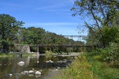 | Albright Bridge | structure | 1998 | 98000776 |
 | Kendall Young Public Library | building | 1983 | 83000361 |
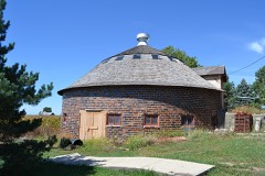 | William Oakland Round Barn | building | 1986 | 86001434 |
 | Schultz Brothers Drug Store | building | 1996 | 96000518 |
 | State Bank of Stratford | building | 1983 | 83000362 |
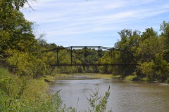 | Tremaine Bridge | structure | 1998 | 98000519 |
 | Webster City Post Office | building | 1982 | 82002619 |
 | William J. and Hattie J. Zitterell House | building | 1996 | 96000057 |
Every wildfire the federal occurrence database records inside this county: 66 of them, burning about 370 acres. 1 started naturally and 1 was recorded as arson. Each settlement page carries the fires within five miles of it.
| Reported cause | Fires |
|---|---|
| Missing data/not specified/undetermined | 41 |
| Debris and open burning | 14 |
| Equipment and vehicle use | 7 |
| Smoking | 2 |
| Natural | 1 |
| Arson/incendiarism | 1 |
The five largest, by the area the report gives. None of them was recorded as arson.
| Date | Cause | Size | Reported by | Name on the report |
|---|---|---|---|---|
| 21 April 2010 | Missing data/not specified/undetermined | 160 acres | Iowa Department of Natural Resources | 1900 BLOCK 310TH ST., STANHOPE, IOWA |
| 4 April 2011 | Missing data/not specified/undetermined | 40 acres | Iowa Department of Natural Resources | 380TH AND OLSON AVE, IA |
| 11 April 2014 | Debris and open burning | 40 acres | Iowa Department of Natural Resources | not named |
| 10 April 2010 | Missing data/not specified/undetermined | 18 acres | Iowa Department of Natural Resources | BAUER SLOUGH- ON KANTOR AVE NE OF KAMRAR, IOWA |
| 31 March 2010 | Missing data/not specified/undetermined | 11 acres | Iowa Department of Natural Resources | 1800 BLOCK 330TH ST., STANHOPE, IOWA |
| 5 March 2009 | Missing data/not specified/undetermined | 10 acres | Iowa Department of Natural Resources | not named |
| 17 November 2009 | Missing data/not specified/undetermined | 7.0 acres | Iowa Department of Natural Resources | not named |
| 10 April 2009 | Missing data/not specified/undetermined | 5.0 acres | Iowa Department of Natural Resources | not named |
Every settlement page carries the fires within five miles of it - see the settlement index below.
The NOAA Storm Events Database holds 439 reports for this county, causing 2 deaths, 17 injuries and about $46,325,800 in recorded property damage. Each settlement page carries the reports that name it.
| Kind of event | Reports |
|---|---|
| Hail | 149 |
| Thunderstorm Wind | 134 |
| Tornado | 56 |
| Heavy Rain | 35 |
| Flash Flood | 21 |
| Flood | 21 |
| Funnel Cloud | 19 |
| Lightning | 4 |
The most serious of them, by death, then injury, then recorded damage. The accounts are quoted exactly as the forecast office filed them.
| When | Event | Place named | Harm | What the report says |
|---|---|---|---|---|
| November 2005 | Tornado (F3) | Stratford | 1 killed, 3 hurt, $11,700,000 | Tornado moved from Webster County in to Hamilton County. One woman was killed when her house collapsed. |
| June 2008 | Flash Flood | Kamrar | 1 killed, $50,000 | Numerous roads impassible across Hamilton County due to flash flooding. |
| June 1979 | Tornado (F2) | not stated | 10 hurt, $250,000 | no account filed |
| April 1999 | Thunderstorm Wind | Ellsworth | 4 hurt, $20,000 | no account filed |
| May 1989 | Tornado (F4) | not stated | $25,000,000 | no account filed |
| March 1990 | Tornado (F2) | not stated | $2,500,000 | no account filed |
| July 2010 | Thunderstorm Wind | Webster City | $250,000 | Local law enforcement reports trees and power lines down at several locations around Hamilton County with the bulk of the damage in the Webster City and Kamrar areas. Widespread power outages after the storm had only been partly restored by morning. |
| April 2007 | Flood | Webster City | $250,000 | no account filed |
| June 1990 | Tornado (F1) | not stated | $250,000 | no account filed |
| October 1980 | Tornado (F1) | not stated | $250,000 | no account filed |
| June 1979 | Tornado (F2) | not stated | $250,000 | no account filed |
| June 1974 | Tornado (F2) | not stated | $250,000 | no account filed |
| March 2019 | Flood | Highview | $200,000 | Emergency manager reported that Highway 69 near Jewell had water partially covering the road. Several secondary roads, mainly gravel, had water over them as well. |
| August 2010 | Flood | Stanhope | $200,000 | Highway 17 was still closed due to flooding. County Highway R27 also closed south of Highway 175. Numerous gravel roads under several feet of water. |
| June 1998 | Thunderstorm Wind | Blairsburg | $200,000 | no account filed |
| June 1996 | Flash Flood | Jewell | $200,000 | no account filed |
| December 2021 | Tornado (EF2) | Stratford | $180,000 | This tornado entered Hamilton County from Webster County just south of Stratford and passed just south and east of town. This produced tree damage and completely destroyed an outbuilding northeast of town. The tornado continued to produce damage northeast of Stratford to outbuildings and trees before entering the Boone River valley and dissipating south several miles south of Webster City. |
| June 2014 | Hail | Stanhope | $150,000 | Up to baseball size hail across town with tree damage from strong winds. |
| August 1998 | Flash Flood | Webster City | $150,000 | no account filed |
| December 2021 | Tornado (EF2) | Stratford | $100,000 | This tornado entered Hamilton County from Webster County. The tornado produced damage to multiple large utility poles along several county roads to the south and east of Stratford. The tornado finally lifted northwest of Stanhope as it approached the Boone River valley. |
| September 2018 | Flood | Stratford | $100,000 | The Boone River at Webster City crested at 14.40 feet on 23 September 2018 at 1800 UTC. |
| August 2010 | Flash Flood | Stanhope | $100,000 | Hamilton County Law Enforcement reports Highway 17 closed in Stanhope with water 3 feet deep over roads and storm sewers backing up into homes. |
| July 2010 | Flash Flood | Webster City | $100,000 | Local law enforcement reports manhole covers blown off and streets flooded in Webster City. At least 2 cars that attempted to drive through the water were flooded and stalled. |
| June 2008 | Thunderstorm Wind | Williams | $100,000 | A hog containment building was destroyed. |
| June 2010 | Flood | Webster City | $100,000 | no account filed |
| June 2004 | Flash Flood | Countywide | $100,000 | no account filed |
| August 2014 | Tornado (EF0) | Kamrar | $95,000 | Brief tornado formed about 4 miles southwest of Kamrar and moved east southeast for its entire length. The tornado destroyed 3 grain bins at a farmstead along with crop damage. Tornado was found and rated using high resolution satellite imagery. |
| May 2024 | Tornado (EF1) | Ellsworth | $80,000 | Trained spotter reported damage on both sides of Interstate 35 in conjunction with this tornado. The tornado also tossed over 2 semis that were on the interstate. A hog confinement building was partially destroyed providing the EF1 damage. |
| August 2014 | Tornado (EF0) | Kamrar | $75,000 | Brief tornado developed about 2.5 miles southwest of Kamrar and moved east southeast. This tornado took part of the roof off a confinement building along with crop damage along its path. Tornado was found and rated using high resolution satellite imagery. |
| November 2005 | Tornado (F1) | Ellsworth | $75,000 | Tornado moved from Story County and across southeast Hamilton County, then into Hardin County. |
| June 2008 | Flood | Webster City | $75,000 | no account filed |
| June 1998 | Flash Flood | Webster City | $75,000 | no account filed |
| December 2021 | Tornado (EF0) | Homer | $70,000 | This tornado moved into Hamilton County from Webster County. This tornado moved northeast through rural portions of Hamilton county southwest and west of Webster City. The tornado passed over the US Highway 20 interchange with Stagecoach Road and then did damage to an industrial plant along 220th Street to the west of Webster City. The tornado dissipated a short time later. |
| April 2001 | Tornado (F1) | Webster City | $70,000 | Two farm buildings blown down in rural area south of Webster City. |
| August 2015 | Flash Flood | Stratford | $50,000 | Hamilton County Law Enforcement reported road closures due to heavy rain and flooding. Locations include along Highway 175 from Stratford to Stanhope. One retirement home was evacuated due to high water. |
| August 2011 | Thunderstorm Wind | Webster City | $50,000 | Extensive tree damage throughout the town of Webster City. Multiple tree limbs down, each about a foot in diameter. |
| July 2010 | Flash Flood | Webster City | $50,000 | Webster City Police reported that the city campgrounds were closed and the intersection of Linn St and Oak Ave was also closed. Additionally...Hamilton County Sheriff reported a few gravel roads were flooded in the northern part of the county. |
| March 2008 | Flood | Ellsworth | $50,000 | Water was 3 feet deep with a wash out on 400th Street, at the intersection of 400th Street and Vail Ave. in southern Hamilton County. The shoulder was completely washed out as well. |
| April 2008 | Tornado (EF0) | Stonega | $50,000 | A trained spotter sent a photo of a tornado and had driven back to the area where it was sighted. Tree damage and minor damage was noted on three farmsteads with the tornado track toward the southeast. |
| June 2008 | Flood | Webster City | $50,000 | Boone River was way out of its banks with numerous roads under water. Many homes had basement flooding and manhole covers blew off from the water pressure. |
| August 2007 | Flood | Stratford | $50,000 | no account filed |
| March 2007 | Flood | Stratford | $50,000 | no account filed |
| June 2007 | Flash Flood | Kamrar | $50,000 | no account filed |
| May 2005 | Lightning | Webster City | $50,000 | no account filed |
| June 2004 | Hail | Stratford | $50,000 | no account filed |
| September 2000 | Hail | Ellsworth | $50,000 | no account filed |
| April 1998 | Flood | Webster City | $50,000 | no account filed |
| September 1994 | Thunderstorm Wind | Jewell | $50,000 | no account filed |
| June 2003 | Thunderstorm Wind | Jewell | $40,000 | no account filed |
| April 2001 | Thunderstorm Wind | Stratford | $40,000 | no account filed |
| September 2000 | Hail | Ellsworth | $40,000 | no account filed |
| September 2000 | Hail | Webster City | $40,000 | no account filed |
| June 1998 | Thunderstorm Wind | Blairsburg | $40,000 | no account filed |
| June 1998 | Thunderstorm Wind | Williams | $35,000 | no account filed |
| June 1998 | Thunderstorm Wind | Ellsworth | $35,000 | no account filed |
| June 2008 | Thunderstorm Wind | Williams | $30,000 | Grain bin on the road and power lines down. Possible tornado damage. |
| October 2002 | Thunderstorm Wind | Stratford | $30,000 | no account filed |
| April 2001 | Thunderstorm Wind | Stanhope | $30,000 | no account filed |
| September 2000 | Hail | Kamrar | $30,000 | no account filed |
| August 2015 | Flash Flood | Randall | $25,000 | Public reported D65 west of Randall has been topped with water flowing over it in a couple of spots. Water also reported over several other county roads west of Randall. |
The Survey's mineral resources record lists 21 workings inside this county. 3 still produce and 18 are closed or unrecorded. Each settlement page carries the workings within five miles of it.
| Commodity | Workings |
|---|---|
| Sand and Gravel, Construction | 18 |
| Stone, Crushed/Broken | 3 |
The least common of them first, because a county's hundredth gravel pit says nothing its first ten did not.
| Where | Site | Commodity | Status | Recorded |
|---|---|---|---|---|
| Daniels Quarry | Stone, Crushed/Broken | Past Producer | ||
| Moberly Quarry | Stone, Crushed/Broken | Producer | ||
| Twedt-County Line Quarry | Stone, Crushed/Broken | Past Producer | ||
| Ahart Pit | Sand and Gravel, Construction | Past Producer | ||
| Forrester Pit | Sand and Gravel, Construction | Past Producer | ||
| Grandgeorge Pit | Sand and Gravel, Construction | Producer | ||
| Henderson Pit | Sand and Gravel, Construction | Past Producer | ||
| I H Knudson | Sand and Gravel, Construction | Past Producer | ||
| Ishams Pit | Sand and Gravel, Construction | Past Producer | ||
| Joseph Olson | Sand and Gravel, Construction | Past Producer | ||
| Luppes Pit | Sand and Gravel, Construction | Past Producer | ||
| M M Stark | Sand and Gravel, Construction | Past Producer | ||
| Mortveidt Pit | Sand and Gravel, Construction | Producer | ||
| Pierce Pit | Sand and Gravel, Construction | Past Producer | ||
| Stark Pit | Sand and Gravel, Construction | Past Producer | ||
| Storgland | Sand and Gravel, Construction | Past Producer | ||
| Teig Pit | Sand and Gravel, Construction | Past Producer | ||
| Unknown | Sand and Gravel, Construction | Past Producer | ||
| Unknown | Sand and Gravel, Construction | Past Producer | ||
| Unknown | Sand and Gravel, Construction | Past Producer | ||
| Unknown | Sand and Gravel, Construction | Past Producer |
Named settlements recorded in the Geographic Names Information System, each with the topographic sheets covering it. Villages, hamlets and abandoned places alike. Each is shown with the nearest named watercourse or landform and the survey quadrangle it falls on.
Blairsburg township · 50595 · Blairsburg quadrangle
9 sheets, 1954 to 1993
No longer a settlement
Webster City city · 50595 · On Lyons Creek · Webster City quadrangle
9 sheets, 1954 to 1993
The vanished settlements of Hamilton County: the places named above that are no longer on the map.