BlockBefore
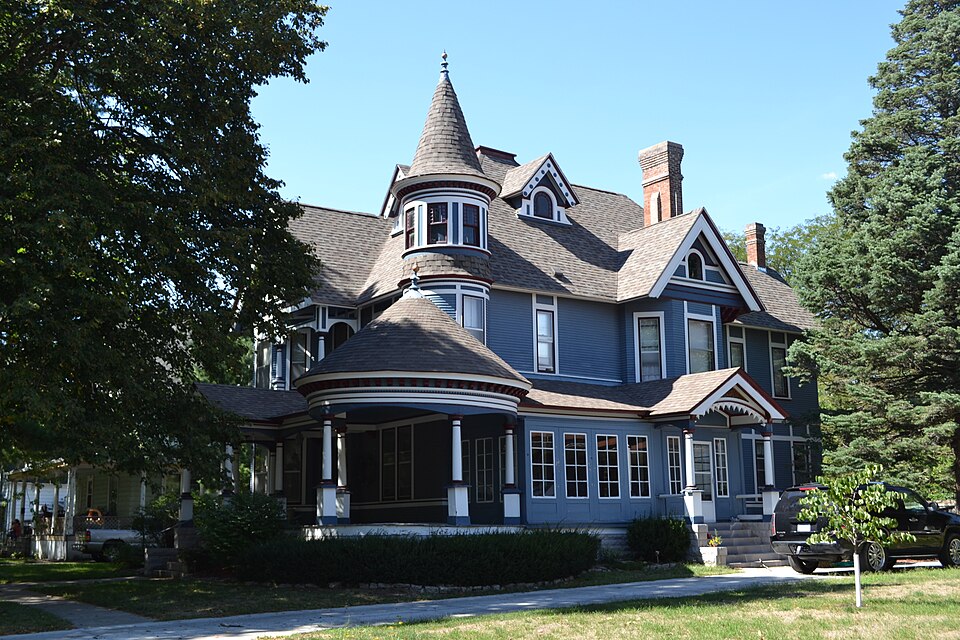
Photograph of William J. and Hattie J. Zitterell House
Photograph by Ann Sullivan-Larson, CC BY-SA 3.0. Via Wikimedia Commons.

William J. and Hattie J. Zitterell House

Built in 1901 (Queen Anne style). Listed on the National Register of Historic Places in 1996.

From the record

“Zitterell House is a historic residence located in Webster City, Iowa, United States. Zitterell was a general contractor, and he served as president of the Iowa Master Builders Association twice.”

Wikipedia article William J. and Hattie J. Zitterell House, CC BY-SA 4.0.

One of 8 National Register listings published here for Hamilton County · listed in 1996 · category: Building · built in 1901, Queen Anne style.

Sources: the Wikipedia article · the case file at the National Archives · the National Register database, National Park Service

The listing

  • What is counted as historic. The nomination lists 1 building, 1 structure as contributing to the listing.
  • Listed as. Zitterell, William J. and Hattie J., House - the National Register files a house under its owner's surname.
  • Address. 821 Division St., Webster City, 50595
  • When was it listed? February 1996
  • Category. building
  • City. Webster City city
  • When was it built? 1901
  • Architectural style. Queen Anne style
  • National Register reference number. 96000057 - the number the National Park Service assigned this property when it was listed, and the key its nomination file is catalogued under at the National Archives.

Fires near this property

15 since 2009

Regional context, not property-specific evidence. The federal wildfire occurrence database lists 15 fires within 5 miles of William J. and Hattie J. Zitterell House between 2009 and 2020, burning about 17 acres in total. None started naturally. 1 was recorded as arson. Distance is straight-line from the map coordinates, so a fire counted here may appear on a neighbouring settlement's page as well.

Reported cause Fires
Missing data/not specified/undetermined9
Debris and open burning4
Arson/incendiarism1
Equipment and vehicle use1

The most recent of them, most recent first, with the day each was reported and the service that recorded it.

DateCause SizeReported by Name on the report
5 August 2020Missing data/not specified/undeterminedunder an acreIowa Department of Natural Resourcesnot named
29 July 2018Arson/incendiarismunder an acreIowa Department of Natural Resourcesnot named
30 May 2009Missing data/not specified/undeterminedunder an acreIowa Department of Natural Resourcesnot named
23 May 2016Missing data/not specified/undeterminedunder an acreIowa Department of Natural ResourcesWEBSTER CITY
5 April 2018Debris and open burning2.0 acresIowa Department of Natural Resourcesnot named
4 April 2016Debris and open burning5.0 acresIowa Department of Natural ResourcesWEBSTER CITY
30 April 2018Equipment and vehicle useunder an acreIowa Department of Natural Resourcesnot named
3 April 2019Missing data/not specified/undeterminedunder an acreIowa Department of Natural Resourcesnot named

Every fire recorded in Hamilton County

Mines and quarries near this property

7 within 5 miles

Regional context, not property-specific evidence. The federal mineral resources record lists 7 workings within 5 miles of William J. and Hattie J. Zitterell House: 5 past producers, 2 producers. 2 still produce. What was taken out: Sand and Gravel, Construction, Stone, Crushed/Broken. Distance is straight-line from the map coordinates, so a quarry counted here may appear on a neighbouring settlement's page as well.

Where SiteCommodity StatusRecorded
Daniels QuarryStone, Crushed/BrokenPast Producer
Moberly QuarryStone, Crushed/BrokenProducer
Ahart PitSand and Gravel, ConstructionPast Producer
Forrester PitSand and Gravel, ConstructionPast Producer
Grandgeorge PitSand and Gravel, ConstructionProducer
Pierce PitSand and Gravel, ConstructionPast Producer
UnknownSand and Gravel, ConstructionPast Producer

Every working recorded in Hamilton County

Storms near this property

60 of 83 shown

Regional context, not property-specific evidence. The National Weather Service names Webster City, the town this property stands in, in 83 storm reports between 1994 and 2025: 30 hail, 24 thunderstorm wind, 8 heavy rain, 6 flood. No death or injury is recorded in these reports. Each account below is quoted exactly as the forecast office filed it, from the NOAA Storm Events Database, and each date opens the federal record of that event.

WhenEvent Place namedHarm What the report says
July 2010Thunderstorm WindWebster City$250,000Local law enforcement reports trees and power lines down at several locations around Hamilton County with the bulk of the damage in the Webster City and Kamrar areas. Widespread power outages after the storm had only been partly restored by morning.
April 2007FloodWebster City$250,000no account filed
August 1998Flash FloodWebster City$150,000no account filed
July 2010Flash FloodWebster City$100,000Local law enforcement reports manhole covers blown off and streets flooded in Webster City. At least 2 cars that attempted to drive through the water were flooded and stalled.
June 2010FloodWebster City$100,000no account filed
June 2008FloodWebster City$75,000no account filed
June 1998Flash FloodWebster City$75,000no account filed
April 2001Tornado (F1)Webster City$70,000Two farm buildings blown down in rural area south of Webster City.
August 2011Thunderstorm WindWebster City$50,000Extensive tree damage throughout the town of Webster City. Multiple tree limbs down, each about a foot in diameter.
July 2010Flash FloodWebster City$50,000Webster City Police reported that the city campgrounds were closed and the intersection of Linn St and Oak Ave was also closed. Additionally...Hamilton County Sheriff reported a few gravel roads were flooded in the northern part of the county.
June 2008FloodWebster City$50,000Boone River was way out of its banks with numerous roads under water. Many homes had basement flooding and manhole covers blew off from the water pressure.
May 2005LightningWebster City$50,000no account filed
April 1998FloodWebster City$50,000no account filed
September 2000HailWebster City$40,000no account filed
June 2008Flash FloodWebster City$25,000Street flooding was reported in the city.
June 2004HailWebster City$25,000no account filed
August 2003Thunderstorm WindWebster City$25,000no account filed
July 2001FloodWebster City$25,000no account filed
August 2018Thunderstorm WindWebster City$20,000Public reported trees down, power lines down and power outages. Some streets were partially blocked by trees with some damage to structures. Time estimated by radar.
March 2017Thunderstorm WindWebster City$20,000Trained spotter reported a semi blown on its side on Highway 20 near Webster City. Time estimated via radar.
August 2018Thunderstorm WindWebster City$15,000Large branches of 10 to 12 inch diameter snapped off trees. Some power lines down in town.
August 2006Thunderstorm WindWebster City$15,000no account filed
May 1997LightningWebster City$15,000no account filed
June 2018Thunderstorm WindWebster City$10,000Public relayed a picture of a large tree down in town.
July 2011Thunderstorm WindWebster City$10,000Spotter reported multiple large tree branches down in town.
July 2013HailWebster City$10,000no account filed
June 2004HailWebster City$10,000no account filed
May 2001HailWebster City$10,000no account filed
April 2001Thunderstorm WindWebster City$10,000no account filed
September 2000HailWebster City$10,000no account filed
July 1999HailWebster City$10,000no account filed
June 1997Thunderstorm WindWebster City$10,000no account filed
July 2008Thunderstorm WindWebster City$5,000Ten to 15 inch tree branches down.
July 1995HailWebster City$5,000A weak cold front moved southeast across Iowa. The air mass was quite unstable, but at the same time capped by warm temperatures aloft. The freezing level was around 14,300 MSL. One cell was able to develop over north central Iowa. It moved southeast across Franklin, Wright, and Hamilton Counties. The storm became severe and produced hail up to golf ball and slightly larger in size. Reports indicated the hail covered the ground in a few areas. One area was the area north of Jewell. Hail of golf ball size fell north of Ellsworth, breaking out the window in one house. A window was also broken out of a state police car as well. The damage to crops was serious. A survey of the area revealed an area about 12 miles long and two to three miles wide from east of Webster City south to near Ellsworth suffered substantial damage. About one quarter of the crop was destroyed with damage well in excess of $1 million. The WSR 88D pictures indicated a strong circulation in the cell. About that time a funnel cloud was reported southeast of Rowan in Wright County. Later as the storm passed through Hamilton County, another funnel cloud was observed near Blairsburg. The thunderstorm collapsed about as quickly as it formed. It dissipated over Story County.
July 2013HailWebster City$5,000no account filed
June 2004HailWebster City$5,000no account filed
May 2004HailWebster City$5,000no account filed
June 2002HailWebster City$5,000no account filed
July 1999HailWebster City$5,000no account filed
August 1995Thunderstorm WindWebster City$5,000no account filed
September 1994HailWebster City$5,000no account filed
July 2013HailWebster City$3,000no account filed
May 2007HailWebster City$3,000no account filed
June 2002HailWebster City$3,000no account filed
September 2000HailWebster City$3,000no account filed
September 2000Thunderstorm WindWebster City$3,000no account filed
July 2005Thunderstorm WindWebster City$2,000no account filed
June 2004HailWebster City$2,000no account filed
June 2002HailWebster City$2,000no account filed
July 1999HailWebster City$2,000no account filed
August 2025LightningWebster City$1,000A large tree was struck by lightning at 833 am. Delayed report.
November 2003HailWebster City$1,000no account filed
June 2000Thunderstorm WindWebster City$1,000no account filed
June 1994Tornado (F0)Webster City$500no account filed
July 2025Thunderstorm WindWebster City-Tree limbs up to 3 to 4 inches down in Webster City.
May 2024Thunderstorm WindWebster City-No comments included in this report.
May 2024Thunderstorm WindWebster City-Large tree branches down and power outages. Simi crashes along I-35.
May 2024Thunderstorm WindWebster City-Local media reported power outages and tree limbs down.

Every storm recorded in Hamilton County

Map coverage status

No historic map-sheet match is published for this property yet. That does not mean no map exists. This record needs a coordinate-quality review before it can be joined to a sheet boundary. Browse the county's mapped places while that work is pending.

Listed places nearby

4 within 8 miles

Other National Register properties close enough to walk or drive between, ordered by distance from this one. Both positions come from the same geocoding pass that matched these properties to their map sheets.

Photograph PropertyDistance Listed
Webster City Post Office0.3 miles1982
Kendall Young Public Library0.9 miles1983
Albright Bridge4.4 miles1998
Tremaine Bridge5.7 miles1998

Sources for this property

National Archives recordThe nomination case file for reference 96000057 in Record Group 79.
Wikipedia articleCommunity-written account of this property, licensed CC BY-SA.
Hamilton CountyAll 8 listed properties in this county.

Provenance

  • Listing record. National Park Service National Register of Historic Places, listed-properties dataset, current to 2026-05-22.
  • Map join. Address geocoded through the United States Census geocoder, then tested against the published boundary of every sheet in the USGS Historical Topographic Map Collection.
  • How this page is made. Listing fields come from federal records; map-sheet coverage is a labelled coordinate-to-boundary calculation, not a source-field claim.
  • Wildfire. Short, Karen C. 2022. Spatial wildfire occurrence data for the United States, 1992-2020 [FPA_FOD_20221014]. 6th Edition. Fort Collins, CO: Forest Service Research Data Archive. https://doi.org/10.2737/RDS-2013-0009.6 Collected with United States Government funding and usable without additional permissions or fees.
  • Mines and quarries. USGS Mineral Resources Data System (MRDS) https://mrdata.usgs.gov/mrds/ A work of the United States government, no copyright under 17 U.S.C. 105.
  • Storms. NOAA National Centers for Environmental Information, Storm Events Database https://www.ncei.noaa.gov/stormevents/ A work of the United States government, no copyright under 17 U.S.C. 105. Narratives are quoted verbatim from the National Weather Service report and are not edited or summarised.