 Block
From the record
5 National Register listings published here.
Sources: the National Register database, National Park Service
16 topographic sheets cover 5 settlements here, and 5 properties are on the National Register of Historic Places.
5 National Register listings published here.
Sources: the National Register database, National Park Service
Every property in this county listed on the National Register of Historic Places, with the year it was listed and the federal nomination document.
| Photograph | Property | Type | Listed | Reference |
|---|---|---|---|---|
 | Alvin Bushnell Bell House | building | 1983 | 83000369 |
 | Ida County Courthouse | building | 1974 | 74000787 |
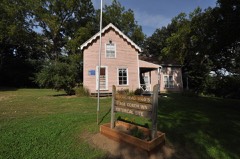 | Moorehead Stagecoach Inn | building | 1974 | 74000788 |
| Dr. Francis B. Warnock House | building | 1988 | 88001945 | |
| Waveland Round Barn | building | 1986 | 86001438 |
Every wildfire the federal occurrence database records inside this county: 50 of them, burning about 1,276 acres. None started naturally and none was recorded as arson. Each settlement page carries the fires within five miles of it.
| Reported cause | Fires |
|---|---|
| Missing data/not specified/undetermined | 30 |
| Debris and open burning | 12 |
| Equipment and vehicle use | 5 |
| Smoking | 2 |
| Misuse of fire by a minor | 1 |
The five largest, by the area the report gives. None of them was recorded as arson.
| Date | Cause | Size | Reported by | Name on the report |
|---|---|---|---|---|
| 9 April 2014 | Debris and open burning | 600 acres | Iowa Department of Natural Resources | not named |
| 29 October 2011 | Missing data/not specified/undetermined | 220 acres | Iowa Department of Natural Resources | 5358 240TH ST. BATTLE CREEK, IA 51006, IA |
| 22 April 2020 | Debris and open burning | 80 acres | Iowa Department of Natural Resources | not named |
| 10 December 2006 | Missing data/not specified/undetermined | 50 acres | Iowa Department of Natural Resources | not named |
| 18 March 2015 | Debris and open burning | 45 acres | Iowa Department of Natural Resources | not named |
| 21 March 2009 | Missing data/not specified/undetermined | 35 acres | Iowa Department of Natural Resources | not named |
| 18 March 2011 | Missing data/not specified/undetermined | 30 acres | Iowa Department of Natural Resources | 2200 BLOCK EAGLE AVE, IA |
| 3 April 2011 | Missing data/not specified/undetermined | 30 acres | Iowa Department of Natural Resources | 5212 210TH ST., BATTLE CREEK, IA, IA |
Every settlement page carries the fires within five miles of it - see the settlement index below.
The NOAA Storm Events Database holds 262 reports for this county, causing no deaths, 5 injuries and about $8,775,000 in recorded property damage. Each settlement page carries the reports that name it.
| Kind of event | Reports |
|---|---|
| Hail | 130 |
| Thunderstorm Wind | 93 |
| Tornado | 16 |
| Flood | 11 |
| Flash Flood | 10 |
| Heavy Rain | 1 |
| Lightning | 1 |
The most serious of them, by death, then injury, then recorded damage. The accounts are quoted exactly as the forecast office filed them.
| When | Event | Place named | Harm | What the report says |
|---|---|---|---|---|
| July 2008 | Lightning | Galva | 2 hurt, $5,000 | Lightning struck a car, slightly injuring the two occupants, and damaging the car's engine and electrical system. |
| June 1984 | Tornado (F2) | not stated | 1 hurt, $2,500,000 | no account filed |
| June 1984 | Tornado (F2) | not stated | 1 hurt, $2,500,000 | no account filed |
| April 1985 | Thunderstorm Wind | not stated | 1 hurt | no account filed |
| March 2019 | Flood | Battle Creek | $810,000 | Flooding resulted in extensive damage to public infrastructure including numerous county and township roads, culverts, and some bridges. |
| June 2014 | Flood | Galva | $500,000 | Repeated heavy rains caused record flooding of the Maple River. Most of the flooding was to farmland and roads, but a few homes and businesses were flooded, mainly in basements, especially in the communities of Galva and Ida Grove. The river crested at a record 6.37 feet above flood stage near Galva on June 17th. |
| July 1994 | Thunderstorm Wind | Ida Grove | $500,000 | no account filed |
| June 1994 | Tornado (F1) | Galva | $500,000 | no account filed |
| July 1979 | Tornado (F1) | not stated | $250,000 | no account filed |
| July 1969 | Tornado (F3) | not stated | $250,000 | no account filed |
| June 1957 | Tornado (F2) | not stated | $250,000 | no account filed |
| December 2021 | Tornado (EF1) | Battle Creek | $200,000 | A tornado formed in an open field between 280th and 290th Streets near the Woodbury and Ida County line southwest of Battle Creek. The tornado tracked northeast for around one mile before it removed shingles from a house southwest of Battle Creek. As the tornado continued northeast, four additional farmsteads were impacted with|several outbuildings damaged or destroyed. Several trees were damaged and a few power poles were snapped north of Battle Creek. The tornado crossed U.S. Highway 59 just north of 190th Street, and lifted approximately 7 miles north of Ida Grove. The average path width was 50 yards and the maximum estimated wind speed was 100 mph. Property damage costs are a rough estimate. |
| April 2011 | Tornado (EF1) | Galva | $100,000 | A tornado severely damaged a farmstead; taking the roof off of a house and destroying numerous outbuildings. The tornado also damaged outbuildings at another farmstead, snapped at least 5 power poles, and damaged an outbuilding at an ethanol plant. The tornado also caused tree damage. |
| August 2010 | Thunderstorm Wind | Holstein | $100,000 | Thunderstorm winds destroyed a machine shed, heavily damaged a large shed at a manufacturing plant, overturned a livestock trailer and a large grain wagon, destroyed a small garage, destroyed or damaged several small sheds, and caused tree damage, including several large trees blown down. A house was damaged by debris from the destroyed machine shed, while other buildings and vehicles sustained damage from falling trees and tree debris. The winds also caused an unknown amount of damage to corn crops. |
| December 2021 | Tornado (EF0) | Galva | $75,000 | The tornado developed 2 miles north-northwest of Galva, one-half mile southwest of the intersection of 120th Street and Landmark Avenue. The tornado tracked northeast to a farmstead on the northeast corner of the intersection, where a hoop barn was destroyed and the roof partially removed from a residence. The tornado exited Ida County 4 miles north of Galva just east of Marshal Avenue at 1700CST. The tornado clipped the far southeast corner of Cherokee County, then entered Buena Vista County at 1701CST, where the tornado lifted one mile southwest of Alta at 1706CST. The tornado was rated EF0 in Ida County, EFU in Cherokee County, and EF1 in Buena Vista County. The average path width in Ida County was 50 yards and the maximum estimated wind speed was 85 mph. Property damage costs are a rough estimate. |
| April 2011 | Tornado (EF2) | Arthur | $50,000 | A tornado destroyed or heavily damaged two grain bins and two outbuildings on a farmstead. The tornado also caused mainly shingle damage to a house and garage on the same farmstead. Trees, power poles, and power lines were also damaged. |
| July 1994 | Thunderstorm Wind | Arthur | $50,000 | no account filed |
| June 2004 | Thunderstorm Wind | Arthur | $30,000 | Thunderstorm winds destroyed a garage, caused minor roof damage to homes, and toppled two empty grain bins. The winds also caused tree damage, including numerous branches down and the tops of several trees broken off. |
| June 2003 | Thunderstorm Wind | Holstein | $20,000 | Thunderstorm winds caused tree and power line damage. Several trees were blown down, including a large tree which blocked U.S. Highway 59. The downed power lines resulted in power outages. |
| April 2011 | Thunderstorm Wind | Ida Grove Muni Arpt | $10,000 | Thunderstorm winds damaged farm buildings. |
| August 2010 | Thunderstorm Wind | Galva | $10,000 | Thunderstorm winds blew the roof off a barn, blew down power lines, and caused tree damage. |
| June 1996 | Hail | Holstein | $10,000 | no account filed |
| June 2011 | Thunderstorm Wind | Battle Creek | $5,000 | Thunderstorm winds blew down large branches and power lines, with a resulting power outage. |
| June 2010 | Hail | Holstein | $5,000 | Golf ball size hail damaged a roof. |
| July 1994 | Thunderstorm Wind | Ida Grove | $5,000 | A stationary frontal system remained just to the northwest of Iowa. The airmass was extremely unstable with convective available potential energy between 5000 and 6000 J-Kg-1 over the northwest part of Iowa. Feeding into the area was an area of dew point temperatures between 75 and 80 degrees. This set the stage for explosive thunderstorm development. A small area of thunderstorms fired up over northwest Iowa in Woodbury County. As the evening progressed, a HP Supercell developed over the western part of the county and remained nearly stationary for several hours. Actually the cell would drift slightly northeast with the environmental winds, then back-develop over the same area. This resulted in flash flooding over a part of Woodbury County as around 5 inches of rain fell in two to three hours time. The cell spawned numerous funnel clouds and one tornado. The tornado touched down northwest of Salix, then drifted slowly southeast. Damage occurred in the Salix area. First to be hit was in the rural areas northwest of town, where several grain bins were destroyed. As the tornado moved into the city, two houses were damaged and two others destroyed. A full size car was lifted and carried from a driveway, then deposited on its top. Damage estimates were in the $200,000 range. Fortunately, there were no injuries or deaths reported. The tornado was actually visible for nearly two hours. In all probability, this was a family of tornadoes from the parent supercell. Other than the one cell, severe weather was rather spotty even though the storms developed into a bow configuration. Sixty to 70 MPH winds were reported southeast of Le Mars as the gust front passed. High winds downed power lines in Onawa. The storms acted very much like the storms of the previous night. A well defined outflow boundary was depicted on the WSR-88D radar at Des Moines. The boundary advanced during the night until it was about 100 miles ahead of the complex by sunrise. This cut off the inflow to the storms. Lightning damage was reported in Sioux City. In one strike, a garage was struck by lightning causing minor damage. Later, a house was struck in town. The house was set on fire. |
| June 1999 | Thunderstorm Wind | Ida Grove | $5,000 | no account filed |
| July 1994 | Thunderstorm Wind | Arthur | $5,000 | no account filed |
| June 1994 | Thunderstorm Wind | Galva | $5,000 | no account filed |
| July 1994 | Hail | Holstein | $5,000 | no account filed |
| July 1994 | Thunderstorm Wind | Ida Grove | $5,000 | no account filed |
| July 1994 | Thunderstorm Wind | Battle Creek | $5,000 | no account filed |
| June 1992 | Tornado (F0) | not stated | $2,500 | no account filed |
| August 1991 | Tornado (F0) | not stated | $2,500 | no account filed |
| June 2001 | Thunderstorm Wind | Ida Grove | $2,000 | Thunderstorm winds lifted an empty 11 thousand bushel metal grain bin from its concrete base, and dropped it in a nearby field, destroying it. |
| August 2020 | Thunderstorm Wind | Arthur | $1,000 | Four or five large branches were taken down by thunderstorm winds, along with numerous smaller branches. Property damage costs are rough estimates. Crop damage is an estimate from insured losses. Information provided by the United States Department of Agriculture. |
| August 2020 | Thunderstorm Wind | Ida Grove | $1,000 | Several large tree limbs were strewn across Highway 59. Property damage costs are rough estimates. |
| April 2011 | Thunderstorm Wind | Ida Grove Muni Arpt | $1,000 | Thunderstorm winds damaged the roof of an outbuilding. |
| March 2025 | Thunderstorm Wind | Galva | - | A 58 mph thunderstorm wind gust was measured by a personal weather station. |
| March 2025 | Thunderstorm Wind | Arthur | - | A 59 mph thunderstorm wind gust was measured by a personal weather station. |
| July 2025 | Thunderstorm Wind | Galva | - | Thunderstorm wind gusts were measured by a personal weather station. |
| August 2025 | Thunderstorm Wind | Galva | - | Thunderstorm wind gusts were measured by a personal weather station. |
| August 2025 | Hail | Holstein | - | Intermittent hail was not quite the size of a golf ball at times. |
| June 2025 | Thunderstorm Wind | Battle Creek | - | Numerous large tree limbs were taken down by thunderstorm wind gusts, some limbs in excess of 12 inches in diameter. Power was knocked out across town due to tree limbs falling on power lines. |
| June 2025 | Thunderstorm Wind | Holstein | - | Thunderstorm wind gusts removed several large tree limbs at Holstein Park. |
| June 2024 | Thunderstorm Wind | Arthur | - | Thunderstorm winds damaged an outbuilding and dented in a grain bin. |
| June 2024 | Flood | Holstein | - | The Little Sioux River near Correctionville rose above flood stage the morning of June 23rd, cresting around 11.92 feet above flood stage (30.92 feet) on June 25th. This crest is in the Major Stage and broke the previous record. The river stayed above flood stage into July. |
| June 2024 | Thunderstorm Wind | Arthur | - | Tree limbs from 10 to 12 inches in diameter fell onto power lines from the electric pole to garage. Winds were accompanied by hail up to dime size and torrential rainfall. Crop damage is an estimate from insured losses. Information provided by the United States Department of Agriculture. |
| April 2023 | Hail | Arthur | - | Occasional hail up to quarter size fell 8 miles south of Arthur. |
| April 2022 | Thunderstorm Wind | Ida Grove Muni Arpt | - | Numerous tree branches were downed by thunderstorm winds, with one approximately 8 inch pine tree split. |
| May 2022 | Thunderstorm Wind | Holstein | - | A large tree was knocked down by strong winds, estimate at least to 70 mph. Winds were strong enough to bow house walls and push an old barn off its foundation. |
| April 2022 | Thunderstorm Wind | Galva | - | Thunderstorm winds downed a few 6- to 9-inch diameter tree limbs. |
| May 2022 | Thunderstorm Wind | Galva | - | Thunderstorm winds damaged several outbuildings and downed several trees. |
| May 2022 | Thunderstorm Wind | Galva | - | Thunderstorm winds downed a large tree. |
| May 2022 | Thunderstorm Wind | Galva | - | Thunderstorm winds uprooted or snapped several trees. |
| May 2022 | Thunderstorm Wind | Ida Grove | - | Thunderstorm wind gusts brought down numerous large tree limbs, with several trees snapped or uprooted. |
| June 2021 | Thunderstorm Wind | Ida Grove | - | Several power lines and tree branches were reported down across the city. |
| August 2021 | Hail | Arthur | - | Crops were badly damaged by large hail. Crop damage is an estimate from insured losses. Information provided by the United States Department of Agriculture. |
| May 2021 | Hail | Galva | - | Crop damage is an estimate from insured losses. Information provided by the United States Department of Agriculture. |
| June 2021 | Hail | Ida Grove | - | Crop damage is an estimate from insured losses. Information provided by the United States Department of Agriculture. |
| August 2021 | Hail | Arthur | - | Fields were shredded by large hail. |
The Survey's mineral resources record lists 8 workings inside this county. 1 still produces and 7 are closed or unrecorded. Each settlement page carries the workings within five miles of it.
| Commodity | Workings |
|---|---|
| Sand and Gravel, Construction | 8 |
The least common of them first, because a county's hundredth gravel pit says nothing its first ten did not.
| Where | Site | Commodity | Status | Recorded |
|---|---|---|---|---|
| Buck Pit | Sand and Gravel, Construction | Past Producer | ||
| Galva Pit | Sand and Gravel, Construction | Producer | ||
| Unknown | Sand and Gravel, Construction | Past Producer | ||
| Unknown | Sand and Gravel, Construction | Past Producer | ||
| Unknown | Sand and Gravel, Construction | Past Producer | ||
| Unknown | Sand and Gravel, Construction | Past Producer | ||
| Unknown | Sand and Gravel, Construction | Past Producer | ||
| Unknown | Sand and Gravel, Construction | Past Producer |
Named settlements recorded in the Geographic Names Information System, each with the topographic sheets covering it. Villages, hamlets and abandoned places alike. Each is shown with the nearest named watercourse or landform and the survey quadrangle it falls on.
Maple township · 51006 · On Lund Creek · Battle Creek quadrangle
9 sheets, 1954 to 1985