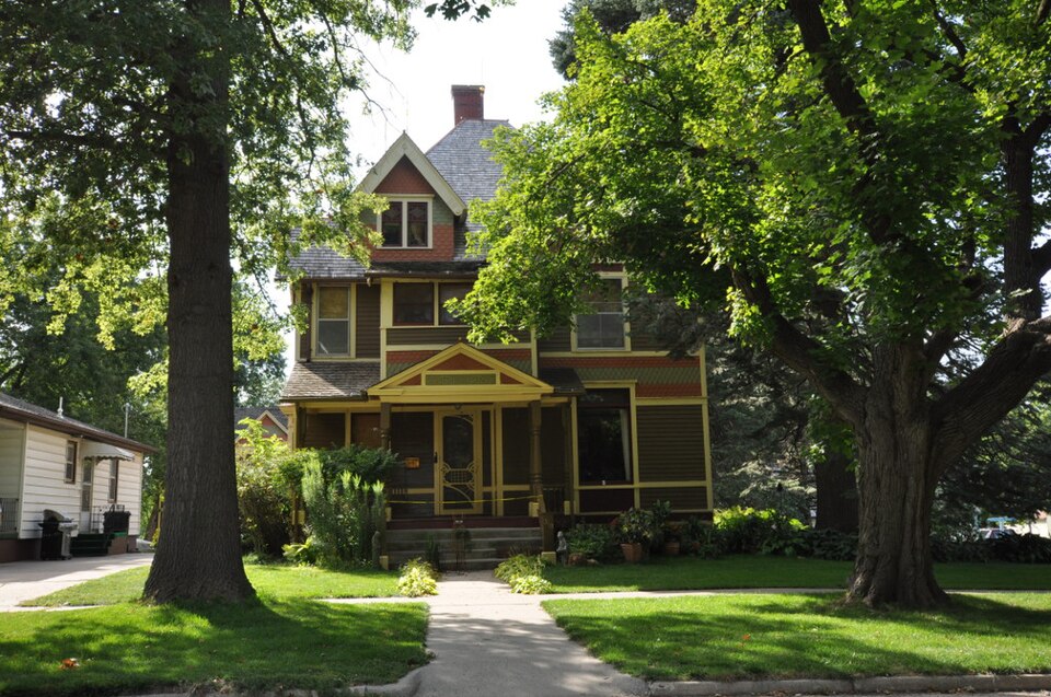
Listed on the National Register of Historic Places in 1983.
From the record
“The Alvin Bushnell Bell House, also known as the Kee House, is a historic building located in Ida Grove, Iowa, United States. Alvin Bell was a native of Indiana and moved to Ida County in 1880.”
Wikipedia article Alvin Bushnell Bell House, CC BY-SA 4.0.
One of 5 National Register listings published here for Ida County · listed in 1983 · category: Building.
National Register reference number.83000369- the number the National Park Service assigned this property when it was listed, and the key its nomination file is catalogued under at the National Archives.
Fires near this property
2 since 2011
Regional context, not property-specific
evidence. The
federal wildfire occurrence database
lists 2 fires within 5 miles of Alvin Bushnell Bell House
between 2011 and 2015, burning about 222 acres in total. None started naturally. None was recorded as arson.
Distance is straight-line from the map coordinates, so a fire counted
here may appear on a neighbouring settlement's page as well.
Reported cause
Fires
Missing data/not specified/undetermined
2
The most recent of
them, most recent first, with the day each was reported and the service
that recorded it.
Regional context, not property-specific
evidence. The federal mineral resources record lists
1 working within 5 miles of Alvin Bushnell Bell House: 1 past producer.
None of them still produces. What was taken out: Sand and Gravel, Construction. Distance is straight-line from the
map coordinates, so a quarry counted here may appear on a neighbouring
settlement's page as well.
Regional context, not property-specific
evidence. The National Weather Service names
Ida Grove, the town this property stands in, in 44 storm reports between 1994 and 2022: 21 hail, 18 thunderstorm wind, 3 flash flood, 1 tornado.
No death or injury is recorded in these reports. Each account below is quoted exactly as the forecast office
filed it, from the NOAA Storm Events Database, and each date
opens the federal record of that event.
A stationary frontal system remained just to the northwest of Iowa. The airmass was extremely unstable with convective available potential energy between 5000 and 6000 J-Kg-1 over the northwest part of Iowa. Feeding into the area was an area of dew point temperatures between 75 and 80 degrees. This set the stage for explosive thunderstorm development. A small area of thunderstorms fired up over northwest Iowa in Woodbury County. As the evening progressed, a HP Supercell developed over the western part of the county and remained nearly stationary for several hours. Actually the cell would drift slightly northeast with the environmental winds, then back-develop over the same area. This resulted in flash flooding over a part of Woodbury County as around 5 inches of rain fell in two to three hours time. The cell spawned numerous funnel clouds and one tornado. The tornado touched down northwest of Salix, then drifted slowly southeast. Damage occurred in the Salix area. First to be hit was in the rural areas northwest of town, where several grain bins were destroyed. As the tornado moved into the city, two houses were damaged and two others destroyed. A full size car was lifted and carried from a driveway, then deposited on its top. Damage estimates were in the $200,000 range. Fortunately, there were no injuries or deaths reported. The tornado was actually visible for nearly two hours. In all probability, this was a family of tornadoes from the parent supercell. Other than the one cell, severe weather was rather spotty even though the storms developed into a bow configuration. Sixty to 70 MPH winds were reported southeast of Le Mars as the gust front passed. High winds downed power lines in Onawa. The storms acted very much like the storms of the previous night. A well defined outflow boundary was depicted on the WSR-88D radar at Des Moines. The boundary advanced during the night until it was about 100 miles ahead of the complex by sunrise. This cut off the inflow to the storms. Lightning damage was reported in Sioux City. In one strike, a garage was struck by lightning causing minor damage. Later, a house was struck in town. The house was set on fire.
Snow melt and heavy rainfall (measured 0.77 inches 3 miles northeast of Battle Creek and 1.42 inches 4 miles south southeast of Arthur) resulted in significant flooding of agricultural lands. Levees in Ida Grove were nearly topped. Iowa Highway 175 was closed between Ida Grove and Battle Creek due to water flowing over the roadway. The Maple River at Ida Grove (gage site MIGI4) reached the highest stage on record cresting 9.76 feet above flood stage on March 14.
No historic map-sheet match is published
for this property yet. That does not mean no map exists. This record needs
a coordinate-quality review before it can be joined to a sheet boundary.
Browse the county's mapped places while that work is
pending.
Listed places nearby
3 within 8 miles
Other National Register properties close
enough to walk or drive between, ordered by distance from this one. Both
positions come from the same geocoding pass that matched these properties
to their map sheets.
Listing record. National Park Service National Register of Historic Places, listed-properties dataset, current to 2026-05-22.
Map join. Address geocoded through the United States Census geocoder, then tested against the published boundary of every sheet in the USGS Historical Topographic Map Collection.
How this page is made. Listing fields come from federal records; map-sheet coverage is a labelled coordinate-to-boundary calculation, not a source-field claim.
Wildfire. Short, Karen C. 2022. Spatial wildfire occurrence data for the United States, 1992-2020 [FPA_FOD_20221014]. 6th Edition. Fort Collins, CO: Forest Service Research Data Archive. https://doi.org/10.2737/RDS-2013-0009.6 Collected with United States Government funding and usable without additional permissions or fees.
Mines and quarries. USGS Mineral Resources Data System (MRDS) https://mrdata.usgs.gov/mrds/ A work of the United States government, no copyright under 17 U.S.C. 105.
Storms. NOAA National Centers for Environmental Information, Storm Events Database https://www.ncei.noaa.gov/stormevents/ A work of the United States government, no copyright under 17 U.S.C. 105. Narratives are quoted verbatim from the National Weather Service report and are not edited or summarised.
 Block