 Block
From the record
12 National Register listings published here.
Sources: the National Register database, National Park Service
18 topographic sheets cover 19 settlements here, and 12 properties are on the National Register of Historic Places.
12 National Register listings published here.
Sources: the National Register database, National Park Service
Every property in this county listed on the National Register of Historic Places, with the year it was listed and the federal nomination document.
| Photograph | Property | Type | Listed | Reference |
|---|---|---|---|---|
 | Cedar Valley Seminary | building | 1977 | 77000541 |
 | Nathaniel Cobb and Lucetia Baily Deering House | building | 2001 | 00001678 |
 | First Lutheran Church | building | 1976 | 76000795 |
 | Mitchell County Courthouse | building | 1977 | 77000542 |
 | Mitchell Powerhouse and Dam | structure | 1978 | 78001246 |
 | Osage Commercial Historic District | district | 2002 | 02001030 |
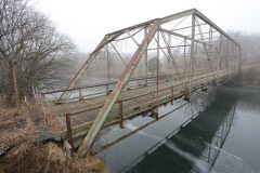 | Otranto Bridge | structure | 1998 | 98000495 |
| Our Savior's Lutheran Church | building | 2022 | 100007944 | |
| Saint Ansgar Public School | building | 2020 | 100004976 | |
| Nels Severson Barn | building | 1977 | 77000540 | |
 | Union Presbyterian Church | building | 1977 | 77000543 |
 | Walnut Grove School | building | 2002 | 02001028 |
Every wildfire the federal occurrence database records inside this county: 26 of them, burning about 164 acres. 1 started naturally and none was recorded as arson. Each settlement page carries the fires within five miles of it.
| Reported cause | Fires |
|---|---|
| Missing data/not specified/undetermined | 14 |
| Debris and open burning | 5 |
| Equipment and vehicle use | 3 |
| Smoking | 2 |
| Natural | 1 |
| Misuse of fire by a minor | 1 |
The five largest, by the area the report gives. None of them was recorded as arson.
| Date | Cause | Size | Reported by | Name on the report |
|---|---|---|---|---|
| 6 October 2011 | Missing data/not specified/undetermined | 80 acres | Iowa Department of Natural Resources | 4903 LANCER AVE., IA |
| 6 April 2011 | Missing data/not specified/undetermined | 15 acres | Iowa Department of Natural Resources | 1975 ADDISON AVE, IA |
| 19 May 2009 | Missing data/not specified/undetermined | 15 acres | Iowa Department of Natural Resources | not named |
| 25 April 2020 | Debris and open burning | 15 acres | Iowa Department of Natural Resources | not named |
| 17 October 2015 | Equipment and vehicle use | 9.0 acres | Iowa Department of Natural Resources | not named |
| 3 April 2016 | Debris and open burning | 5.0 acres | Iowa Department of Natural Resources | OSAGE |
| 3 November 2016 | Debris and open burning | 5.0 acres | Iowa Department of Natural Resources | WAUKON AREA FIRE PROT. DIST. |
| 25 April 2020 | Debris and open burning | 4.0 acres | Iowa Department of Natural Resources | not named |
Every settlement page carries the fires within five miles of it - see the settlement index below.
The NOAA Storm Events Database holds 290 reports for this county, causing no deaths, no injuries and about $15,293,850 in recorded property damage. Each settlement page carries the reports that name it.
| Kind of event | Reports |
|---|---|
| Hail | 110 |
| Thunderstorm Wind | 105 |
| Flash Flood | 22 |
| Tornado | 18 |
| Flood | 15 |
| Heavy Rain | 12 |
| Funnel Cloud | 5 |
| Lightning | 3 |
The most serious of them, by death, then injury, then recorded damage. The accounts are quoted exactly as the forecast office filed them.
| When | Event | Place named | Harm | What the report says |
|---|---|---|---|---|
| May 2013 | Flash Flood | Otranto | $4,500,000 | Heavy rain produced wide spread flash flooding across much of Mitchell County. Numerous roads around Stacyville were under water by early evening and sand bagging occurred along the Little Cedar River. U.S. Highway 218 was closed by flooding between Osage and St. Ansgar and State Highway 9 was closed east and west of Osage. West of Osage, two culverts were washed away, causing a section of Highway 9 to collapse. A total of 22 roads were closed, 6 to 8 bridges washed out and approximately 90 percent of the gravel roads across the entire county were covered with water. Damage to the roads was estimated to be around $4.5 million. In addition to all the road damage, a railroad bridge north of St. Ansgar was also washed out. The Stacyville fire department reported between 6 and 7 inches of rain had fallen during the mid and late afternoon hours. The heavy rains also took out about 15 percent of the county's corn crop. |
| June 2008 | Flood | Meyer | $1,200,000 | Highway 218 was closed due to flooding and Highway 9 east of Osage was closed since water topped the bridge. Widespread overland flooding continued across the county, which was described as a lake on Sunday June 8. In addition, the Cedar River was in flood for several days, cresting in Charles City, Iowa during the morning of June 9th.||In Stacyville the flooding was the worst in years and left water standing in fields for more than a week. Besides crop damage, many basements were flooded. |
| June 2008 | Flash Flood | Mona | $1,000,000 | Flash flooding closed several secondary roads in the county with numerous bridges and culverts washed out. |
| April 2001 | Thunderstorm Wind | Osage | $1,000,000 | no account filed |
| August 2021 | Flash Flood | Otranto | $750,000 | Runoff from heavy rains pushed the Little Cedar River out of its banks. County roads A46 and T64 near New Haven had to be closed because of the flood waters. Spring Creek also went out if its banks causing U.S. Highway 18 to be closed near Osage. A dam on the Cedar River near Mitchell sustained damage from the flood waters. Numerous gravel roads across the county suffered washouts. |
| April 2011 | Hail | St Ansgar | $600,000 | Hail up to two inches in diameter fell in St. Ansgar. |
| July 1999 | Flash Flood | Countywide | $600,000 | no account filed |
| April 2022 | Tornado (EF1) | New Haven | $525,000 | This EF1 tornado developed south of New Haven and tracked northeast before moving into Howard County, passing south of Riceville. Along the path, numerous farm buildings, grain bins, and trees were damaged or destroyed. |
| July 1994 | Tornado (F1) | Stacyville | $500,000 | no account filed |
| July 1994 | Thunderstorm Wind | Osage | $500,000 | no account filed |
| July 1999 | Flash Flood | Countywide | $350,000 | no account filed |
| May 1981 | Tornado (F2) | not stated | $250,000 | no account filed |
| August 2016 | Flood | Otranto | $220,000 | Runoff from heavy rain caused flooding in a large share of the county. The flood waters covered numerous roads throughout the county. |
| June 2015 | Flash Flood | Stacyville | $200,000 | Locally heavy rains caused the Little Cedar River to rapidly come out of its banks and wash out 480th Street between Monument and Ocean Avenues north of Stacyville. |
| December 2021 | Thunderstorm Wind | Mitchell | $175,000 | Several buildings were flattened on a large farm just outside of Mitchell. |
| October 2006 | Hail | St Ansgar | $150,000 | A 12 mile swath of hail damage was observed on both sides of Indigo Road and Highway 9 in Mitchell County. Corncobs were stipped off stalks and soybean fields were shredded. Hail drifts were still two feet deep at 9:15 a.m. from hail that fell at 3:55 a.m. In addition, numerous vehicles in the area were damaged along with structures that had windows broken out. |
| June 2010 | Flood | Mona | $135,000 | Heavy rainfall led to road damage and basement flooding. |
| October 2006 | Hail | Little Cedar | $125,000 | Hail broke windows. Reported by off-duty dispatcher. |
| June 1999 | Thunderstorm Wind | St Ansgar | $125,000 | no account filed |
| April 2022 | Tornado (EF1) | Brownvlle | $110,000 | This EF1 tornado developed southwest of Brownville and proceeded to move northeast through the small community before dissipating northeast of town. Farm outbuildings and trees were damaged along the path. |
| October 2006 | Hail | Osage Muni Arpt | $80,000 | no account filed |
| December 2021 | Thunderstorm Wind | Mitchell | $75,000 | A hog barn and another barn were destroyed on a farm northwest of Osage. |
| June 1999 | Thunderstorm Wind | Osage | $70,000 | no account filed |
| July 2016 | Thunderstorm Wind | Meroa | $65,000 | A grain bin was destroyed, the roof was blown off a machine shed and trees were uprooted on a farm southwest of Mitchell. |
| October 2006 | Hail | Osage Muni Arpt | $65,000 | no account filed |
| June 2000 | Flash Flood | Countywide | $65,000 | no account filed |
| June 1999 | Thunderstorm Wind | Osage | $65,000 | no account filed |
| April 2022 | Tornado (EF0) | Meroa | $60,000 | This EF0 tornado developed in Floyd County and moved into Mitchell County southwest of Osage. The tornado moved to the northeast across rural parts of southern Mitchell County before dissipating south of Osage. Damage was primarily limited to trees. |
| May 2017 | Lightning | Orchard | $60,000 | A 4,500 square foot building south of Osage was completely destroyed in a fire started by a lightning strike. The lightning hit a cable line and then jumped to a gas line that went into the building. |
| July 2017 | Thunderstorm Wind | Carpenter | $60,000 | On a farm near Carpenter, tin silos were twisted and large trees were blown down. On another farm, a downed tree fell on a house. |
| October 2006 | Hail | New Haven | $60,000 | Estimated golf ball size hail broke windows. Reported by public to television station. |
| August 2016 | Flash Flood | Stacyville | $50,000 | Runoff from heavy rain caused flooding to occur along Watsons Creek. The flood waters went over Addison Road north of Riceville. Flooding also occurred along the Little Cedar River in the vicinity of Stacyville. Sandbagging operations were performed northwest of Osage in an effort to protect residences from flooding along Sugar Creek. |
| June 2015 | Flash Flood | Bailey | $50,000 | Two small creeks north of McIntire went out of their banks and sent water over Walnut Avenue in the vicinity of 500th Street. |
| May 2013 | Thunderstorm Wind | Osage | $50,000 | A barn was blown over west of Osage killing 5 head of cattle that were inside the barn at the time. |
| September 2011 | Thunderstorm Wind | Stacyville | $50,000 | Numerous trees were blown over, a shed was destroyed, a barn roof damaged and wind turbine blades bent in or near Stacyville. |
| April 2001 | Thunderstorm Wind | Osage | $50,000 | no account filed |
| August 1994 | Hail | Orchard | $50,000 | no account filed |
| May 1994 | Hail | Mitchell | $50,000 | no account filed |
| July 1994 | Thunderstorm Wind | St Ansgar | $50,000 | no account filed |
| July 1994 | Thunderstorm Wind | Tooterville | $50,000 | no account filed |
| July 1994 | Thunderstorm Wind | St Ansgar | $50,000 | no account filed |
| July 1994 | Hail | Forest City | $50,000 | no account filed |
| July 1994 | Hail | Forest City | $50,000 | no account filed |
| May 2004 | Flash Flood | Countywide | $45,000 | no account filed |
| May 2000 | Flash Flood | Countywide | $45,000 | no account filed |
| December 2021 | Thunderstorm Wind | Osage | $40,000 | Part of a roof was blown off a house and a garage door blown in at a residence in Osage. |
| July 2015 | Tornado (EF0) | Meroa | $40,000 | A tornado briefly touched down southwest of Osage. A garage was flipped, a barn destroyed and house siding damaged by flying debris. Multiple trees were either uprooted or snapped off and powerlines were downed. |
| May 2013 | Thunderstorm Wind | Mitchell | $40,000 | A grain bin was blown over on a farm south of Mitchell. |
| October 2006 | Hail | Carpenter | $35,000 | no account filed |
| June 2014 | Thunderstorm Wind | Meroa | $30,000 | A grain bin was destroyed northwest of Rock Creek. |
| June 2010 | Lightning | Mitchell | $30,000 | Lightning caused a barn to catch on fire and destroyed the barn in rural Mitchell County. |
| October 1994 | Thunderstorm Wind | Stacyville | $25,000 | The seasons first strongly dynamic weather system moved through the central U.S. The surface low formed over the Rockies and advanced across the plains into South Dakota by the late afternoon hours of the 6th. A cold front arched southeast and south of the low across central South Dakota into eastern Nebraska during the late afternoon hours. During the afternoon hours, the middle level dry slot raced north across Kansas, eastern Nebraska, into South Dakota. The surface showed an unstable weather situation. To the east of the cold front, which was actually more a dry line than a cold front, temperatures reached the upper 70s to lower 80s, with dew point temperatures in the lower to middle 60s. Dew point temperatures briefly reach 70 at a few locations during the early evening hours. Behind the dry line, dew point temperatures dropped to the upper 30s and 40s, with a few upper 20s in under the core of the dry slot. Directional sheer was weak, however a strong speed sheer existed. Lifted indices were around -5° C with a nearly 80 kt wind speed in the middle levels. Helicity values increased to around 350 M2/S2 in the pre-storm environment. A line of thunderstorms fired up during the mid to late afternoon hours. The storms quickly became severe as they moved into western Iowa. The hardest hit area was the west central counties where many areas were pelted with large hail. Monona and Crawford Counties were especially hard hit as a series of severe storms moved northeast along the main line of storms. There were numerous reports of golf ball size hail. One storm produced baseball size hail as it passed over the Ute area of Monona County. Baseball size hail also fell a short time later east of Soldier. WSR-88D radar VIL values with this storm were in the 60-65 Kg/M-2 range with the storm. A deep meso circulation was detected over northern Shelby and southern Crawford Counties with one of the storms. A tornado warning was issued. A funnel cloud was reported east of Defiance in Shelby County. It became a tornado briefly south of Manilla near the Shelby/Crawford County line. It passed through fields, causing some crop damage. The tornado dissipated with only a funnel cloud remaining as it passed over Manilla. A short time earlier, these storms produced golf ball size hail southeast of Earling in Shelby County. One farmstead reported 5 windows being broken out by the hail. Siding on the house was also damaged. The storms weakened as the moved east during the early evening. As the line advanced, a weak bow echo formed along the line. This bow echo produced gusty winds of 55 to 60 MPH as it passed over Webster, Boone, Wright, and Winnebago Counties. Damage was minor, however many trees were downed. The roof of one building was blown off and strewn across a field near Gowrie in Webster County. Part of a roof was torn off of a shed at Forest City in Winnebago County. The roof was removed from another farm building on a farmstead near Stacyville in Mitchell County. Damage was also reported west of Pilot Mound and north of Ogden in Boone County. High winds destroyed a 60 X 100 foot farm building on a farm north of Ogden. Damage on that farm was close to $50,000. The storms continued east but weakened slightly. Winds of 40 to 55 MPH were common, however the storms remained below severe levels through the rest of the night. |
| October 2006 | Hail | St Ansgar | $25,000 | no account filed |
| October 2006 | Hail | St Ansgar | $25,000 | no account filed |
| June 1974 | Tornado (F1) | not stated | $25,000 | no account filed |
| June 1969 | Tornado (F1) | not stated | $25,000 | no account filed |
| June 1966 | Tornado (F2) | not stated | $25,000 | no account filed |
| May 2012 | Thunderstorm Wind | St Ansgar | $22,000 | Trees were knocked down and covered a road in Saint Ansgar. Also, a roof was blown off a wine processing facility. |
| July 2015 | Lightning | New Haven | $20,000 | A machine shed was set on fire from a lightning strike southeast of New Haven. |
| May 2013 | Thunderstorm Wind | Meroa | $20,000 | A metal building was blown over and trees uprooted on a farm southwest of Mitchell. |
The Survey's mineral resources record lists 46 workings inside this county. 11 still produce and 35 are closed or unrecorded. Each settlement page carries the workings within five miles of it.
| Commodity | Workings |
|---|---|
| Sand and Gravel, Construction | 27 |
| Stone, Crushed/Broken | 19 |
The least common of them first, because a county's hundredth gravel pit says nothing its first ten did not.
| Where | Site | Commodity | Status | Recorded |
|---|---|---|---|---|
| Aspel Quarry | Stone, Crushed/Broken | Producer | ||
| Cedar Quarry | Stone, Crushed/Broken | Producer | ||
| Dickson Quarry | Stone, Crushed/Broken | Producer | ||
| Duenow Quarry | Stone, Crushed/Broken | Producer | ||
| Dynes Quarry | Stone, Crushed/Broken | Producer | ||
| Falk Quarry | Stone, Crushed/Broken | Past Producer | ||
| Hazel Dickson Quarry | Stone, Crushed/Broken | Producer | ||
| Lesch Quarry | Stone, Crushed/Broken | Producer | ||
| Little Cedar Quarry | Stone, Crushed/Broken | Past Producer | ||
| Marks Quarry | Stone, Crushed/Broken | Past Producer | ||
| Mossville Quarry | Stone, Crushed/Broken | Past Producer | ||
| Osage Quarry | Stone, Crushed/Broken | Past Producer | ||
| Pope Quarry | Stone, Crushed/Broken | Past Producer | ||
| Unknown | Stone, Crushed/Broken | Producer | ||
| Unknown | Stone, Crushed/Broken | Past Producer | ||
| Unknown | Stone, Crushed/Broken | Past Producer | ||
| Unknown | Stone, Crushed/Broken | Past Producer | ||
| Wilde Quarry | Stone, Crushed/Broken | Producer | ||
| Wrage Quarry | Stone, Crushed/Broken | Past Producer | ||
| Blakestad | Sand and Gravel, Construction | Past Producer | ||
| Decklever Pit | Sand and Gravel, Construction | Past Producer | ||
| Goodale Pit | Sand and Gravel, Construction | Producer | ||
| Husselman Pit | Sand and Gravel, Construction | Past Producer | ||
| Malecek Pit | Sand and Gravel, Construction | Past Producer | ||
| Schmidt Pit | Sand and Gravel, Construction | Producer | ||
| Unknown | Sand and Gravel, Construction | Past Producer | ||
| Unknown | Sand and Gravel, Construction | Unknown | ||
| Unknown | Sand and Gravel, Construction | Past Producer | ||
| Unknown | Sand and Gravel, Construction | Past Producer | ||
| Unknown | Sand and Gravel, Construction | Past Producer | ||
| Unknown | Sand and Gravel, Construction | Unknown | ||
| Unknown | Sand and Gravel, Construction | Unknown | ||
| Unknown | Sand and Gravel, Construction | Past Producer | ||
| Unknown | Sand and Gravel, Construction | Past Producer | ||
| Unknown | Sand and Gravel, Construction | Past Producer | ||
| Unknown | Sand and Gravel, Construction | Past Producer | ||
| Unknown | Sand and Gravel, Construction | Past Producer | ||
| Unknown | Sand and Gravel, Construction | Unknown | ||
| Unknown | Sand and Gravel, Construction | Past Producer | ||
| Unknown | Sand and Gravel, Construction | Past Producer | ||
| Unknown | Sand and Gravel, Construction | Unknown | ||
| Unknown | Sand and Gravel, Construction | Unknown | ||
| Unknown | Sand and Gravel, Construction | Past Producer | ||
| Unknown | Sand and Gravel, Construction | Past Producer | ||
| Unknown | Sand and Gravel, Construction | Past Producer | ||
| Unknown | Sand and Gravel, Construction | Unknown |
Named settlements recorded in the Geographic Names Information System, each with the topographic sheets covering it. Villages, hamlets and abandoned places alike. Each is shown with the nearest named watercourse or landform and the survey quadrangle it falls on.
Burr Oak township · 50461 · On Beaver Creek · New Haven quadrangle
7 sheets, 1954 to 1985
Jenkins township · 50466 · McIntire quadrangle
7 sheets, 1954 to 1985
No longer a settlement
St. Ansgar township · 50472 · On Turtle Creek · Saint Ansgar quadrangle
7 sheets, 1954 to 1985
The vanished settlements of Mitchell County: the places named above that are no longer on the map.