
BlockBefore
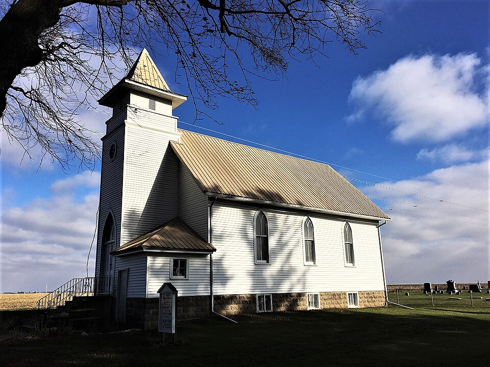
Photograph of Union Presbyterian Church (Stacyville, Iowa)
Photograph by Jon Roanhaus, CC BY-SA 4.0. Via Wikimedia Commons.

Union Presbyterian Church

Listed on the National Register of Historic Places in 1977.

From the record

“Union Presbyterian Church is a historic building located northwest of Stacyville in rural Mitchell County, Iowa, United States. Early settlers to the area of German descent established the Presbyterian congregation in the late 1850s.”

Wikipedia article Union Presbyterian Church (Stacyville, Iowa), CC BY-SA 4.0.

One of 12 National Register listings published here for Mitchell County · listed in 1977 · category: Building.

Sources: the Wikipedia article · the case file at the National Archives · the National Register database, National Park Service · the Wikipedia article

The listing

  • What is counted as historic. The nomination lists 1 building as contributing to the listing.
  • Address. NW of Stacyville, Stacyville, 50476
  • When was it listed? April 1977
  • Category. building
  • Township. Union township
  • National Register reference number. 77000543 - the number the National Park Service assigned this property when it was listed, and the key its nomination file is catalogued under at the National Archives.

Fires near this property

3 since 2011

Regional context, not property-specific evidence. The federal wildfire occurrence database lists 3 fires within 5 miles of Union Presbyterian Church between 2011 and 2020, burning about 95 acres in total. None started naturally. None was recorded as arson. Distance is straight-line from the map coordinates, so a fire counted here may appear on a neighbouring settlement's page as well.

Reported cause Fires
Smoking1
Debris and open burning1
Missing data/not specified/undetermined1

The most recent of them, most recent first, with the day each was reported and the service that recorded it.

DateCause SizeReported by Name on the report
25 April 2020Smokingunder an acreIowa Department of Natural Resourcesnot named
25 April 2020Debris and open burning15 acresIowa Department of Natural Resourcesnot named
6 October 2011Missing data/not specified/undetermined80 acresIowa Department of Natural Resources4903 LANCER AVE., IA

Every fire recorded in Mitchell County

Mines and quarries near this property

3 within 5 miles

Regional context, not property-specific evidence. The federal mineral resources record lists 3 workings within 5 miles of Union Presbyterian Church: 3 past producers. None of them still produces. What was taken out: Sand and Gravel, Construction. Distance is straight-line from the map coordinates, so a quarry counted here may appear on a neighbouring settlement's page as well.

Where SiteCommodity StatusRecorded
UnknownSand and Gravel, ConstructionPast Producer

Every working recorded in Mitchell County

Storms near this property

25 since 1994

Regional context, not property-specific evidence. The National Weather Service names Stacyville, the town this property stands in, in 25 storm reports between 1994 and 2023: 10 hail, 9 thunderstorm wind, 3 tornado, 2 flash flood. No death or injury is recorded in these reports. Each account below is quoted exactly as the forecast office filed it, from the NOAA Storm Events Database, and each date opens the federal record of that event.

WhenEvent Place namedHarm What the report says
July 1994Tornado (F1)Stacyville$500,000no account filed
June 2015Flash FloodStacyville$200,000Locally heavy rains caused the Little Cedar River to rapidly come out of its banks and wash out 480th Street between Monument and Ocean Avenues north of Stacyville.
August 2016Flash FloodStacyville$50,000Runoff from heavy rain caused flooding to occur along Watsons Creek. The flood waters went over Addison Road north of Riceville. Flooding also occurred along the Little Cedar River in the vicinity of Stacyville. Sandbagging operations were performed northwest of Osage in an effort to protect residences from flooding along Sugar Creek.
September 2011Thunderstorm WindStacyville$50,000Numerous trees were blown over, a shed was destroyed, a barn roof damaged and wind turbine blades bent in or near Stacyville.
October 1994Thunderstorm WindStacyville$25,000The seasons first strongly dynamic weather system moved through the central U.S. The surface low formed over the Rockies and advanced across the plains into South Dakota by the late afternoon hours of the 6th. A cold front arched southeast and south of the low across central South Dakota into eastern Nebraska during the late afternoon hours. During the afternoon hours, the middle level dry slot raced north across Kansas, eastern Nebraska, into South Dakota. The surface showed an unstable weather situation. To the east of the cold front, which was actually more a dry line than a cold front, temperatures reached the upper 70s to lower 80s, with dew point temperatures in the lower to middle 60s. Dew point temperatures briefly reach 70 at a few locations during the early evening hours. Behind the dry line, dew point temperatures dropped to the upper 30s and 40s, with a few upper 20s in under the core of the dry slot. Directional sheer was weak, however a strong speed sheer existed. Lifted indices were around -5° C with a nearly 80 kt wind speed in the middle levels. Helicity values increased to around 350 M2/S2 in the pre-storm environment. A line of thunderstorms fired up during the mid to late afternoon hours. The storms quickly became severe as they moved into western Iowa. The hardest hit area was the west central counties where many areas were pelted with large hail. Monona and Crawford Counties were especially hard hit as a series of severe storms moved northeast along the main line of storms. There were numerous reports of golf ball size hail. One storm produced baseball size hail as it passed over the Ute area of Monona County. Baseball size hail also fell a short time later east of Soldier. WSR-88D radar VIL values with this storm were in the 60-65 Kg/M-2 range with the storm. A deep meso circulation was detected over northern Shelby and southern Crawford Counties with one of the storms. A tornado warning was issued. A funnel cloud was reported east of Defiance in Shelby County. It became a tornado briefly south of Manilla near the Shelby/Crawford County line. It passed through fields, causing some crop damage. The tornado dissipated with only a funnel cloud remaining as it passed over Manilla. A short time earlier, these storms produced golf ball size hail southeast of Earling in Shelby County. One farmstead reported 5 windows being broken out by the hail. Siding on the house was also damaged. The storms weakened as the moved east during the early evening. As the line advanced, a weak bow echo formed along the line. This bow echo produced gusty winds of 55 to 60 MPH as it passed over Webster, Boone, Wright, and Winnebago Counties. Damage was minor, however many trees were downed. The roof of one building was blown off and strewn across a field near Gowrie in Webster County. Part of a roof was torn off of a shed at Forest City in Winnebago County. The roof was removed from another farm building on a farmstead near Stacyville in Mitchell County. Damage was also reported west of Pilot Mound and north of Ogden in Boone County. High winds destroyed a 60 X 100 foot farm building on a farm north of Ogden. Damage on that farm was close to $50,000. The storms continued east but weakened slightly. Winds of 40 to 55 MPH were common, however the storms remained below severe levels through the rest of the night.
July 2000Thunderstorm WindStacyville$18,000no account filed
March 2005Tornado (F0)Stacyville$15,000no account filed
August 2000HailStacyville$8,500no account filed
July 1997Thunderstorm WindStacyville$5,000no account filed
May 1994HailStacyville$5,000no account filed
June 2020Thunderstorm WindStacyville$2,000Power lines were downed in Stacyville.
July 2019Thunderstorm WindStacyville$2,000Trees were blown down in Stacyville.
June 2017Thunderstorm WindStacyville$2,000Trees were blown down in Stacyville. One of these landed across a road by Riverside Park.
September 2005HailStacyville$1,000no account filed
May 2000Thunderstorm WindStacyville$750no account filed
May 2000Thunderstorm WindStacyville$500no account filed
March 2023HailStacyville-Half dollar sized hail was reported near Stacyville.
July 2023HailStacyville-Public reported penny sized hail near Stacyville.
April 2017HailStacyville-Half dollar sized hail fell in Stacyville.
July 2013HailStacyville-Quarter sized hail fell in Stacyville.
April 2013HailStacyville-Quarter sized hail fell in Stacyville.
September 2010FloodStacyville-The Little Cedar River over-topped its banks which caused Riverside Park in Stacyville to flood.
June 2008Tornado (EF0)Stacyville-A brief tornado touched down about 2 to 3 miles northwest of Stacyville, as reported by law enforcement officials and storm spotters. The Stacyville police chief photographed the tornado. There was no damage reported.
July 2013HailStacyville-no account filed
September 2005HailStacyville-no account filed

Every storm recorded in Mitchell County

Map coverage status

No historic map-sheet match is published for this property yet. That does not mean no map exists. This record needs a coordinate-quality review before it can be joined to a sheet boundary. Browse the county's mapped places while that work is pending.

Sources for this property

National Archives recordThe nomination case file for reference 77000543 in Record Group 79.
Wikipedia articleCommunity-written account of this property, licensed CC BY-SA.
Mitchell CountyAll 12 listed properties in this county.

Provenance

  • Listing record. National Park Service National Register of Historic Places, listed-properties dataset, current to 2026-05-22.
  • Map join. Address geocoded through the United States Census geocoder, then tested against the published boundary of every sheet in the USGS Historical Topographic Map Collection.
  • How this page is made. Listing fields come from federal records; map-sheet coverage is a labelled coordinate-to-boundary calculation, not a source-field claim.
  • Wildfire. Short, Karen C. 2022. Spatial wildfire occurrence data for the United States, 1992-2020 [FPA_FOD_20221014]. 6th Edition. Fort Collins, CO: Forest Service Research Data Archive. https://doi.org/10.2737/RDS-2013-0009.6 Collected with United States Government funding and usable without additional permissions or fees.
  • Mines and quarries. USGS Mineral Resources Data System (MRDS) https://mrdata.usgs.gov/mrds/ A work of the United States government, no copyright under 17 U.S.C. 105.
  • Storms. NOAA National Centers for Environmental Information, Storm Events Database https://www.ncei.noaa.gov/stormevents/ A work of the United States government, no copyright under 17 U.S.C. 105. Narratives are quoted verbatim from the National Weather Service report and are not edited or summarised.