 Block
From the record
11 National Register listings published here.
Sources: the National Register database, National Park Service
48 topographic sheets cover 28 settlements here, and 11 properties are on the National Register of Historic Places.
11 National Register listings published here.
Sources: the National Register database, National Park Service
Every property in this county listed on the National Register of Historic Places, with the year it was listed and the federal nomination document.
| Photograph | Property | Type | Listed | Reference |
|---|---|---|---|---|
 | Akron Opera House | building | 2012 | 12000403 |
| Foster Park Historic District | district | 2008 | 08000329 | |
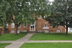 | Le Mars Central High School | building | 1999 | 99000492 |
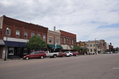 | Le Mars Downtown Commercial Historic District | district | 2012 | 12000908 |
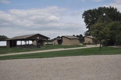 | Le Mars Municipal Park and Golf Course Historic District | district | 2001 | 01000858 |
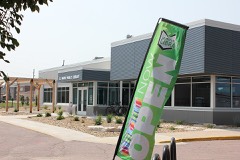 | Le Mars Public Library | building | 1979 | 79000922 |
 | Plymouth County Courthouse | building | 1981 | 81000263 |
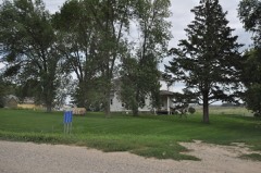 | Reeves Farmstead Historic District | district | 2001 | 00001680 |
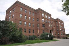 | Sacred Heart Hospital | building | 2010 | 09001303 |
| St. George's Episcopal Church | building | 1976 | 76000797 | |
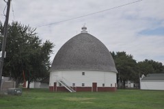 | Tonsfeldt Round Barn | building | 1986 | 86003194 |
Every wildfire the federal occurrence database records inside this county: 18 of them, burning about 508 acres. None started naturally and none was recorded as arson. Each settlement page carries the fires within five miles of it.
| Reported cause | Fires |
|---|---|
| Missing data/not specified/undetermined | 15 |
| Debris and open burning | 2 |
| Equipment and vehicle use | 1 |
The five largest, by the area the report gives. None of them was recorded as arson.
| Date | Cause | Size | Reported by | Name on the report |
|---|---|---|---|---|
| 5 April 2000 | Debris and open burning | 300 acres | Alcester Volunteer Fire Department | PLYMOUTH CO. |
| 30 March 2020 | Missing data/not specified/undetermined | 70 acres | Iowa Department of Natural Resources | not named |
| 29 April 2018 | Debris and open burning | 40 acres | Iowa Department of Natural Resources | not named |
| 17 March 2009 | Missing data/not specified/undetermined | 30 acres | Iowa Department of Natural Resources | not named |
| 1 October 2012 | Equipment and vehicle use | 20 acres | Iowa Department of Natural Resources | not named |
| 17 March 2009 | Missing data/not specified/undetermined | 12 acres | Iowa Department of Natural Resources | not named |
| 7 October 2011 | Missing data/not specified/undetermined | 10 acres | Iowa Department of Natural Resources | C-38 AND SUNSET AVE, IA |
| 26 June 2006 | Missing data/not specified/undetermined | 5.0 acres | Iowa Department of Natural Resources | not named |
Every settlement page carries the fires within five miles of it - see the settlement index below.
The NOAA Storm Events Database holds 693 reports for this county, causing no deaths, 8 injuries and about $21,978,780 in recorded property damage. Each settlement page carries the reports that name it.
| Kind of event | Reports |
|---|---|
| Hail | 277 |
| Thunderstorm Wind | 224 |
| Flood | 110 |
| Tornado | 52 |
| Flash Flood | 22 |
| Funnel Cloud | 4 |
| Heavy Rain | 2 |
| Lightning | 2 |
The most serious of them, by death, then injury, then recorded damage. The accounts are quoted exactly as the forecast office filed them.
| When | Event | Place named | Harm | What the report says |
|---|---|---|---|---|
| June 1967 | Tornado (F3) | not stated | 3 hurt, $250,000 | no account filed |
| June 2010 | Thunderstorm Wind | Akron | 2 hurt, $25,000 | Thunderstorm winds blew over a recreational vehicle, injuring two people. The winds also blew the roof off a building and caused tree damage. |
| June 1963 | Tornado (F2) | not stated | 2 hurt, $25,000 | no account filed |
| August 2001 | Thunderstorm Wind | James | 1 hurt, $50,000 | Thunderstorm winds caused tree damage. A large tree was blown onto a car, causing a minor injury to the occupant. |
| June 1994 | Tornado (F2) | not stated | $5,000,000 | Mostly F1 strength, intermittent path at beginning and end. |
| June 1980 | Tornado (F1) | not stated | $2,500,000 | no account filed |
| July 1978 | Tornado (F2) | not stated | $2,500,000 | no account filed |
| May 1964 | Tornado (F3) | not stated | $2,500,000 | no account filed |
| March 2019 | Flood | James | $2,260,000 | Up to 25 gravel roads were under water across Plymouth County. Other flooding resulted in extensive damage to public infrastructure including numerous county and township roads, culverts, and some bridges. |
| June 2024 | Flood | James | $1,580,000 | Rainfall amounts across Plymouth County from June 20-22 ranged from only a few hundredths across southern areas to around 2 inches across northern areas. Farther north and upstream, 6 to 10 inches of rain fell across portions of southeast South Dakota and northwest Iowa, with locally higher amounts near 12 inches. This rainfall resulted in major to record flooding along the Big Sioux and Floyd Rivers and extensive overland flooding along the adjoining flood plain. ||During peak flooding, areas between the Big Sioux River and Iowa Highway 12 were evacuated. The Willow Creek Campground in Le Mars was also evacuated. There were at least two water rescues, including 14 individuals. County-wide, 47 individual households reported flood damage at an estimated cost of 275 thousand dollars. ||Numerous county roads were impacted by flood waters and closed; the most significant being Iowa Highway 12 and the bridge outside of Akron that crosses the Big Sioux River into South Dakota. The communities of Westfield and Le Mars experienced the greatest impacts with damages to their wastewater treatment plants. Preliminary damage assessments estimate loss to public infrastructure to be 1.3 million dollars.||For additional information on river flooding, please see other flood entries for Plymouth County. |
| June 2014 | Flood | Akron | $500,000 | Repeated heavy rains caused record flooding of the Big Sioux River. Farmland and other lowlands including numerous roads were flooded. Some roads were damaged, and some secondary roads were washed out. Several homes, businesses, and farm buildings were flooded and damaged. A levee breach caused additional flooding in the city of Akron, forcing the evacuation of several residences on the west side of Iowa Highway 12 while the levee was being repaired. The river crested at a record 9.59 feet above flood stage at Akron on June 18th. |
| June 1994 | Thunderstorm Wind | Sioux City | $500,000 | no account filed |
| June 1994 | Thunderstorm Wind | Le Mars | $500,000 | no account filed |
| August 1991 | Tornado (F2) | not stated | $250,000 | no account filed |
| June 1984 | Tornado (F1) | not stated | $250,000 | no account filed |
| July 1980 | Tornado (F1) | not stated | $250,000 | no account filed |
| September 1964 | Tornado (F2) | not stated | $250,000 | no account filed |
| September 1964 | Tornado (F2) | not stated | $250,000 | no account filed |
| April 2017 | Hail | Hinton | $125,000 | Numerous reports of large hail up to half dollar size caused plenty of damage mainly to windows of homes and vehicles. |
| June 2003 | Thunderstorm Wind | Le Mars | $100,000 | Thunderstorm winds caused widespread tree damage, including several trees and numerous large limbs and branches blown down. Tree debris damaged the roofs of at least three homes. The siding of a manufacturing business building was ripped off by the wind. Power lines were downed by wind and falling tree debris, resulting in power outages. |
| September 2002 | Thunderstorm Wind | Le Mars | $100,000 | According to a report from the county extension officer, small hail, accompanied by gusty winds, caused damage to corn and soybean crops. |
| June 1996 | Hail | Hinton | $100,000 | no account filed |
| April 2017 | Hail | Hinton | $75,000 | Hen egg to baseball size hail damaged vehicles and homes. |
| December 2021 | Tornado (EF1) | Kingsley | $50,000 | This tornado formed around 4 miles east-northeast of Moville in Woodbury County and entered Plymouth County around two miles south of Kingsley, just east of the intersection of Knox Avenue and 100th Street. Numerous large trees were snapped as the tornado entered Plymouth County. The tornado continued to travel north-northeast to a location around one mile east of Kingsley where several outbuildings were destroyed and large trees snapped. The tornado then turned to a northerly track as it crossed County Road C66, where it damaged several power poles. The tornado traveled another mile and a half parallel to Roosevelt Avenue before it destroyed a hoop barn and removed the steel roof from a corn crib, with debris scattered a half mile to the north. The tornado dissipated after another quarter mile at 1642CST. The tornado was rated EF1 while in both Woodbury and Plymouth Counties. The average path width in Plymouth County was 50 yards and the maximum estimated wind speed was 105 mph. Property damage costs are a rough estimate. |
| June 2014 | Flood | Akron | $50,000 | Persistent moderate to heavy rain caused flooding of fields and other lowlands, including several roads, homes, and businesses. This flooding lasted for almost two days, and was aggravated locally by additional storms during that time. Some roads were damaged or washed out. |
| June 2014 | Thunderstorm Wind | Le Mars | $50,000 | Thunderstorm winds caused tree damage, including large trees blown down. One tree severely damaged a house when it was blown down onto a roof. |
| June 2010 | Flash Flood | Akron | $50,000 | Heavy rainfall of up to 4 1/2 inches caused widespread flooding of roads, culverts, other low areas, and basements. A few roads were partially or totally washed out. Fields were flooded and crop damage was suspected, but the amout of crop damage was not known. |
| August 2006 | Thunderstorm Wind | Akron | $50,000 | Thunderstorm winds destroyed a barn and a greenhouse. The winds also caused tree damage, including large trees blown down. |
| June 1994 | Hail | Struble | $50,000 | Mostly F1 strength, intermittent path at beginning and end. |
| June 1994 | Hail | Remsen | $50,000 | Mostly F1 strength, intermittent path at beginning and end. |
| June 1994 | Thunderstorm Wind | Remsen | $50,000 | Mostly F1 strength, intermittent path at beginning and end. |
| July 1997 | Thunderstorm Wind | Remsen | $50,000 | no account filed |
| July 1997 | Thunderstorm Wind | Westfield | $50,000 | no account filed |
| July 1994 | Thunderstorm Wind | Le Mars | $50,000 | no account filed |
| July 1994 | Thunderstorm Wind | Le Mars | $50,000 | no account filed |
| June 1994 | Thunderstorm Wind | Remsen | $50,000 | no account filed |
| June 1994 | Thunderstorm Wind | Kingsley | $50,000 | no account filed |
| June 1994 | Thunderstorm Wind | Le Mars | $50,000 | no account filed |
| June 1994 | Thunderstorm Wind | Merrill | $50,000 | no account filed |
| June 1994 | Thunderstorm Wind | Remsen | $50,000 | no account filed |
| June 1994 | Thunderstorm Wind | Remsen | $50,000 | no account filed |
| April 1994 | Thunderstorm Wind | LeMars | $50,000 | no account filed |
| April 1994 | Thunderstorm Wind | LeMars | $50,000 | no account filed |
| June 1994 | Hail | Craig | $50,000 | no account filed |
| June 1994 | Thunderstorm Wind | Le Mars | $50,000 | no account filed |
| June 2021 | Thunderstorm Wind | Akron | $35,000 | Thunderstorm winds destroyed a 100 by 180 foot machine shed. Property damage costs are a rough estimate. |
| December 2021 | Thunderstorm Wind | Kingsley | $35,000 | Thunderstorms winds caused failure of a south-facing door which resulted in uplift of numerous roof panels and removal of insulation. Debris was deposited to the north and northwest of the building amongst several large trees which were snapped. Property damage costs are a rough estimate. |
| December 2021 | Thunderstorm Wind | Kingsley | $30,000 | Thunderstorm winds peeled back large sections of north-facing roof on a hog confinement building. Property damage costs are a rough estimate. |
| December 2021 | Thunderstorm Wind | Kingsley | $30,000 | Thunderstorm winds destroyed two farm outbuildings and flipped a truck on its side. Property damage costs are a rough estimate. |
| June 2011 | Thunderstorm Wind | Craig | $30,000 | Thunderstorm winds caused tree damage, including up to 3 foot diameter trees blown down. Some vehicles were damaged by falling trees. |
| March 2009 | Thunderstorm Wind | Akron | $30,000 | Thunderstorm winds damaged a horse shed and moved it off its foundation. The winds also damaged a barn and caused tree damage, including at least one tree uprooted. |
| August 2003 | Thunderstorm Wind | Remsen | $30,000 | Thunderstorm winds blew part of the roof off a woodworking business. The winds also blew down trees and power lines, resulting in power outages.. |
| June 2001 | Thunderstorm Wind | Le Mars | $30,000 | Thunderstorm winds tore part of the roof and walls from a metal machine shed. Debris damaged a nearby garage. There was also tree and power line damage, and a resulting power outage. |
| June 2001 | Thunderstorm Wind | Kingsley | $30,000 | Thunderstorm winds uprooted large trees, caused other tree damage, and destroyed a machine shed. |
| December 2021 | Thunderstorm Wind | Kingsley | $25,000 | An old barn was destroyed by thunderstorms winds. Property damage costs are a rough estimate. |
| December 2021 | Thunderstorm Wind | Kingsley | $25,000 | Thunderstorm winds caused extensive damage to an outbuilding with an open side toward the southeast. Property damage costs are a rough estimate. |
| December 2021 | Thunderstorm Wind | Kingsley | $25,000 | South-facing door of outbuilding was buckled by thunderstorm winds, which resulted in failure of the east wall of the building. Property damage costs are a rough estimate. |
| August 1991 | Tornado (F2) | not stated | $25,000 | no account filed |
| May 1986 | Tornado (F0) | not stated | $25,000 | no account filed |
| August 1985 | Tornado (F1) | not stated | $25,000 | no account filed |
The Survey's mineral resources record lists 93 workings inside this county. 12 still produce and 81 are closed or unrecorded. Each settlement page carries the workings within five miles of it.
| Commodity | Workings |
|---|---|
| Sand and Gravel, Construction | 91 |
| Limestone, General | 1 |
| Clay | 1 |
The least common of them first, because a county's hundredth gravel pit says nothing its first ten did not.
| Where | Site | Commodity | Status | Recorded |
|---|---|---|---|---|
| Miller Quarry | Clay | Past Producer | ||
| Unknown | Limestone, General | Past Producer | ||
| Akron Pit | Sand and Gravel, Construction | Producer | ||
| Anderson Pit | Sand and Gravel, Construction | Past Producer | ||
| Bainbridge | Sand and Gravel, Construction | Past Producer | ||
| Bedel Pit | Sand and Gravel, Construction | Past Producer | ||
| Corwin Pit | Sand and Gravel, Construction | Past Producer | ||
| E C Lynch Pit | Sand and Gravel, Construction | Past Producer | ||
| E Siebens | Sand and Gravel, Construction | Past Producer | ||
| Everist Akron | Sand and Gravel, Construction | Producer | ||
| Floyd S&G | Sand and Gravel, Construction | Past Producer | ||
| H A Ludwig | Sand and Gravel, Construction | Past Producer | ||
| Hartsell and Evans | Sand and Gravel, Construction | Past Producer | ||
| Higman Ag Lime Quarry | Sand and Gravel, Construction | Producer | ||
| Higman Sand & Gravel Pit | Sand and Gravel, Construction | Producer | ||
| Hogan Const Co | Sand and Gravel, Construction | Producer | ||
| Hoss | Sand and Gravel, Construction | Past Producer | ||
| Howes Pit | Sand and Gravel, Construction | Past Producer | ||
| J J Karly | Sand and Gravel, Construction | Past Producer | ||
| J P Boever | Sand and Gravel, Construction | Past Producer | ||
| Johnson Pit | Sand and Gravel, Construction | Past Producer | ||
| Keith Knapp | Sand and Gravel, Construction | Past Producer | ||
| Kingsley Pit | Sand and Gravel, Construction | Producer | ||
| L and M Sand and Gravel Site No 1 | Sand and Gravel, Construction | Producer | ||
| Laughton | Sand and Gravel, Construction | Past Producer | ||
| Laurel Sand and Gravel | Sand and Gravel, Construction | Past Producer | ||
| Leeds Pit | Sand and Gravel, Construction | Past Producer | ||
| Maudlin Const Co | Sand and Gravel, Construction | Producer | ||
| Maudlin Const Co | Sand and Gravel, Construction | Producer | ||
| Maudlin Const Co | Sand and Gravel, Construction | Producer | ||
| Maudlin Const Co | Sand and Gravel, Construction | Producer | ||
| Mauer Const | Sand and Gravel, Construction | Past Producer | ||
| Mauer Pit | Sand and Gravel, Construction | Past Producer | ||
| Midwest Paving | Sand and Gravel, Construction | Past Producer | ||
| Mrs Hanson | Sand and Gravel, Construction | Past Producer | ||
| Olson Pit | Sand and Gravel, Construction | Past Producer | ||
| Otto Maesker | Sand and Gravel, Construction | Past Producer | ||
| Peterson Const Co | Sand and Gravel, Construction | Past Producer | ||
| Plymouth County Akron Pit | Sand and Gravel, Construction | Producer | ||
| Plymouth County Hwy Dept | Sand and Gravel, Construction | Past Producer | ||
| Remsen | Sand and Gravel, Construction | Past Producer | ||
| Sargent | Sand and Gravel, Construction | Past Producer | ||
| Stroman Pit | Sand and Gravel, Construction | Past Producer | ||
| Struble Pit | Sand and Gravel, Construction | Past Producer | ||
| Thompson | Sand and Gravel, Construction | Past Producer | ||
| Treinen Pit | Sand and Gravel, Construction | Past Producer | ||
| Tritz Co Pit | Sand and Gravel, Construction | Past Producer | ||
| Tritz Pit | Sand and Gravel, Construction | Past Producer | ||
| Unknown | Sand and Gravel, Construction | Past Producer | ||
| Unknown | Sand and Gravel, Construction | Past Producer | ||
| Unknown | Sand and Gravel, Construction | Past Producer | ||
| Unknown | Sand and Gravel, Construction | Past Producer | ||
| Unknown | Sand and Gravel, Construction | Past Producer | ||
| Unknown | Sand and Gravel, Construction | Past Producer | ||
| Unknown | Sand and Gravel, Construction | Past Producer | ||
| Unknown | Sand and Gravel, Construction | Past Producer | ||
| Unknown | Sand and Gravel, Construction | Past Producer | ||
| Unknown | Sand and Gravel, Construction | Past Producer | ||
| Unknown | Sand and Gravel, Construction | Past Producer | ||
| Unknown | Sand and Gravel, Construction | Past Producer | ||
| Unknown | Sand and Gravel, Construction | Past Producer | ||
| Unknown | Sand and Gravel, Construction | Past Producer | ||
| Unknown | Sand and Gravel, Construction | Past Producer | ||
| Unknown | Sand and Gravel, Construction | Past Producer | ||
| Unknown | Sand and Gravel, Construction | Past Producer | ||
| Unknown | Sand and Gravel, Construction | Past Producer | ||
| Unknown | Sand and Gravel, Construction | Past Producer | ||
| Unknown | Sand and Gravel, Construction | Past Producer | ||
| Unknown | Sand and Gravel, Construction | Past Producer | ||
| Unknown | Sand and Gravel, Construction | Past Producer | ||
| Unknown | Sand and Gravel, Construction | Past Producer | ||
| Unknown | Sand and Gravel, Construction | Past Producer | ||
| Unknown | Sand and Gravel, Construction | Past Producer | ||
| Unknown | Sand and Gravel, Construction | Past Producer | ||
| Unknown | Sand and Gravel, Construction | Past Producer | ||
| Unknown | Sand and Gravel, Construction | Past Producer | ||
| Unknown | Sand and Gravel, Construction | Past Producer | ||
| Unknown | Sand and Gravel, Construction | Past Producer | ||
| Unknown | Sand and Gravel, Construction | Past Producer | ||
| Unknown | Sand and Gravel, Construction | Past Producer | ||
| Unknown | Sand and Gravel, Construction | Past Producer | ||
| Unknown | Sand and Gravel, Construction | Past Producer | ||
| Unknown | Sand and Gravel, Construction | Past Producer | ||
| Unknown | Sand and Gravel, Construction | Past Producer | ||
| Unknown | Sand and Gravel, Construction | Past Producer | ||
| Unknown | Sand and Gravel, Construction | Past Producer | ||
| Unknown | Sand and Gravel, Construction | Past Producer | ||
| Unknown | Sand and Gravel, Construction | Past Producer | ||
| Unknown | Sand and Gravel, Construction | Past Producer | ||
| W H Deegan | Sand and Gravel, Construction | Past Producer | ||
| W Strobehn | Sand and Gravel, Construction | Past Producer | ||
| Winterstein | Sand and Gravel, Construction | Past Producer | ||
| Wm Anderson | Sand and Gravel, Construction | Past Producer |
Named settlements recorded in the Geographic Names Information System, each with the topographic sheets covering it. Villages, hamlets and abandoned places alike. Each is shown with the nearest named watercourse or landform and the survey quadrangle it falls on.
Perry township · 51108 · Sioux City North quadrangle
12 sheets, 1955 to 1994
No longer a settlement
Plymouth township · 51038 · On West Branch Floyd River · Union Center NW quadrangle
10 sheets, 1955 to 1986
Sioux township · 51062 · On Deer Creek · Millnerville quadrangle
9 sheets, 1955 to 1986
America township · 51031 · On Willow Creek · Le Mars quadrangle
10 sheets, 1955 to 1986
Stanton township · 51031 · On Plymouth Creek · Union Center NW quadrangle
10 sheets, 1955 to 1986
No longer a settlement
Westfield township · 51062 · On Westfield Creek · Akron quadrangle
18 sheets, 1898 to 1986
Perry township · 51108 · On West Branch Perry Creek · Sioux City North quadrangle
12 sheets, 1955 to 1994
The vanished settlements of Plymouth County: the places named above that are no longer on the map.