 Block
From the record
6 National Register listings published here.
Sources: the National Register database, National Park Service
13 topographic sheets cover 15 settlements here, and 6 properties are on the National Register of Historic Places.
6 National Register listings published here.
Sources: the National Register database, National Park Service
Every property in this county listed on the National Register of Historic Places, with the year it was listed and the federal nomination document.
| Photograph | Property | Type | Listed | Reference |
|---|---|---|---|---|
 | Chicago, Milwaukee, and St. Paul Railroad-Grafton Station | building | 1976 | 76000815 |
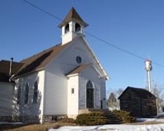 | First Methodist Episcopal Church | building | 2000 | 00000985 |
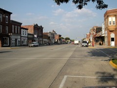 | Northwood Central Avenue Historic District | district | 2006 | 06000857 |
| Old Worth County Courthouse | building | 1981 | 81000276 | |
 | Rhodes Mill | building | 1978 | 78001274 |
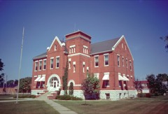 | Worth County Courthouse | building | 1981 | 81000705 |
Every wildfire the federal occurrence database records inside this county: 34 of them, burning about 502 acres. None started naturally and none was recorded as arson. Each settlement page carries the fires within five miles of it.
| Reported cause | Fires |
|---|---|
| Missing data/not specified/undetermined | 19 |
| Debris and open burning | 11 |
| Equipment and vehicle use | 4 |
The five largest, by the area the report gives. None of them was recorded as arson.
| Date | Cause | Size | Reported by | Name on the report |
|---|---|---|---|---|
| 1 November 2012 | Debris and open burning | 200 acres | Iowa Department of Natural Resources | not named |
| 12 May 2006 | Missing data/not specified/undetermined | 120 acres | Iowa Department of Natural Resources | not named |
| 21 April 2009 | Missing data/not specified/undetermined | 30 acres | Iowa Department of Natural Resources | not named |
| 14 April 2016 | Missing data/not specified/undetermined | 20 acres | Iowa Wetland Management District | HANLONTOWN |
| 1 April 2015 | Debris and open burning | 20 acres | Iowa Department of Natural Resources | not named |
| 12 April 2014 | Debris and open burning | 20 acres | Iowa Department of Natural Resources | not named |
| 9 October 2010 | Missing data/not specified/undetermined | 15 acres | Iowa Department of Natural Resources | 3770 BLUEBILL AVE, IOWA |
| 12 May 2019 | Missing data/not specified/undetermined | 12 acres | Iowa Department of Natural Resources | not named |
Every settlement page carries the fires within five miles of it - see the settlement index below.
The NOAA Storm Events Database holds 300 reports for this county, causing no deaths, 6 injuries and about $18,143,500 in recorded property damage. Each settlement page carries the reports that name it.
| Kind of event | Reports |
|---|---|
| Hail | 94 |
| Thunderstorm Wind | 92 |
| Heavy Rain | 47 |
| Flash Flood | 29 |
| Tornado | 24 |
| Flood | 6 |
| Funnel Cloud | 5 |
| Lightning | 3 |
The most serious of them, by death, then injury, then recorded damage. The accounts are quoted exactly as the forecast office filed them.
| When | Event | Place named | Harm | What the report says |
|---|---|---|---|---|
| May 1974 | Tornado (F3) | not stated | 3 hurt, $2,500,000 | no account filed |
| May 2006 | Hail | Northwood | 2 hurt | no account filed |
| April 1967 | Tornado (F4) | not stated | 1 hurt, $2,500,000 | no account filed |
| September 1980 | Tornado (F2) | not stated | $2,500,000 | no account filed |
| July 1971 | Tornado (F3) | not stated | $2,500,000 | no account filed |
| April 1967 | Tornado (F3) | not stated | $2,500,000 | no account filed |
| July 1999 | Flash Flood | Manly | $1,100,000 | no account filed |
| April 2011 | Thunderstorm Wind | Tenold | $300,000 | Large barn destroyed with damage of $250,000-300,000. |
| June 2013 | Flood | Bristol | $250,000 | Portions of Apple Ave washed out or with water over the road at 470th, 490th, and between Apple and HWY 69. |
| July 2013 | Flash Flood | Fertile | $250,000 | Parks Street and West Main Street were extremely flooded. Three to four houses were inundated by water along West Washington St. in Fertile. |
| September 2011 | Thunderstorm Wind | Meltonville | $250,000 | Two separate wind mills were damaged, one had a propeller bent in half and the second had a tip snapped off. Numerous trees and power lines were damaged and corn was flattened. |
| April 1967 | Tornado (F4) | not stated | $250,000 | no account filed |
| June 2013 | Flash Flood | Northwood | $200,000 | Worth County Sheriff's office reported road closures at Ulmus Road between 420th and 400th Rd. Water was flowing over the road from a culvert and 430th between Zinnia Rd west to Yarrow Rd is closed. |
| July 2013 | Flash Flood | Hanlontown | $150,000 | Grouse Ave was closed between 380th and 390th due to water damage from flooding. |
| May 1998 | Tornado (F1) | Joice | $150,000 | no account filed |
| June 2018 | Flash Flood | Manly | $100,000 | Law enforcement reported several county gravel roads closed around the town of Manly, with one road washed out south of Highway 9 on Mallard Ave. |
| June 2013 | Flood | Meltonville | $100,000 | Water over the road on Ulmus Ave between 400th and 420th St. Water also over the road between 430th and 440th between Yarrow and Zinnia Ave. Roads will remain closed through Monday when the gravel can be replaced. |
| June 2013 | Flood | Kensett | $100,000 | Sections of U.S. Highway 65 down to one lane due to flooding. |
| June 2013 | Flash Flood | Manly | $100,000 | Many roads impassable and washed out across the county especially in areas around Manly and areas south of HWY 9 and 410th st south to the county line. |
| June 2008 | Flash Flood | Manly | $100,000 | Flooding was reported near Manly, including water over the road near Highway 9 and Thrush Ave. Four to 6 inches of water was reported over Highway 9 east of Manly. |
| May 2004 | Flash Flood | Countywide | $100,000 | no account filed |
| September 2004 | Flash Flood | Countywide | $100,000 | no account filed |
| July 1999 | Flash Flood | Manly | $100,000 | no account filed |
| September 2001 | Hail | Silver Lake | $80,000 | no account filed |
| July 2017 | Thunderstorm Wind | Hanlontown | $75,000 | County dispatch reported overturned semis along I-35 around mile markers 203, 205, 207, and 208. This is a delayed report and time estimated from radar. |
| June 1998 | Flood | Northwood | $75,000 | no account filed |
| June 1995 | Thunderstorm Wind | Hanlontown | $60,000 | no account filed |
| April 2022 | Tornado (EF1) | Grafton | $50,000 | Tornado developed south of Highway 9 and west of Warbler Avenue and moved northeast. The tornado encountered a farmstead on the south side of Highway 9 producing EF1 damage to trees and an outbuilding. The tornado continued northeast and remained in rural farmland the rest of its path. |
| July 2016 | Thunderstorm Wind | Manly | $50,000 | Delayed report from morning storms. KWWL reported a derailed train due to high winds. Time radar estimated. |
| July 2013 | Flash Flood | Joice | $50,000 | Water was about 6 inches deep and flowing over the main street near Lindon Street in Joice. Total rainfall from 0845 through 1100 was 4.75 inches. |
| July 2011 | Flash Flood | Grafton | $50,000 | A handful of areas with a foot of water flowing over roads through the town of Grafton. |
| June 2008 | Flash Flood | Manly | $50,000 | Water was reported over numerous locations across Worth County, including near 3642 Spruce, and near Highway 9...Yarrow Ave...340th and 350th St. between Highway 65 and Partridge Ave. |
| August 2006 | Thunderstorm Wind | Countywide | $50,000 | no account filed |
| September 2001 | Hail | Silver Lake | $50,000 | no account filed |
| July 2000 | Flash Flood | Countywide | $50,000 | no account filed |
| August 1999 | Tornado (F2) | Joice | $50,000 | no account filed |
| May 1998 | Thunderstorm Wind | Northwood | $50,000 | no account filed |
| July 1994 | Thunderstorm Wind | Northwood | $50,000 | no account filed |
| July 1994 | Hail | Northwood | $50,000 | no account filed |
| May 1994 | Hail | Northwood | $50,000 | no account filed |
| May 1998 | Thunderstorm Wind | Hanlontown | $40,000 | no account filed |
| July 2016 | Thunderstorm Wind | Northwood | $30,000 | Iowa DOT reported Highway 65 blocked in both directions due to downed power lines. Time radar estimated. |
| May 2024 | Thunderstorm Wind | Hanlontown | $25,000 | Public reported damage to grain bins and trees. |
| July 2017 | Thunderstorm Wind | Northwood | $25,000 | County dispatch reported a transformer blown, power lines and power poles down, and tree damage. This is a delayed report and time estimated from radar. |
| July 2017 | Thunderstorm Wind | Hanlontown | $25,000 | Emergency manager reports semis blown over on I-35 near Highway 9. This is a delayed report and time estimated from radar. |
| July 2011 | Thunderstorm Wind | Northwood | $25,000 | Numerous trees down on power lines. |
| April 2011 | Thunderstorm Wind | Fertile | $25,000 | A grain bin was blown over with power lines also downed. |
| July 2009 | Thunderstorm Wind | Manly | $25,000 | Worth County EM reports widespread damage around Manly with trees and branches down and corn flattened to the ground. |
| June 2008 | Flash Flood | Northwood | $25,000 | Street flooding was reported in the area. |
| August 1965 | Tornado (F1) | not stated | $25,000 | no account filed |
| August 1964 | Tornado (F2) | not stated | $25,000 | no account filed |
| August 1964 | Tornado (F2) | not stated | $25,000 | no account filed |
| July 2017 | Thunderstorm Wind | Kensett | $20,000 | Law enforcement reported a tree blown down on a house in Kensett. This is a delayed report and time estimated from radar. |
| July 2016 | Thunderstorm Wind | Tenold | $20,000 | Emergency Manager reported a camper overturned due to high winds. Time radar estimated. |
| June 2013 | Thunderstorm Wind | Kensett | $20,000 | Fifteen power poles down at 400th and Orchid. Several trees and power poles down across the county. |
| September 2001 | Hail | Northwood | $20,000 | no account filed |
| May 2000 | Hail | Joice | $20,000 | no account filed |
| June 1998 | Lightning | Kensett | $20,000 | no account filed |
| July 2017 | Thunderstorm Wind | Hanlontown | $15,000 | Emergency manager reported trees uprooted and a grain bin blown down in Hanlontown. This is a delayed report and time estimated by radar. |
| October 2006 | Hail | Northwood | $15,000 | no account filed |
The Survey's mineral resources record lists 34 workings inside this county. 16 still produce and 18 are closed or unrecorded. Each settlement page carries the workings within five miles of it.
| Commodity | Workings |
|---|---|
| Sand and Gravel, Construction | 24 |
| Stone, Crushed/Broken | 10 |
The least common of them first, because a county's hundredth gravel pit says nothing its first ten did not.
| Where | Site | Commodity | Status | Recorded |
|---|---|---|---|---|
| Fertile Quarry & Mill | Stone, Crushed/Broken | Producer | ||
| Hanson | Stone, Crushed/Broken | Producer | ||
| Harris Quarry | Stone, Crushed/Broken | Producer | ||
| Jaspers Pit | Stone, Crushed/Broken | Producer | ||
| Kensett Quarry | Stone, Crushed/Broken | Unknown | ||
| Kuennen Quarry | Stone, Crushed/Broken | Producer | ||
| Northwood Quarry | Stone, Crushed/Broken | Producer | ||
| Randall Quarry | Stone, Crushed/Broken | Producer | ||
| Shell Rock Quarry | Stone, Crushed/Broken | Past Producer | ||
| Stevens Quarry | Stone, Crushed/Broken | Producer | ||
| Aase Pit and Plant | Sand and Gravel, Construction | Producer | ||
| Brakke Pit | Sand and Gravel, Construction | Producer | ||
| Clark Pit | Sand and Gravel, Construction | Past Producer | ||
| Fertile Sand Plant | Sand and Gravel, Construction | Producer | ||
| Hanlontown Pit | Sand and Gravel, Construction | Past Producer | ||
| Kensett Pit | Sand and Gravel, Construction | Past Producer | ||
| Knutson Pit | Sand and Gravel, Construction | Producer | ||
| Lucken Pit | Sand and Gravel, Construction | Producer | ||
| Moretz Pit | Sand and Gravel, Construction | Producer | ||
| Prestholt | Sand and Gravel, Construction | Producer | ||
| Unknown | Sand and Gravel, Construction | Past Producer | ||
| Unknown | Sand and Gravel, Construction | Past Producer | ||
| Unknown | Sand and Gravel, Construction | Past Producer | ||
| Unknown | Sand and Gravel, Construction | Past Producer | ||
| Unknown | Sand and Gravel, Construction | Past Producer | ||
| Unknown | Sand and Gravel, Construction | Past Producer | ||
| Unknown | Sand and Gravel, Construction | Unknown | ||
| Unknown | Sand and Gravel, Construction | Past Producer | ||
| Unknown | Sand and Gravel, Construction | Past Producer | ||
| Unknown | Sand and Gravel, Construction | Past Producer | ||
| Unknown | Sand and Gravel, Construction | Past Producer | ||
| Williams Pit | Sand and Gravel, Construction | Past Producer | ||
| Winter Pit | Sand and Gravel, Construction | Past Producer | ||
| Worth County Pits | Sand and Gravel, Construction | Producer |
Named settlements recorded in the Geographic Names Information System, each with the topographic sheets covering it. Villages, hamlets and abandoned places alike. Each is shown with the nearest named watercourse or landform and the survey quadrangle it falls on.