 Block
From the record
9 National Register listings published here.
Sources: the National Register database, National Park Service
17 topographic sheets cover 16 settlements here, and 9 properties are on the National Register of Historic Places.
9 National Register listings published here.
Sources: the National Register database, National Park Service
Every property in this county listed on the National Register of Historic Places, with the year it was listed and the federal nomination document.
| Photograph | Property | Type | Listed | Reference |
|---|---|---|---|---|
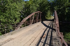 | Boone River Bridge | structure | 1998 | 98000457 |
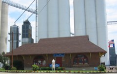 | Burlington, Cedar Rapids & Northern Passenger Depot-Dows | building | 1993 | 92001744 |
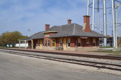 | Burlington, Cedar Rapids and Northern Railroad Passenger Station | building | 1988 | 88000926 |
| Cornelia Lake Bridge | structure | 1998 | 98000455 | |
 | Eagle Grove Public Library | building | 1977 | 77000569 |
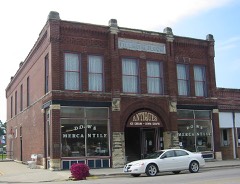 | Fillmore Block | building | 1998 | 98001323 |
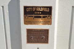 | Goldfield Bridge | structure | 1998 | 98000456 |
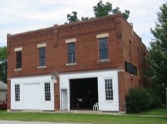 | Quasdorf Blacksmith and Wagon Shop | building | 1994 | 93001545 |
 | Wright County Courthouse | building | 1981 | 81000277 |
Every wildfire the federal occurrence database records inside this county: 12 of them, burning about 132 acres. None started naturally and none was recorded as arson. Each settlement page carries the fires within five miles of it.
| Reported cause | Fires |
|---|---|
| Missing data/not specified/undetermined | 11 |
| Equipment and vehicle use | 1 |
The five largest, by the area the report gives. None of them was recorded as arson.
| Date | Cause | Size | Reported by | Name on the report |
|---|---|---|---|---|
| 28 March 2009 | Missing data/not specified/undetermined | 40 acres | Iowa Department of Natural Resources | not named |
| 22 April 2009 | Missing data/not specified/undetermined | 35 acres | Iowa Department of Natural Resources | not named |
| 11 April 2009 | Missing data/not specified/undetermined | 20 acres | Iowa Department of Natural Resources | not named |
| 29 March 2010 | Missing data/not specified/undetermined | 10 acres | Iowa Department of Natural Resources | 1686 285TH STREET, IOWA |
| 11 April 2009 | Missing data/not specified/undetermined | 10 acres | Iowa Department of Natural Resources | not named |
| 25 October 2006 | Missing data/not specified/undetermined | 5.0 acres | Iowa Department of Natural Resources | not named |
| 19 April 2009 | Missing data/not specified/undetermined | 5.0 acres | Iowa Department of Natural Resources | not named |
| 17 March 2012 | Missing data/not specified/undetermined | 4.0 acres | Iowa Department of Natural Resources | not named |
Every settlement page carries the fires within five miles of it - see the settlement index below.
The NOAA Storm Events Database holds 351 reports for this county, causing 7 deaths, 173 injuries and about $30,774,750 in recorded property damage. Each settlement page carries the reports that name it.
| Kind of event | Reports |
|---|---|
| Thunderstorm Wind | 136 |
| Hail | 96 |
| Tornado | 38 |
| Heavy Rain | 31 |
| Flash Flood | 24 |
| Flood | 17 |
| Funnel Cloud | 7 |
| Lightning | 2 |
The most serious of them, by death, then injury, then recorded damage. The accounts are quoted exactly as the forecast office filed them.
| When | Event | Place named | Harm | What the report says |
|---|---|---|---|---|
| October 1966 | Tornado (F5) | not stated | 6 killed, 172 hurt, $25,000,000 | no account filed |
| June 2008 | Flash Flood | Eagle Grove Arpt | 1 killed, $25,000 | Street flooding in Eagle Grove with some streets closed. |
| May 1998 | Lightning | Belmond | 1 hurt, $2,000 | no account filed |
| June 2013 | Tornado (EF3) | Olaf | $500,000 | EF3 tornado with a winds of 155 MPH. Damaged farmsteads and businesses with most damage on the north edge of Belmond near the intersection of Highway 65 and County Road C20. |
| June 2010 | Flash Flood | Florence | $500,000 | Street flooding in Clarion. Town still without power. EM reports nearly every town in Wright County has street flooding. |
| December 2021 | Thunderstorm Wind | Belmond | $250,000 | Emergency manager reported 3 to 4 outbuildings completely destroyed near Belmond. Time estimated from radar. |
| June 1979 | Tornado (F1) | not stated | $250,000 | no account filed |
| June 2010 | Flood | Belmond | $200,000 | no account filed |
| December 2021 | Tornado (EF2) | Galt | $150,000 | This tornado develop several miles southwest of Galt producing damage to a couple different confinement operations. Buildings were completely destroyed at one operation along 250th Street producing EF2 damage. The tornado continued northeast with additional damage to outbuildings before dissipating to the west southwest of Rowan. |
| June 2001 | Hail | Belmond | $150,000 | no account filed |
| September 2018 | Flood | Clarion Arpt | $100,000 | Emergency manager reported several road closures due to water over the roadways. |
| September 2018 | Flood | Cornelia | $100,000 | The Iowa River at Rowan crested at 14.41 feet on 23 September 2018 at 0445 UTC. |
| June 2015 | Thunderstorm Wind | Galt | $100,000 | Emergency Manager reported prefabricated house moved off its foundation and significant hog facility damage done at the same location. Time radar estimated. |
| June 2015 | Thunderstorm Wind | Solberg | $100,000 | Emergency Manager reported significant damage to chicken facilities just north of intersection of 250th and Quincy Ave. Time radar estimated. |
| June 2010 | Flood | Holmes | $100,000 | Highway 3 west of Clarion was closed due to high water over the road from Eagle Creek. Some blacktop and gravel roads throughout the county were closed by water covering the roads. |
| June 2010 | Flash Flood | Holmes | $100,000 | Highway 3 closed by flooding. |
| August 2007 | Flash Flood | Florence | $100,000 | Water was reported in basements due to heavy rains. Flooding was also reported in Goldfield and Eagle Grove. |
| April 2008 | Flood | Florence | $100,000 | no account filed |
| June 2007 | Flash Flood | Clarion | $100,000 | no account filed |
| June 1997 | Flash Flood | Rowan | $100,000 | no account filed |
| July 2000 | Flash Flood | Countywide | $75,000 | no account filed |
| June 1998 | Flood | Clarion | $75,000 | no account filed |
| May 1995 | Hail | Dows | $75,000 | no account filed |
| May 2020 | Tornado (EF1) | Woolstock | $70,000 | A tornado developed just north of the Wright County/Hamilton County line and moved north. Significant tree damage occurred along the path and a large machine shed was destroyed. |
| July 2016 | Thunderstorm Wind | Eagle Grove | $50,000 | Trained spotter reported several large trees down, either split in half or completely toppled over, throughout the town of Eagle Grove. One large tree fell on a house along West Broadway, along with several trees covering the street near the intersection of West Broadway and Fort. |
| September 2016 | Flood | Belmond | $50,000 | Iowa DOT reported US Highway 69 closed near Belmond due to flooding. Detour in place. |
| September 2016 | Flash Flood | Rowan | $50,000 | Law enforcement reported numerous secondary roads with water over topping them, with some now closed. Issues are mostly across northern Wright County, but scattered about elsewhere too. |
| June 2015 | Thunderstorm Wind | Eagle Grove | $50,000 | Trained spotter reported numerous large trees down including a one to two foot diameter tree on a house. |
| June 2015 | Thunderstorm Wind | Galt | $50,000 | Emergency Manager reported Highway 69 closed from 250th to 260th Ave due to downed power lines and power poles. |
| August 2015 | Thunderstorm Wind | Woolstock | $50,000 | Public reported numerous 6 inch branches and a few trees down in town along with a number of light poles snapped. A few roads in town were also closed. Delayed report, time estimated via radar. |
| June 2014 | Thunderstorm Wind | Palsville | $50,000 | Swath of wind damage in far eastern Wright County in which a tornado was embedded. Damaged trees and a grain bin. |
| June 2010 | Flash Flood | Clarion | $50,000 | Highway 69 was under water 4 miles south of Belmond and Highway 3 was under water 1 mile west of Clarion. |
| June 2008 | Flash Flood | Eagle Grove | $50,000 | Water up to houses and flowing into basements. |
| July 2013 | Hail | Clarion | $50,000 | no account filed |
| May 2013 | Flood | Belmond | $50,000 | no account filed |
| March 2010 | Flood | Belmond | $50,000 | no account filed |
| June 2005 | Flash Flood | Countywide | $50,000 | no account filed |
| May 2004 | Flash Flood | Eagle Grove | $50,000 | no account filed |
| June 2002 | Hail | Eagle Grove | $50,000 | no account filed |
| May 1998 | Tornado (F1) | Eagle Grove | $50,000 | no account filed |
| June 1998 | Flood | Clarion | $50,000 | no account filed |
| June 1997 | Thunderstorm Wind | Dows | $50,000 | no account filed |
| June 2025 | Thunderstorm Wind | Dows | $45,000 | Significant damage to an outbuilding on a farm near Dows. Images found via social media. |
| June 2014 | Thunderstorm Wind | Eagle Grove | $40,000 | Multiple locations in SW Wright County sustained light to moderate tree damage. Light roof damage to several farm houses. |
| June 2014 | Thunderstorm Wind | Holmes | $40,000 | Half of a roof was blown off of a house in Holmes. Many five inch diameter tree branches down in the area with power lines down as well. |
| August 2007 | Flash Flood | Eagle Grove | $30,000 | Law Enforcement reported basement flooding in two residences. The occupants were rescued from a stalled car in 3 feet of water at Lucas and northeast 2nd Street. One to two feet of water was reported at the 700 block of north Iowa Ave in Eagle Grove. Street flooding was reported and street barricades were placed. |
| March 2005 | Tornado (F1) | Dows | $30,000 | Tornado destroyed a garage and ripped the roof off of a barn northwest of Dows. |
| June 1999 | Thunderstorm Wind | Eagle Grove | $30,000 | no account filed |
| July 1998 | Thunderstorm Wind | Belmond | $30,000 | no account filed |
| September 2018 | Flood | Belmond | $25,000 | Law enforcement reported flooding in portions of the county with some roads impassible. Many roads have standing water and larger creeks and streams are rising out of their banks. |
| July 2016 | Thunderstorm Wind | Goldfield | $25,000 | Law Enforcement reported multiple power lines and large trees down from Goldfield to Eagle Grove. |
| June 2015 | Thunderstorm Wind | Clarion | $25,000 | Public reported power lines and tree limbs down throughout town. Report via WOI and time radar estimated. |
| June 2014 | Thunderstorm Wind | Clarion | $25,000 | A four foot tree was down on a house and car in the 1000 block of S. Main St. |
| August 2014 | Tornado (EF0) | Galt | $25,000 | This tornado moved into Wright county from Hamilton county. The tornado continued to travel east northeast in rural areas of southern Wright county producing mainly crop damage. It did destroyed two empty grain bins before dissipating. The tornado was found and rated using high resolution satellite imagery. |
| May 2008 | Flash Flood | Clarion Arpt | $25,000 | A portion of County Road R38 had water over the road near the intersection of R38 and 280th St. There were also reports of water over County Road C54. Flooding was also reported near the intersection of 290th and Madison, and also at 200th and Calhoun. |
| June 2008 | Flash Flood | Goldfield | $25,000 | Eagle Creek flooded and caused water to run over Highway C54 east of Eagle Grove. |
| June 2007 | Hail | Florence | $25,000 | no account filed |
| September 2000 | Hail | Eagle Grove | $25,000 | no account filed |
| August 1998 | Hail | Clarion | $25,000 | no account filed |
| May 1991 | Tornado (F2) | not stated | $25,000 | no account filed |
The Survey's mineral resources record lists 42 workings inside this county. 9 still produce and 33 are closed or unrecorded. Each settlement page carries the workings within five miles of it.
| Commodity | Workings |
|---|---|
| Sand and Gravel, Construction | 42 |
The least common of them first, because a county's hundredth gravel pit says nothing its first ten did not.
| Where | Site | Commodity | Status | Recorded |
|---|---|---|---|---|
| Aldrich | Sand and Gravel, Construction | Producer | ||
| Amosson Pit | Sand and Gravel, Construction | Past Producer | ||
| Augustine Pit | Sand and Gravel, Construction | Producer | ||
| Clarion Pit | Sand and Gravel, Construction | Past Producer | ||
| Denger Pit | Sand and Gravel, Construction | Past Producer | ||
| Dorr | Sand and Gravel, Construction | Producer | ||
| Dows Pit | Sand and Gravel, Construction | Past Producer | ||
| Echhoff Pit | Sand and Gravel, Construction | Producer | ||
| Goldfield Pit | Sand and Gravel, Construction | Past Producer | ||
| Hunt Pit | Sand and Gravel, Construction | Past Producer | ||
| Lesher Pit | Sand and Gravel, Construction | Producer | ||
| Marlowe Oakland Pit | Sand and Gravel, Construction | Past Producer | ||
| Mcnulty Pit | Sand and Gravel, Construction | Past Producer | ||
| Meineke Pit | Sand and Gravel, Construction | Past Producer | ||
| Nelson Pit and Plant | Sand and Gravel, Construction | Producer | ||
| Nielsen Pit | Sand and Gravel, Construction | Producer | ||
| Patterson Pit | Sand and Gravel, Construction | Past Producer | ||
| Roosevelt | Sand and Gravel, Construction | Past Producer | ||
| Unknown | Sand and Gravel, Construction | Past Producer | ||
| Unknown | Sand and Gravel, Construction | Unknown | ||
| Unknown | Sand and Gravel, Construction | Past Producer | ||
| Unknown | Sand and Gravel, Construction | Producer | ||
| Unknown | Sand and Gravel, Construction | Past Producer | ||
| Unknown | Sand and Gravel, Construction | Past Producer | ||
| Unknown | Sand and Gravel, Construction | Past Producer | ||
| Unknown | Sand and Gravel, Construction | Past Producer | ||
| Unknown | Sand and Gravel, Construction | Past Producer | ||
| Unknown | Sand and Gravel, Construction | Past Producer | ||
| Unknown | Sand and Gravel, Construction | Past Producer | ||
| Unknown | Sand and Gravel, Construction | Past Producer | ||
| Unknown | Sand and Gravel, Construction | Past Producer | ||
| Unknown | Sand and Gravel, Construction | Past Producer | ||
| Unknown | Sand and Gravel, Construction | Past Producer | ||
| Unknown | Sand and Gravel, Construction | Past Producer | ||
| Unknown | Sand and Gravel, Construction | Past Producer | ||
| Unknown | Sand and Gravel, Construction | Past Producer | ||
| Unknown | Sand and Gravel, Construction | Past Producer | ||
| Unknown | Sand and Gravel, Construction | Past Producer | ||
| Unknown | Sand and Gravel, Construction | Past Producer | ||
| Unknown | Sand and Gravel, Construction | Past Producer | ||
| Unknown | Sand and Gravel, Construction | Past Producer | ||
| White Pit | Sand and Gravel, Construction | Producer |
Named settlements recorded in the Geographic Names Information System, each with the topographic sheets covering it. Villages, hamlets and abandoned places alike. Each is shown with the nearest named watercourse or landform and the survey quadrangle it falls on.
Pleasant township · 50421 · On East Branch Iowa River · Belmond quadrangle
9 sheets, 1954 to 1984
Liberty township · 50542 · On Buttermilk Creek · Eagle Grove quadrangle
9 sheets, 1954 to 1984
The vanished settlements of Wright County: the places named above that are no longer on the map.