 Block
Dahlonega, Iowa
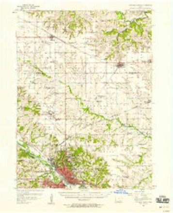
9 topographic sheets cover this place, the earliest surveyed in 1954 and the latest in 1982. It stands in Dahlonega Township. It lies in ZIP code area 52501. The Survey maps it on the Farson quadrangle.
On record in Dahlonega
Buildings and businesses the archive holds for this place. Each opens its own page, with the source record it came from.
On the National Register within a mile 1 record
The National Register names another town for these. They stand within one mile of this settlement's coordinate.
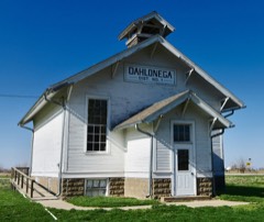 Dahlonega School #1listed 2000 · 0.0 miles away
Topographic sheets covering this place
7 surveys from 9 printed sheetsMatched by testing this settlement's coordinate against the published boundary of every sheet in the United States Geological Survey's historical collection. Each opens the scanned sheet at the Survey.
- 1954 USGS Des Moines quadrangle1:250000, 2 printings
- 1956 USGS Des Moines quadrangle1:250000
- 1956 USGS Farson quadrangle1:24000, 2 printings
- 1956 USGS Ottumwa North quadrangle1:62500
- 1957 USGS Des Moines quadrangle1:250000
- 1969 USGS Des Moines quadrangle1:250000
- 1982 USGS Oskaloosa quadrangle1:100000
Fires near this place
21 since 2002Regional context, not property-specific evidence. The federal wildfire occurrence database lists 21 fires within 5 miles of Dahlonega between 2002 and 2018, burning about 119 acres in total. None started naturally. 1 was recorded as arson. Distance is straight-line from the map coordinates, so a fire counted here may appear on a neighbouring settlement's page as well.
| Reported cause | Fires |
|---|---|
| Missing data/not specified/undetermined | 12 |
| Debris and open burning | 7 |
| Arson/incendiarism | 1 |
| Equipment and vehicle use | 1 |
The most recent of them, most recent first, with the day each was reported and the service that recorded it.
| Date | Cause | Size | Reported by | Name on the report |
|---|---|---|---|---|
| 13 September 2002 | Debris and open burning | under an acre | Iowa State Fire Marshal's Office | not named |
| 4 August 2018 | Debris and open burning | 1.0 acres | Iowa Department of Natural Resources | not named |
| 18 August 2002 | Debris and open burning | under an acre | Iowa State Fire Marshal's Office | not named |
| 11 August 2002 | Missing data/not specified/undetermined | under an acre | Iowa State Fire Marshal's Office | not named |
| 4 July 2002 | Missing data/not specified/undetermined | under an acre | Iowa State Fire Marshal's Office | not named |
| 31 July 2002 | Missing data/not specified/undetermined | under an acre | Iowa State Fire Marshal's Office | not named |
| 2 July 2002 | Missing data/not specified/undetermined | under an acre | Iowa State Fire Marshal's Office | not named |
| 11 July 2018 | Missing data/not specified/undetermined | 1.0 acres | Iowa Department of Natural Resources | not named |
Settlements close enough to share some of these fires:
Mines and quarries near this place
8 within 5 milesRegional context, not property-specific evidence. The federal mineral resources record lists 8 workings within 5 miles of Dahlonega: 7 past producers, 1 producer. 1 still produces. What was taken out: Sand and Gravel, Construction, Clay, Limestone, Dimension, Stone, Crushed/Broken. Distance is straight-line from the map coordinates, so a quarry counted here may appear on a neighbouring settlement's page as well.
| Where | Site | Commodity | Status | Recorded |
|---|---|---|---|---|
| Old City Quarry | Stone, Crushed/Broken | Past Producer | ||
| Bear Creek Quarries | Limestone, Dimension | Past Producer | ||
| Can-Tex Industries Ottumwa Pit | Clay | Producer | ||
| Harrows Branch Quarries | Limestone, Dimension | Past Producer | ||
| Ottumwa Brick and Tile Co. | Clay | Past Producer | ||
| Materials Service Pit | Sand and Gravel, Construction | Past Producer | ||
| Ottumwa Pit | Sand and Gravel, Construction | Past Producer | ||
| Unknown | Sand and Gravel, Construction | Past Producer |
Storms near this place
16 since 2010Regional context, not property-specific evidence. The National Weather Service names Dahlonega in 16 storm reports between 2010 and 2023: 8 heavy rain, 4 thunderstorm wind, 2 hail, 1 flash flood. No death or injury is recorded in these reports. Each account below is quoted exactly as the forecast office filed it, from the NOAA Storm Events Database, and each date opens the federal record of that event.
| When | Event | Place named | Harm | What the report says |
|---|---|---|---|---|
| March 2023 | Tornado (EF2) | Dahlonega | $2,000,000 | Long track tornado began in Wapello County northeast |of Ottumwa then tracked northeast into Keokuk County. |The primary damage in Wapello County consisted of three |homes and one hog confinement facility. The first home |lost the entire roof and one external wall. The first failure |point was likely the wind entering and lifting the garage |which then led to failure of the roof. The home only had |straight nailed connections to the external walls spaced|every 18 inches and less to the roof. An unoccupied |mobile home on the property was not well anchored and |rolled to total destruction. This location was rated 110 mph |and EF-1. Two well anchored hog confinement buildings |were totally destroyed and were rated EF-2. The tornado |then impacted a location with a well built 2 story brick |house. The house suffered some roof and window damage |and a loss of a garage door but sustained little other |damage. Other damage indicators at the site suggested |EF-1 winds. Total destruction of a house occurred just |prior to the tornado exiting the county. This older house |sat unanchored to the concrete block basement. The house |was pushed off the foundation and crumbled. Some trees |near the house and a propane tank were mostly left with |little damage. A larger tree directly next to the house on |the wind side had several large limbs removed. Due to |all of these reasons, the wind at this location has been |rated at 135 mph, or high end EF-2. |
| August 2010 | Flash Flood | Dahlonega | $250,000 | Local law enforcement and trained spotters report water flowing over Highway 149 and North Court Road in the 2600 to 2700 block on the north side of Ottumwa. Water was up to the windows of cars with vehicles stalling and traffic backing up. |
| May 2014 | Thunderstorm Wind | Dahlonega | $50,000 | Wooden barn and carport destroyed with lots of tin spread about. |
| May 2014 | Thunderstorm Wind | Dahlonega | $25,000 | Barn damage was reported. |
| April 2014 | Thunderstorm Wind | Dahlonega | $10,000 | Six to 10 inch tree limb damage and an empty enclosed trailer blown over. |
| May 2014 | Hail | Dahlonega | $3,000 | no account filed |
| July 2014 | Thunderstorm Wind | Dahlonega | $1,000 | Law enforcement reported a power pole downed by thunderstorm winds. |
| June 2021 | Heavy Rain | Dahlonega | - | A trained spotter reported 6.5 inches of rain fell in 12 hours. |
| June 2021 | Heavy Rain | Dahlonega | - | Trained spotter reported 3.50 inches of rain in 24 hours. |
| June 2020 | Heavy Rain | Dahlonega | - | Coop observer recorded 3.03 inches of rainfall over the last 24 hours. |
| May 2019 | Heavy Rain | Dahlonega | - | CoCoRaHS observer recorded heavy rainfall of 2.06 inches over the last 24 hours. |
| August 2018 | Heavy Rain | Dahlonega | - | CoCoRaHS observer recorded heavy rainfall of 3.50 inches over the last 24 hours. |
| August 2018 | Heavy Rain | Dahlonega | - | CoCoRaHS observer recorded heavy rainfall of 2.36 inches over the last 24 hours. |
| April 2017 | Heavy Rain | Dahlonega | - | CoCoRaHS report of 1.47 inches of rain in the past 24 hours. Delayed report. |
| November 2015 | Heavy Rain | Dahlonega | - | CoCoRaHS observer reported heavy rainfall of 2.53 inches over the last 24 hours. |
| April 2010 | Hail | Dahlonega | - | no account filed |
Nearest settlements
The eight closest, with where each one stands in the county. Distances are straight-line, computed from the Geographic Names Information System coordinates.
| Map | Place | Distance | Sheets |
|---|---|---|---|
| Loch Burns | 2.5 miles | 9 | |
| Rutledge | 2.7 miles | 9 | |
| Phillips | 3.0 miles | 9 | |
| Ottumwa | 3.5 miles | 9 | |
| East Ottumwa | 3.7 miles | 9 | |
| Ottumwa Junction | 3.8 miles | 9 | |
| Pickwick | 4.3 miles | 9 | |
| Highland Center | 4.8 miles | 8 |
Provenance
This settlement is recorded in the Geographic Names Information System as feature 455767. The sheet list is computed by point-in-boundary test against the United States Geological Survey's historical topographic inventory. Both are works of the United States government and carry no copyright under 17 U.S.C. 105.
Wildfire. Short, Karen C. 2022. Spatial wildfire occurrence data for the United States, 1992-2020 [FPA_FOD_20221014]. 6th Edition. Fort Collins, CO: Forest Service Research Data Archive. https://doi.org/10.2737/RDS-2013-0009.6 Collected with United States Government funding and usable without additional permissions or fees.
Mines and quarries. USGS Mineral Resources Data System (MRDS) https://mrdata.usgs.gov/mrds/ A work of the United States government, no copyright under 17 U.S.C. 105.
Storms. NOAA National Centers for Environmental Information, Storm Events Database https://www.ncei.noaa.gov/stormevents/ A work of the United States government, no copyright under 17 U.S.C. 105. Narratives are quoted verbatim from the National Weather Service report and are not edited or summarised.