BlockBefore
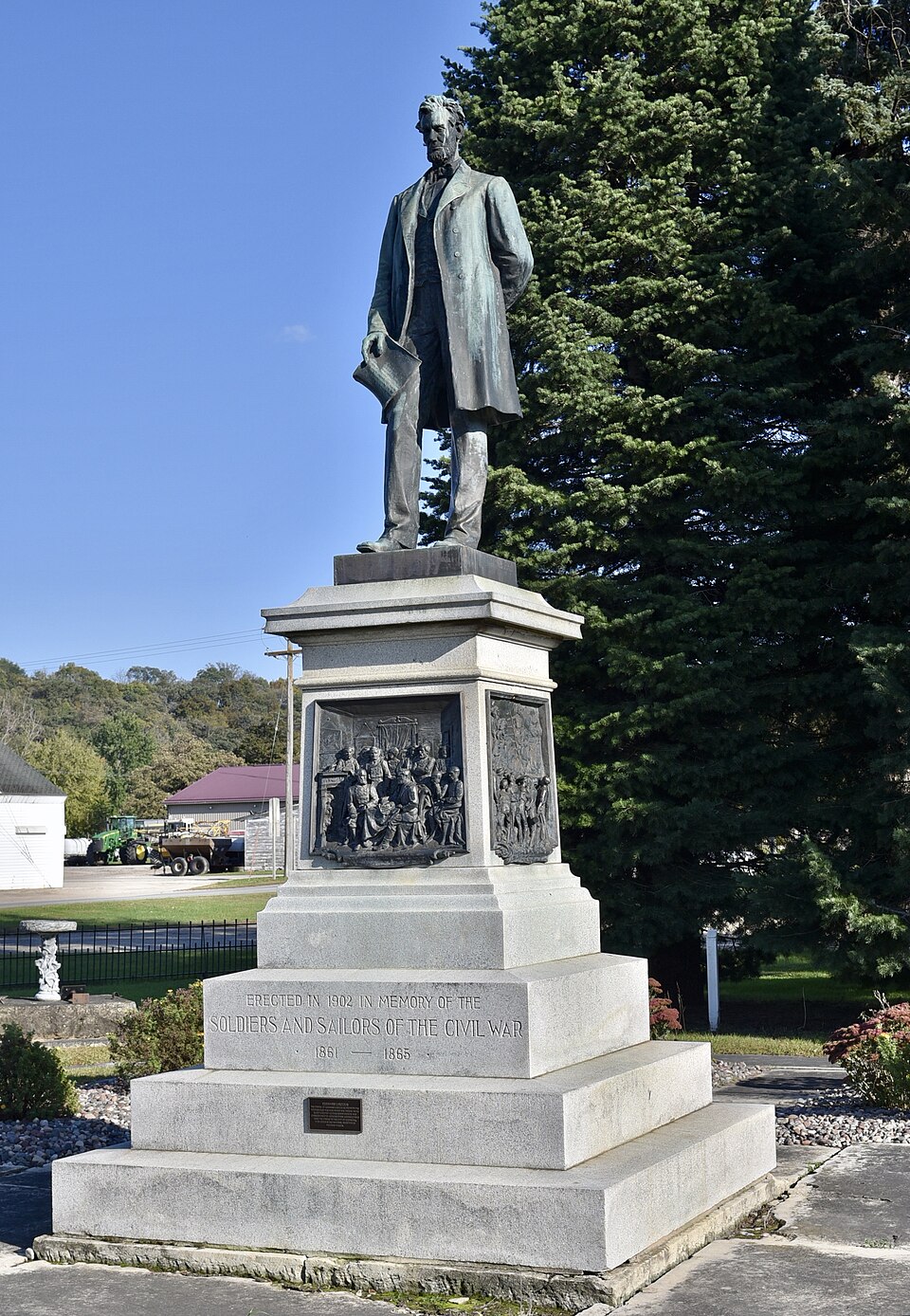
Photograph of Abraham Lincoln Statue and Park
Photograph by Jim Roberts, CC BY-SA 4.0. Via Wikimedia Commons.

Abraham Lincoln Statue and Park

Built in 1902. Listed on the National Register of Historic Places in 2000.

From the record

“Abraham Lincoln Statue and Park is a historic property located in Clermont, Iowa, United States. The statue was erected in 1902, and the property was listed on the National Register of Historic Places in 2000.”

Wikipedia article Abraham Lincoln Statue and Park, CC BY-SA 4.0.

One of 29 National Register listings published here for Fayette County · listed in 2000 · category: Object · built in 1902.

Sources: the Wikipedia article · the case file at the National Archives · the National Register database, National Park Service
The listing

  • What is counted as historic. The nomination lists 1 site, 1 structure, 1 object as contributing to the listing.
  • Address. Jct. of Mill and Stone, Clermont, 52135
  • When was it listed? October 2000
  • Category. object
  • Township. Clermont township
  • When was it built? 1902
  • National Register reference number. 00001197 - the number the National Park Service assigned this property when it was listed, and the key its nomination file is catalogued under at the National Archives.

Fires near this property

4 since 2009

Regional context, not property-specific evidence. The federal wildfire occurrence database lists 4 fires within 5 miles of Abraham Lincoln Statue and Park between 2009 and 2014, burning about 3 acres in total. None started naturally. None was recorded as arson. Distance is straight-line from the map coordinates, so a fire counted here may appear on a neighbouring settlement's page as well.

Reported cause Fires
Missing data/not specified/undetermined4

The most recent of them, most recent first, with the day each was reported and the service that recorded it.

DateCause SizeReported by Name on the report
18 April 2014Missing data/not specified/undeterminedunder an acreIowa Department of Natural Resourcesnot named
15 April 2009Missing data/not specified/undeterminedunder an acreIowa Department of Natural Resourcesnot named
11 April 2009Missing data/not specified/undetermined1.0 acresIowa Department of Natural Resourcesnot named
22 March 2010Missing data/not specified/undeterminedunder an acreIowa Department of Natural Resources7257 GOLDEN ROAD ELGIN, IA 52141, IOWA

Every fire recorded in Fayette County

Mines and quarries near this property

10 of 13 shown

Regional context, not property-specific evidence. The federal mineral resources record lists 13 workings within 5 miles of Abraham Lincoln Statue and Park: 7 past producers, 3 producers, 3 unknowns. 3 still produce. What was taken out: Sand and Gravel, Construction, Stone, Crushed/Broken. Distance is straight-line from the map coordinates, so a quarry counted here may appear on a neighbouring settlement's page as well.

Where SiteCommodity StatusRecorded
Hanson QuarryStone, Crushed/BrokenProducer
Patterson QuarryStone, Crushed/BrokenPast Producer
Quinn QuarryStone, Crushed/BrokenProducer
Thoma QuarryStone, Crushed/BrokenPast Producer
UnknownStone, Crushed/BrokenPast Producer
Williams QuarryStone, Crushed/BrokenPast Producer
Baird PitSand and Gravel, ConstructionPast Producer
Clermont Pit & PlantSand and Gravel, ConstructionProducer
Durscher PitSand and Gravel, ConstructionUnknown
Miller PitSand and Gravel, ConstructionPast Producer

Every working recorded in Fayette County

Storms near this property

18 since 1994

Regional context, not property-specific evidence. The National Weather Service names Clermont, the town this property stands in, in 18 storm reports between 1994 and 2021: 6 thunderstorm wind, 6 flood, 4 hail, 1 tornado. No death or injury is recorded in these reports. Each account below is quoted exactly as the forecast office filed it, from the NOAA Storm Events Database, and each date opens the federal record of that event.

WhenEvent Place namedHarm What the report says
August 2016FloodClermont$200,000Runoff from heavy rain pushed the Turkey River out of its banks in Clermont. The river crested over six feet above the flood stage at 22.32 feet. The flood waters damaged the waste water treatment facility.
July 2017Thunderstorm WindClermont$35,000Trees were blown down in Clermont. At least one tree landed on a house and another destroyed a garage. Numerous trees and power lines were blown down in a campground on the southwest edge of town.
August 2000Thunderstorm WindClermont$15,000no account filed
September 2016FloodClermont$5,000Runoff from heavy rain pushed the Turkey River out of its banks near Clermont. The river crested less than a foot over the flood stage at 16.95 feet.
July 1994Tornado (F0)Clermont$5,000Strong upper air dynamics combined with a cold front moved into Iowa. The airmass remained very unstable with surface dew point temperatures in the lower to middle 70s. The moisture layer was deep with 850 mb dew point temperatures around 15° C. Thunderstorms occurred during the early morning hours over western Iowa. The outflow boundary from that complex advanced into the central part of the state by sunrise. Thunderstorms developed throughout the day along this outflow boundary. During the afternoon hours they became severe. Several tornadoes were spawned. Two weak tornadoes touched down briefly in north central Iowa. One was in Winnebago County, the other in Worth County. Neither of them caused any significant damage as they occurred in open country. A fairly strong tornado touched down in Chickasaw County. The tornado touched down southwest of New Hampton and tracked northeast. It his a truck repair shop at the intersection of U.S. Highway 63 and County Highway B54. The roof was removed from the repair facility. Most of the tornado track was through open country, which kept damage to a minimum. The same parent storm caused high winds at the intersection of U.S. Highway 63 and Iowa Highway 18. The winds removed the roof from a car wash there and also damaged several cars in the parking lot there. Debris from the tornado broke windows and punctured the tires on two trucks in the lot. Another tornado made a cameo touchdown in a field north of Clermont in Fayette County. In addition to the tornadoes, there were a few other funnel cloud reports. None of these touched down to become tornadoes. Many of the storms over the east half of the state produced gusty winds and small hail. Only a few were strong enough to become severe. One storm caused wind damage in Bremer County. High winds blew the roof off of a barn and downed trees and power lines south of Plainfield. Another storm uprooted several trees in Waverly. Damage of $10,000-$15,000 was reported in Fredericksburg as high winds damaged the roof of a service station.
July 1995Thunderstorm WindClermont$5,000no account filed
July 2003Thunderstorm WindClermont$4,500no account filed
May 2000HailClermont$4,000no account filed
August 2021Thunderstorm WindClermont$2,000The top portion of a pine tree was snapped off and another tree was split in Clermont.
July 2006Thunderstorm WindClermont$2,000no account filed
March 2019FloodClermont-Runoff from rain and melting snow pushed the Turkey River out of its banks near Clermont. The river crested less than a foot above the flood stage at 826.41 feet on March 15th.
May 2018FloodClermont-Runoff from heavy rain pushed the Turkey River out of its banks in Clermont. The river crested less than a foot above the flood stage at 826.26 feet.
September 2016FloodClermont-Runoff from heavy rain pushed the Turkey River out of its banks in Clermont. The river crested a foot and a half above the flood stage at 17.66 feet.
June 2014FloodClermont-Runoff from heavy rain pushed the Turkey River out of its banks over the northeast part of Fayette County. The high water threatened campgrounds in both Clermont and Elgin.
September 2012HailClermont-Quarter sized hail fell in Clermont.
August 2009Funnel CloudClermont-no account filed
July 2009HailClermont-no account filed
March 2005HailClermont-no account filed

Every storm recorded in Fayette County

Map coverage status

No historic map-sheet match is published for this property yet. That does not mean no map exists. This record needs a coordinate-quality review before it can be joined to a sheet boundary. Browse the county's mapped places while that work is pending.

Listed places nearby

6 within 8 miles

Other National Register properties close enough to walk or drive between, ordered by distance from this one. Both positions come from the same geocoding pass that matched these properties to their map sheets.

Photograph PropertyDistance Listed
Church of the Saviour Episcopal Church and David Henderson Statue0.3 miles2000
Bigler Building0.5 miles1995
Union Sunday School0.6 miles1974
Clermont Public School0.8 miles1995
Montauk1.4 miles1973
Elgin Block, The3.7 miles2008

Sources for this property

National Archives recordThe nomination case file for reference 00001197 in Record Group 79.
Wikipedia articleCommunity-written account of this property, licensed CC BY-SA.
Fayette CountyAll 29 listed properties in this county.

Provenance

  • Listing record. National Park Service National Register of Historic Places, listed-properties dataset, current to 2026-05-22.
  • Map join. Address geocoded through the United States Census geocoder, then tested against the published boundary of every sheet in the USGS Historical Topographic Map Collection.
  • How this page is made. Listing fields come from federal records; map-sheet coverage is a labelled coordinate-to-boundary calculation, not a source-field claim.
  • Wildfire. Short, Karen C. 2022. Spatial wildfire occurrence data for the United States, 1992-2020 [FPA_FOD_20221014]. 6th Edition. Fort Collins, CO: Forest Service Research Data Archive. https://doi.org/10.2737/RDS-2013-0009.6 Collected with United States Government funding and usable without additional permissions or fees.
  • Mines and quarries. USGS Mineral Resources Data System (MRDS) https://mrdata.usgs.gov/mrds/ A work of the United States government, no copyright under 17 U.S.C. 105.
  • Storms. NOAA National Centers for Environmental Information, Storm Events Database https://www.ncei.noaa.gov/stormevents/ A work of the United States government, no copyright under 17 U.S.C. 105. Narratives are quoted verbatim from the National Weather Service report and are not edited or summarised.