 Block
From the record
One of 77 National Register listings published here for Jackson County · listed in 2022 · category: District.
Sources: the National Register database, National Park Service
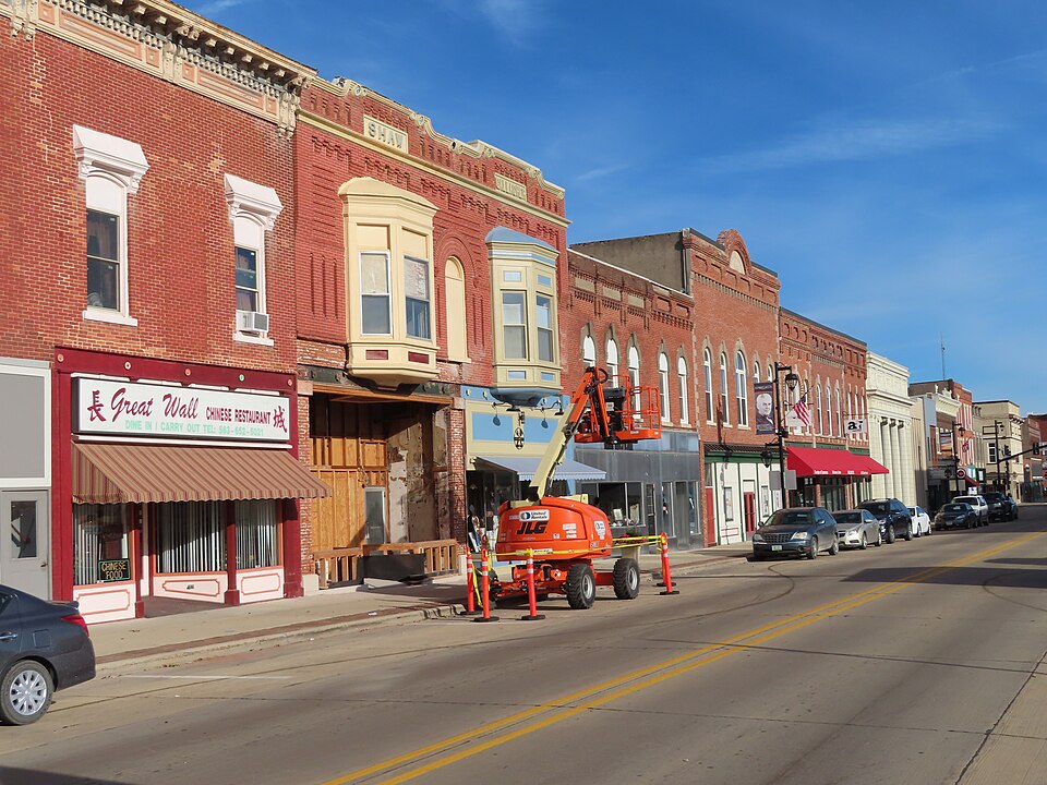
Listed on the National Register of Historic Places in 2022.
One of 77 National Register listings published here for Jackson County · listed in 2022 · category: District.
Sources: the National Register database, National Park Service
Regional context, not property-specific evidence. The federal wildfire occurrence database lists 11 fires within 5 miles of Maquoketa Commercial Historic District between 2009 and 2020, burning about 50 acres in total. None started naturally. None was recorded as arson. Distance is straight-line from the map coordinates, so a fire counted here may appear on a neighbouring settlement's page as well.
| Reported cause | Fires |
|---|---|
| Missing data/not specified/undetermined | 6 |
| Debris and open burning | 4 |
| Smoking | 1 |
The most recent of them, most recent first, with the day each was reported and the service that recorded it.
| Date | Cause | Size | Reported by | Name on the report |
|---|---|---|---|---|
| 27 July 2012 | Debris and open burning | 1.0 acres | Iowa Department of Natural Resources | not named |
| 5 June 2017 | Missing data/not specified/undetermined | 3.0 acres | Iowa Department of Natural Resources | not named |
| 19 May 2012 | Missing data/not specified/undetermined | under an acre | Iowa Department of Natural Resources | not named |
| 7 April 2017 | Missing data/not specified/undetermined | 1.0 acres | Iowa Department of Natural Resources | not named |
| 21 April 2020 | Smoking | under an acre | Iowa Department of Natural Resources | not named |
| 2 April 2011 | Missing data/not specified/undetermined | 15 acres | Iowa Department of Natural Resources | E SIDE OF RD, ACROSS FROM 15702 242ND AVE, MAQUOKE |
| 9 March 2017 | Debris and open burning | 2.0 acres | Iowa Department of Natural Resources | not named |
| 15 March 2009 | Missing data/not specified/undetermined | 1.0 acres | Iowa Department of Natural Resources | not named |
Regional context, not property-specific evidence. The federal mineral resources record lists 7 workings within 5 miles of Maquoketa Commercial Historic District: 4 past producers, 2 producers, 1 unknown. 2 still produce. What was taken out: Stone, Crushed/Broken, Sand and Gravel, Construction. Distance is straight-line from the map coordinates, so a quarry counted here may appear on a neighbouring settlement's page as well.
| Where | Site | Commodity | Status | Recorded |
|---|---|---|---|---|
| Rockdale Pit | Sand and Gravel, Construction | Past Producer | ||
| Frost Quarry | Stone, Crushed/Broken | Past Producer | ||
| Holtz Quarry | Stone, Crushed/Broken | Past Producer | ||
| Joinerville Quarry | Stone, Crushed/Broken | Producer | ||
| Maquoketa Quarry | Stone, Crushed/Broken | Producer | ||
| Unknown | Stone, Crushed/Broken | Unknown | ||
| Unknown | Stone, Crushed/Broken | Past Producer |
Regional context, not property-specific evidence. The National Weather Service names Maquoketa, the town this property stands in, in 76 storm reports between 1994 and 2025: 47 thunderstorm wind, 17 hail, 4 flood, 4 flash flood. The reports record 2 injuries. Each account below is quoted exactly as the forecast office filed it, from the NOAA Storm Events Database, and each date opens the federal record of that event.
| When | Event | Place named | Harm | What the report says |
|---|---|---|---|---|
| June 2010 | Tornado (EF1) | Maquoketa | 1 hurt, $250,000 | At approximately 740 pm June 5, an EF1 tornado moved across the northern edge of Maquoketa, IA. Wind speeds were estimated to be around 105 mph. Numerous trees were uprooted or snapped. Approximately 10 mobile homes and numerous vehicles were damaged by falling trees and tree limbs. A porch was torn from the front of a farm house and several outbuildings were damaged including an open-front garage that was completely destroyed. The sign at the elementary school school was destroyed and a rooftop air conditioner was moved, damaging the roof. |
| April 2007 | Thunderstorm Wind | Maquoketa | 1 hurt, $5,000 | A farm sustained damage to a machine shed and the residence as the storm moved through the area. Several tree limbs were blown down, one of which broke a bedroom window of the residence. The home owner was cut by the flying glass. Elsewhere in the vicinity, several tree limbs were downed and shingles were blown off some roofs. |
| September 2002 | Hail | Maquoketa | $20,000,000 | no account filed |
| July 2003 | Thunderstorm Wind | Maquoketa | $600,000 | Numerous trees down citywide |
| April 1995 | Thunderstorm Wind | Maquoketa | $100,000 | As the storm mentioned above tracked across the state, a dry slot moved out just ahead of it. Thunderstorms fired along and just ahead of the dry slot. The winds aloft were quite strong at the time as were the gradient winds. As a result, the thunderstorms became severe in terms of high winds. A downbust wind caused damage on a farmstead in Benton County for the first report of the morning. There was one sighting of a funnel cloud in Muscatine County. Several tractor-semitrailer trucks were overturned in Cedar County as the gusty winds blew them off the roads. One driver received minor injuries as he was pinned inside his truck west of Clarence. The storms and gusty winds continued to track northeast. A roof was removed off a business in Stanwood, impaling boards into the ground. Another roof was taken off by high winds at Mayville. There were several reports of barns being blown down by the wind gusts. Several trees were down, as were power lines as well throughout east-central Iowa. A significant amount of damage was reported in Maquoketa by high winds. There were reports of several buildings sustaining structural damage caused by the winds. The event was a short event as the storms tracked rapidly northeast into Illinois and Wisconsin. |
| June 2009 | Flash Flood | Maquoketa | $50,000 | Heavy rains resulted in flash flooding of many streets in Maquoketa, IA during the evening of June 19. |
| July 2007 | Flash Flood | Maquoketa | $25,000 | Three to six inches of rain fell in a short amount of time during the early morning hours of July 4th in Maquoketa, IA resulting in flash flooding. After receiving over 2 inches of rain in an hour, streets began to flood in Maquoketa around 1 AM. An additional 2 to 4 inches of rain had fallen by 3 AM. Flood waters 3 feet deep forced the closure of Highway 64 on the east side of town. The water was over the hoods of police squad cars. Several streets were flooded and or closed throughout the town including the intersections of South Fifth and Washington streets, Eddy and South Vermont streets, and 200th Avenue and Family Dollar parkway. A car was stalled in flood waters near the Eagle's Club. Prairie Creek overflowed its banks prompting the evacuation of campers in the Horseshoe Pond Park. A bridge was washed out at Lakehurst Dam near Maquoketa. A campground just south of Maquoketa also flooded rapidly forcing camping trailers to higher ground. In addition, the Maquoketa Caves State Park also had flooding, which damaged the lighting system in the park as well as washed debris into some caves prompting the closure of parts of the park for several days. Law enforcement, cooperative observers, and media sources also contributed to this report. |
| April 1995 | Thunderstorm Wind | Maquoketa | $25,000 | no account filed |
| August 2003 | Thunderstorm Wind | Maquoketa | $15,000 | Trees and Power lines down. |
| July 2003 | Hail | Maquoketa | $10,000 | no account filed |
| July 2003 | Hail | Maquoketa | $10,000 | no account filed |
| July 2003 | Hail | Maquoketa | $10,000 | no account filed |
| August 2006 | Thunderstorm Wind | Maquoketa | $8,000 | Co-operative observer reported 3 foot diameter trees down and two power poles snapped south of his farm. A considerable amount of corn was flattened with damage to some buildings. Time estimated based on radar. |
| August 2004 | Thunderstorm Wind | Maquoketa | $8,000 | Numerous streets closed due to downed trees and power lines. A 15 inch diameter tree down on a house.Only two severe reports were received in Jackson County. KDVN 88D reflectivity and velocity data suggests that damage may be more widespread across the southern part of the county during 1820-1930 CST (0020-0130 UTC). This would be consistent with the passage of the bookend vorticity as it moved across Jackson County. |
| July 2013 | Thunderstorm Wind | Maquoketa | $5,000 | Wind gusts estimated to be 75 mph blew down several large trees and a large billboard sign in Maquoketa, IA around 840 pm CDT July 22. Some trees fell onto power lines. This report was made on a media Facebook page. |
| July 2011 | Thunderstorm Wind | Maquoketa | $5,000 | Wind gusts estimated to be 60 mph blew down some branches in Maquoketa, IA around 630 am CDT July 11. Some streets were blocked by the branches. A power outage was also observed. |
| July 2006 | Thunderstorm Wind | Maquoketa | $5,000 | trees and power lines down |
| April 1994 | Thunderstorm Wind | Maquoketa | $5,000 | no account filed |
| July 1994 | Thunderstorm Wind | Maquoketa | $5,000 | no account filed |
| August 1994 | Hail | Maquoketa | $5,000 | no account filed |
| August 2004 | Thunderstorm Wind | Maquoketa | $3,000 | 8 inch diameter trees snapped off |
| August 2006 | Thunderstorm Wind | Maquoketa | $2,000 | A spotter reported a 7 inch diameter walnut limb down and a 9 inch diameter oak limb down. Heavy rain of 1.10 inches was also reported. |
| August 2006 | Thunderstorm Wind | Maquoketa | $2,000 | Co-operative observer reported 6 inch diameter limbs down with the power out along with 1.13 inches of rain. |
| May 2004 | Hail | Maquoketa | $2,000 | Reported by Co-op observer |
| July 2003 | Heavy Rain | Maquoketa | $2,000 | Occurred in 35 minutes with street flooding |
| August 2003 | Thunderstorm Wind | Maquoketa | $2,000 | Corn flattened with tree limbs down |
| August 2003 | Thunderstorm Wind | Maquoketa | $2,000 | Cherry & apple trees down |
| May 2004 | Hail | Maquoketa | $2,000 | no account filed |
| July 1995 | Thunderstorm Wind | Maquoketa | $2,000 | no account filed |
| May 1998 | Thunderstorm Wind | Maquoketa | $200 | no account filed |
| July 2025 | Thunderstorm Wind | Maquoketa | - | Broadcast Media reported several 4 to 6 inch tree limbs down in Maquoketa. Time of the event was estimated using radar. |
| July 2025 | Thunderstorm Wind | Maquoketa | - | Broadcast Media relayed a report of a large tree branch with down several smaller trees limbs down. The time of the event was estimated using radar. |
| July 2025 | Thunderstorm Wind | Maquoketa | - | A Mesonet site measured a thunderstorm wind gust of 50 knots. |
| May 2024 | Thunderstorm Wind | Maquoketa | - | Report of a tree uprooted. Time estimated from radar data. |
| May 2024 | Thunderstorm Wind | Maquoketa | - | Numerous large trees and branches down across town. A roof was blown off a building. |
| May 2024 | Thunderstorm Wind | Maquoketa | - | Large trees blown down, estimated 80 mph winds. |
| May 2024 | Thunderstorm Wind | Maquoketa | - | Maquoketa, Iowa Rwis station. |
| March 2023 | Hail | Maquoketa | - | A trained spotter reported dime to nickel sized hail. The time of event was estimated using radar. |
| June 2023 | Thunderstorm Wind | Maquoketa | - | Numerous branches blown down. |
| July 2023 | Thunderstorm Wind | Maquoketa | - | Tree limbs around three to four inches in diameter were downed in Maquoketa. |
| December 2021 | Thunderstorm Wind | Maquoketa | - | Iowa DOT automated observation. |
| December 2021 | Thunderstorm Wind | Maquoketa | - | Power poles were reported broken. |
| May 2020 | Tornado (EF0) | Maquoketa | - | Video passed along by emergency management confirms an EF-0 tornado, which caused some shingle damage at a few homes near Prairie Creek Golf Course, just south of Maquoketa, IA. The tornado path is around 1.5 miles long, and was on the ground for about 4 minutes. The maximum wind speed is estimated at 80 mph. |
| March 2019 | Flood | Maquoketa | - | Heavy rain and snow melt across the region caused the Maquoketa River at Maquoketa to rise above major flood stage of 28.5 feet on March 13th. The river fell back below major flood stage on the 16th. The river crested at 32.3 feet on the 15th. |
| October 2019 | Thunderstorm Wind | Maquoketa | - | Law enforcement reported a tree blown down onto power lines on the north side of Maquoketa, Iowa. |
| June 2019 | Thunderstorm Wind | Maquoketa | - | Numerous 2 to 4 inch diameter tree branches blown down. |
| June 2019 | Thunderstorm Wind | Maquoketa | - | Measured at the RWIS Iowa Department of Transportation. |
| September 2019 | Thunderstorm Wind | Maquoketa | - | A tree was blown down onto a power line. |
| August 2016 | Thunderstorm Wind | Maquoketa | - | A trained spotter reported an estimated wind gust around 60 MPH. |
| July 2016 | Thunderstorm Wind | Maquoketa | - | The emergency manager reported a couple of trees were uprooted in the town of Maquoketa. |
| November 2015 | Thunderstorm Wind | Maquoketa | - | The Jackson County Law Center reported a cattle shed was blown down on 300th avenue. |
| July 2014 | Flood | Maquoketa | - | Heavy rains across the Upper Midwest and eastern Iowa during the last 2 weeks of June caused the Maquoketa River at Maquoketa to rise above the major flood stage of 28.5 feet around 1245 AM on July 1 and fall below the major flood stage around 200 AM on July 2. The river crested at 30.6 feet from noon to 600 PM on July 1. |
| June 2014 | Thunderstorm Wind | Maquoketa | - | Measured 62 mph winds. |
| June 2014 | Thunderstorm Wind | Maquoketa | - | Measured 60 mph winds. |
| May 2013 | Thunderstorm Wind | Maquoketa | - | Multiple 1 foot diameter trees were snapped. |
| June 2010 | Thunderstorm Wind | Maquoketa | - | Wind gusts estimated to be 60 mph were observed in Maquoketa, IA at 722 pm CDT June 18. Newspapers later reported that numerous trees and branches were downed across town. |
| July 2006 | Heavy Rain | Maquoketa | - | from co-op observer; 3.01" inches of rain in 1 hour; most fell between 1200 to 1240 CST. |
| May 2004 | Hail | Maquoketa | - | North side of city |
| June 2002 | Flash Flood | Maquoketa | - | Water on south Main Street 2 to 3 feet deep. |
| July 2002 | Thunderstorm Wind | Maquoketa | - | A large tree limb was blown down, damaging the roof of a home on West Maple Street. Also, tree limbs knocked down several power lines resulting in scattered power outages. |
No historic map-sheet match is published for this property yet. That does not mean no map exists. This record needs a coordinate-quality review before it can be joined to a sheet boundary. Browse the county's mapped places while that work is pending.
Other National Register properties close enough to walk or drive between, ordered by distance from this one. Both positions come from the same geocoding pass that matched these properties to their map sheets.
| Photograph | Property | Distance | Listed |
|---|---|---|---|
 | Merrero Building | under 500 feet | 1991 |
 | IOOF Building | under 500 feet | 1991 |
 | New Era Building | under 500 feet | 1991 |
| D. H. Anderson Building | under 500 feet | 1986 | |
 | First National Bank | under 500 feet | 1991 |
 | Lyon Block | under 500 feet | 1991 |
| National Archives record | The nomination case file for reference 100007559 in Record Group 79. |
| Jackson County | All 77 listed properties in this county. |