 Block
From the record
One of 54 National Register listings published here for Henry County · listed in 2023 · category: District.
Sources: the National Register database, National Park Service
Listed on the National Register of Historic Places in 2023.
One of 54 National Register listings published here for Henry County · listed in 2023 · category: District.
Sources: the National Register database, National Park Service
Regional context, not property-specific evidence. The federal wildfire occurrence database lists 1 fire within 5 miles of West Main Street Residential Historic District in 2020, burning about 4 acres in total. None started naturally. None was recorded as arson. Distance is straight-line from the map coordinates, so a fire counted here may appear on a neighbouring settlement's page as well.
| Reported cause | Fires |
|---|---|
| Debris and open burning | 1 |
The most recent of them, most recent first, with the day each was reported and the service that recorded it.
| Date | Cause | Size | Reported by | Name on the report |
|---|---|---|---|---|
| 7 March 2020 | Debris and open burning | 4.0 acres | Iowa Department of Natural Resources | not named |
Regional context, not property-specific evidence. The federal mineral resources record lists 4 workings within 5 miles of West Main Street Residential Historic District: 3 past producers, 1 producer. 1 still produces. What was taken out: Stone, Crushed/Broken, Sand and Gravel, Construction. Distance is straight-line from the map coordinates, so a quarry counted here may appear on a neighbouring settlement's page as well.
| Where | Site | Commodity | Status | Recorded |
|---|---|---|---|---|
| Bain Pit | Sand and Gravel, Construction | Past Producer | ||
| Coppock Quarry | Stone, Crushed/Broken | Producer | ||
| Unknown | Sand and Gravel, Construction | Past Producer | ||
| Wayland Quarry | Stone, Crushed/Broken | Past Producer |
Regional context, not property-specific evidence. The National Weather Service names Wayland, the town this property stands in, in 20 storm reports between 1996 and 2026: 12 hail, 5 thunderstorm wind, 1 flash flood, 1 tornado. No death or injury is recorded in these reports. Each account below is quoted exactly as the forecast office filed it, from the NOAA Storm Events Database, and each date opens the federal record of that event.
| When | Event | Place named | Harm | What the report says |
|---|---|---|---|---|
| May 2012 | Tornado (EF2) | Wayland | $500,000 | The tornado began near 120th street near Wayland in Henry County and moved northeast to near Crawfordsville in Washington County. The tornado was on the ground for approximately 10 minutes in Henry County. Damage along the path of the tornado included: several farm outbuildings destroyed, roof damage to homes, trees snapped, and power poles damaged. The most severe damage occurred near and to the northeast of Noble (Washington County) where several turkey farms sustained extensive damage and two large wooden truss power poles were snapped off. Two homes between Noble and Crawfordsville had the roof removed as well as the exterior walls on the upper floor. One of the homes had a car lofted and tumbled across the yard. |
| April 2003 | Hail | Wayland | $100,000 | no account filed |
| September 2007 | Thunderstorm Wind | Wayland | $5,000 | Winds estimated to be 70 mph blew a portion of a roof of a mobile home off near Wayland, IA. Time estimated. |
| May 2005 | Thunderstorm Wind | Wayland | $5,000 | Downburst occurred over and immediately east of Wayland, Iowa. Several trees were downed including some that were 14 inches in diameter. One tree in town spared a direct hit on a house but took out the porch. |
| March 2026 | Hail | Wayland | - | A trained spotter estimated hail sizes o f a quarter to ping pong ball-sized hail. |
| March 2026 | Hail | Wayland | - | A member of the public reported golf ball sized hail via social media. |
| April 2026 | Thunderstorm Wind | Wayland | - | What was likely rear flank downdraft (RFD) winds and a strong dust whirl or gustnado on this wind surge based on three videos. The damage was a destroyed old grain bin and three outbuilding roofs, branches snapped, a tree downed, and to the press box at the soccer field at the high school. |
| July 2019 | Thunderstorm Wind | Wayland | - | The Wayland Fire Chief reports that numerous trees were down in town. A few structures had their roofs ripped off and a horse born was destroyed in the area. |
| June 2014 | Hail | Wayland | - | Law enforcement reported hail the size of quarters. |
| June 2014 | Hail | Wayland | - | A trained spotter reported dime to quarter size hail. |
| June 2014 | Hail | Wayland | - | A trained spotter reported dime to quarter size hail. |
| May 2014 | Funnel Cloud | Wayland | - | A funnel came down briefly and went back up into clouds near Wayland, IA around 238 pm CDT May 27. |
| April 2012 | Hail | Wayland | - | The public reported quarter size hail near Wayland. |
| August 2010 | Flash Flood | Wayland | - | Heavy rains resulted in the flash flooding of some streets in Coppock, IA during the late evening of August 13 and early morning of August 14. |
| August 2007 | Thunderstorm Wind | Wayland | - | Winds estimated to be 65 mph blew down a tree on Mill Street in Coppock, IA.| |
| March 2007 | Hail | Wayland | - | Trained spotter reported dime to penny size hail. |
| March 2026 | Hail | Wayland | - | no account filed |
| March 2026 | Hail | Wayland | - | no account filed |
| May 2023 | Hail | Wayland | - | no account filed |
| May 1996 | Hail | Wayland | - | no account filed |
No historic map-sheet match is published for this property yet. That does not mean no map exists. This record needs a coordinate-quality review before it can be joined to a sheet boundary. Browse the county's mapped places while that work is pending.
Other National Register properties close enough to walk or drive between, ordered by distance from this one. Both positions come from the same geocoding pass that matched these properties to their map sheets.
| Photograph | Property | Distance | Listed |
|---|---|---|---|
| Schantz, Christian K. and Margaret (Rich), House and Carpentry Shop | 0.2 miles | 2021 | |
| Samuel and Sarah Hulme House | 4.8 miles | 2019 | |
 | Swedish Evangelical Lutheran Church | 6.8 miles | 1999 |
 | Swedesburg Historic Commercial District | 6.9 miles | 1999 |
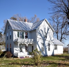 | Hult, Charles E., House, Summer Kitchen and Wood Shed | 6.9 miles | 1999 |
 | Red Ball Garage | 6.9 miles | 1999 |
| National Archives record | The nomination case file for reference 100009485 in Record Group 79. |
| Henry County | All 54 listed properties in this county. |