
BlockBefore
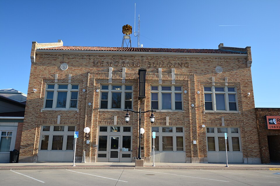
Photograph of Memorial Building
Photograph by Boscophotos, CC BY-SA 3.0. Via Wikimedia Commons.

Memorial Building

Listed on the National Register of Historic Places in 2013.

From the record

“Memorial Building, also known as Dyersville City Hall, is a historic building located in Dyersville, Iowa, United States. When this structure was completed in 1929 it housed the following functions: police department, fire department, municipal offices, post office, library, community hall, and gymnasium.”

Wikipedia article Memorial Building (Dyersville, Iowa), CC BY-SA 4.0.

One of 84 National Register listings published here for Dubuque County · listed in 2013 · category: Building.

Sources: the Wikipedia article · the National Register database, National Park Service · the Wikipedia article

The listing

  • What is counted as historic. The nomination lists 1 building as contributing to the listing.
  • Address. 340 1st Ave., E., Dyersville, 50703
  • When was it listed? April 2013
  • Category. building
  • Architectural style. Colonial Revival architecture
  • National Register reference number. 13000148 - assigned by the National Park Service when the property was listed.

Storms near this property

33 since 1995

Regional context, not property-specific evidence. The National Weather Service names Dyersville, the town this property stands in, in 33 storm reports between 1995 and 2024: 15 thunderstorm wind, 10 hail, 7 flash flood, 1 funnel cloud. No death or injury is recorded in these reports. Each account below is quoted exactly as the forecast office filed it, from the NOAA Storm Events Database, and each date opens the federal record of that event.

WhenEvent Place namedHarm What the report says
May 1999Flash FloodDyersville$5,000,000Flash flooding along the The North Fork of the Maquoketa River caused extensive damage in Dyersville. Numerous businesses across town sustained major damage. The costliest damage occurred at Scale Models, which sustained an estimated $150,000 in damage. Other businesses reported flooding to depths of 7 feet in their basements. About 100 people were evacuated from 60 homes. State officials set the preliminary damage estimates from Dyersville at $3 to $5 million.
June 2009Thunderstorm WindDyersville$25,000Wind gusts estimated to be 70 to 80 mph damaged numerous outbuildings south of Dyersville, IA around 830 am June 19.
June 2008Flash FloodDyersville$25,000Heavy rains caused rapid rises in river levels along the North Fork Maquoketa River resulting in some flash flooding in Dyersville, IA around 2:00 pm June 8. Some Dyersville residences along the river were evacuated.
July 2008Thunderstorm WindDyersville$5,000Wind gusts estimated to be 65 mph uprooted a tree and blew down power lines just east of Dyersville, IA at 435 pm July 2.
May 2004Thunderstorm WindDyersville$5,000Trees and power lines down with rural structural damage.
July 1995Thunderstorm WindDyersville$5,000no account filed
September 2016Flash FloodDyersville$2,000The county emergency manager reported flash flooding was flowing into some homes basements. The fire department is responding to the incident.
July 2011Thunderstorm WindDyersville$1,000Wind gusts estimated to be 70 mph caused some tree damage in Dyersville, IA around 540 am CDT July 11. A fishing boat and fence were also damaged and utility lines were downed.
June 2024Thunderstorm WindDyersville-Power pole leaning due to thunderstorm winds.
June 2023Thunderstorm WindDyersville-A large tree limb was blown down.
August 2021Thunderstorm WindDyersville-Very strong winds reported.
August 2021Thunderstorm WindDyersville-Measured at the fire station.
May 2017Thunderstorm WindDyersville-The county emergency manager reported a measured wind gust of 63 knots.
July 2012Thunderstorm WindDyersville-A trained spotter reported tree limbs down near Dyersville.
April 2011HailDyersville-Quarter sized hail fell 1 mile southeast of Dyersville, IA at 728 pm CDT April 3.
August 2009Thunderstorm WindDyersville-Wind gusts estimated to be 65 mph were observed in Dyersville, IA around 1250 pm August 9.
April 2008Flash FloodDyersville-Law enforcement reported that some roads were closed due to high water in Dyersville.
May 2008Flash FloodDyersville-Heavy rains of 3 to 8 inches caused flash flooding of western parts of Dyersville, IA during the late evening of May 25th and early morning of May 26th. The North Fork Maquoketa River and Bear Creek were particularly affected with flooding. Some streets in town had to be closed due to the flood waters as well as Floyd Road and 180th Street in rural areas.
May 2008HailDyersville-Quarter-sized hail fell in Dyersville, IA shortly after 10:01 pm on May 25th according to the Dyersville emergency management director.
May 2008HailDyersville-Quarter-sized hail fell just north of Dyersville, IA around 7:48 pm.
April 2007HailDyersville-Time estimated.
August 2004Funnel CloudDyersville-Location is actually in Eastern Delaware County 4.2 miles northwest of Worthington. Spotters from the Dyersville Fire Department and in Worthington briefly glimpsed the Hopkinton Tornado as it roped out and dissipated on the horizon.
June 2002Flash FloodDyersville-Parts of the city evacuated due to high water. Trained spotter measured 5 inches of rain in 12 hours.
June 2002Thunderstorm WindDyersville-Several large trees and numerous branches knocked down.
August 2002Flash FloodDyersville-Significant street flooding.
June 2001HailDyersville-Quarter sized hail reported by law enforcement.
August 2021HailDyersville-no account filed
May 2017HailDyersville-no account filed
June 2015Thunderstorm WindDyersville-no account filed
August 2009HailDyersville-no account filed
April 2007HailDyersville-no account filed
May 1998Thunderstorm WindDyersville-no account filed
May 1997HailDyersville-no account filed

Every storm recorded in Dubuque County

Map coverage status

No historic map-sheet match is published for this property yet. That does not mean no map exists. This record needs a coordinate-quality review before it can be joined to a sheet boundary. Browse the county's mapped places while that work is pending.

Sources for this property

National Archives recordThe nomination case file for reference 13000148 in Record Group 79.
Wikipedia articleCommunity-written account of this property, licensed CC BY-SA.
Dubuque CountyAll 84 listed properties in this county.

Provenance

  • Listing record. National Park Service National Register of Historic Places, listed-properties dataset, current to 2026-05-22.
  • Map join. Address geocoded through the United States Census geocoder, then tested against the published boundary of every sheet in the USGS Historical Topographic Map Collection.
  • How this page is made. Listing fields come from federal records; map-sheet coverage is a labelled coordinate-to-boundary calculation, not a source-field claim.
  • Storms. NOAA National Centers for Environmental Information, Storm Events Database https://www.ncei.noaa.gov/stormevents/ A work of the United States government, no copyright under 17 U.S.C. 105. Narratives are quoted verbatim from the National Weather Service report and are not edited or summarised.