
BlockBefore
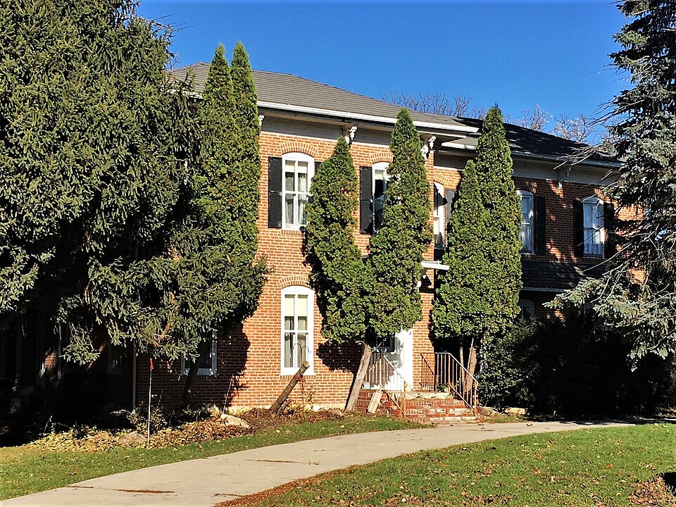
Photograph of James C. Fellows House
Photograph by Jon Roanhaus, CC BY-SA 4.0. Via Wikimedia Commons.

James C. Fellows House

Listed on the National Register of Historic Places in 1982.

From the record

“Fellows House is a historic building located in Riceville, Iowa, United States. Fellows was a brick mason who settled in Riceville in 1856 with his brother Harris, who was a physician.”

Wikipedia article James C. Fellows House, CC BY-SA 4.0.

One of 8 National Register listings published here for Howard County · listed in 1982 · category: Building.

Sources: the Wikipedia article · the case file at the National Archives · the National Register database, National Park Service

The listing

  • Listed as. Fellows, James C., House - the National Register files a house under its owner's surname.
  • Address. Main St., Riceville, 50466
  • When was it listed? June 1982
  • Category. building
  • Township. Jamestown township
  • National Register reference number. 82002621 - the number the National Park Service assigned this property when it was listed, and the key its nomination file is catalogued under at the National Archives.

Fires near this property

4 since 2008

Regional context, not property-specific evidence. The federal wildfire occurrence database lists 4 fires within 5 miles of James C. Fellows House between 2008 and 2011, burning about 33 acres in total. None started naturally. None was recorded as arson. Distance is straight-line from the map coordinates, so a fire counted here may appear on a neighbouring settlement's page as well.

Reported cause Fires
Missing data/not specified/undetermined4

The most recent of them, most recent first, with the day each was reported and the service that recorded it.

DateCause SizeReported by Name on the report
23 May 2008Missing data/not specified/undetermined1.0 acresIowa Department of Natural Resourcesnot named
19 May 2009Missing data/not specified/undetermined15 acresIowa Department of Natural Resourcesnot named
6 April 2011Missing data/not specified/undetermined15 acresIowa Department of Natural Resources1975 ADDISON AVE, IA
14 April 2009Missing data/not specified/undetermined2.0 acresIowa Department of Natural Resourcesnot named

Every fire recorded in Howard County

Mines and quarries near this property

5 within 5 miles

Regional context, not property-specific evidence. The federal mineral resources record lists 5 workings within 5 miles of James C. Fellows House: 3 unknowns, 1 past producer, 1 producer. 1 still produces. What was taken out: Sand and Gravel, Construction, Stone, Crushed/Broken. Distance is straight-line from the map coordinates, so a quarry counted here may appear on a neighbouring settlement's page as well.

Where SiteCommodity StatusRecorded
Aspel QuarryStone, Crushed/BrokenProducer
UnknownSand and Gravel, ConstructionUnknown
UnknownSand and Gravel, ConstructionPast Producer
UnknownSand and Gravel, ConstructionUnknown

Every working recorded in Howard County

Storms near this property

31 since 1996

Regional context, not property-specific evidence. The National Weather Service names Riceville, the town this property stands in, in 31 storm reports between 1996 and 2025: 9 thunderstorm wind, 7 hail, 5 tornado, 4 heavy rain. The reports record 5 injuries. Each account below is quoted exactly as the forecast office filed it, from the NOAA Storm Events Database, and each date opens the federal record of that event.

WhenEvent Place namedHarm What the report says
May 2011Tornado (EF2)Riceville3 hurt, $525,000This tornado first caused some damage about 3 miles north of State Highway 9 north of Riceville. The tornado almost immediately strengthen to EF1 as it moved northeast. Several farms had outbuildings destroyed, widespread tree damage occurred and several homes had partial or complete roof damage. As the tornado passed south of Chester, it increased to its maximum width and strength. The tornado remained at EF2 strength as it crossed the state line into Fillmore County Minnesota. The tornado passed through rural portions of the county affecting around a dozen farms with only three minor injuries occurring. Around 850 customers were loss power as a result of the storms. Damages were estimated to be around $500 thousand.
August 2012LightningRiceville2 hurtTwo young boys were injured when lightning struck a tree they were taking shelter under while fishing at the Lake Hendricks park and campground near Riceville. One boy was listed in critical condition after being transferred to St. Marys hospital in Rochester, Minnesota. The second boy only received minor injuries and was treated and released from a local hospital.
August 2016FloodRiceville$470,000State Highway 9 was closed west of Cresco due to flood waters from the North Branch of the Turkey River. The flood waters from the North Branch of the Turkey River also washed out Robin Avenue. Lidtke County Park just north of Lime Springs was flooded by the Upper Iowa River. A small mudslide occurred along Watsons Creek in Lake Hendricks Park in Riceville. The county engineer estimated there were over 450 locations where water was over roads with only minor damage reported. In Cresco, several houses had water in the basements. School was canceled in the Howard-Winneshiek and Riceville school districts.
June 2004Tornado (F3)Riceville$190,000no account filed
June 2004Tornado (F0)Riceville$100,000no account filed
April 2022Tornado (EF1)Riceville$25,000This EF1 tornado moved into Howard County south of Riceville and moved to the northeast before dissipating southeast of Riceville. Damage was mainly limited to trees.
September 2011Thunderstorm WindRiceville$12,000Widespread tree damage and power outages occurred in Riceville. Also, two light poles were blown down at the Rasmussen High School football field. One of the poles fell on a set of portable bleachers.
March 2025Thunderstorm WindRiceville$5,000Local media reported several instances of wind damage around Riceville High School.
May 2022Thunderstorm WindRiceville$5,000Power lines were blown down between Riceville and Elma.
June 2014LightningRiceville$5,000A lightning strike started a fire in Riceville.
August 1996Thunderstorm WindRiceville$2,000no account filed
June 2014Thunderstorm WindRiceville$1,500At least three trees were blown down on the southeast side of Riceville.
September 2024HailRiceville-Local businesses south of Riceville reported penny to nickel sized hail.
September 2024HailRiceville-The public reported quarter sized hail 4 miles southeast of Riceville. Damage to was also noted to the crops from the hail.
March 2017HailRiceville-Quarter sized hail fell in Riceville.
June 2016Flash FloodRiceville-Heavy rain caused Cranes Creek to go out of its banks in several locations across western Howard County.
June 2016Heavy RainRiceville-In Riceville, 5.54 inches of rain was reported.
June 2016Heavy RainRiceville-The mesonet reporting station near Riceville measured 3.79 inches of rain.
September 2016Heavy RainRiceville-Near Riceville, 4.54 inches of rain fell.
August 2016Heavy RainRiceville-A mesonet reporting station northeast of Riceville measured 4.26 inches of rain.
June 2014Thunderstorm WindRiceville-The mesonet weather observing equipment east of Riceville measured a wind gust of 71 mph.
June 2013Flash FloodRiceville-Heavy rain pushed the Upper Iowa River and numerous smaller streams that drain into the Upper Iowa River out of their banks. The water covered several roads across the northern portion of Howard County.
September 2011Thunderstorm WindRiceville-Numerous corn fields were flattened across Howard County. The USDA estimated that almost 3200 acres of corn were destroyed while 16,000 acres suffered a 25 bushel per acre yield loss. Total crop losses were estimated to be around $7.5 million. The U.S. Department of Agriculture issued a natural disaster designation for this damage.
May 2008Funnel CloudRiceville-A trained spotter reported a funnel cloud southeast of Riceville.
March 2017HailRiceville-no account filed
May 2012HailRiceville-no account filed
June 2008HailRiceville-no account filed
June 2007HailRiceville-no account filed
July 2006Thunderstorm WindRiceville-no account filed
June 2004Tornado (F0)Riceville-no account filed
June 1998Thunderstorm WindRiceville-no account filed

Every storm recorded in Howard County

Map coverage status

No historic map-sheet match is published for this property yet. That does not mean no map exists. This record needs a coordinate-quality review before it can be joined to a sheet boundary. Browse the county's mapped places while that work is pending.

Sources for this property

National Archives recordThe nomination case file for reference 82002621 in Record Group 79.
Wikipedia articleCommunity-written account of this property, licensed CC BY-SA.
Howard CountyAll 8 listed properties in this county.

Provenance

  • Listing record. National Park Service National Register of Historic Places, listed-properties dataset, current to 2026-05-22.
  • Map join. Address geocoded through the United States Census geocoder, then tested against the published boundary of every sheet in the USGS Historical Topographic Map Collection.
  • How this page is made. Listing fields come from federal records; map-sheet coverage is a labelled coordinate-to-boundary calculation, not a source-field claim.
  • Wildfire. Short, Karen C. 2022. Spatial wildfire occurrence data for the United States, 1992-2020 [FPA_FOD_20221014]. 6th Edition. Fort Collins, CO: Forest Service Research Data Archive. https://doi.org/10.2737/RDS-2013-0009.6 Collected with United States Government funding and usable without additional permissions or fees.
  • Mines and quarries. USGS Mineral Resources Data System (MRDS) https://mrdata.usgs.gov/mrds/ A work of the United States government, no copyright under 17 U.S.C. 105.
  • Storms. NOAA National Centers for Environmental Information, Storm Events Database https://www.ncei.noaa.gov/stormevents/ A work of the United States government, no copyright under 17 U.S.C. 105. Narratives are quoted verbatim from the National Weather Service report and are not edited or summarised.