
BlockBefore
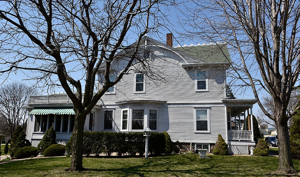
Photograph of Sauser-Lane House
Photograph by Boscophotos, CC BY-SA 3.0. Via Wikimedia Commons.

Sauser-Lane House

Listed on the National Register of Historic Places in 1983.

From the record

“The Sauser-Lane House is a historic building located in Cascade, Iowa, United States. Sauser had been an area farmer and owned a Cascade lumber business when he built this house in 1908.”

Wikipedia article Sauser-Lane House, CC BY-SA 4.0.

One of 84 National Register listings published here for Dubuque County · listed in 1983 · category: Building.

Sources: the Wikipedia article · the case file at the National Archives · the National Register database, National Park Service

The listing

  • What is counted as historic. The nomination lists 1 building as contributing to the listing.
  • Address. 101 2nd Ave., SW, Cascade, 52033
  • When was it listed? July 1983
  • Category. building
  • Township. Whitewater township
  • Architectural style. Neoclassical architecture
  • National Register reference number. 83000354 - the number the National Park Service assigned this property when it was listed, and the key its nomination file is catalogued under at the National Archives.

Mines and quarries near this property

7 within 5 miles

Regional context, not property-specific evidence. The federal mineral resources record lists 7 workings within 5 miles of Sauser-Lane House: 5 past producers, 2 producers. 2 still produce. What was taken out: Stone, Crushed/Broken, Sand and Gravel, Construction. Distance is straight-line from the map coordinates, so a quarry counted here may appear on a neighbouring settlement's page as well.

Where SiteCommodity StatusRecorded
Sauser Sand PitSand and Gravel, ConstructionProducer
UnknownSand and Gravel, ConstructionPast Producer
Kurt QuarryStone, Crushed/BrokenPast Producer
Reiter QuarryStone, Crushed/BrokenProducer
UnknownStone, Crushed/BrokenPast Producer

Every working recorded in Dubuque County

Storms near this property

36 since 1995

Regional context, not property-specific evidence. The National Weather Service names Cascade, the town this property stands in, in 36 storm reports between 1995 and 2026: 18 hail, 11 thunderstorm wind, 3 funnel cloud, 2 flash flood. No death or injury is recorded in these reports. Each account below is quoted exactly as the forecast office filed it, from the NOAA Storm Events Database, and each date opens the federal record of that event.

WhenEvent Place namedHarm What the report says
July 1995HailCascade$10,000no account filed
July 2006Thunderstorm WindCascade$1,000very large tree down
April 2026HailCascade-Report received from Mping.
April 2026Thunderstorm WindCascade-The time was estimated using radar data.
July 2025Tornado (EF0)Cascade-An EF-1 tornado with a maximum estimated wind speed of 95 MPH identified by satellite data and confirmed by aerial survey. This tornado damaged mainly crops along its 3.4 mile long path. Towards the end of its path it destroyed a hoop building, removed a roof of a farm outbuilding and destroyed a garage at a residence. A woman was trapped in the garage as it collapsed around her.
August 2023Funnel CloudCascade-A trained spotter observed a funnel cloud extending halfway down from the cloud base.
August 2023Funnel CloudCascade-Emergency Manager reported a funnel cloud near Cascade.
August 2023Tornado (EFU)Cascade-Video and photo evidence indicated a brief tornado in open farm ground. The tornado was rated EF-U as there was no observable damage other than a convergent path in the corn. The tornado was the on ground for a little over a mile.
August 2020HailCascade-This fell from storms just north of the track of the derecho path.
March 2017Thunderstorm WindCascade-A measured wind gust of 56 kts was received from the local emergency manager.
May 2016Thunderstorm WindCascade-The fire department reported an estimated wind gust of 60 MPH and was relayed by the Dubuque County EOC.
July 2016Thunderstorm WindCascade-A trained spotter reported multiple trees and power lines were down within town. The time was estimated based upon radar.
July 2016Thunderstorm WindCascade-A trained spotter reported wind gusts up to 70 MPH in Cascade.
May 2014HailCascade-Golf ball sized hail fell in Cascade, IA at 544 pm CDT May 20.
May 2014HailCascade-Ping pong ball sized hail fell about 1 mile north of Cascade, IA near Macomber Road at 528 pm CDT May 20.
April 2010Thunderstorm WindCascade-A 58 mph wind gust was measured at the Cascade, IA Fire Department at 1040 pm April 5.
June 2010Thunderstorm WindCascade-A large tree in Calvary Cemetery was blown down.
July 2009HailCascade-Pea to quarter-sized hail covered the ground in Cascade, IA around 315 pm July 24.
January 2008HailCascade-Law enforcement reported penny size hail covering the ground in Cascade.
August 2008HailCascade-Nickel-sized hail fell in Cascade, IA at 648 am August 3.
August 2008HailCascade-Nickel-sized hail fell in Cascade, IA around 550 pm August 4.
April 2007HailCascade-Time estimated.
June 2002Flash FloodCascade-Highway 151 closed between Cascade and Monticello. Water reported to be up to the fuel tanks on semi trucks.
August 2002Flash FloodCascade-Numerous streets inundated with high water and debris.
March 2026HailCascade-no account filed
April 2026Thunderstorm WindCascade-no account filed
June 2010HailCascade-no account filed
July 2009HailCascade-no account filed
April 2007HailCascade-no account filed
May 2004Funnel CloudCascade-no account filed
May 1998HailCascade-no account filed
August 1998Thunderstorm WindCascade-no account filed
August 1996Thunderstorm WindCascade-no account filed

Every storm recorded in Dubuque County

Map coverage status

No historic map-sheet match is published for this property yet. That does not mean no map exists. This record needs a coordinate-quality review before it can be joined to a sheet boundary. Browse the county's mapped places while that work is pending.

Sources for this property

National Archives recordThe nomination case file for reference 83000354 in Record Group 79.
Wikipedia articleCommunity-written account of this property, licensed CC BY-SA.
Dubuque CountyAll 84 listed properties in this county.

Provenance

  • Listing record. National Park Service National Register of Historic Places, listed-properties dataset, current to 2026-05-22.
  • Map join. Address geocoded through the United States Census geocoder, then tested against the published boundary of every sheet in the USGS Historical Topographic Map Collection.
  • How this page is made. Listing fields come from federal records; map-sheet coverage is a labelled coordinate-to-boundary calculation, not a source-field claim.
  • Mines and quarries. USGS Mineral Resources Data System (MRDS) https://mrdata.usgs.gov/mrds/ A work of the United States government, no copyright under 17 U.S.C. 105.
  • Storms. NOAA National Centers for Environmental Information, Storm Events Database https://www.ncei.noaa.gov/stormevents/ A work of the United States government, no copyright under 17 U.S.C. 105. Narratives are quoted verbatim from the National Weather Service report and are not edited or summarised.