BlockBefore
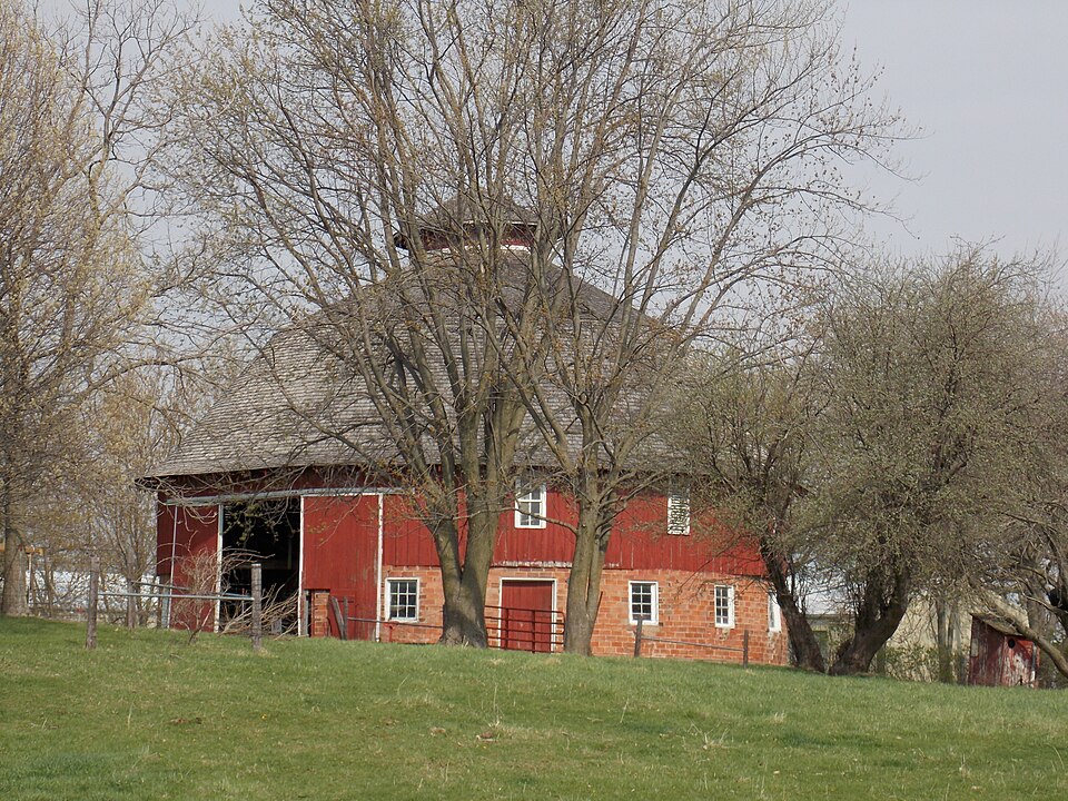
Photograph of Nebergall "Knoll Crest" Round Barn
Photograph by Farragutful, CC BY-SA 3.0. Via Wikimedia Commons.

Nebergall "Knoll Crest" Round Barn

Listed on the National Register of Historic Places in 1986.

From the record

“The Nebergall "Knoll Crest" Round Barn is located between Davenport and Blue Grass in rural Scott County, Iowa, United States. It was built in 1914, and has been listed on the National Register of Historic Places since 1986.”

Wikipedia article Nebergall "Knoll Crest" Round Barn, CC BY-SA 4.0.

One of 296 National Register listings published here for Scott County · listed in 1986 · category: Building.

Sources: the Wikipedia article · the case file at the National Archives · the National Register database, National Park Service

The listing

  • What is counted as historic. The nomination lists 1 building as contributing to the listing.
  • Address. Telegraph Rd., Blue Grass, 52804
  • When was it listed? June 1986
  • Category. building
  • Also known as. Iowa Round Barns: The Sixty Year Experiment TR
  • Township. Blue Grass township
  • National Register reference number. 86001473 - the number the National Park Service assigned this property when it was listed, and the key its nomination file is catalogued under at the National Archives.

Mines and quarries near this property

5 within 5 miles

Regional context, not property-specific evidence. The federal mineral resources record lists 5 workings within 5 miles of Nebergall "Knoll Crest" Round Barn: 5 producers. All of them still produce. What was taken out: Stone, Crushed/Broken, Salt, Calcium. Distance is straight-line from the map coordinates, so a quarry counted here may appear on a neighbouring settlement's page as well.

Where SiteCommodity StatusRecorded
Cargill Salt Terminal SaSaltProducer
Linwood Lime PlantCalciumProducer
Davenport QuarryStone, Crushed/BrokenProducer
Linwood Stone Products Mine & MillStone, Crushed/BrokenProducer
Martin Marietta-Buffalo Cement PlntStone, Crushed/BrokenProducer

Every working recorded in Scott County

Storms near this property

29 since 1996

Regional context, not property-specific evidence. The National Weather Service names Blue Grass, the town this property stands in, in 29 storm reports between 1996 and 2025: 12 hail, 10 thunderstorm wind, 4 tornado, 2 funnel cloud. The reports record 3 injuries. Each account below is quoted exactly as the forecast office filed it, from the NOAA Storm Events Database, and each date opens the federal record of that event.

WhenEvent Place namedHarm What the report says
June 2001Tornado (F2)Blue Grass3 hurtno account filed
March 2017Tornado (EF2)Blue Grass$50,000This is a continuation of the Tornado that started in Muscatine County. Power poles were snapped, a house was un-roofed, and numerous farm outbuildings and trees were damaged.
June 1997Thunderstorm WindBlue Grass$40,000Winds destroyed a two story building at a local race track. This building housed the announcer's booth, concession stand, and track offices.
July 2003HailBlue Grass$30,000no account filed
August 2003HailBlue Grass$10,000no account filed
June 2010Thunderstorm WindBlue Grass$200Wind gusts estimated to be 60 mph caused some tree and property damage about 1 mile south of Blue Grass, IA around 425 pm June 23. A flag pole was bent. A gazebo was blown over. Several tree limbs were blown down. Pea-sized hail and a power outage was also observed.
July 2025Thunderstorm WindBlue Grass-A public report of a downed wooden light pole onto a baseball field. The time of the event was estimated using radar.
February 2024HailBlue Grass-Report relayed by media.
March 2022Tornado (EF0)Blue Grass-A NWS Storm Survey found that a brief weak tornado damaged a shed and some trees. The peak estimated wind speed is 65 MPH.
November 2022Thunderstorm WindBlue Grass-An NWS Employee reported a tree down near their residence. The time of the event was estimated using radar.
June 2020HailBlue Grass-A trained spotter driving through Blue Grass reported hail that was three quarters of an inch or larger with wind gusts around 55 MPH.
June 2020HailBlue Grass-An off duty firefighter reported quarter to golf ball size hail.
July 2013FloodBlue Grass-The Mississippi River at Rock Island rose to its major flood stage level at 1 am CDT July 1, remaining at that level until 1 am CDT July 2. ||The Mississippi River at Muscatine rose to its major flood stage level at 1 pm CDT July 1, remaining at that level until 7 pm CDT July 1.
June 2009Thunderstorm WindBlue Grass-Wind gusts were estimated to be 70 mph in Blue Grass, IA around 533 pm June 19.
June 2008HailBlue Grass-Penny-sized hail fell in Blue Grass, IA at 7:25 pm June 12.
June 2007Thunderstorm WindBlue Grass-Tree limbs were blown down in Blue Grass.
August 2002Tornado (F0)Blue Grass-An F0 tornado touched down briefly north of Blue Grass tearing down a large tree limb. Otherwise, no injuries or damage was reported.
May 2001Funnel CloudBlue Grass-Two funnel clouds reported by trained storm spotter.
July 2001Thunderstorm WindBlue Grass-Several 6 inch limbs downed. Reported by off duty NWS employee.
June 1999Thunderstorm WindBlue Grass-Several tree limbs and power poles downed.
June 1999Thunderstorm WindBlue Grass-Power lines downed.
September 2017HailBlue Grass-no account filed
November 2013HailBlue Grass-no account filed
May 2011HailBlue Grass-no account filed
May 2004HailBlue Grass-no account filed
August 2002Funnel CloudBlue Grass-no account filed
May 2000HailBlue Grass-no account filed
June 1999HailBlue Grass-no account filed
October 1996Thunderstorm WindBlue Grass-no account filed

Every storm recorded in Scott County

Map coverage status

No historic map-sheet match is published for this property yet. That does not mean no map exists. This record needs a coordinate-quality review before it can be joined to a sheet boundary. Browse the county's mapped places while that work is pending.

Listed places nearby

6 within 8 miles

Other National Register properties close enough to walk or drive between, ordered by distance from this one. Both positions come from the same geocoding pass that matched these properties to their map sheets.

Photograph PropertyDistance Listed
Westphal-Schmidt House0.3 miles1984
Royal Neighbors of America National Home Historic District3.6 miles2015
John Schricker House3.8 miles1985
Joseph S. McHarg House3.8 miles1985
Buffalo High School3.9 miles2005
Davenport Crematorium4.3 miles1983

Sources for this property

National Archives recordThe nomination case file for reference 86001473 in Record Group 79.
Wikipedia articleCommunity-written account of this property, licensed CC BY-SA.
Scott CountyAll 296 listed properties in this county.

Provenance

  • Listing record. National Park Service National Register of Historic Places, listed-properties dataset, current to 2026-05-22.
  • Map join. Address geocoded through the United States Census geocoder, then tested against the published boundary of every sheet in the USGS Historical Topographic Map Collection.
  • How this page is made. Listing fields come from federal records; map-sheet coverage is a labelled coordinate-to-boundary calculation, not a source-field claim.
  • Mines and quarries. USGS Mineral Resources Data System (MRDS) https://mrdata.usgs.gov/mrds/ A work of the United States government, no copyright under 17 U.S.C. 105.
  • Storms. NOAA National Centers for Environmental Information, Storm Events Database https://www.ncei.noaa.gov/stormevents/ A work of the United States government, no copyright under 17 U.S.C. 105. Narratives are quoted verbatim from the National Weather Service report and are not edited or summarised.