
BlockBefore
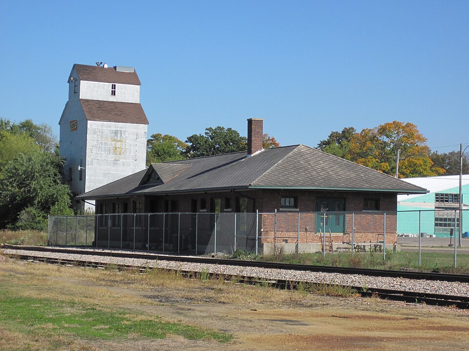
Photograph of Illinois Central Combination Depot-Ackley
Photograph by Billwhittaker at English Wikipedia, CC BY-SA 3.0. Via Wikimedia Commons.

Illinois Central Combination Depot-Ackley

Listed on the National Register of Historic Places in 1990.

From the record

“Ackley station is a former railroad station located in Ackley, Iowa, United States. The Dubuque & Sioux City Railroad, an affiliate of the Illinois Central Railroad, laid the first rail track to Iowa Falls in 1865.”

Wikipedia article Ackley station, CC BY-SA 4.0.

One of 34 National Register listings published here for Hardin County · listed in 1990 · category: Building.

Sources: the Wikipedia article · the case file at the National Archives · the National Register database, National Park Service

The listing

  • What is counted as historic. The nomination lists 1 building as contributing to the listing.
  • Listed as. Illinois Central Combination Depot--Ackley - the National Register files a house under its owner's surname.
  • Address. N. of Railroad St., between State and Mitchell Sts., Ackley, 50601
  • When was it listed? September 1990
  • Category. building
  • Also known as. Advent & Development of Railroads in Iowa MPS
  • Township. Etna township
  • Architectural style. Tudor Revival architecture
  • National Register reference number. 90001303 - the number the National Park Service assigned this property when it was listed, and the key its nomination file is catalogued under at the National Archives.

Mines and quarries near this property

4 within 5 miles

Regional context, not property-specific evidence. The federal mineral resources record lists 4 workings within 5 miles of Illinois Central Combination Depot-Ackley: 2 past producers, 1 unknown, 1 producer. 1 still produces. What was taken out: Sand and Gravel, Construction, Stone, Crushed/Broken. Distance is straight-line from the map coordinates, so a quarry counted here may appear on a neighbouring settlement's page as well.

Where SiteCommodity StatusRecorded
Brandt PitSand and Gravel, ConstructionProducer
Humke QuarryStone, Crushed/BrokenUnknown
Park QuarryStone, Crushed/BrokenPast Producer
UnknownSand and Gravel, ConstructionPast Producer

Every working recorded in Hardin County

Storms near this property

26 since 1995

Regional context, not property-specific evidence. The National Weather Service names Ackley, the town this property stands in, in 26 storm reports between 1995 and 2025: 11 hail, 8 thunderstorm wind, 2 tornado, 2 flash flood. No death or injury is recorded in these reports. Each account below is quoted exactly as the forecast office filed it, from the NOAA Storm Events Database, and each date opens the federal record of that event.

WhenEvent Place namedHarm What the report says
June 2013Flash FloodAckley$250,000Parts of S56 is flooded. Several roads near Ackley were flooded.
August 1995Thunderstorm WindAckley$30,000A very warm and unstable air mass was over Iowa as a stationarrowy front extended from central Nebraska into southern Wisconsin. CAPE values were between 3000 and 4000 J-kg-1 over the state. Thunderstorms erupted over northwest Iowa and spread into the north central and eventually the northeast counties. For the most part the storms just produced heavy rainfall and gusty winds. During the early stages of the systems development there was some severe weather. High winds were reported in Worth County. Seventy mile an hour winds blew through areas south of Mason City in Cerro Gordo County southeast to the Rockwell area a small bow echo traversed the area. Other high winds occurred in the Estherville area of Emmet County with numerous trees down and also at Marquette in Clayton County. One of the storms produced a brief spin up tornado, or gustnado, northwest of Garner. An observer reported the brief touchdown in his front yard. Damage was very minor however. The storms produced copious amounts of rain. Parts of Cerro Gordo County, south of Mason City, received between five and six inches of rain in under three hours. Two and one half inches fell in an hours time. Widespread street flooding was reported with most streets under at least six inches of water. Parts of the city reported water knee deep. The water receded fairly quickly as antecedent conditions were very dry. The storms the dumped the heavy rainfall were the result of back development from the storms that moved through earlier in the evening. One of the storms did become severe and caused damage to several cabins northeast of Clarion. High winds downed several trees in the area as well. Farther to the east and south, a thunderstorm downed trees in the Ackley area. Winds of at least 70 MPH in what appeared to be a downburst completely flattened 32 acres of a corn field northeast of town.
March 2006Thunderstorm WindAckley$25,000no account filed
July 2016Thunderstorm WindAckley$20,000Law Enforcement reported several power lines and large trees down throughout the town of Ackley, as well as other portions of Hardin County.
June 2009Thunderstorm WindAckley$15,000Large trees were down throughout town making streets impassible. Some trees were on houses.
June 2014Flash FloodAckley$5,000Water was running over the road. County closed the road.
June 2005Thunderstorm WindAckley$5,000no account filed
August 2004HailAckley$5,000no account filed
June 2001HailAckley$5,000no account filed
August 2004Thunderstorm WindAckley$3,000no account filed
August 2004Tornado (F1)Ackley$2,000Tornado touched down in farm fields and remained in open country. It caused little damage.
June 2005HailAckley$2,000no account filed
June 2005Thunderstorm WindAckley$1,000no account filed
June 2005HailAckley$1,000no account filed
May 2024HailAckley-Submitted picture of penny sized hail in Ackley. Time estimated by radar.
July 2018Funnel CloudAckley-Hardin County Sheriff relayed public reports of a funnel cloud near Ackley.
August 2018Heavy RainAckley-Public reported a 24 hour heavy rainfall total of 3.55 inches.
August 2015Heavy RainAckley-USACE stream gauge reported heavy rainfall of 5.35 inches event total so far.
June 2011Thunderstorm WindAckley-High winds blew down corn in a field.
August 2004Tornado (F0)Ackley-Tornado moved from Franklin County into northern Hardin County. It was in open fields.
April 2025HailAckley-no account filed
April 2014HailAckley-no account filed
June 2006HailAckley-no account filed
June 2002HailAckley-no account filed

Every storm recorded in Hardin County

Map coverage status

No historic map-sheet match is published for this property yet. That does not mean no map exists. This record needs a coordinate-quality review before it can be joined to a sheet boundary. Browse the county's mapped places while that work is pending.

Sources for this property

National Archives recordThe nomination case file for reference 90001303 in Record Group 79.
Wikipedia articleCommunity-written account of this property, licensed CC BY-SA.
Hardin CountyAll 34 listed properties in this county.

Provenance

  • Listing record. National Park Service National Register of Historic Places, listed-properties dataset, current to 2026-05-22.
  • Map join. Address geocoded through the United States Census geocoder, then tested against the published boundary of every sheet in the USGS Historical Topographic Map Collection.
  • How this page is made. Listing fields come from federal records; map-sheet coverage is a labelled coordinate-to-boundary calculation, not a source-field claim.
  • Mines and quarries. USGS Mineral Resources Data System (MRDS) https://mrdata.usgs.gov/mrds/ A work of the United States government, no copyright under 17 U.S.C. 105.
  • Storms. NOAA National Centers for Environmental Information, Storm Events Database https://www.ncei.noaa.gov/stormevents/ A work of the United States government, no copyright under 17 U.S.C. 105. Narratives are quoted verbatim from the National Weather Service report and are not edited or summarised.